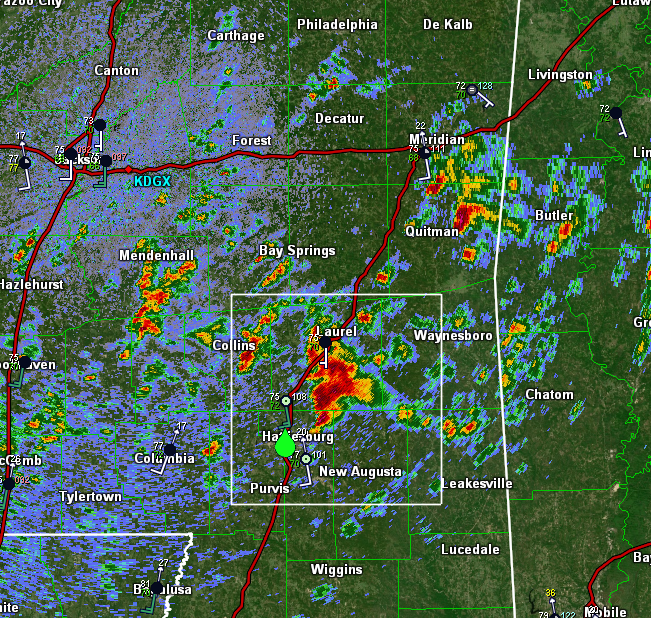
Cell near Hattiesburg #MSwx has rapidly punched up to about 50,000 feet which means it has broken through the capping inversion.
It is already exhibiting rotation on radar and is likely not far off from producing severe weather given the very favorable environment.
It is already exhibiting rotation on radar and is likely not far off from producing severe weather given the very favorable environment.

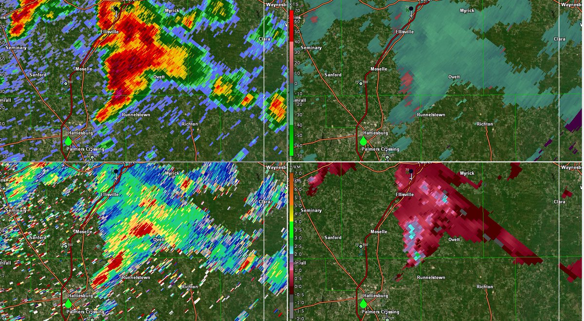
Looking at dual-pol data (ZDR bottom left), it appears this cell is already size-sorting raindrops with highest ZDR values along the forward flank gust front and lower ZDR values farther west/NW of the mesocyclone.
This helps infer the presence of rotation within the storm.
This helps infer the presence of rotation within the storm.
[11:49 AM EST 3/17/21] - looks like we have two strong mesocyclones in SE #MSwx, one near Sandersville and the other south of Myrick.
No warnings on these cells yet as rotation isn't strong enough to support a tornado as of now, but these cells are two to keep a close eye on.
No warnings on these cells yet as rotation isn't strong enough to support a tornado as of now, but these cells are two to keep a close eye on.

[11:53 AM CDT 3/17/21] - didn't take long for storms to initiate and start spinning over in #ALwx either. These cells are located between Tuscaloosa and Birmingham, and while they do not pose an imminent tornado threat right now, that may change soon.

[12:00 PM CDT 3/17/21] - welp that didn't take long... first tornado warning now up in far SE #MSwx for the cell we've been watching near Myrick.
gate-to-gate shear of about 90kts with the couplet axis parallel to the radar beam indicates very strong rotation, albeit aloft
gate-to-gate shear of about 90kts with the couplet axis parallel to the radar beam indicates very strong rotation, albeit aloft

[12:07 PM CDT 3/17/21] Three supercells lined up in #ALwx south of Birmingham... not great given the amount of shear available in the atmosphere to support rotation
[12:10 PM CDT 3/17/21] Strong supercell near Bessemer #ALwx may pose a serious threat to the Birmingham area shortly. Not tornado warned as of now meaning the threat isn't imminent, but it is rotating and may pose a tornado threat soon given the environment.

[12:13 PM CDT 3/17/21] Looks like the cell west of Wanesboro #MSwx is now producing a damaging tornado and lofting debris to around 20,000 feet (!!)


[12:25 PM CDT 3/17/21] Welp, if it's raining it's spinning over in #MSwx (and #ALwx).
Sure seems as though there's not much left to stop several of these storms from producing strong, long-track tornadoes. Two of them may be doing that already.
Sure seems as though there's not much left to stop several of these storms from producing strong, long-track tornadoes. Two of them may be doing that already.

First of what will unfortunately be quite a bit of damage now being reported in #MSwx.
https://twitter.com/NWSMobile/status/1372237473351397380
[12:49 PM CDT 3/17/21] Next up on the list of confirmed damaging tornadoes is the cell NW of Selma #ALwx headed towards Burnsville.
Drop in correlation coefficient collocated with the strongest couplet and high reflectivity values means the radar is seeing debris.
Drop in correlation coefficient collocated with the strongest couplet and high reflectivity values means the radar is seeing debris.


[12:56 PM CDT 3/17/21] This storm now appears to be "cycling" which is where the original tornado/mesocyclone give way to a new circulation a little downstream.
This remains an **extremely** dangerous storm and unfortunately shows no signs of slowing down given the environment.
This remains an **extremely** dangerous storm and unfortunately shows no signs of slowing down given the environment.

[1:05 PM CDT 3/17/21] Farther west, there is a tornado-warned storm near Brookhaven #MSwx that is exhibiting intense rotation and a classic "Bounded Weak Echo Region" (BWER, aka donut hole on the radar) which is a signal of extremely strong lift (precip suspended aloft)


[1:24 PM CDT 3/17/21] Latest tornado debris signature just popped up NW of Monticello #MSwx. This storm is behind the first round near the AL/MS border, and poses a good reminder that today's threat is not over after the first storm passes.

[2:23 PM CDT 3/17/21] Another strong tornado now lofting debris near Moundville #ALwx south of Tuscaloosa

[2:26 PM CDT 3/17/21] Just a little bit to the north, another strong supercell is located west of Birmingham #ALwx. No debris on radar as of now, but a tornado warning is out which means that a tornado is either imminent or occurring.
Don't wait to see debris to seek shelter!
Don't wait to see debris to seek shelter!

[2:35 PM CDT 3/17/21] The Moundville #ALwx storm continues to produce an extremely dangerous tornado moving off to the northeast.
This radar signature is as textbook as it gets with a well-defined hook, tight/extreme couplet, and low CC indicating lofting of debris.
This radar signature is as textbook as it gets with a well-defined hook, tight/extreme couplet, and low CC indicating lofting of debris.

[2:39 PM CDT 3/17/21] As best I can tell, this storm is currently lofting debris about 15,000 to possibly 20,000 feet above the ground. #ALwx

[3:06 PM CDT 3/17/21] Just a brutal scene here in central #ALwx with two supercells producing confirmed strong tornadoes and extremely efficient warm rain processes producing flash flooding in between.
[3:14 PM CDT 3/17/21] Just west of the storm producing a powerful tornado moving towards Brookwood is another supercell with strong rotation.
This cell, moving towards the city of Tuscaloosa, may pose a tornado threat given the environment, though it doesn't have a warning now.
This cell, moving towards the city of Tuscaloosa, may pose a tornado threat given the environment, though it doesn't have a warning now.

[3:18 PM CDT 3/17/21] Strong hook echo now developing on the storm SW of Tuscaloosa.
If you look at correlation coefficient you'll see lower values in this area. Does that mean debris? Not yet! The low CC values are in the storm's inflow notch with low reflectivity -> not debris
If you look at correlation coefficient you'll see lower values in this area. Does that mean debris? Not yet! The low CC values are in the storm's inflow notch with low reflectivity -> not debris

[3:21 PM CDT 3/17/21] This storm now has a tornado warning on it, including for the city of Tuscaloosa #ALwx

[3:24 PM CDT 3/17/21] Here's a view of this cell from the @abc3340/@spann skycam.
Doesn't appear to contain a tornado right now, but one could develop at any minute. #ALwx
Doesn't appear to contain a tornado right now, but one could develop at any minute. #ALwx

@abc3340 @spann [3:32 PM CDT 3/17/21] Tuscaloosa County providing a good reminder that the storm which wins the reflectivity beauty contest is not necessarily the storm that is most imminently dangerous.
Confirmed tornado with large TDS NE of Brookwood, no tornado (yet) with the Tuscaloosa cell
Confirmed tornado with large TDS NE of Brookwood, no tornado (yet) with the Tuscaloosa cell

@abc3340 @spann [3:52 PM CDT 3/17/21] While tornadic supercells continue to impact parts of #ALwx, it looks like two strong cells are rapidly developing farther west in #MSwx.
These cells, near Yazoo City, are moving NNE into what may be the most loaded thermodynamic environment over N MS.
These cells, near Yazoo City, are moving NNE into what may be the most loaded thermodynamic environment over N MS.

@abc3340 @spann [3:54 PM CDT 3/17/21] Back NE of Tuscaloosa #ALwx, it looks like the trailing supercell has tightened up north of Brookwood.
No sign of debris yet, but unfortunately that may change shortly
No sign of debris yet, but unfortunately that may change shortly


@abc3340 @spann [4:28 PM CDT] Tornado warnings continue N/W of Birmingham but the latest debris ball is down near Campbell #ALwx which is SW of Selma (unfortunately also under a tornado warning)

@abc3340 @spann [4:37 PM CDT 3/17/21] The supercell NW of Birmingham #ALwx has cycled again and is once again producing a debris ball signature on radar imagery

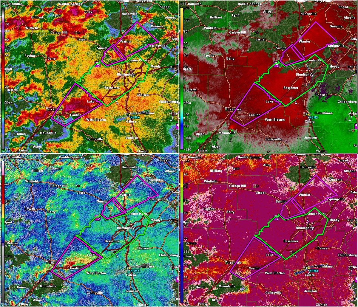
@abc3340 @spann [4:42 PM CDT 3/17/21] Is that two simultaneous tornadoes NW of Birmingham #ALwx?!
Both couplets look rotational and both are collocated with local minima in correlation coefficient values
Both couplets look rotational and both are collocated with local minima in correlation coefficient values

[5:02 PM CDT 3/17/21] Down in south/central #MSwx, a new trio of supercells is developing. One near Mount Olive, one near Raleigh, and another northeast of Decatur.
None of these are warned as of right now, but the environment remains extremely favorable for tornadoes.
None of these are warned as of right now, but the environment remains extremely favorable for tornadoes.

[5:22 PM CDT 3/17/21] Up in northern #MSwx, a cluster of storms is beginning to separate into a couple more discrete cells south of Pittsboro.
The central cell seems to be the strongest, with evidence of an emerging mesocyclone.
Though to track though since lowest radar is 9kft
The central cell seems to be the strongest, with evidence of an emerging mesocyclone.
Though to track though since lowest radar is 9kft

[5:24 PM CDT 3/17/21] Meanwhile in #ALwx, several supercells continue to produce tornadoes. These two are located between Birmingham and Montgomery, and the eastern one has a well-defined debris ball indicating an ongoing damaging tornado.

• • •
Missing some Tweet in this thread? You can try to
force a refresh