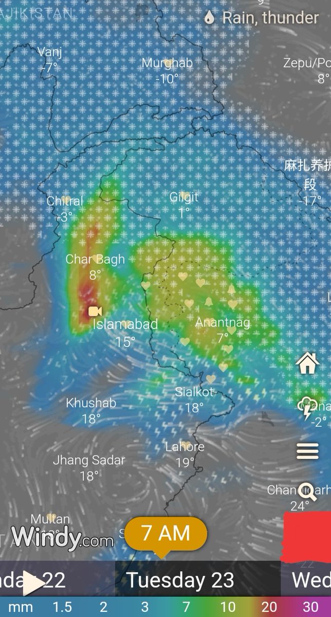
🔴Severe Weather(21 - 24 March)
🔴Strong Western Disturbance will effect Western Himalayan region from tomorrow morning.
➡️(Peak/Main) intensity will be on:- (21 morning/afternoon - night)
& ⚠️(from 22 March afternoon - 23 March late Night)⚠️.
⬇️Read more THREAD⬇️
(1/7)

🔴Strong Western Disturbance will effect Western Himalayan region from tomorrow morning.
➡️(Peak/Main) intensity will be on:- (21 morning/afternoon - night)
& ⚠️(from 22 March afternoon - 23 March late Night)⚠️.
⬇️Read more THREAD⬇️
(1/7)


➡️Under the influence of this weather system,most parts of J&K will receive
⚠️ moderate - heavy(rain/snow)thundershowers,lightnings, gusty wind, hailstorm.⚠️
➡️Heavy snowfall is also expected over Pir Panjal, Zanskar range.
⬇️(2/7)⬇️

⚠️ moderate - heavy(rain/snow)thundershowers,lightnings, gusty wind, hailstorm.⚠️
➡️Heavy snowfall is also expected over Pir Panjal, Zanskar range.
⬇️(2/7)⬇️


➡️Northern parts of #Pakistan(KPK,#Mardan, #Islamabad #Peshawar,#Lahore,#Chitral etc), North western #India(#Gurdaspur, #Amritsar,#Jalandharetc) will receive heavy thundershowers,hailstorm, Gusty wind,Lightnings.
⬇️(3/7)⬇️

⬇️(3/7)⬇️


🔴Probable effects of WD:-
1️⃣⚠️There are chances of Landslides,shooting stones(Sgr- Jmu NH),Mudslides & Avalanches in vulnerable areas of J&K and North Pakistan.⚠️
2️⃣⚠️There will be rise in the water level of Tributaries, Nallah's, Streams & in Jehlum river.⚠️
⬇️(4/7)⬇️
1️⃣⚠️There are chances of Landslides,shooting stones(Sgr- Jmu NH),Mudslides & Avalanches in vulnerable areas of J&K and North Pakistan.⚠️
2️⃣⚠️There will be rise in the water level of Tributaries, Nallah's, Streams & in Jehlum river.⚠️
⬇️(4/7)⬇️
3️⃣⚠️There are chances of waterlogging in low lying areas.⚠️
4️⃣⚠️There are chances of flash flooding in one or two places of J&K⚠️
5️⃣It may caus Disruption of surface transportation over higher reaches.
6️⃣There will be temperature drop of 8 - 16°C.
⬇️(5/7)⬇️
4️⃣⚠️There are chances of flash flooding in one or two places of J&K⚠️
5️⃣It may caus Disruption of surface transportation over higher reaches.
6️⃣There will be temperature drop of 8 - 16°C.
⬇️(5/7)⬇️
7️⃣To avoid loss farmers are advised to avoid spraying orchards during the mentioned period.
🔴I will give updates of weather systems(spells) by radar nowcasting using IMD Doppler radar Srinagar & PMD radar Islamabad. I will also use satellite data etc.
⬇️(6/7)⬇️
🔴I will give updates of weather systems(spells) by radar nowcasting using IMD Doppler radar Srinagar & PMD radar Islamabad. I will also use satellite data etc.
⬇️(6/7)⬇️
🔴Weather Models used for forecasting :- ECMWF, NOAA GFS, NEM, CMC GDPS, UKMO, ICON, IMD (IITM/NCMRWF)etc.
➡️Thanks for reading.
Stay safe.👍🏻
➡️(7/7)⬅️
➡️Thanks for reading.
Stay safe.👍🏻
➡️(7/7)⬅️
• • •
Missing some Tweet in this thread? You can try to
force a refresh


