This MAD sensor data can cue really powerful ground penetrating radars to determine the size of the underground voids associated with the traced electricity.
Then they can use AI to associate that with Hamas personnel movements in the
@TheDEWLine ...IDF version of Gorgon Stare wide angle video movement sensors to associate people with underground facilities.
This in turn cues Israeli Humint to get close to those people.
@sfrantzman@Jtruzmah The apples to apples comparison is the 2006 Lebanon War vs the 2021 Gaza war.
In 2006, after taking ~4000 rockets, Israel suffered 43 dead, 101 seriously wounded, ~ 1,300 who received 'light wounds' & the 2,770 who were treated for shock and anxiety.
Over 500 Israelis have been wounded in the 2021 Gaza fighting. However, applying the 1/12 ratio of seriously to lightly wounded in 2006 means ~42 were seriously wounded Israelis compared to 101 in 2006.
@mercoglianos Sal,
Ammo ships were specialized vessels.
And who "owned" shipping tonnage & ocean going vessels in WW2 is one of those not really looked at hard beyond institutional histories subjects.
The War Dept. used the War Shipping Administration as a beard for "their hulls."
@mercoglianos The War Department pre-war Army Transport Service (ATS) vessels were, under a 1941 reorganization, integrated into the Water Division of the US Army Transportation Corps. The Water Division operated a lot of coastal shipping crewed by the Coast Guard or foreign ships, only some
@mercoglianos of which were War Shipping Administration hulls.
MacArthur's SWPA was primarily operating with the British Admiralty and the Dutch to get hulls up to late 1943/Early 1944.
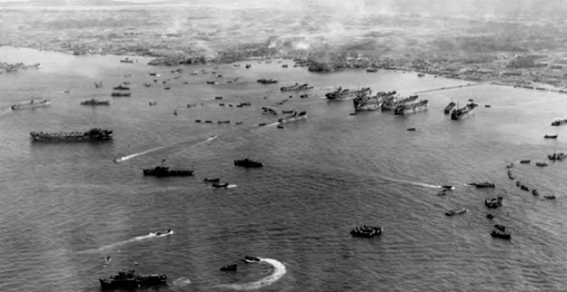
After a several weeks hiatus, this thread is revisiting the logistical disaster known as Operation Iceberg.
Specifically, it is looking at the planned versus executed beach clearance capability in the campaign. 1/
The opening tweet to this thread showed the "beach clearance standard narrative."
There was a lot more going on covering a much larger area of Okinawa and Ie Shima battle space.
The interactions between these beaches clearance supply capacity & operations is unexplored. 2/
This map is a big part of the unexamined beach clearance narrative. It is the map of the operations of the US Army 1st Engineer Special Brigade. One of the very few ETO units that made the trip to the Pacific and fought there as well. 3/
Regards US intelligence blind-spots Japanese air and sea power, the USN had a persistent & horrid weak spot on IJN radio-navigation.
Check this horrid bit of bureaucratic misdirection with Lorentz beams and IFF is from the USN NAVTECHJAP reports.
@CBI_PTO_History The navigation equipment throw away line about direction finding equipment refers to the Type 1 Air Mk III Direction Finder and Homing Device.
When you cross check with CINCPAC-5-45 "Japanese Radio Communications and Radio Intelligence" you find this...
* Course-indicator does not operate over great distances, has many defects. Appears that Japanese use this receiver in fighter aircraft to direct them to a rendezvous with enemy planes. Gear identical with that designed by Fairchild Aerial Camera Company. The antenna is
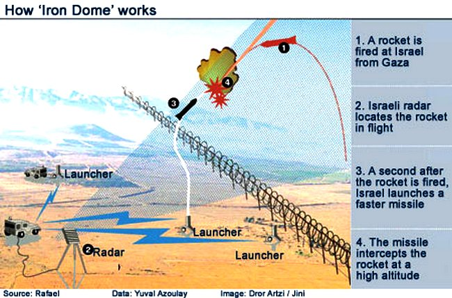
This thread is about the Israeli Iron Dome missile defense system - based on both recent events & my July 2014 Chicagoboyz blog post - that addresses the "Asymmetrical War" & Cold War ABM defense myths applied to Iron Dome versus its reality. 1/
I named that Chicagoboyz post as follows:
Iron Dome: Winning Asymmetric Warfare Through Superior Cost Accounting