This is a thread on Normandy/Overlord airpower, signals & invasion stripes.
There was a neat post by @militaryhistori about D-Day to D+1 airpower talking about how many aircraft sorties the Allies racked & stacked over Normandy 6-7 June 1945.
1/
There was a neat post by @militaryhistori about D-Day to D+1 airpower talking about how many aircraft sorties the Allies racked & stacked over Normandy 6-7 June 1945.
https://twitter.com/militaryhistori/status/1401230948025442308
1/
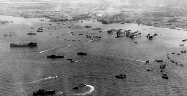
I replied to it with four photo captures of how the airpower flew during the daylight hours of June 6, 1944.
It was a whole lotta planes!
2/
It was a whole lotta planes!
https://twitter.com/TrentTelenko/status/1401352953559195648
2/

I wrote a thread dealing with all of the above over on the Chicagoboyz blog on 2019's 75th Anniversary of D-Day here:
How Allied Planes Got Their D-Day Invasion Stripes and other "Retro-High Tech" Secrets of the Normandy Invasion
chicagoboyz.net/archives/59917…
3/
How Allied Planes Got Their D-Day Invasion Stripes and other "Retro-High Tech" Secrets of the Normandy Invasion
chicagoboyz.net/archives/59917…
3/
I've learned a bit more about the Allied signals of D-Day since 2019. So I'll try and walk you through how the problems of D-Day signals planning lead to the famous invasion stripes.
Note: This is your long thread warning.
4/
Note: This is your long thread warning.
4/

What we call "Spectrum management" today was a huge issue in WW2.
Only the Ham radio community has any memory of that issue as the academic history community tends to run away screaming from history involving radio bandwidth, frequency, wavelength,
forums.qrz.com/index.php?thre…
5/
Only the Ham radio community has any memory of that issue as the academic history community tends to run away screaming from history involving radio bandwidth, frequency, wavelength,
forums.qrz.com/index.php?thre…
5/

...quartz crystal radio control, atmospheric transmissibility, radio ducting & how all this related to the command, control, communications & intelligence (C3I) systems of the Normandy Invasion.
How complicated the state of the art has become in 77 years doesn't help.
6/
How complicated the state of the art has become in 77 years doesn't help.
6/

Professor Brian Austin G0GSF/ZS6BKW gave a WW2 spectrum management talk at an IEEE talk about 20 years ago & the broad outline started with the fact that the 2 to 9 MHz part of the High frequency (HF) spectrum was crowded.
Antenna theory and pattern modelling was in
7/
Antenna theory and pattern modelling was in
7/


...its infancy, and the concepts of NVIS and "skip zones" were not fully exploited.
Conventional pre D-Day radio communications practice made the 2 to 9 MHz part of the HF spectrum extremely crowded.
8/
Conventional pre D-Day radio communications practice made the 2 to 9 MHz part of the HF spectrum extremely crowded.
8/


The SHAEF radio network planners working with Marconi at Great Baddows estimated that a minimum of 10K radio circuits would be required for successful execution of "Operation Overlord", and that spectrum for perhaps 4K was available using conventional planning techniques.
9/
9/

These bandwidth issues extended to the VHF frequency bands. The fundamental problem Normandy campaign was the Western Allied powers were going to put more planes & ships into their respective air and sea space than could be effectively controlled by the available C3I systems
10/
10/
The quartz crystal control VHF (think TV channels 1 thru 13) radios and the meter band radars did not provide enough bandwidth for communications nor precise target definition and altitude for tight two way radio directive control of fighter patrols or surface ship screens.
11/
11/


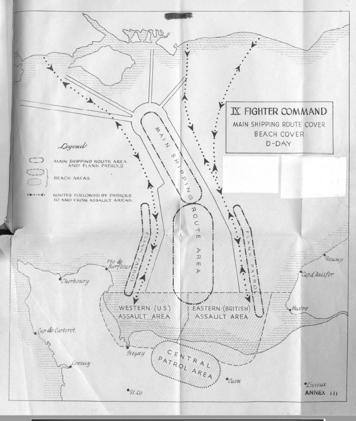
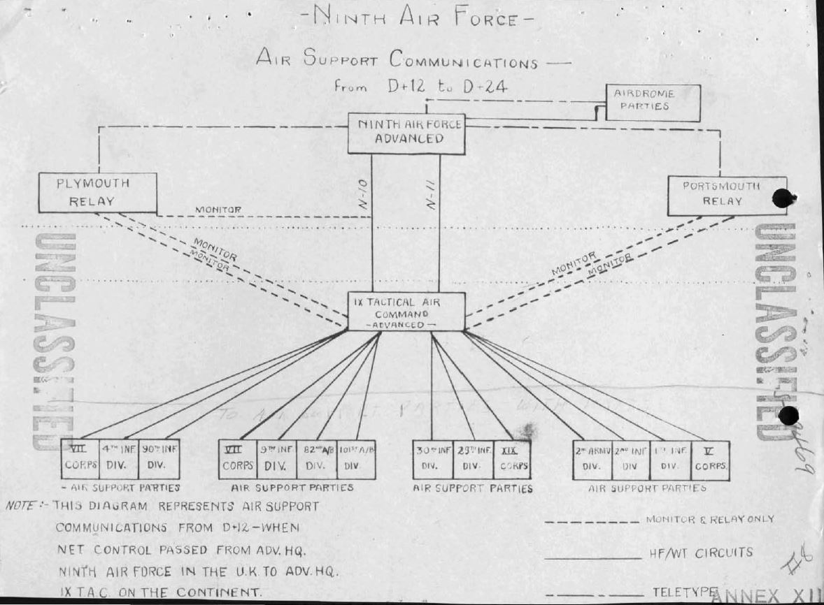
In an operation as large as Operation Neptune, planning had to start early. It had to be comprehensive. And it had to include every possible contingency. This detailed planning kicked off in January 1944. See the attached Operation Neptune Detailed Planning Time Table.
12/
12/

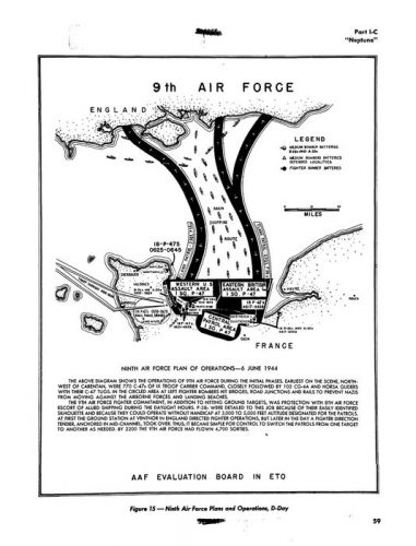
This detailed planning included the following issues to be addressed based on the operational experiences of the Operations Torch, Husky, Baytown, Avalanche and Shingle. See the figure from Army Air Forces Historical Study No. 36:
13/
13/

This planning process was heavily disrupted, in terms of signals and frequency allocation when General Bernard Montgomery took over invasion planning of 21st Army Group and added additional infantry divisions to the initial assault forces. To deal with this change a series
14/
14/

of boards, committees and sub-committees were created to deal with the new invasion plan. This and the previous tweet are the balance of the Operation Neptune Boards w/a list of the Committees and Sub-Committees dealing with issues of radio spectrum and frequency management.
15/
15/

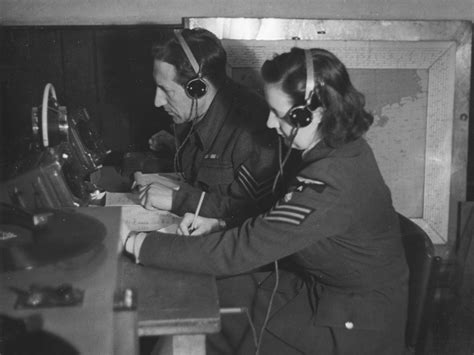
It was the Mutual Interference Sub Committee, Combined Signal Board, Supreme Allied Command that drove the signals plans for Normandy. It did this via a series of practical exercises to determine primary, 2nd and 3rd order harmonic interference patterns for every piece of
16/
16/

radar and radio kit in the invasion with priorities on which system gets the best terrain features.
The 21st Meeting of the Combined Signal Board, 14 May 1944 index is from "Rpt of Signal Division Supreme Headquarters Allied Expeditionary Force – Op "Overlord" – vol. I, II,
17/
The 21st Meeting of the Combined Signal Board, 14 May 1944 index is from "Rpt of Signal Division Supreme Headquarters Allied Expeditionary Force – Op "Overlord" – vol. I, II,
17/
& III – undated – Hqs. AEF.
This in turn caused a large number of mathematicians in uniform to start determining frequency allocation via working with a then 26 year old math formulas governing telephone call traffic engineering and queueing theory invented by a
18/
This in turn caused a large number of mathematicians in uniform to start determining frequency allocation via working with a then 26 year old math formulas governing telephone call traffic engineering and queueing theory invented by a
18/

...Danish telephone engineer by the name of Agner Krarup Erlang.
The Erlang C formula determined the required number of staff based on the forecast workload for incoming calls, together with variables such as the percentage of calls answered within a given number of seconds.
19/
The Erlang C formula determined the required number of staff based on the forecast workload for incoming calls, together with variables such as the percentage of calls answered within a given number of seconds.
19/

What these mathematicians in uniform were doing is known today as Frequency Deconfliction.** It was accomplished in the spring of 1944 with ledger books, lots of skull sweat and endless meetings where officers with stars in a rainbow of different service uniforms shattered
20/
20/

...many days or weeks of calculations due to rearrangements of who owned which piece of the radio spectrum.
Civilian experts such as Dr. Harold Beverage from RCA were called upon and proposed a quite different approach to radio network management.
21/
Civilian experts such as Dr. Harold Beverage from RCA were called upon and proposed a quite different approach to radio network management.
21/


This approach could be summarized in three points:
1. Divert communications away from HF, to wire, VHF & UHF
2. Exploit spectrum reuse through skip zones, time sharing & horizontally polarized antennas w/better defined vertical patterns
3. Use tight beam directional antenna's
22/
1. Divert communications away from HF, to wire, VHF & UHF
2. Exploit spectrum reuse through skip zones, time sharing & horizontally polarized antennas w/better defined vertical patterns
3. Use tight beam directional antenna's
22/

So what does all this have to do with D-Day invasion Stripes?
Quite a bit.
The last major meeting of the Combined Signal Board concluded that the thousands of aircraft involved in the invasion would saturate and break down the Allied Mark III IFF system.
23/
Quite a bit.
The last major meeting of the Combined Signal Board concluded that the thousands of aircraft involved in the invasion would saturate and break down the Allied Mark III IFF system.
23/


This same meeting also approved an alternate visual identification system to replace it - Invasion Stripes.
This visual identification system was pure RAF in origin and it came from horrid experience. Namely, it turned out that both the Hawker Typhoon and early production
24/
This visual identification system was pure RAF in origin and it came from horrid experience. Namely, it turned out that both the Hawker Typhoon and early production
24/

...Hawker Tempest Mark Vs had very similar short noses and wing taper to German FW190's when seem from above and below.
Both planes were taking fire from other RAF fighters -- mainly Fighter Command Spitfire V's -- intended for the Focke-Wulf Fw 190.
25/
Both planes were taking fire from other RAF fighters -- mainly Fighter Command Spitfire V's -- intended for the Focke-Wulf Fw 190.
25/


When Air Chief Marshal Sir Trafford Leigh-Mallory, commanding the AEAF approved the invasion stripes. It wasn't simply a negative control "don't shoot me" measure. The Allies were reverting to a Western Front WW1 aerial tactic. They were doing standing fighter patrols.
26/
26/

The RAF used standing fighter patrols not only on the WW1 Western front, but also in the Western Desert through 1942, until they had enough radars and VHF band radios to actively control their fighter-interceptors there.
27/
27/


The reason for this was lack of bandwidth.
The primary VHF fighter radio for the Allied air forces in the United Kingdom in June 1944 was the SCR-522 or a British radio that the SCR-522 was copied from.
28/
The primary VHF fighter radio for the Allied air forces in the United Kingdom in June 1944 was the SCR-522 or a British radio that the SCR-522 was copied from.
28/

The SCR-522 was the predominant fighter radio in the Normandy invasion & had four amplitude modulated (AM), push button, quartz crystal frequency controlled channels that transmitted between 100 Mhz and 156 Mhz.
29/
29/

A typical US Army Air Force WW2 fighter squadron set it's SCR-522 as follows:
Channel A is the frequencies for all planes;
Channel B is the squadron command frequency;
Channel C is the D/F* homing frequency;
Channel D is the D/F* fix frequency"
.
*D/F means direction finding
30/
Channel A is the frequencies for all planes;
Channel B is the squadron command frequency;
Channel C is the D/F* homing frequency;
Channel D is the D/F* fix frequency"
.
*D/F means direction finding
30/


There were going to be _171_ Allied fighter squadrons in Operation Neptune. To give each of those 171 squadrons the standard four frequencies operationally required would call for 564 separate radio channels. Worse, each squadron was between 12 (RAF) and 16 (USAAF) fighters.
31/
31/

So you would be looking at between 2052 and 2736 transmitters on those frequencies. If you think digital WiFi congestion of 50 lap tops and tablets at your local Starbucks is bad. That's nothing compared to the physical impossibility of putting 564 analog radio channels,
32/
32/


...with ~2300 transmitters, between American broadcast television channel's 6 and 7.
Worse, the SCR-522's radio band also covered that of the Mark III IFF system.
So...no IFF for you over Normandy.
33/
Worse, the SCR-522's radio band also covered that of the Mark III IFF system.
So...no IFF for you over Normandy.
33/


The Desert Air Force standing fighter patrols used the "Running commentary" fighter control system in 1940-41 that broadcast plots of German air movements using radar and Y-service intercepts of German Luftwaffe signals so pilots could use the information & their initiative
34/
34/


...to deal with German raids.
This was the same sort of running commentary fighter control system that German night fighters later adopted to deal with RAF Bomber Command jamming limited Luftwaffe radio bandwidth over Germany in 1943.
35/
This was the same sort of running commentary fighter control system that German night fighters later adopted to deal with RAF Bomber Command jamming limited Luftwaffe radio bandwidth over Germany in 1943.
35/

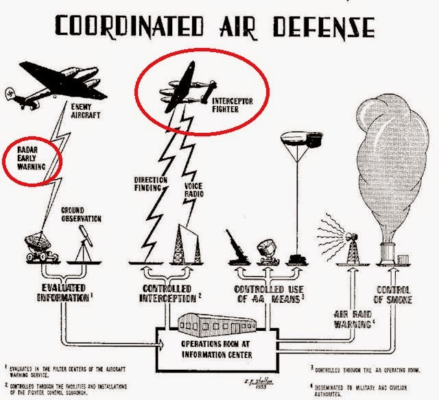
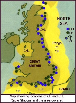
The real C3I issue for the invasion fleet was how to practically see & control the land based airpower protecting it while directing it's use over the beach head. The Normandy Coast was too far away for the land based radar network of Britain to be of practical use.
36/
36/


The Allied invasion fleet had to bring it's own radar, radar height finding, radio & Y-service radio intercept capabilities for fighter direction with it. And it had to command naval, air and ground forces simultaneously.
37/
37/


And executing those C3I roles is where the centralized command, combined nationality and joint service amphibious warfare culture of the Western Allies in Europe was radically different that the US Navy/US Marine Corps amphibious culture of the Pacific.
38/
38/
The UK Royal Navy's armored carriers simply did not have the internal space for a US Navy style fighter direction system. And even if they did, it was still not anywhere near enough space to control the high hundreds hundreds to high thousands of land based planes
39/
39/


...the Allies in Western Europe routinely brought to bear from 1943 onward.
There was simply no real way to have a US Navy style AGC amphibious command ship could do both the jobs of fighter direction and landing force high level command. This was due to both frequency
40/
There was simply no real way to have a US Navy style AGC amphibious command ship could do both the jobs of fighter direction and landing force high level command. This was due to both frequency
40/
...bandwidth/interference issues on the AGC and because when this was attempted w/the USS Ancon (AGC-4) at the Salerno landings. Luftwaffe signal intelligence used direction finding to isolate it's location and dispatch specialized anti-ship squadrons to attempt to sink it!
41/
41/


What was used for the amphibious fighter control role were RN/RAF fighter direction tenders (FDT) with a full RAF Fighter sector & Y-service SIGINT & D/F team.
These ships did air traffic control as well as "running commentary" to the 171 fgtr sqds involved in Op. Overlord.
42/
These ships did air traffic control as well as "running commentary" to the 171 fgtr sqds involved in Op. Overlord.
42/

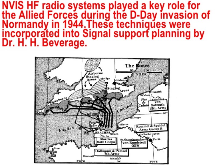
This map shows where the FDT providing the 'running commentary' fighter direction were for D-Day. FDT 13 handled air traffic control to and from Britain.
FDT 216 handled the U.S.'s western beaches while FDT 217 supported the eastern British beaches.
43/
FDT 216 handled the U.S.'s western beaches while FDT 217 supported the eastern British beaches.
43/

"Running commentary" fighter direction and invasion stripes were in no way an efficient use of airpower resources.
It was however, an EFFECTIVE, use of airpower resources that was efficient in available bandwidth. And it is a story that deserved to be more widely known.
/End
It was however, an EFFECTIVE, use of airpower resources that was efficient in available bandwidth. And it is a story that deserved to be more widely known.
/End
@threadreaderapp unroll
• • •
Missing some Tweet in this thread? You can try to
force a refresh