ECMWF ensembles showing the Fujiwhara effect between Typhoon #Cempaka 🌼 and Typhoon #Infa 🎆 as the two storms were forecasted to move around each other 🌀
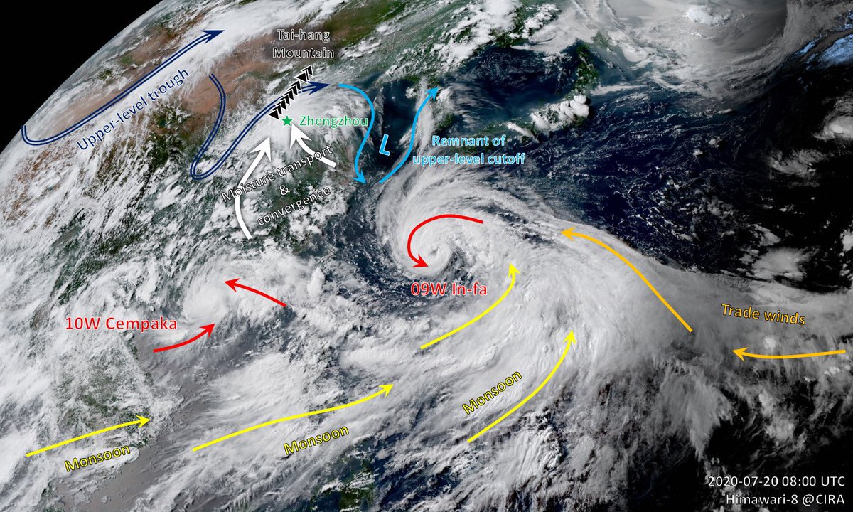
That is one big monsoon gyre circulation over the northwest Pacific, formed by converging easterly trade winds and westerly monsoons. It gave birth to #Cempaka and #Infa. It might give birth to more typhoons.
Typhoon #In-fa has an eye in formation this morning (meaning: "fireworks" in Cantonese 🎆 name origin: Macao). Improving structure despite some dry air issues. #In-fa is forecasted to detach from its monsoon "tail" and continue to intensify while moving towards Taiwan.
#Cempaka has been nearly stationary just offshore of Guangdong with a midget core and well-defined eye. Increasing "Fujiwhara drag" from #Infa is about to pull it into a counter-clockwise loop. (#Cempaka meaning: a type of tree with fragrant flowers 🌼 name origin: Malaysia)

• • •

Missing some Tweet in this thread? You can try to force a refresh
 

Keep Current with Minghao Zhou

Minghao Zhou Profile picture

Stay in touch and get notified when new unrolls are available from this author!

Read all threads

This Thread may be Removed Anytime!

PDF

Twitter may remove this content at anytime! Save it as PDF for later use!

Try unrolling a thread yourself!

how to unroll video
  1. Follow @ThreadReaderApp to mention us!

  2. From a Twitter thread mention us with a keyword "unroll"
@threadreaderapp unroll

Practice here first or read more on our help page!

More from @Minghao_Zhou

21 Jul
Archived content: sketch of how extreme rainfall in Zhengzhou, China was related to (1) moisture transport enhanced by the monsoon gyre, (2) deepening upper-level trough, and (3) leeward inverted trough and upslope flow. 1/n Image
#Henan province has seen 837 stations with 24 hour rainfall amount of 100mm+ (~4"+), 195 stations above 250mm+ (~10"+), with the bullseye centered over the state capital of #Zhengzhou, which was submerged under widespread 400~600mm totals. ImageImage
Maximum hourly rain rate observed at #Zhengzhou was a staggering 201.9mm between 4-5pm local time. This is a new record for all 2418 national stations in mainland China and possibly the largest downpour in human history for a city with 10+ million population. Image
Read 6 tweets
19 Jul
Typhoon #Cempaka rapidly intensifying while drifting slowly offshore of Guangdong Province, China (#Cempaka name meaning: a type of tree with fragrant flowers 🌼 name origin: Malaysia)
#Cempaka has reached 65 kts, 977 hPa per JTWC and 38 m/s, 965 hPa per CMA, despite initial expectations to remain a tropical storm. The land-sea surface friction contrast has caused #Cempaka's most intense convection to locate in the SW quadrant with a slightly elliptic eye. Image
My idealized simulations showed the predictable patterns of such asymmetry induced by friction, and their possible contributions to near-shore intensification of TCs👇 Image
Read 4 tweets

Did Thread Reader help you today?

Support us! We are indie developers!


This site is made by just two indie developers on a laptop doing marketing, support and development! Read more about the story.

Become a Premium Member ($3/month or $30/year) and get exclusive features!

Become Premium

Too expensive? Make a small donation by buying us coffee ($5) or help with server cost ($10)

Donate via Paypal Become our Patreon

Thank you for your support!

Follow Us on Twitter!

:(