Invest 95L es el próximo sistema de origen africano localizado ya casi a medio camino hacia las Antillas. La probabilidad de desarrollo llega a 70% (CNH). El único factor que inhibe su fortalecimiento son los fuertes vientos del este en altura, pero se espera que eso disminuya 1/
Existe aire sahariano seco al norte de 95L pero los modelos muestran que el núcleo de aire húmedo debe permanecer más intacto que el de pre-Fred.
2/
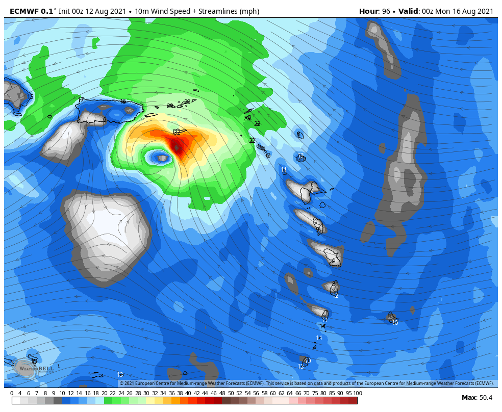
Hasta el momento, el modelo europeo le ha ido bien en interpretar lo que viene ocurriendo en vida real. Y ese modelo trae una tormenta tropical al sector de PR/RD entre domingo y lunes.
@TropicalTidbits@weatherbell Sin embargo, el GFS americano no comparte esa opinión, pasando una onda por nuestra área en vez de una tormenta. Pero hay varios modelos de intensidad que proyectan que entre 72 y 96 horas (domingo a lunes) habría una tormenta o huracán categoría 1.
@TropicalTidbits@weatherbell@HurricaneModels Varias trayectorias modeladas (dado que está empezando en 14°N de latitud) llevan a 95L al *norte* del Caribe (imagen via @weatherbell), posibilidad la cual no se puede descartar. Por el momento estaremos atentos a su comportamiento
¡7 semanas hasta el final de septiembre!
5/5
• • •
Missing some Tweet in this thread? You can try to
force a refresh
Confidence grew Sunday in the #Mitlon track forecast, which climbed from low to moderate, trending higher. It's hard to find global, specialized, or ensemble model track with landfall outside of the Cedar Key to Ft. Myers stretch of Florida's west coast. (GIF via @burgwx) 1/
While there's been a lot of emphasis in recent years on impacts beyond the inner core of hurricanes, this time the actual track of the eye matters a *ton*. West coast of Florida residents near and south of where the eye hits will be impacted by a killer storm surge of 10+ ft. 2/
A major hurricane tracking nearly perpendicular to Florida's west coast is a rarity. It can happen. It has happened. But we have to go back to the 1800s to find examples. One of those, the Great Gale of 1848, led to the worst Tampa Bay storm surge ever recorded. 3/
Potential Tropical Cyclone 7
11:00 AM AST Fri Aug 13
Location: 15.3°N 49.3°W
Moving: W at 21 mph
Min pressure: 1010 mb
Max sustained: 35 mph
Por las razones delineadas ayer, este #PTC7 debe convertirse en tormenta mucho antes de lo que lo logró Fred. El CNH está siendo sumamente conservador en proyectar una tormentita de 45 a 50 mph para PR/RD, pero les recuerdo que intensidad es lo que somos peores proyectando.
2/
Yo me prepararía para algo más fuerte, aunque como mostré hoy tampoco es como que tiene mucho tiempo para llegar a ser huracán — se mueve a 21 mph (33 km/hr). El GFS la pone más fuerte, por lo cual gira más pronto hacia el norte. El europeo más débil y por ende sobre tierra
By now you know that there’s not much risk of a windstorm. Even if Fred somehow revives there’s not enough time for it to be more than a minimal tropical storm by the time it passes near or over South Florida & the Keys. The updated chance for storm-force winds as of 11 (%):
1/
W Palm Beach 11
Ft Lauderdale 13
Miami 10
Homestead 11
Marathon 29
Key West 21
Naples 26
Ft Myers 12
Tampa 22
Orlando 7
2/
So today it’s time to start focusing on the bigger threat from Fred as a storm or Fred’s remnants as a tropical wave — heavy rain. We’re used to multiple inches of rain even on a summer afternoon. But in these type of events you can get persistent bands over the same spot…
3/
Volume increasing (at least on local news) from frustrated residents of South Florida’s flooded neighborhoods. I can refer you to my timeline for previous posts on this matter, but let me summarize again:
(1) no system is designed to absorb 18 inches of rain in a day
(2) Granted, some flood mitigation is possible. I said mitigation, not elimination. E.g. the C-4 Basin in Miami-Dade put in place after the 2000 No Name Storm. And pumps. These things cost big big bucks. Meaning higher taxes. So people against higher taxes can’t have it both ways
(3) This particular event had a 1% chance of occurring in any year. But we’ve had many 1-in-100 year events just over the course of the last 25 years. Statistics are static and don’t incorporate the changing dynamics being driven by #ClimateChange
3/
The dry air from the upper level low has arrived, while wind shear and land interaction impact the storm. The storm is, at least for now, weakening. Tellingly, the Hurricane Watch for South Florida has *not* been upgraded to a Warning.
1/
Models, which have now benefited from 2 surveillance missions from the G-IV jet sampling the environment on 3 sides of Eta, have joined the anticipatory Euro which was calling for a hard-left out of Cuba. While that turn has yet to happen, Eta is slowing — a sign of imminent turn
As a result, NHC has pushed their forecast track south yet again — now showing the center passing 94 miles away from Miami and making landfall as a robust tropical (or subtropical) storm in the Lower Keys very late tonight. On the map, blue depicts the Tropical Storm Warning
I’ve been answering everyone individually but let’s do a shutters post for all. Shutters are generally required for winds in excess of 105 mph, which are the ones that can lift non-aerodynamic objects like roof tiles and such. Eta is forecast to be a 70 MPH tropical storm
1/
Now, that’s not to say that there isn’t an outside chance that it will become a Cat 1 hurricane and — this is important — *sustain* that intensity through Monday. So, let’s consider a reasonable worst case scenario. Conveniently, @NWSMiami does that for us.
2/
@NWSMiami This is considered a scenario that has a 10% chance of occurring. It shows hurricane winds for coastal #Miami-Dade east of I-95 or US-1 and the Upper Keys. There’s a 90% chance that it won’t happen, and anything stronger isn’t in the cards according to the experts.
3/