Raj Bhagat P #Mapper4Life Profile picture
Aug 18, 2021 19 tweets 10 min read Read on X
Viz: #Kaveri river watershed 😍

I would be posting some #maps about the river with finer details in this thread in coming days! Bookmark.. Image
FAQ
Data: SRTM
Software: QGIS
One of the biggest engineering works in Kaveri river is the Kallanai / Grand Anicut system. It was not constructed in 1 step & most of the structure that we see were erected during British era

Annotated drone image from @vikatan. The subsequent tweets deal with history of dam Image
Prior to the construction of the structures in Kaveri delta, it is likely that the river and its distributaries split in different places. The sediment deposition , erosion made the river to change the course constantly and through the years it developed many channels for flow Image
Somewhere during the sangam era, it is likely that the Kaveri river was filled with too much deposit & height of river bed rose. It led to the subsequent breaking of the banks causing the formation of Ullar river ((& Srirangam Island) and draining into Kollidam river Image
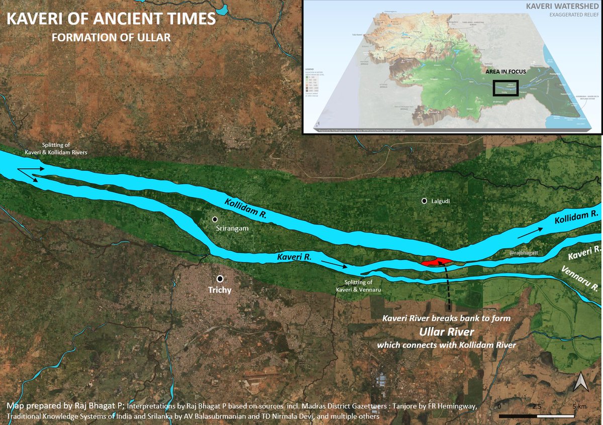
To prevent water going to Kollidam river & to retain water in Kaveri river (for Agriculture purposes), 1st step of engineering commenced leading to the building of Kallanai (Stone Dam) shown in #map. This was most probably executed by Karikalan but reconstructed many times over Image
In 1851 CE (British Era), two regulators were built to regulate the distribution of water between Kaveri & Vennar rivers. They were few kms above the Kallanai dam. Image
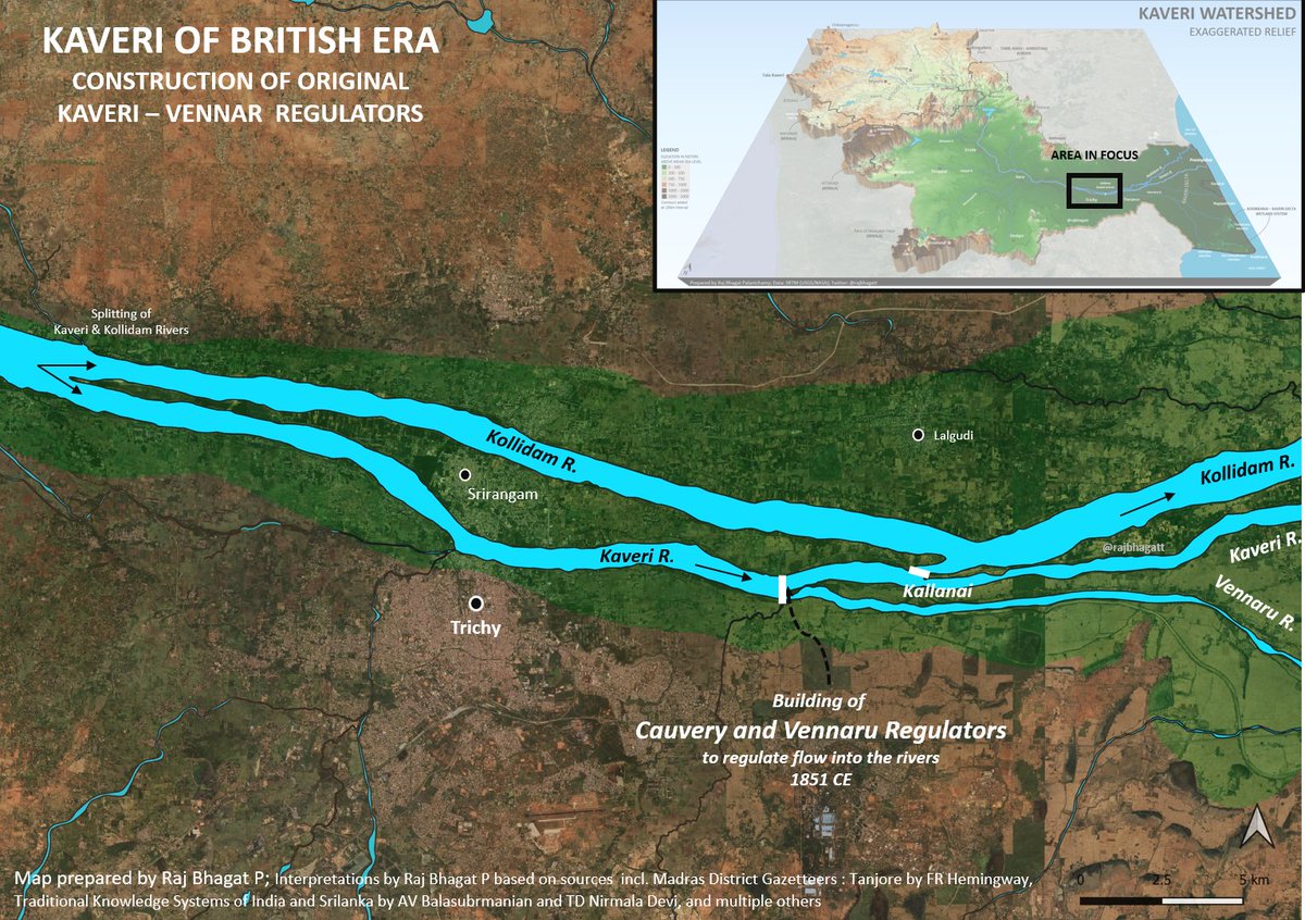
It was decided to bring the above regulators closer to Kallanai and in 1886 CE, the course of the Vennar was artificially changed. It was made to start closer to the Kallanai. The old course and the new course are shown in the #map Image
The new regulators for Kaveri and Vennar (course of which was modified) were constructed in the current site closer to the Kallanai and thus the "Grand Anicut" took a bigger and grander form! Image
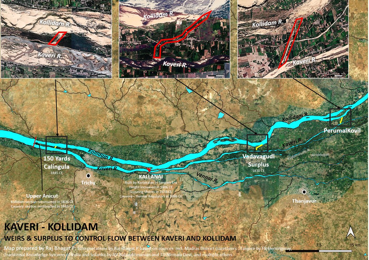
It was not just grand anicut, in the 1800s the British (led by Sir Arthur Cotton & other engineers) built multiple other regulators, weirs, surplus canals that moderated and disributed the water flow between Kaveri river & the Kollidam. They were also constantly rebuilt & modifed Image
The final addition to Grand Anicut was Grand Anicut Canal. A dam was constructed in Mettur by 1934 & a new canal was constructed to irrigate more land under the Kaveri delta system which was also made to start at the same site Image
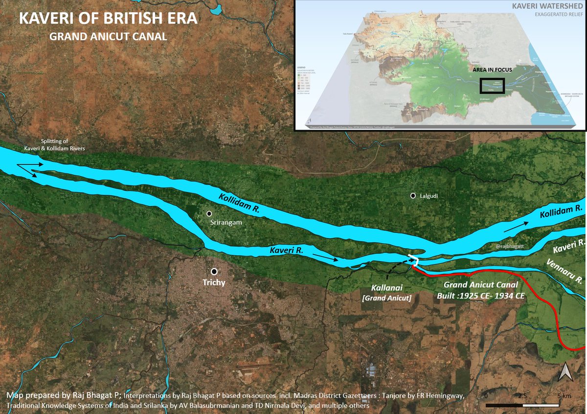
With the addition of GA Canal, the Kallanai or Grand Anicut took the modern form with multiple regulators that we see right now. Not all of them were constructed in same time! Image
The final leg (GA Canal shown in red colour) irrigated a lot of land that were earlier rainfed/tank/groundwater irrigated land. This newly added region is now called informally as New Delta. Mannargudi marks the border between the old and the new deltas Image
Even though nearly a century has passed since the construction of the GA Canal, underlying social differences still remain even in 2011. The Old delta has a higher proportion of Scheduled Caste population whereas the new delta has low proportion as shown in #map Image
Humpbacked Mahseer is a large #fish found only in #Kaveri & its tributaries. #Map shows where fish is found (area in red)

Dams & other human activities have pushed it to verge of extinction. New Dams(eg Mekedatu) would sound deathknell for fish
Data @stevenlockett @MahseerTrust Image
The primary source of #Bengaluru's water supply is #Kaveri river even though only a part of the city is in the watershed.
The city being in higher grounds than Kaveri pumps the water for a distance of about 100 km over a height of 1000 feet. Image
This visualization was created to show the elevation profile of the Kaveri pumping system for #Bengaluru City Image
Topography around Bengaluru can be seen in this visualization

#Kaveri is one of the most exploited river systems with thousands of manmade tanks (which many believe as natural) and other structures. Natural flow is limited to a few sections of the river and they correlate with habitats of native Mahseer

• • •

Missing some Tweet in this thread? You can try to force a refresh
 

Keep Current with Raj Bhagat P #Mapper4Life

Raj Bhagat P #Mapper4Life Profile picture

Stay in touch and get notified when new unrolls are available from this author!

Read all threads

This Thread may be Removed Anytime!

PDF

Twitter may remove this content at anytime! Save it as PDF for later use!

Try unrolling a thread yourself!

how to unroll video
  1. Follow @ThreadReaderApp to mention us!

  2. From a Twitter thread mention us with a keyword "unroll"
@threadreaderapp unroll

Practice here first or read more on our help page!

More from @rajbhagatt

Feb 25
Here's a compilation of my #maps which can help you in understanding the #Bengaluru #Water situation a bit better.

Bengaluru is unofficially a hill station which is located nearly a kilometre above sea level. Image
Being in the top of a ridge line, the city is partly within Kaveri watershed and partly in Ponnaiyar (Dakshina Pinakini watershed).
Being on top, water from elsewhere dont flow through Bengaluru but flow outward from the city
Image
Image
Bengaluru right now depends on Kaveri river for water supply. Because of its height, Water is pumped for a height of 1000 feet from the river 100km away from the city Image
Read 15 tweets
Feb 4
Here is the story of how @googlemaps helped me recover items stolen in a moving train from my father.

My father was travelling from Nagercoil to Trichy in sleper class in Nagercoil - Kacheguda express. He had boarded at 1:43 AM from NCJ. The train was relatively empty & another person who boarded along with my dad stole my dad's bag and mobile phone from him, and deboarded the train in Tirunelveli Junction.Image
When my dad realized it, he searched in the train and rang me from his friend's phone at 3:51 AM to inform that his phone was stolen. Luckily, among immediate family members we have location sharing "on" which meant I could track the location of mobile. When I checked it, I realized that the mobile was moving along the track near Melapalayam in Tirunelveli so I deduced that the thief was returning back to Nagercoil in another train.Image
I called my close friend Babin who is also a local DMK (@arivalayam) functionary to help me recover this. And we both went to Nagercoil station to catch the theif. The railway police listened to us and one of them came along. This is a snapshot of Google maps at the time when I was waiting railway station and the theif was still having my dad's phone.Image
Read 8 tweets
Dec 10, 2023
Thread:
I'll summarise the #Chennai cyclone event and the flooding issue once again as I feel that there is a lot of misinformation floating around which could guide people and government in wrong way w.r.t future actions
#ChennaiFloods2023
1/n Image
1. The cyclone path had been more or less accurately predicted by IMD, private forecasters

2. The intensity of rainfall however was not clear as per official forecast though it was expected to be heavy, it was not indicated that it would be near record rainfall
3. Though private forecasters including myself had warned about the possibility of extreme nature of rainfall, there was always a doubt and it is difficult for the government to take decisions based on non-official arms like mine and it would be too much of a risk for them Image
Read 23 tweets
Dec 4, 2023
Short thread:
#Chennai, lakes, and floods

I have written some threads about the flooding in Chennai, this one would focus specifically on the lake aspect.

#Map below shows the flood forecasted areas in Chennai for an extreme amount of rainfall. If we carefully look into this forecast map, we can see that apart from the major rivers, there are many other paths for the water to run which appear like a tree branching out.

This forecast based on coarser DEM with extreme rainfall & was prepared by my team mates @smkirthiga & pavithra

Pardon the visual quality of maps since I dont have much time to prepare this
Image
If we look at the topography map, the flow paths become clearer as in the map below. When water falls in these places, they are supposed to drain along these streams which appear only during monsoons Image
Let us zoom in further, these "conduits" are the ones that are supposed to carry water. I have added some water flow lines on top of the topography map here near Pallkaranai wetlands Image
Read 15 tweets
Oct 13, 2023
Thread:
A recent #satellite image of the sea near #Chennai's Marina beach. There are 3 dots in the image (red, green, blue). What causes it? Image
Satellites have cameras that observe reflection in different spectral bands (including red, green, blue). But they don't observe the same place at the same time and there is a very small lag between them. Meaning between red colour and green colour there is a time difference Image
Most of the objects (like buildings, lakes etc.) that satellites observe don't move that fast in microseconds and hence when image collages are created, it won't show any major difference. But what if objects like Aeroplane which move at say 800kmph is observed? Image
Read 6 tweets
Oct 8, 2023
#Thread: A Problem in the making. Two major problems faced by #Bengaluru are flooding and traiffic. But just like any other Indian city, unbridled urbanization is aggravating these crises and is making sure that these problems would stay for longer
1/n Image
In my previous posts, I have explained about the topography and valley system in #Bengaluru. These conveyor belts carry the flood waters of the city. It is across these valleys small dams were built primarily for irrigation purpose (which we now call as lakes)
2/n Image
The problem is that a lot of builtup area came across these valleys. Because of the way we construct, the materials we use, and them behaving as blocks, Bengaluru began having flooding problems as the valleys got blocked
3/n Image
Read 17 tweets

Did Thread Reader help you today?

Support us! We are indie developers!


This site is made by just two indie developers on a laptop doing marketing, support and development! Read more about the story.

Become a Premium Member ($3/month or $30/year) and get exclusive features!

Become Premium

Don't want to be a Premium member but still want to support us?

Make a small donation by buying us coffee ($5) or help with server cost ($10)

Donate via Paypal

Or Donate anonymously using crypto!

Ethereum

0xfe58350B80634f60Fa6Dc149a72b4DFbc17D341E copy

Bitcoin

3ATGMxNzCUFzxpMCHL5sWSt4DVtS8UqXpi copy

Thank you for your support!

Follow Us!

:(