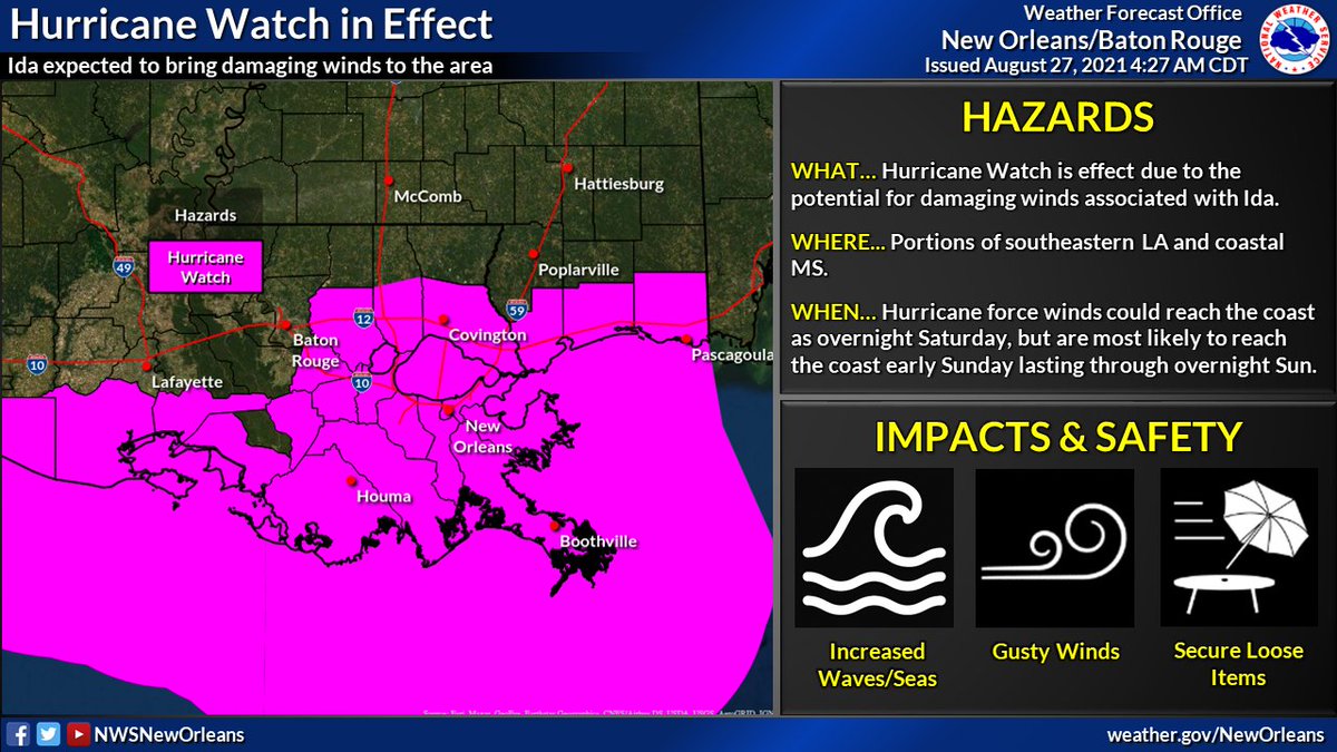
🌀 As we gear up for the potential impacts from TD9 which could be #Ida later today or tonight there are a few thing we would like everyone to understand and be prepared for. #LAwx #MSwx Image
💆 DO NOT PANIC! Be prepared, stay up to date, and try to remain calm. You have time IF you begin today. If the track continues as forecast, conditions will likely begin to go downhill late Saturday. This gives you today, Friday, & even early Saturday. #LAwx #MSwx Image
Make sure you get your information from reliable sources. Federal sources are @NWS @NWSLakeCharles @NWSJacksonMS @NWSShreveport @NWSMobile @NWSHouston @NHC_Atlantic @NWSWPC @NWSSPC @fema @femaregion4 @FEMARegion6 #LAwx #MSwx ImageImage
📺 📻 Other reliable resources is any of the local and national media meteorologist. We have 3 media markets in our area Baton Rouge, Coastal MS, & New Orleans. We also have 4 others that cover the outskirts of our area. Alexandria, Jackson MS, Lafayette, and Mobile AL. Image
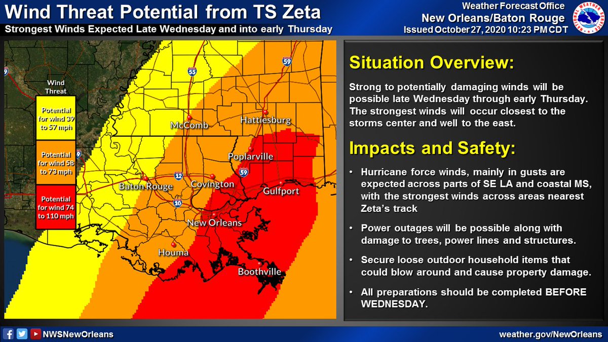
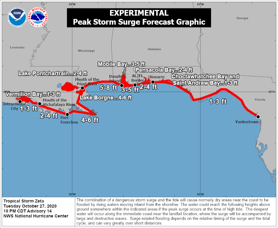
🌀 Even if you were here for Hurricane Zeta, you have NOT gone through a Category 3 hurricane. Yes Zeta was upgraded to a Cat 3 at landfall but those winds were confined to a very small section of the immediate coast. Most only experienced strong Tropical Storm to high end Cat 1. ImageImage
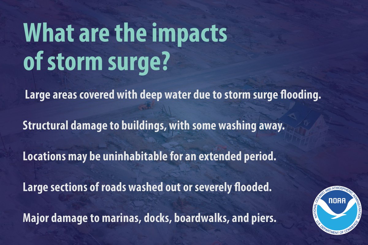
🌀 Understand every storm is different. You may have gone through numerous but each storm has different impacts. Isaac may have "only" been a Cat 1 but surge was historic in some areas. Rita brought us tornadoes and surge, Gustav brought wind. Don't rely on previous experiences Image

• • •

Missing some Tweet in this thread? You can try to force a refresh
 

Keep Current with NWS New Orleans

NWS New Orleans Profile picture

Stay in touch and get notified when new unrolls are available from this author!

Read all threads

This Thread may be Removed Anytime!

PDF

Twitter may remove this content at anytime! Save it as PDF for later use!

Try unrolling a thread yourself!

how to unroll video
  1. Follow @ThreadReaderApp to mention us!

  2. From a Twitter thread mention us with a keyword "unroll"
@threadreaderapp unroll

Practice here first or read more on our help page!

More from @NWSNewOrleans

28 Aug
There is some confusion surrounding the impacts that will occur across our area. Here is a breakdown of all the impacts we are expecting from Hurricane #Ida below by area/region. #Ida is a dangerous hurricane and it WILL produce LIFE-THREATENING impacts. #mswx #lawx
For the Baton Rouge metro area: Expect winds >110mph sustained. Rainfall 10-15” with 20”+ possible. Brief tornadoes possible. #lawx
For the River Parishes: Expect winds >110mph sustained. Rainfall 10-15” with 20”+ possible. Brief tornadoes possible. 5-8 ft of inundation in Lake Pontchartrain. #lawx
Read 9 tweets
28 Aug
We continue to monitor Ida as it approaches, expected to make landfall Sunday afternoon/evening. A hurricane Warning is in effect for areas of southern/central LA. A Tropical Storm Warning is in effect for parts of coastal/southern MS and western LA. #LAwx #MSwx
We want to continue to stress that this WILL be a DANGEROUS and LIFE-THREATENING storm. There WILL be significant wind damage. Prepare for widespread power outages and tree/structural damage in these purple/red areas on the graphic below.
Hurricane Ida is expected to deliver LIFE-THREATENING Flash Flooding for portions of Louisiana and coastal MS. 8-16 inches of rainfall is possible and a Flash Flood Watch is in effect due to this.
Read 6 tweets
27 Aug
🌀 4AM CT Tropical Storm Ida Thread: Ida continues northwest south of Cuba, expected to enter into the SE Gulf tonight/early Saturday. Ida remains on track to become a major hurricane, delivering significant impacts to portions of southern LA and southern MS. #lawx #mswx (1/5)
🍃 A Hurricane Watch is in effect for portions of southeastern LA, coastal MS and adjacent marine areas. Damaging winds will be possible beginning overnight Saturday along the coast, spreading inland into Sunday. #lawx #mswx (2/5)
🌊 A Storm Surge Watch is in effect for the potential of life-threatening storm surge along the coast of southeastern Louisiana and coastal Mississippi. Inundation could begin as early as late Saturday. #lawx #mswx (3/5)
Read 5 tweets
28 Oct 20
🌀10PM CDT Update on Tropical Storm #Zeta. Starting to see some steady strengthening trend now with max winds at 70mph. Impacts across parts of SE LA and southern MS remain likely on Wednesday.

Lets break down each specific threat one at a time...(1/6)
1. 💨 Wind: Strong winds will be the primary threat when #Zeta makes landfall. These winds may lead to isolated to scattered power outages, some tree damage and even some damage to some structures - especially near the center of the track. (2/6) #lawx #mswx
2. 🌊 Storm Surge: Moderate/major coastal flooding is possible in the Storm Surge Warning areas. Highest water levels are expected during the high tide cycle Wednesday, lasting into the overnight hours before water levels come back down Thursday. (3/6) #lawx #mswx #Zeta
Read 6 tweets
27 Oct 20
(1/6) 🌀 7PM CDT Update on Hurricane #Zeta. No major changes this evening as #Zeta continues towards the NW with an eventual, brief landfall expected across the Yucatan later tonight. We are still anticipating impacts, some major across the area Wed & Thu. Stay tuned! #lawx #mswx
(2/6) Hurricane and Tropical Storm Watches remain in effect for a large portion of SE LA and coastal MS. Strong, potentially damaging winds may be possible in association with #Zeta late Wednesday through early Thursday. #lawx #mswx
(3/6) Storm Surge Watches remain in effect all across coastal SE LA and coastal Mississippi including portions of the Tidal Lakes. Minor inundation may begin as early as Tuesday, with rising levels primarily during high tide cycles through Wednesday and early Thursday #lawx #mswx
Read 6 tweets
8 Oct 20
🌀 (1/5): Here's the latest with Hurricane #Delta as of 10AM CDT. Some slight strengthening was noted by recent aircraft recon observations with a steady strengthening trend now expected through the day today. Impacts still remain likely across our area Friday. #lawx #mswx
💨(2/5): No changes to the Tropical Storm Watches and Warnings that remain in effect. Expect winds to increase across coastal areas of SE LA later today/tonight, and spread inland during the day on Friday. #lawx #mswx
💧 (3/5) Locally heavy rainfall remains likely - with the greatest threat for flash flooding west of I-55 where a Flash Flood Watch remains in effect through Saturday afternoon. #lawx #mswx
Read 5 tweets

Did Thread Reader help you today?

Support us! We are indie developers!


This site is made by just two indie developers on a laptop doing marketing, support and development! Read more about the story.

Become a Premium Member ($3/month or $30/year) and get exclusive features!

Become Premium

Too expensive? Make a small donation by buying us coffee ($5) or help with server cost ($10)

Donate via Paypal Become our Patreon

Thank you for your support!

Follow Us on Twitter!

:(