(1/6) πŸŒ€ 7PM CDT Update on Hurricane #Zeta. No major changes this evening as #Zeta continues towards the NW with an eventual, brief landfall expected across the Yucatan later tonight. We are still anticipating impacts, some major across the area Wed & Thu. Stay tuned! #lawx #mswx
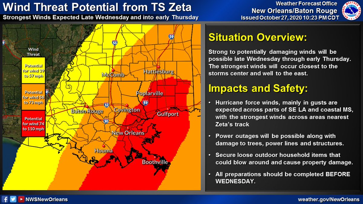
(2/6) Hurricane and Tropical Storm Watches remain in effect for a large portion of SE LA and coastal MS. Strong, potentially damaging winds may be possible in association with #Zeta late Wednesday through early Thursday. #lawx #mswx
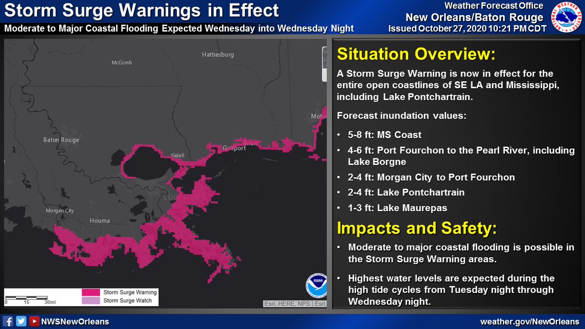
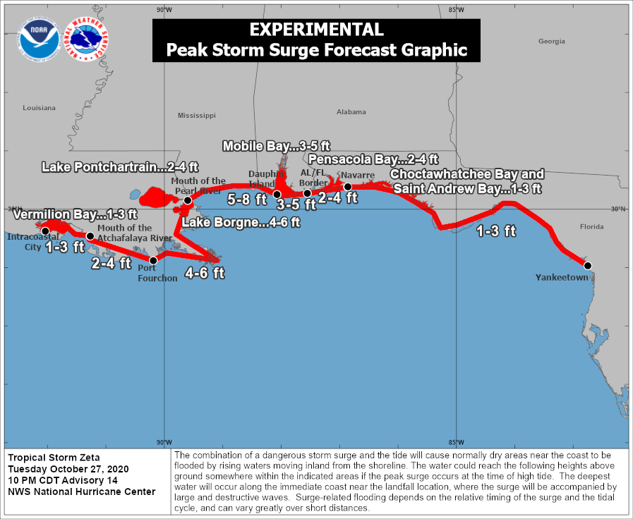
(3/6) Storm Surge Watches remain in effect all across coastal SE LA and coastal Mississippi including portions of the Tidal Lakes. Minor inundation may begin as early as Tuesday, with rising levels primarily during high tide cycles through Wednesday and early Thursday #lawx #mswx
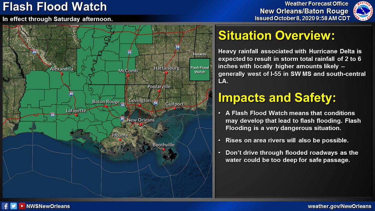
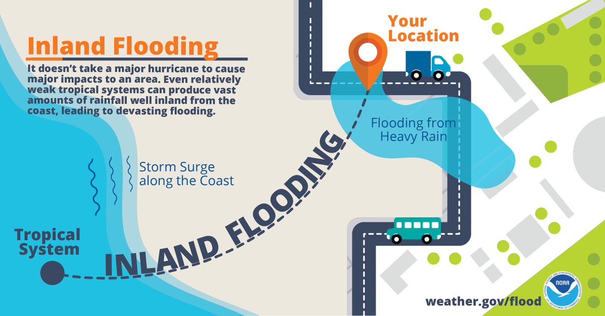
(4/6) Heavy rainfall leading to flash flooding will be possible along and to the east of the storm's track. Total rainfall of around 2 to 6 inches will be possible, with locally higher amounts depending where heavier rain bands set up (mainly across coastal MS) #lawx #mswx
(5/6) A few isolated, brief tornadoes will be possible to the northeast and east of the storms track late Wednesday and into early Thursday. Make sure you have a reliable way to receive warnings should they become necessary.#lawx #mswx
(6/6) Key Messages: Make sure you have a reliable plan in place BEFORE WEDNESDAY if you are in the hurricane or tropical storm watches currently in effect (this includes areas E to the FL panhandle). Keep your kit up to date, and stay vigilant to any potential changes #lawx #mswx

β€’ β€’ β€’

Missing some Tweet in this thread? You can try to force a refresh
γ€€

Keep Current with NWS New Orleans

NWS New Orleans Profile picture

Stay in touch and get notified when new unrolls are available from this author!

Read all threads

This Thread may be Removed Anytime!

PDF

Twitter may remove this content at anytime! Save it as PDF for later use!

Try unrolling a thread yourself!

how to unroll video
  1. Follow @ThreadReaderApp to mention us!

  2. From a Twitter thread mention us with a keyword "unroll"
@threadreaderapp unroll

Practice here first or read more on our help page!

More from @NWSNewOrleans

28 Oct
πŸŒ€10PM CDT Update on Tropical Storm #Zeta. Starting to see some steady strengthening trend now with max winds at 70mph. Impacts across parts of SE LA and southern MS remain likely on Wednesday.

Lets break down each specific threat one at a time...(1/6) Image
1. πŸ’¨ Wind: Strong winds will be the primary threat when #Zeta makes landfall. These winds may lead to isolated to scattered power outages, some tree damage and even some damage to some structures - especially near the center of the track. (2/6) #lawx #mswx ImageImageImage
2. 🌊 Storm Surge: Moderate/major coastal flooding is possible in the Storm Surge Warning areas. Highest water levels are expected during the high tide cycle Wednesday, lasting into the overnight hours before water levels come back down Thursday. (3/6) #lawx #mswx #Zeta ImageImageImage
Read 6 tweets
8 Oct
πŸŒ€ (1/5): Here's the latest with Hurricane #Delta as of 10AM CDT. Some slight strengthening was noted by recent aircraft recon observations with a steady strengthening trend now expected through the day today. Impacts still remain likely across our area Friday. #lawx #mswx
πŸ’¨(2/5): No changes to the Tropical Storm Watches and Warnings that remain in effect. Expect winds to increase across coastal areas of SE LA later today/tonight, and spread inland during the day on Friday. #lawx #mswx
πŸ’§ (3/5) Locally heavy rainfall remains likely - with the greatest threat for flash flooding west of I-55 where a Flash Flood Watch remains in effect through Saturday afternoon. #lawx #mswx
Read 5 tweets
8 Oct
Here is the 4AM update on Hurricane #Delta along with a thread on the latest local hazards expected from Hurricane #Delta.

Delta will bring potential for:
🌊Life-threatening storm surge flooding
🌬️Damaging winds
β›ˆοΈHeavy rain and flash flooding

#lawx #mswx
(1/5)
Locally, the strongest winds from #Delta are expected across areas nearest the Atchafalaya River.

Strong winds could result in:
πŸ”ŒPower outages
🌳Minor to moderate damage to trees/power lines
🏠Damage to a few structures from falling branches/trees

#lawx #mswx
(2/5)
Life-threatening storm surge from #Delta will be possible across coastal areas of SE LA and MS.

Low lying roads could become flooded and some areas could become cut off in the most vulnerable areas.

If an evacuation order is issued by local officials, leave!

#lawx #mswx
(3/5)
Read 5 tweets
8 Oct
Here's a thread on the latest local hazards expected from Hurricane #Delta.

Delta will bring potential for:
🌊 Life-threatening storm surge flooding
🌬️ Damaging winds
🌧️ Heavy rain and flash flooding

#lawx #mswx
(1/5) Delta will bring potential for life-threatening storm surge
Locally, the strongest winds from #Delta are expected across areas nearest the Atchafalaya River.

Strong winds could result in:
πŸ”Œ power outages
🌳 minor to moderate damage to trees/power lines
🏠 damage to a few structures from falling branches/trees

#lawx #mswx
(2/5) Strong to potentially damaging winds will be possible Friday
Life-threatening storm surge fro m#Delta will be possible across coastal areas of SE LA & MS.

Low lying roads could become flooded & some areas could become cut off in the most vulnerable areas.

If an evacuation order is issued by local officials, leave!

#lawx #mswx
(3/5) Peak inundation levels could reach: * 7 to 11 ft west of Por
Read 5 tweets
7 Oct
πŸŒ€ (1/6): Tweet thread with the latest on Hurricane #Delta. The 10AM position has #Delta continuing to cross the Yucatan & will emerge into the Gulf later today. No major changes to the forecast track as impacts, some significant, may be likely later this week/weekend #lawx #mswx
πŸŒ€ (2/6) Tropical Storm and Hurricane Watches are now in effect for portions of SE LA and S MS. Expect gusty winds to increase across the area late Thursday and into Friday - lasting into early Saturday. #lawx #mswx
πŸŒ€ (3/6) Storm Surge Watches are now in effect for all coastal areas of SE LA and S MS. Expect coastal flooding from storm surge to begin as early as Thurs night across these areas. Have preparations IN PLACE before THURSDAY if you live in a storm surge prone location #lawx #mswx
Read 6 tweets
6 Oct
πŸŒ€ (1/3) 10AM CDT Update on TS #Delta: Delta is now a major hurricane in the west-central Caribbean. No major changes to the forecast track as impacts remain likely along the northern Gulf coast late this week and this weekend. #lawx #mswx Image
πŸŒ€ (2/3) As a reminder, NOW is the time to have a plan! Don't let the recent cool temperatures fool you - it is still Hurricane Season! Impacts remain likely with this system across portions of the northern Gulf coast and you should take it seriously! #lawx #mswx ImageImageImage
πŸŒ€ (3/3) Do you know which NWS office serves your area? Our neighbors include @NWSLakeCharles to our west including SW LA, @NWSJacksonMS to the north across most of MS, & @NWSMobile to our E including the AL/FL beaches. Follow your local office for the latest updates! #lawx #mswx Image
Read 4 tweets

Did Thread Reader help you today?

Support us! We are indie developers!


This site is made by just two indie developers on a laptop doing marketing, support and development! Read more about the story.

Become a Premium Member ($3/month or $30/year) and get exclusive features!

Become Premium

Too expensive? Make a small donation by buying us coffee ($5) or help with server cost ($10)

Donate via Paypal Become our Patreon

Thank you for your support!

Follow Us on Twitter!