As we start a new week, let's check in to see what's on the menu down in the tropics.
-#Larry recurves into the North Atlantic, perhaps brushing NL.
-#91L may still develop but probably not until it moves east of FL.
-New Caribbean wave to watch.
-Maybe a new EATL storm.
Right now, of the three storms that have yet to develop, the new Caribbean system probably deserves the most scrutiny.
It will form in a manner similar to Ida and 91L, which means it could either become an impactful storm or wander west into Central America.
#91L isn't looking too hot this morning given the wind shear and dry air we've been talking about for several days.
We'll watch to see if any circulation might be able to form under the deeper convection that has been popping up this morning due west of Key West.
#91L's forward speed is much less certain than its general track, which will be set by a trough digging through the Central US.
It's now pretty clear 91L is headed ENE over Florida into the Atlantic, just dunno how fast.
If it develops, low-mod TS still seems like the ceiling.
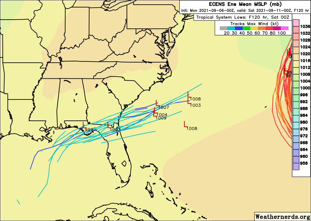
Out in the far eastern Atlantic, ECMWF/EPS forecasts showing development of a closed tropical cyclone over Mauritania are the result of a pretty well-known bias in the model leading to erroneous TCG over land.
GEFS forecast of quick development offshore is much more realistic.
• • •
Missing some Tweet in this thread? You can try to
force a refresh
There are a whole lot of houses that shouldn’t exist in Florida (and elsewhere!) and the sad fact is a tremendous number of them are about to be rebuilt on taxpayers’ dime through NFIP.
The storm is really starting to feel the squeeze between new cells encroaching from the south and the broader line of storms approaching from the west.
It's still dangerous and in a dangerous environment, but I think its time of unrivaled dominance is running out.
Indeed, the latest scan shows higher CC values (though still enough of a drop to be considered a TDS IMO), a weaker/broader couplet, and a lack of a clearly-defined reflectivity hook.
It's still dangerous, but it's no longer in tip top shape.
The storm has been tornado-warned for approximately 5 hours (first mention by me:
Still nothing standing in the way of this supercell producing a strong to violent tornado for the forseeable future, though low-level instability starts waning a bit as you approach the I-69 corridor.
Either way, if you're in the storm's path (even if not warned yet), be ready.
SPC is clearly on the same page with a new MD saying that this storm could remain at or near this intensity (producing a strong to violent tornado) for *at least* another HOUR #KYwx
I’m never going to be perfect but I try very hard to respond to and improve from criticism.
Neither outlet I mentioned in my earlier tweet has ever made even cursory gestures in that direction, hence the rather harsh approach in dealing with them.
I definitely don’t want my initial tweet to be interpreted as “HS kids in their parents basement are the problem” as someone who has done (and is still doing! And will still be doing until May!) a lot of tweeting without the requisite degrees.
As we're in peak Hurricane Season and the tropical Atlantic remains active, here's a quick reminder to make sure you're tuned into reliable sources (first and foremost @NHC_Atlantic) and tuned out of the cacophony of misinformation.
Here's some BS I've been asked about today:
@NHC_Atlantic Both of these outlets are well-known purveyors of misinformation about tropical cyclones. If you're following them, I suggest the unfollow button.
If friends/family ask you about their posts, I'd make the same suggestion.
@NHC_Atlantic Remember:
-ONLY the NHC makes determinations about what category a storm is, and anyone claiming to do so is leading you astray.
-NO long range (7-10day+) deterministic model forecast is worth posting or getting concerned about.
Winds still steady at 105mph as the pressure falls to 964mb.
Satellite presentation continues to improve, but we'll have to wait until the next recon plane arrives in a few hours to see whether that's translating to stronger winds.
Winds haven't come up as much as anticipated today, due largely to some lingering chaos in the inner core after Cuba.
But the storm has picked up tons of energy, dropping its central pressure by >20mb and pushing hurricane force winds dozens of miles from the center.
All environmental and satellite indicators continue to point towards rapid intensification tonight.
That's what folks should expect and plan on.
Regardless of what max winds a few spots see in the eyewall, surge and rain will be catastrophic.