Local Weather 1) rain is likely the next couple of days with a general 1-3 inches for many. Some areas of the foothills/NW piedmont and SE NC could see 3-5 inches of rain locally.
2) After the front passes Wed night/Thurs am we see a dry, less humid and cooler weather pattern. Morning lows will be in the 40s in the west and low 50s in the Triangle Friday/Saturday with highs in the mid 70s. Sunday looks nice as well making a wonderful weather weekend.
3) Next week temps warm a bit back into the upper 70s to low 80s. Rain chances remain low but could increase slightly for mid week.
4) In general much of the country will be above normal as we start October. However, the Southeast will likely be the relative cool spot with temps near normal for early Oct. Which for our area is mid to upper 70s for highs, mid 50s for lows.

• • •

Missing some Tweet in this thread? You can try to force a refresh
 

Keep Current with Allan Huffman

Allan Huffman Profile picture

Stay in touch and get notified when new unrolls are available from this author!

Read all threads

This Thread may be Removed Anytime!

PDF

Twitter may remove this content at anytime! Save it as PDF for later use!

Try unrolling a thread yourself!

how to unroll video
  1. Follow @ThreadReaderApp to mention us!

  2. From a Twitter thread mention us with a keyword "unroll"
@threadreaderapp unroll

Practice here first or read more on our help page!

More from @RaleighWx

2 Aug 20
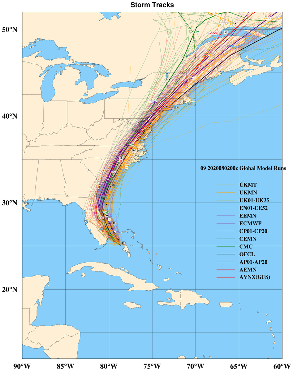
Here are the major 00z global models and their ensembles. #Isaias will likely stay just off the SE FL coast, although a brief landfall of the center still cant be ruled out. I think landfall will likely be between Cape Romain SC and Cape Fear, NC. I have shifted my track (1/4)
a bit west with landfall of #Isaias near the NC/SC border, I am still a bit NE of the model consensus at the moment. With a track up the NC coastal plain, Tidewater/Delmarva/NE Coast. It does looks more likely that the center will stay mostly onshore on its ride NE. (2/4)
As far as intensity. #Isaias has not been a easy storm to forecast intensity wise. I would imagine little strengthening today as it is close to the coast. There could be a window to re-attain cat 1 strength tomorrow over the ocean before landfall Monday night. (3/4)
Read 4 tweets
30 Jul 20
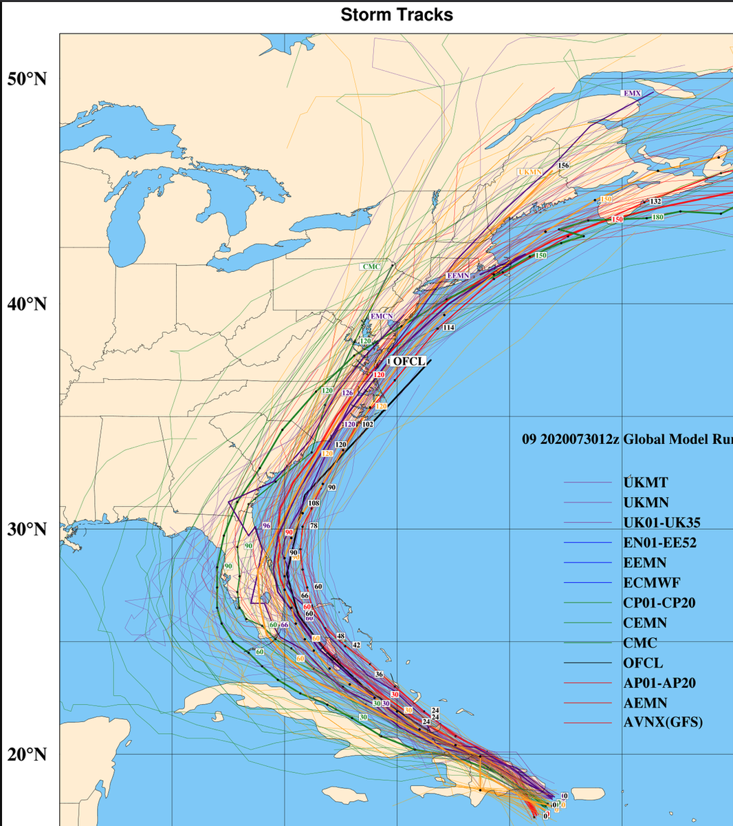
So there has certainly been some convergence on the track forecast today for #Isaias The 12z major global models and their ensembles. It looks like the storm will strengthen into a hurricane as it moves through the Bahamas and towards Florida. I could see cat 1, maybe cat 2.(1/4)
in a high end scenario Some increasing vertical shear could limit intensification or weaken #Isaias this weekend as it moves up just off the FL coast. I like a track just off the GA/SC coast with a threat to the NC coast by Mon/Tues The waters are warm so we could (2/4)
see some re-intensification. The steering currents look to keep #Isaias close to the coast as it re-curves so interests along the whole east coast need to monitor and prepare. This is my best idea as of now. But, I would like to see the storm pull away from Hispaniola .. (3/4)
Read 4 tweets

Did Thread Reader help you today?

Support us! We are indie developers!


This site is made by just two indie developers on a laptop doing marketing, support and development! Read more about the story.

Become a Premium Member ($3/month or $30/year) and get exclusive features!

Become Premium

Too expensive? Make a small donation by buying us coffee ($5) or help with server cost ($10)

Donate via Paypal Become our Patreon

Thank you for your support!

Follow Us on Twitter!

:(