👀

Storm Prediction Center has increased the concern level for severe weather 👉🏽 Friday, likely late Friday night, overnight, into Saturday morning.

An 8:30 AM Thursday thread 🧵 about Hazards, Probability, Timing, & Preparedness
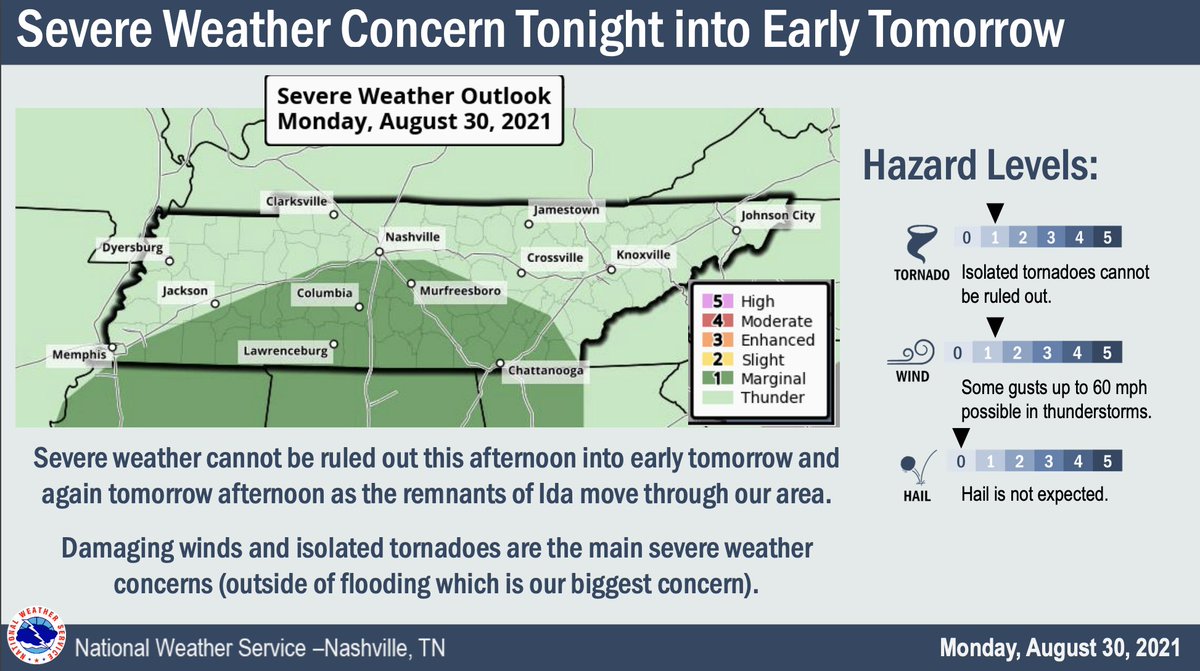
Hazards - Tornado

The probability of a tornado within 25 miles of you is 10%.

Shaded area means some tornadoes could be strong, EF-2 or stronger. We are not squarely in the middle of this strong tornado risk area, but we’re in it.
Hazards - Damaging Straight Line Winds, Flash Flooding, Large Hail

60+ MPH winds the most likely hazard (30%), flash flooding 5% to 10%, with large hail least likely (5%), within 25 miles of you.
Timing

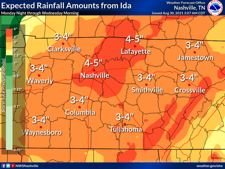
Rain should develop along a warm front that’ll move north thru Middle Tennessee during the day Friday. That activity should not be severe.
“Later Friday night into Saturday morning is when we will see the
weight of this system.” — @NWSNashville. This is when the severe weather may happen.

Timing confidence will improve a bit as high res models come in.
Get Ready

Mobile and manufactured home residents should consider spending Friday evening and night #sleepover in a site built structure.

Everyone needs a NOAA weather radio and a wake me up app (@stormwatchplus). Sirens are not designed to alert those indoors.
Clean out your lowest level interior room space. Have helmets (mandatory for kids IMO) and shoes and essential meds and driver’s license and a whistle.

New to tornado weather? 👇🏽

nashvillesevereweather.com/what-to-do/
Now, that you’re prepared, good job. This is a low probability of a high impact event that requires your time (to prepare), attention (to watches or warnings), and action (if a warning is issued).

Got storm anxiety? 👇🏽 nashvillesevereweather.com/storm-anxiety/
Expect this forecast to change a bit. Do not rely on old information. Stay updated and get new information.

We will be with you the entire way.

• • •

Missing some Tweet in this thread? You can try to force a refresh
 

Keep Current with NashSevereWx

NashSevereWx Profile picture

Stay in touch and get notified when new unrolls are available from this author!

Read all threads

This Thread may be Removed Anytime!

PDF

Twitter may remove this content at anytime! Save it as PDF for later use!

Try unrolling a thread yourself!

how to unroll video
  1. Follow @ThreadReaderApp to mention us!

  2. From a Twitter thread mention us with a keyword "unroll"
@threadreaderapp unroll

Practice here first or read more on our help page!

More from @NashSevereWx

8 Dec
No cause for party or panic but behold the appearance of "snowshowers" in the forecast grid in the predawn hours Wednesday (cough, tomorrow) morning. 1/4 Image
[insert your reply to the above tweet with an "other people will rush to the store and buy bread and milk" jokes, go ahead, you know you want to, they are always funny] 2/4
But seriously, "only trace amounts" seen in the models. There. Are. No. Concerns. Nothing gonna happen to alter your plans tomorrow although low key that would be great, I got to see the dentist at 8 AM and I'd rather not.

Also, look who's back! #NotoriousDAM 3/4 Image
Read 4 tweets
30 Aug
Rainfall amounts through Wednesday morning could be 4-5 inches with isolated higher amounts to 6 inches possible. Make sure gutters and storm drains are clear so water can go where it's supposed to. Have a way to get flash flood warnings that'll wake you up. ^al (1/5)
A Flash Flood Watch is in effect from 7:00 pm tonight through 1:00 am Wednesday Morning. ^al (2/5)
The tornado threat is mostly concentrated S of I-40 where there is a 2% chance of a tornado within 25 miles of you. These are often hard to warn, quick spin-ups with tropical systems. If a tornado warning is issued, you may not have much time to act. Have a plan. ^al (3/5)
Read 5 tweets
17 Mar
Morning Update. All timing subject to change.

1/10

1. Storms are now lifting out of north MS and north AL.
2. The 11z run of HRRR model shows most of these storms will continue to move north, the bigger ones hitting west TN, during late morning/lunch. We will see rain late morning/lunchtime.

Then around 4-5 PM a line of stronger storms moves in.
3. Forecast soundings for both the lunch time and mid/late afternoon storms are not concerning. Dewpoints upper 50s, a surface inversion, and very little instability are all encouraging. Shear will be substantial, though, so any storm that can find instability could rotate.
Read 10 tweets
11 Feb
Davidson & Williamson Counties cover 1,110 sq. mi. Will Co's highest elevation is 1256 feet, Davidson's is 1160 feet. Temps vary by elevation. Roads go up and down hills. Some are shaded, some runoff water well. Where ice has formed, or may form, is as diverse as our community...
...therefore we know no specifics. General rules are helpful but not decisive. Wind helps dry roads. Roads at elevation are colder, but they got gravity on their side, water can run off. Treated roads will hold less ice than untreated roads. It appears...
...we avoided a legit ice storm by about 2° to 4° in most places. Any standing water or existing ice that hasn't melted this afternoon should remain icy overnight as temps everywhere drop below freezing. Check Waze, Google Maps, for the OK before undertaking a route...
Read 8 tweets
10 Feb
Remember in the summer, when it can be pouring down the street, but dry at your place? Same kinda thing incoming overnight about temps. Temp will be influenced by elevation and location: 34°, 33°, 32°, 31°, 30° will be scattered across our county. The average temp freezing line..
...is expected to bisect Davidson and Williamson Counties. Note that we need 31° and 30° temps for a long time to cause ice accretion, but the problem is there is no indication where the hazards are. Icy roads will look wet, and wet roads will look icy. You can keep an eye on ..
.. personal weather station surface temperatures here (wrh.noaa.gov/map/?&zoom=8&s…) early Thursday morning. Note not all those stations are calibrated. Fun, isn't it? ...
Read 5 tweets
9 Aug 20
Today I read about Space Threats. Because 2020.

I was cleaning bookmarks. Came across weather.gov/safety/ National Weather Service Safety Tips.

You got Floods (ya), Lightning (nodding), Tornadoes, Hurricanes, etc. Feed me those tips.

But what was this? 1/12
Safety Tips for Space Weather? Um, is space threatening us?

I clicked the link hoping for tips about alien invasion (everyone dress like a stormtrooper), space thunderstorms (beam/teleport to alternate hemisphere), asteroids (Roman Josi slap shot)?

2/
Instead the first thing you see are space weather victims

untethered space-exploring astronaut,
comically large satellite,
communications (gulp),
GPS (ruh),
aviation (roh),
electric power (ruh roh),

and the northern lights.

How, exactly? 3/
Read 12 tweets

Did Thread Reader help you today?

Support us! We are indie developers!


This site is made by just two indie developers on a laptop doing marketing, support and development! Read more about the story.

Become a Premium Member ($3/month or $30/year) and get exclusive features!

Become Premium

Too expensive? Make a small donation by buying us coffee ($5) or help with server cost ($10)

Donate via Paypal

Or Donate anonymously using crypto!

Ethereum

0xfe58350B80634f60Fa6Dc149a72b4DFbc17D341E copy

Bitcoin

3ATGMxNzCUFzxpMCHL5sWSt4DVtS8UqXpi copy

Thank you for your support!

Follow Us on Twitter!

:(