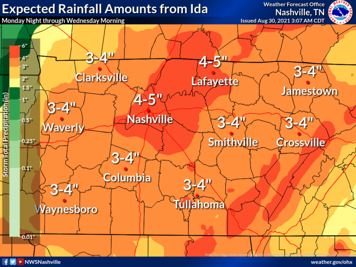
Rainfall amounts through Wednesday morning could be 4-5 inches with isolated higher amounts to 6 inches possible. Make sure gutters and storm drains are clear so water can go where it's supposed to. Have a way to get flash flood warnings that'll wake you up. ^al (1/5)
A Flash Flood Watch is in effect from 7:00 pm tonight through 1:00 am Wednesday Morning. ^al (2/5)
The tornado threat is mostly concentrated S of I-40 where there is a 2% chance of a tornado within 25 miles of you. These are often hard to warn, quick spin-ups with tropical systems. If a tornado warning is issued, you may not have much time to act. Have a plan. ^al (3/5)
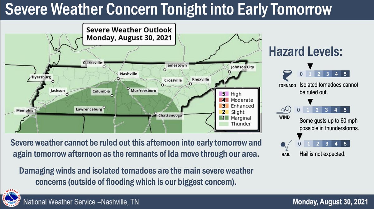
Wind: While we could see damaging wind gusts associated with thunderstorms, NWS is not forecasting general wind gusts outside of thunderstorms to be a problem. 20-25 mph wind gusts aren't that unusual around here. (4/5)
How to prepare: 1) Make sure you have at least two ways to get warnings...a wake-me-up app like @stormwatchplus and NOAA Weather Radio. 2) Have a plan for if a flash flood or tornado warning is issued. 3) Make sure storm drains near your home are clear. ^al (5/5)
• • •
Missing some Tweet in this thread? You can try to
force a refresh
1. Storms are now lifting out of north MS and north AL.
2. The 11z run of HRRR model shows most of these storms will continue to move north, the bigger ones hitting west TN, during late morning/lunch. We will see rain late morning/lunchtime.
Then around 4-5 PM a line of stronger storms moves in.
3. Forecast soundings for both the lunch time and mid/late afternoon storms are not concerning. Dewpoints upper 50s, a surface inversion, and very little instability are all encouraging. Shear will be substantial, though, so any storm that can find instability could rotate.
Davidson & Williamson Counties cover 1,110 sq. mi. Will Co's highest elevation is 1256 feet, Davidson's is 1160 feet. Temps vary by elevation. Roads go up and down hills. Some are shaded, some runoff water well. Where ice has formed, or may form, is as diverse as our community...
...therefore we know no specifics. General rules are helpful but not decisive. Wind helps dry roads. Roads at elevation are colder, but they got gravity on their side, water can run off. Treated roads will hold less ice than untreated roads. It appears...
...we avoided a legit ice storm by about 2° to 4° in most places. Any standing water or existing ice that hasn't melted this afternoon should remain icy overnight as temps everywhere drop below freezing. Check Waze, Google Maps, for the OK before undertaking a route...
Remember in the summer, when it can be pouring down the street, but dry at your place? Same kinda thing incoming overnight about temps. Temp will be influenced by elevation and location: 34°, 33°, 32°, 31°, 30° will be scattered across our county. The average temp freezing line..
...is expected to bisect Davidson and Williamson Counties. Note that we need 31° and 30° temps for a long time to cause ice accretion, but the problem is there is no indication where the hazards are. Icy roads will look wet, and wet roads will look icy. You can keep an eye on ..
.. personal weather station surface temperatures here (wrh.noaa.gov/map/?&zoom=8&s…) early Thursday morning. Note not all those stations are calibrated. Fun, isn't it? ...
I was cleaning bookmarks. Came across weather.gov/safety/ National Weather Service Safety Tips.
You got Floods (ya), Lightning (nodding), Tornadoes, Hurricanes, etc. Feed me those tips.
But what was this? 1/12
Safety Tips for Space Weather? Um, is space threatening us?
I clicked the link hoping for tips about alien invasion (everyone dress like a stormtrooper), space thunderstorms (beam/teleport to alternate hemisphere), asteroids (Roman Josi slap shot)?
2/
Instead the first thing you see are space weather victims
untethered space-exploring astronaut,
comically large satellite,
communications (gulp),
GPS (ruh),
aviation (roh),
electric power (ruh roh),
Technical forecast discussion from @NWSNashville just posted, describing several factors that could reduce or supplement 0.5" to 1" expected tomorrow. I hereby attempt to unpack it. A thread 1/
2/ Some models think surface temps will drop only into the mid 30s, then stop there. Splat/Melt would "dramatically cut snow totals."
3/ However, other data shows dry air aloft that, once the Dry Air Monster (D.A.M.) is fed, will lower surface temps ~ freezing. When the D.A.M. eats, the air around him cools. This is called "evaporative cooling," or if you're a cool scientist, "wet bulbing" to freezing.
Storm Update! 1 of 7. Two rounds (really, just one) of storms tomorrow.
ROUND ONE: fizzles shortly after midnight. HRRR model shows strong storms now in west Tennessee, but as they get to us in the pre-dawn hours tomorrow morning, they dissolve into weaksauce, no big deal.
2 of 7. The Euro model agrees, Round 1 of storms fizzles like an ice cube in boiling water. Even the NAM3 model agrees, ⬇️.
3 of 7. This is why the Storm Prediction Center keeps us out of its severe weather outlook through 7 AM. Round 1: meh.
Winds strong all day Thu, gusting up to 45 MPH. Secure loose objects and lightweight loved ones. Parking under trees is risky. Winds will LOL at your umbrella.