Looks like rain Saturday with a transition to wintry mix or snow late Saturday into Sunday. Forecast is a headache…. Rain, sleet and snow are all possible between Saturday and Sunday night with travel impacts potentially extending beyond that. (1/6) ^al
NWS: “Get ready for winter weather and possible major travel impacts, but understand these winter storms are difficult to predict and change rapidly. Even small changes in the strength and track can mean huge changes in real-world impacts.” (2/6) ^al
Challenge 1 - precip type. The track of this system is critical as is the exact temperature profile above our heads. More sleet cuts way down on snow totals. (3/6) ^al
Challenge 2 - Amounts. If the system produces snow for us, there would prob be a wide range of amts due to what’s called a “deformation zone.” This zone is what produces swaths of prolonged heavier snowfall over a relatively narrow area. It remains elusive for this wknd (4/6) ^al
The picture will likely become more clear tomorrow, but understand changes to the forecast are likely even up to the event. Once the system exits, anything we get should begin melting Monday and each day beyond with temps above freezing. (5/6) ^al
Stay connected. Stay flexible. Stay wary of recency bias that would suggest the last two events were slam dunks, so this must be. We’ll be here with updates. (6/6) ^al
• • •
Missing some Tweet in this thread? You can try to
force a refresh
Forecast is cold rain Saturday. Then Saturday night we see a changeover to wintry precip, then snow into Sunday until around dark.
This is not a universally agreed upon snow event (see below), most data thinks snow is coming so it was time for a Winter Storm Watch.
1/8
"Currently forecast snowfall accumulation amounts generally ranging from 3 to 7 inches across our area . . . potential for locally higher amounts than what is currently being forecasted is certainly possible." -@NWSNashville. A "deformation zone" may form across Middle TN...
2/8
...which is an area of heavy snow, at about 1" per hour. Exactly where that sets up no one really knows, the models keep moving it.
If this deformation zone is a dart, we're one spot on the dartboard.
3/8
Storm Prediction Center has increased the concern level for severe weather 👉🏽 Friday, likely late Friday night, overnight, into Saturday morning.
An 8:30 AM Thursday thread 🧵 about Hazards, Probability, Timing, & Preparedness
Hazards - Tornado
The probability of a tornado within 25 miles of you is 10%.
Shaded area means some tornadoes could be strong, EF-2 or stronger. We are not squarely in the middle of this strong tornado risk area, but we’re in it.
Hazards - Damaging Straight Line Winds, Flash Flooding, Large Hail
60+ MPH winds the most likely hazard (30%), flash flooding 5% to 10%, with large hail least likely (5%), within 25 miles of you.
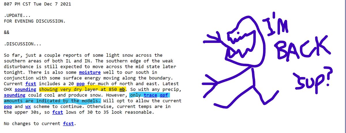
No cause for party or panic but behold the appearance of "snowshowers" in the forecast grid in the predawn hours Wednesday (cough, tomorrow) morning. 1/4
[insert your reply to the above tweet with an "other people will rush to the store and buy bread and milk" jokes, go ahead, you know you want to, they are always funny] 2/4
But seriously, "only trace amounts" seen in the models. There. Are. No. Concerns. Nothing gonna happen to alter your plans tomorrow although low key that would be great, I got to see the dentist at 8 AM and I'd rather not.
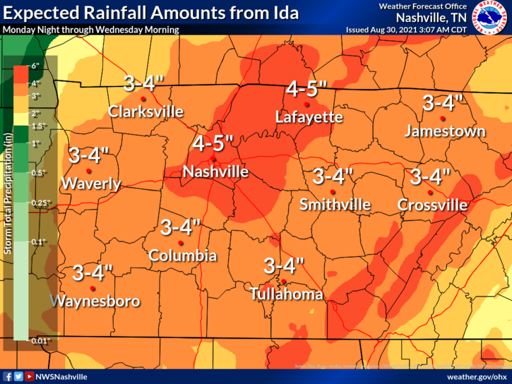
Rainfall amounts through Wednesday morning could be 4-5 inches with isolated higher amounts to 6 inches possible. Make sure gutters and storm drains are clear so water can go where it's supposed to. Have a way to get flash flood warnings that'll wake you up. ^al (1/5)
A Flash Flood Watch is in effect from 7:00 pm tonight through 1:00 am Wednesday Morning. ^al (2/5)
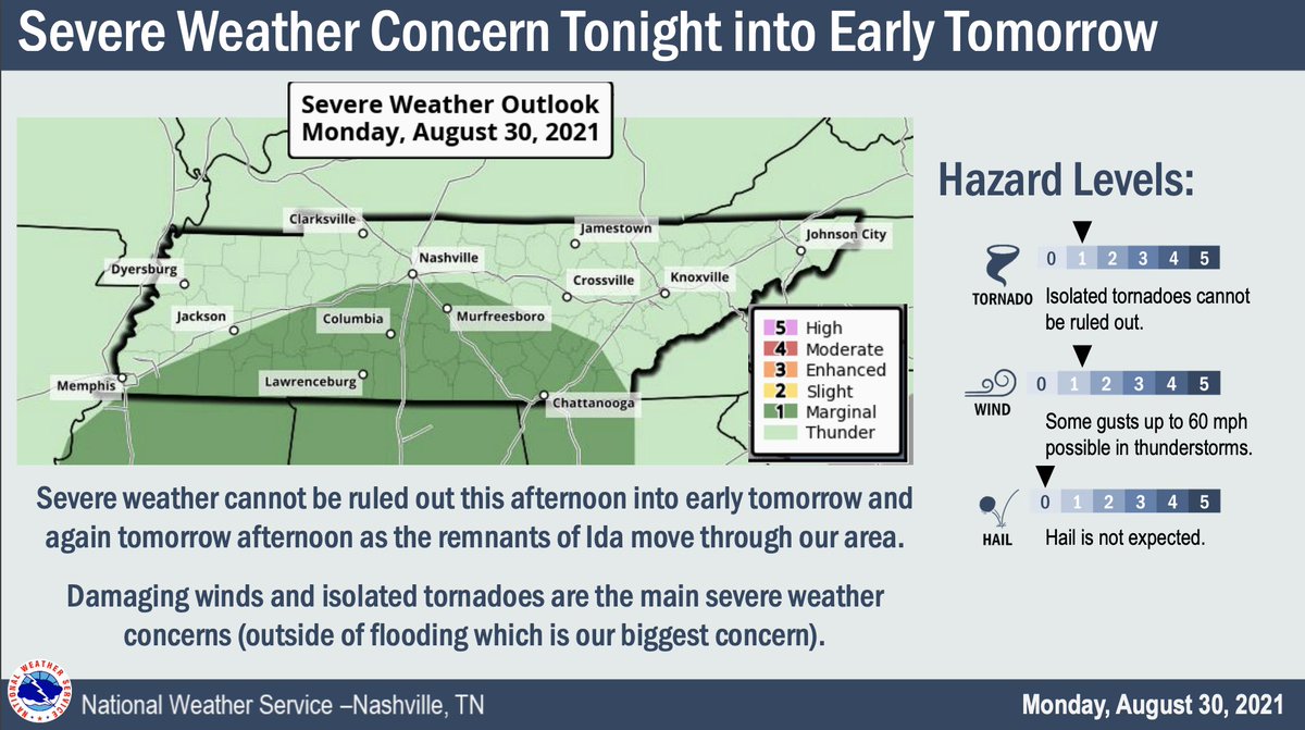
The tornado threat is mostly concentrated S of I-40 where there is a 2% chance of a tornado within 25 miles of you. These are often hard to warn, quick spin-ups with tropical systems. If a tornado warning is issued, you may not have much time to act. Have a plan. ^al (3/5)
1. Storms are now lifting out of north MS and north AL.
2. The 11z run of HRRR model shows most of these storms will continue to move north, the bigger ones hitting west TN, during late morning/lunch. We will see rain late morning/lunchtime.
Then around 4-5 PM a line of stronger storms moves in.
3. Forecast soundings for both the lunch time and mid/late afternoon storms are not concerning. Dewpoints upper 50s, a surface inversion, and very little instability are all encouraging. Shear will be substantial, though, so any storm that can find instability could rotate.
Davidson & Williamson Counties cover 1,110 sq. mi. Will Co's highest elevation is 1256 feet, Davidson's is 1160 feet. Temps vary by elevation. Roads go up and down hills. Some are shaded, some runoff water well. Where ice has formed, or may form, is as diverse as our community...
...therefore we know no specifics. General rules are helpful but not decisive. Wind helps dry roads. Roads at elevation are colder, but they got gravity on their side, water can run off. Treated roads will hold less ice than untreated roads. It appears...
...we avoided a legit ice storm by about 2° to 4° in most places. Any standing water or existing ice that hasn't melted this afternoon should remain icy overnight as temps everywhere drop below freezing. Check Waze, Google Maps, for the OK before undertaking a route...