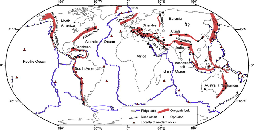
Ever look at global #earthquakes from the top down? The #NorthAmericanPlate and #EurasianPlate seem simple around the Atlantic - they're pulling apart - but if you follow that boundary across the pole to Russia, it gets weird and diffuse. 🧵1/4

#tectoplot Image
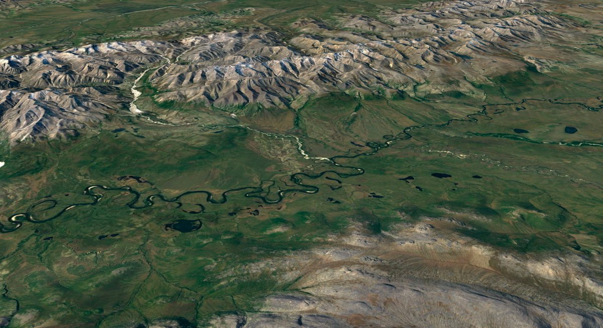
#Iceland provides a remarkable view of the plate boundary. Here, the plates are pulling apart over a #hotspot, so the spreading center is on land instead of at the bottom of the sea.

And just look at the result! Pictured here: #LakeThingvallavatn. 2/4

nationalgeographic.org/encyclopedia/r… Image
But follow that plate boundary past the pole and under the ice, and you find yourself in Russia. Suddenly the #earthquakes are scattered and the plate boundaries poorly defined.

There's actually a whole extra baby plate here - the #OkhotskPlate. 3/4

washington.edu/news/2006/05/0… Image
Because the transition happens across the polar region, it's rarely shown in tectonic maps. It's also not a very accessible region for field research. But it's an important part of the plate tectonic system, and satellite images of the area look gorgeous! Maybe someday... 4/4 Image

• • •

Missing some Tweet in this thread? You can try to force a refresh
 

Keep Current with Dr. Judith Hubbard

Dr. Judith Hubbard Profile picture

Stay in touch and get notified when new unrolls are available from this author!

Read all threads

This Thread may be Removed Anytime!

PDF

Twitter may remove this content at anytime! Save it as PDF for later use!

Try unrolling a thread yourself!

how to unroll video
  1. Follow @ThreadReaderApp to mention us!

  2. From a Twitter thread mention us with a keyword "unroll"
@threadreaderapp unroll

Practice here first or read more on our help page!

More from @JudithGeology

14 Jan
A Mw6.6 #earthquake just occurred below the W tip of #Java, #Indonesia. Here, the Indo-Australian Plate is sinking below the Sunda Plate. To the north, this #subductionzone produced the devastating Mw9.1 2004 Indian Ocean earthquake and tsunami. 🧵1/5

#tectoplot Image
Fortunately, a Mw6.6 is much, much smaller than a Mw9.1 - 5000x less energy! 2/5

earthquake.usgs.gov/education/calc…
The earthquake depth (~35-45 km) is similar to the plate boundary fault, but the focal mechanism shows slip on a steeply dipping thrust fault. This likely represents a hanging wall splay fault, or fracture of the downgoing plate. 3/5

earthquake.usgs.gov/earthquakes/ev… Image
Read 5 tweets
15 Nov 21
This is a map of sea level, exaggerated 10,000 times.

Why is it so weird and lumpy? Sea level is not defined by distance from Earth's center - it's an equal-gravity surface.

Understanding the #geoid is key to understanding #climatechange impacts. 1/7

en.wikipedia.org/wiki/Geoid Source: http://doi.org/10.5194/essd-11-647-2019.
The "lumpiness" comes from variations in density and topography. Mountains have gravity, so the #geoid is generally higher in mountainous regions. But inside the Earth there are variations, too - from the different kinds of rocks and the thickness of the crust. 2/7
Elevations on Earth are defined relative to the geoid. So every time you look at a topographic map, there's a secret geoid hidden behind that data! 3/7
Read 7 tweets
13 Nov 21
The Earth's most common elevation is sea level - and yet, most of Earth's surface lies below sea level - FAR below sea level, at 4-6 km depth.

Why?

The answer is a combination of #platetectonics and Earth's oceans. 1/9

#tectoplot ImageImage
You might think that the oceans are just parts of the land that are covered with water. Actually, that's really not the point - the oceans are there because the rocks *below* the oceans are fundamentally different from those below continents - and it's all because of magma! 2/9
Below the crust, the mantle is convecting. This is driven by heat given off by radioactive delay deep inside the Earth.

The mantle is solid rock - but every now and then a pocket melts: due to the addition of water, release of pressure, or extra added heat. Magma! 3/9 Source: https://concord.org...
Read 9 tweets
11 Oct 21
An #ophiolite is a rock with a secret: it tells the story of an ocean that lived and died.

Ophiolites are pieces of crust and mantle that formed at #spreadingcenters below an ocean. Why do we find these rocks (black dots) in mountain belts (red)? 🧵

doi.org/10.1016/j.gsf.…
The #WilsonCycle describes how tectonic plates break apart, forming an ocean basin that grows around a spreading center. But the oceanic lithosphere is dense, and it eventually breaks and sink into the mantle. #Subduction closes the basin and the plates on either side collide.
Rocks that form at a #spreadingcenter have a distinctive sequence: sediments on top, then basalts that erupted underwater, then denser rocks crystallized from melted mantle, grading into mantle. You might find this sequence on land (an #ophiolite), but it formed under the ocean.
Read 5 tweets
14 Aug 21
A catastrophic #earthquake in 2010 on this fault system in #Haiti killed ~250k people. It just ruptured again, this time to the west. Hopefully the lower population density in this region, further from Port-au-Prince, will mitigate the impact. 😧

#tectoplot #haitiearthquake
The updated focal mechanism for the earthquake from GFZ indicates the rupture was on land, and oblique thrust - similar to the overall 2010 event, which combines a mostly strike-slip mainshock with a cluster of smaller thrust earthquakes.

#tectoplot #haitiearthquake
Scattered aftershocks from the 2010 earthquake were still occurring up through this year, although none were close in magnitude to the mainshock.

#haitiearthquake
Read 6 tweets
13 Aug 21
The #SouthSandwichIslands are a wonderful example of #platetectonics in miniature. The #SouthAmericanPlate is subducting west at ~7 cm/yr below the #SandwichPlate; this #subductionzone hosted a Mw7.5 #earthquake yesterday (Aug 12). 1/4

#tectoplot Image
The depth of the #earthquake is still poorly constrained. GFZ puts it shallow, above the plate interface, dip 11°. USGS puts it deeper, within the slab, dip 26° and non-double-couple. Historical events of this scale in the region are old so not much help - 1929, 1933, 1964. 2/4 ImageImage
Given the curvature of the #subductionzone, it would certainly be reasonable to have some intra-slab deformation, and fracturing could be complex, leading to non-double-couple. The closest large event (1964) was apparently quite deep (125 km). 3/4
Read 4 tweets

Did Thread Reader help you today?

Support us! We are indie developers!


This site is made by just two indie developers on a laptop doing marketing, support and development! Read more about the story.

Become a Premium Member ($3/month or $30/year) and get exclusive features!

Become Premium

Too expensive? Make a small donation by buying us coffee ($5) or help with server cost ($10)

Donate via Paypal

Or Donate anonymously using crypto!

Ethereum

0xfe58350B80634f60Fa6Dc149a72b4DFbc17D341E copy

Bitcoin

3ATGMxNzCUFzxpMCHL5sWSt4DVtS8UqXpi copy

Thank you for your support!

Follow Us on Twitter!

:(