In this thread, I will discuss about the colonized language for teaching geography in India, and how our native literary resources like Purāṇas and Kāvyas are not mentioned at all. This is creating a large population of idiots who are clueless about their own native land.
My motivation for discussing this is a series of angry comments and outrage on my thread on Kalinga Janapada, which I thought was utterly controversy-free and loaded with references. But it enraged several people, then I realized the problem is deeper.
https://twitter.com/vakibs/status/1285929801040175106?s=20&t=tglmzD_9ZgjsfQ9FdEZHtA
Fundamentally, our problem is not that we don't have a wealth of native literature on our own geography, but it is filtered through a crooked colonial interpretation. Our school textbooks repeatedly use colonial language. For example, what are "western ghats" or "eastern ghats"?
Were Indians so dumb that they didn't even name their own geography: mountains, rivers or forests? Did they not have native stories in that geographical setting? Did they not have sacred areas that celebrate that geography? Our school textbooks pretend this to be so!
The NCERT school textbooks are online. The geography textbooks for classes 6-12 are nicely indexed on this website. I quickly scouted through them to check if they refer to our Itihāsas, Kāvyas, Purāṇas or any other native literature. Nowhere!
ncertbooks.guru/ncert-geograph…
ncertbooks.guru/ncert-geograph…
This was also the case from my schooling (AP state board) a few decades ago. The school textbooks never refer to native literature. They never refer to native cultural vision of our geography. We know our history is screwed up by the British, but our geography is screwed up too.
I have been reading XuanJang's travelogue of India (Datang Xuyi Ji, conveniently translated into English by Samuel Beal). What stuck me is how similar XuanJang's descriptions are to Indian Purāṇas. It is aligned to native dṛṣṭi unlike the British.
https://twitter.com/vakibs/status/1289557592079990786?s=20&t=tglmzD_9ZgjsfQ9FdEZHtA
India is typically divided into 5 or 9 geographical divisions, like the petals of a lotus, each in a cardinal direction (either 4 or 8). All the Purāṇas describe this geography. Our Itihāsas (Rāmāyana/Mahābhārata) span this geography. They are remarkably detailed and accurate.
Apart from the sacred texts, we have a plethora of Kāvyas (like Kālidāsa's Meghadūtam & Raghuvamśam) that discuss this geography as a narrative setting. They recount the Digvijayas of kings who conquered all the directions. They recount pilgrimages of heroes across the geography.
The Indian literature is a gigantic trove. Nothing comparable exists in Europe for geographical descriptions. In fact, the Indian writers were so audacious that they could imagine a heaven's eye view of India ! Kālidāsa describes this geography as seen from a celestial Vimāna.
The British drilled into our colonized heads that "Indians have no sense of history". That method of brushing aside a gigantic civilization is necessary for setting the carpet for their own crooked colonial history. But imagine this: how can we forget our own sense of geography!?
The native literature has extensive references and cross-references to every single mountain range or river, where they originate, what their qualities are, and which tribes (Janapadas) live there. Imagine junking all that and teaching the British surveyor's vision of India !
I actually like reading the old colonial literature of British surveyors. We can tease apart the threads of racist myth-making and how they are gradually woven into a web of bullshit. This is the proper way to read these texts. Not repackaging these myths in our school textbooks!
Let's take the example of Kalinga. It is a phenomenally important Janapada, with references in Itihāsas, Kāvyas and Purāṇas. It was known the world over, and even colonized the Indian Ocean.
How do people remember it now? From how the Mauryan king Aśoka supposedly conquered it.
How do people remember it now? From how the Mauryan king Aśoka supposedly conquered it.
Kalinga is a microcosm of the bullshit British story of Indian geography. The history of a great Janapada is brushed aside and packaged into a defeatist capsule, about how it was conquered from outside. Now which literary references does this Asokan victory of Kalinga have? None!
It has become so ridiculous that even the custodian of Kalinga heritage - the state of Odisha's recollection of Kalingan history is centered around that stupid war. But at least that ! The Kalinga coast in AP upto Godavari even forgot about Kalinga, as I pointed out in my thread.
Now let me address some comments and outrage that I got from my previous thread. There are two groups of complaints.
1) People from Odisha who complain Telugu people are stealing Kalinga heritage. They are inclined to subsume Utkala and Odhra Janapadas as extensions of Kalinga.
1) People from Odisha who complain Telugu people are stealing Kalinga heritage. They are inclined to subsume Utkala and Odhra Janapadas as extensions of Kalinga.
2) Telugu speaking people from Śrīkākulam and northern districts who argue that the Godavari area is disconnected to Kalinga and only occupied temporarily, just like regions of the Vanga Janapada. These people see the Kalinga as centered on the current AP-Odisha border region.
Let me first point out that my thread also received several words of encouragement from people from Odisha. I have no intention of "stealing anything". I see the Odisha people as my cousins, and we share a long and rich history, now separated by a bullshit Aryan-Dravidian divide.
The Kalinga Janapada is mentioned in all our Purāṇas. It is almost always grouped within the southern petal of the lotus-like geography of India. This is also the case with the accounts of Digvijaya in our literature. It is placed in the south, not east (like Vanga etc).
The central feature of Kalinga is the Mahendra mountain. It is one of the 7 Kulaparvatas or internal mountain chains of India: Mahendra, Malaya, Sahya, Sūktimān, Ṛksha, Vindhya & Pāriyātra. The external ranges that separate geographies (like Himālaya) are called Varshaparvatas.
How many of you can recognize the 7 Kulaparvatas on an Indian map? If you go through the Indian school system, you can't. Remarkable deracination, as our Purāṇas describe all these mountain ranges in great detail, listing various rivers that originate from them.
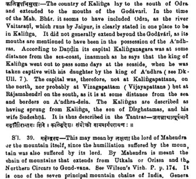
For Kalinga Janapada, the Mahendra mountain is so important that Kālidāsa just calls the king of Kalinga as Mahendranātha. The mountain was a personification of Kalinga. M.R. Kale discusses this geography in his translation of Raghuvamśa, concurring that it spread upto Godavari. 

Instead of seeing Mahendra as a Kulaparvata that is an entire mountain range, as detailed in the Purāṇas, the British General Cunningham (the famed looter and the originator of the Archeological Society of India) located it on one single peak : Mahendragiri in southern Odisha.
In fact, the native name for the entire northern eastern ghat region (Mahendra Parvata) is now lost to the very people of these lands. These sacred mountains extend till Godavari, where it parts them majestically at Pāpikoṇḍalu. People instead call them "eastern ghats".
There were native Indian indologists, like Anundoram Borooah who disputed with Cunningham, and argued that Kalinga must be seen as extending upto the Godāvarī.
The very name Rājamahēndri (Rajahmundry) was seen by him as referring to the Kalinga region.
The very name Rājamahēndri (Rajahmundry) was seen by him as referring to the Kalinga region.

In fact, the current wisdom on Rājamahēndri has become so twisted that people argue that this city was named after a late 11th century conqueror from the Eastern Chālukya kingdom, Rāja Rāja Narēndra. How did "Narēndra" become "Mahēndra"? Just so stories were invented like that.
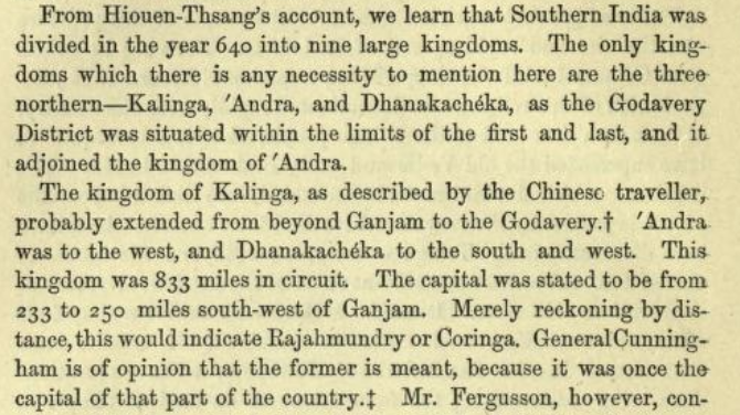
Native history of the people from Gōdāvari region, in the very early stages as recounted here by the British surveyor Henry Morris, ascribed the name Rajamahēndri to a king of Kalinga, known as Mahendra Deva. This is a natural epithet for a Kalingan king, as we see from Kālidāsa. 

In the travelogues of XuanJang, the kingdom of Ganjam was recognized as separate from Kalinga, called as Kongota. He calculated a distance of 400-500 kilometers (converted from Chinese "Li" unit of his period) from Ganjam to the capital of Kalinga, which fits with Rajahmundry. 

One peculiar aspect of Kalinga Janapada, when it was being mentioned in the Purāṇas, is that it is often referred to as "Sakala Kalingas" (Kalingas in all regions). All those Kalinga provinces are then decisively grouped within the southern region of India (not eastern).
The Ṛkshaparvata is a bit northwards in the current state of Oḍisha. It seems the region of Vaitariṇī river i (which originates in the Ṛksha range, and not in the Mahendra range) was sometimes occupied by Kalingans. That was also then grouped into the southern petal of India.
This gentleman was so confused about his own native geography, he was offering me second hand references about what Mahendragiri meant. What do the quoted sources in Raghuvamśa or Mahābhārata say? Nothing about Ganjam being the southern border of Kalinga!
https://twitter.com/Somnath1289/status/1486001991369248771?s=20&t=tglmzD_9ZgjsfQ9FdEZHtA
The Ādi Parva of Mahābhārata describes a beautiful pilgrimage/travel route of Arjuna along southern coast line. Arjuna crosses Kalinga and goes along the sea coast by looking at the Mahendra Parvata and then travels inward to a kingdom called Manipura, where he meets Chitrāngada.
Then he travels further southwards into the Sahya mountains and until the southern ocean, where he liberates five Apsara damsels from their curse (they were cursed to be crocodiles that torment five sacred rivers). Then he goes northwards along the western coast until Dwāraka.
None of this makes any sense if Arjuna was shifting westwards from Ganjam. His pilgrimage would be abruptly ended. This nonsensical interpretation came about simply because a British General Mr. Alexander Cunningham decided to name a single mountain peak as Mahendra Parvata.
The Kalinga people were definitely a highly Sanskritic civilization. They were speaking a language that was a southern Prākrit, with a high intelligibility to Sanskrit. It might have very well sounded like modern Odiya. It definitely would not have sounded like the modern Telugu.
We can understand this by studying languages in other countries that were colonized by Kalingans, like Śrī Lanka. It is definitely closer to Odiya than to Telugu. So we must have had a language shift in the northern Andhra region, after it was conquered by the eastern Chālukyas.
It also makes sense, as Rāja Rāja Narēndra (the first eastern Chālukya king on Godavari) commissioned the first literature in Telugu: the Āndhra Mahābhāratam, translated by Nannayabhaṭṭa. Nannaya's language sounds Sanskritized, because that dialect was native to the region.
Until and unless we realize our native sense of geography, we will not be able to make sense of our culture or history. Unfortunately, we are boxed into nonsensical categories by a *racist* British scholarship (racist: there is no other word to describe that Dravidian nonsense).
I highly recommend everyone to read the original Indic texts describing India's native geography. You can even read English translations from Sanskrit done by British scholars, but do read them with a bucket of salt and bear with the racist stench and undercurrent.(End of thread)
• • •
Missing some Tweet in this thread? You can try to
force a refresh


