This is the UK-Met model's solution at 120 hours. As the AccessG model is associated with the UK-Met model (which only runs for 144 hours) for this reason I am discounting it in this scenario. The ECMWF and GFS models are the two tropical phenomena specialist models.
Here we see the ECMWF models 120-240 hour prognostication.
And here's the GFS 120-240 hour prognostication.
The main difference at the starting point is that the GFS is expecting four lows two strong & two weak and this results in a sharply different outcome.
But the important point to note is that both the ECM and GFS solutions bring these low systems in a South Westerly direction into the Tasman Sea - thereby continuing the current stormy weather over NZ.
Here we see GFS (left) & ECMWF (right) PWAT position at 120 hours.
Here is how the ECMWF model scenario unfolds from 8-13th Feb - the far north and most of the North Island is effected with very significant rain here from 9-11 Feb.
The GFS solution is a lot worse. Significant weather impact begins on 9th Feb and then gets a lot worse from the 11th as a mass of very wet air pushes directly south over NZ.
The GFS model runs for another 6 days and shows the burst of northerly moisture pushing due south and impacting the South Island + an NW atmospheric river and what looks like a cyclone headed in from the NE.
At this range this modelling is a bit science fiction-y mind.
DISCLAIMER: Everything beyond five days is s somewhat speculative (and gets more so the further out the simulation), but it does illustrate how potentially hazardous the existing climate change impacts are on NZ. We would do well to heed these warnings and prepare.
Simulations of the area of tropical moisture that brought torrential rains to the South Island now show a storm system moving south into the Tasman Sea resulting in intense rainfall across Northern NZ through Feb 12th.
Forecasts for this system's exact impact remain highly uncertain but four major global forecasting models are in agreement that some form of extreme weather for NZ will be result.
These are the latest ensemble tropical storm "spaghetti" track graphics for storms north of NZ.
The event is expected to begin within 24 hours these are four different models showing the intense area of atmospheric moisture moving over Northern NZ this morning (Sunday) NZT.
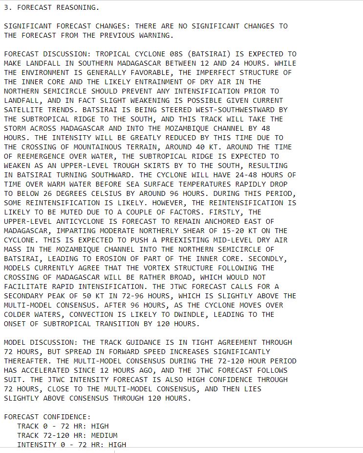
Cyclone Batsirai is weakening and accelerating on its final approach to Madagascar's East Coast. But while lower winds will be helpful - it's primary impact - widespread very heavy rain - is likely to be extreme.
The official forecast has not been updated, the eyewall landfall (diminished by the filling of the eye) is likely to take place a little later than forecast but wind and rain is already building over the island as is obvious in the satellite imagery.
As of 20 minutes ago the center of the cyclone had roughly 100kms to travel to the shoreline. It will a bring a significant tidal surge with it, especially on the southern side and likely cause significant coastal flooding over a large area of the coastline.
Both #Extrremeweather events caused by climate change, and 30+ years of failure to address known extreme damage to the biosphere caused by avoidable harms.
One nation responsible for the peril.
Another defenceless against it's catastrophic harms.
In one nation the harms will be felt mostly in travel delays.
In the other nation many will likely die, and 100s of thousands will have their lives scared and livelihoods threatened, and will likely be dependent on humanitarian aid for months if not years.
As a poster child for the impact of climate change on developing nations this cyclone, is a truly terrifying phenomena. In the next 24 hours it will make landfall at most likely Cat 4 or Cat 5 Hurricane Strength.
The animation above is live and covers the last three hours. This animation shows the last 24 hours.
Madagascar is an impoverished nation of nearly 30 million people the majority of whom live in the path of this Cyclone's wind and forecast extreme rain.
Whilst at Cat 4 strength a day ago what was already Intense Cyclone #Batsirai underwent a eyewall replacement and slowed down, it is now accelerating and strengthening.
Here's a broader view showing all of NZ and the cause of the rain converging atmospheric rivers coming together over the Tasman Sea and bringing a continuous stream of thunderstorms towards the Southern Alps.
The longer term picture depends on a complex storm picture north of NZ with a potential 2nd #ExtremeWeather event beginning around 9th Feb.
The current atmospheric river generated event is expected to conclude in around 5 days. Here's the latest GFS 5 day rain accumulation sim.
Beyond five days as detailed in the quoted thread, the global weather simulations diverge. Here is the GFS's current simulation rainfall expectations Feb 8-13. In this scenario the bad weather continues for a further 6 days.