မိမိဖုန်းကိုလုံခြုံအောင်ဘယ်လိုထားမလဲ……
ဖုန်းလုံခြုံရေးအတွက် အရေးကြီးတဲ့ အချက်များကို မျှဝေပေးချင်ပါတယ် 👇👇👇
1/7
#WhatsHappeningInMyanmar
#Myanmar #securityexplained
#MyanmarWitness
#ဒစ်ဂျစ်တယ်လုံခြုံရေး
#မိုဘိုင်းဖုန်းလုံခြုံရေး
ဖုန်းလုံခြုံရေးအတွက် အရေးကြီးတဲ့ အချက်များကို မျှဝေပေးချင်ပါတယ် 👇👇👇
1/7
#WhatsHappeningInMyanmar
#Myanmar #securityexplained
#MyanmarWitness
#ဒစ်ဂျစ်တယ်လုံခြုံရေး
#မိုဘိုင်းဖုန်းလုံခြုံရေး

2/7
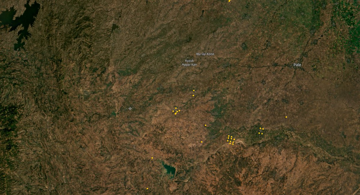
Important security tips for staying safe with a mobile phone in Myanmar.
#WhatsHappeningInMyanmar
#Myanmar #securityexplained
#MyanmarWitness
#ဒစ်ဂျစ်တယ်လုံခြုံရေး
#မိုဘိုင်းဖုန်းလုံခြုံရေး
Important security tips for staying safe with a mobile phone in Myanmar.
#WhatsHappeningInMyanmar
#Myanmar #securityexplained
#MyanmarWitness
#ဒစ်ဂျစ်တယ်လုံခြုံရေး
#မိုဘိုင်းဖုန်းလုံခြုံရေး

3/7
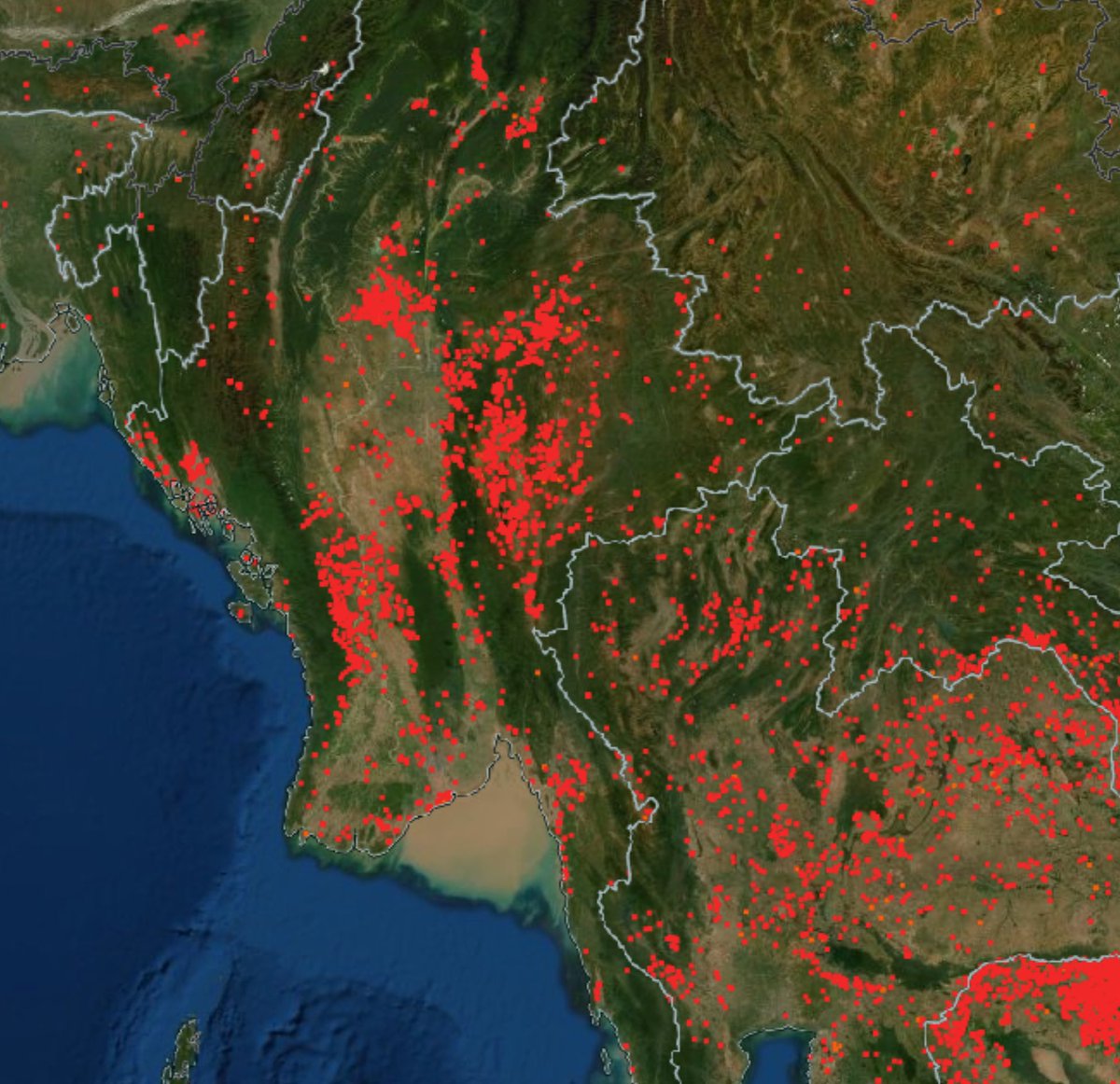
Important security tips for staying safe with a mobile phone in Myanmar.
#WhatsHappeningInMyanmar
#Myanmar #securityexplained
#MyanmarWitness
#ဒစ်ဂျစ်တယ်လုံခြုံရေး
#မိုဘိုင်းဖုန်းလုံခြုံရေး
Important security tips for staying safe with a mobile phone in Myanmar.
#WhatsHappeningInMyanmar
#Myanmar #securityexplained
#MyanmarWitness
#ဒစ်ဂျစ်တယ်လုံခြုံရေး
#မိုဘိုင်းဖုန်းလုံခြုံရေး

4/7
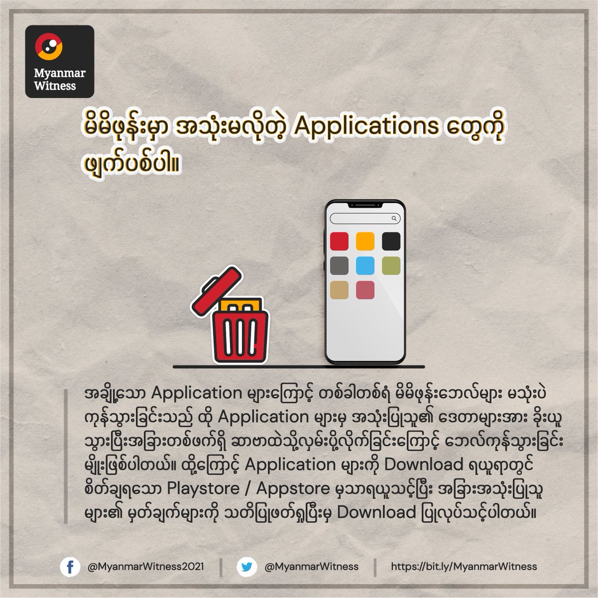
Important security tips for staying safe with a mobile phone in Myanmar.
#WhatsHappeningInMyanmar
#Myanmar #securityexplained
#MyanmarWitness
Important security tips for staying safe with a mobile phone in Myanmar.
#WhatsHappeningInMyanmar
#Myanmar #securityexplained
#MyanmarWitness

5/7
Important security tips for staying safe with a mobile phone in Myanmar.
#WhatsHappeningInMyanmar
#Myanmar #securityexplained
#MyanmarWitness
Important security tips for staying safe with a mobile phone in Myanmar.
#WhatsHappeningInMyanmar
#Myanmar #securityexplained
#MyanmarWitness
6/7
Important security tips for staying safe with a mobile phone in Myanmar.
#WhatsHappeningInMyanmar
#Myanmar #securityexplained
#MyanmarWitness
Important security tips for staying safe with a mobile phone in Myanmar.
#WhatsHappeningInMyanmar
#Myanmar #securityexplained
#MyanmarWitness

7/7
Important security tips for staying safe with a mobile phone in Myanmar.
#WhatsHappeningInMyanmar
#Myanmar #securityexplained
#MyanmarWitness
Email us: info@myanmarwitness.org
Important security tips for staying safe with a mobile phone in Myanmar.
#WhatsHappeningInMyanmar
#Myanmar #securityexplained
#MyanmarWitness
Email us: info@myanmarwitness.org

• • •
Missing some Tweet in this thread? You can try to
force a refresh