Alastair Thompson Profile picture
Feb 17 14 tweets 9 min read
#ExtremeWeather TS #Emnati Update:

After a night of explosive convection and organisation What was #96s #Invest96s or #TD5 is now #TSEmnati - and forecast to become - like #Batsirai an Intense Tropical Cyclone on Sunday packing Cat3 Hurricane intensity winds of 185kmh.
And the good news is that JTWC - [metoc.navy.mil/jtwc/jtwc.html… website seems to be back online. They were missed. Here is the latest official track forecast issued by JTWC Pearl Harbour this morning at 3:00Z (UTC). This storm can now be considered to be a major threat to Madagascar.
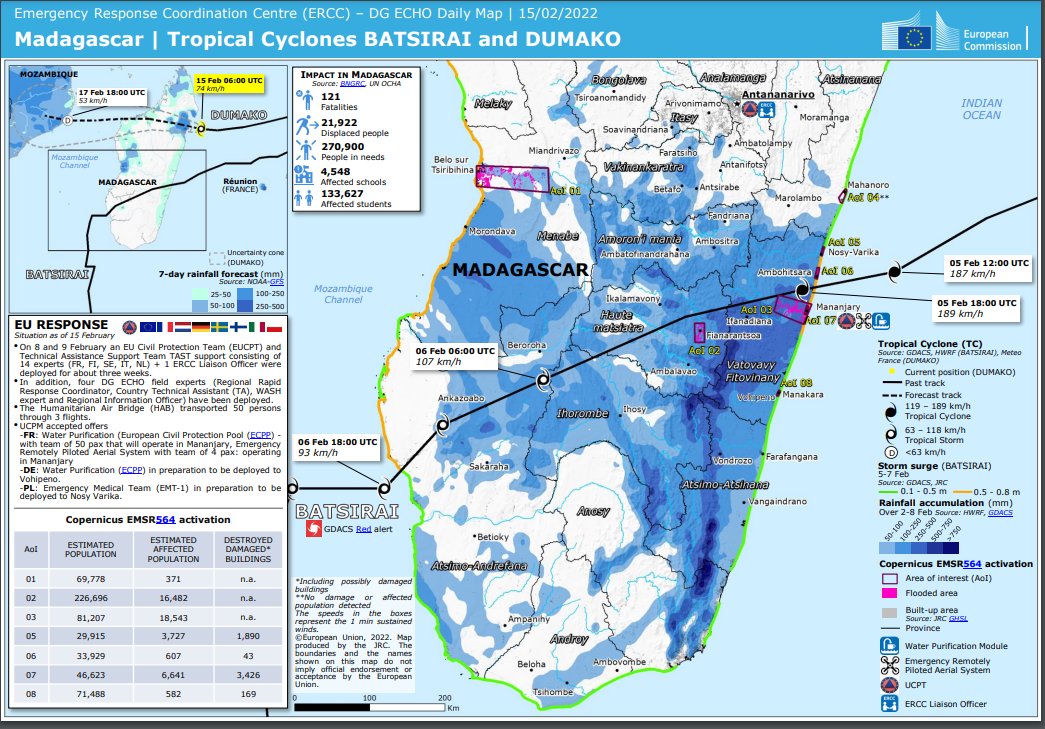
The forecast track is almost identical to that of #Batsirai, which has left over 120 Malagasy dead, destroyed and damaged 10s of thousands of homes and buildings. Flooded areas have not even drained yet.
Information on the current state of UN/NGO/Relief damage assessment following #Batsirai can be found here >> reliefweb.int/country/mdg
1. Number of damaged and destroyed classrooms in the districts as of Feb 14, 2022
2. Summary map issued Feb 15th 2022.
It hasn't really stopped raining since Batsirai, and is not expected to do so in the lead up to the forecast arrival of #Emnati generated more intense rains on Sunday/Monday most likely. Core cyclone strength rains are forecast to begin on Tuesday 22nd.
Like #Batsirai #Emnati is forecast to head West South West and cross Madagascar in approximately 48 hours. With hurricane force winds and storm surge arriving late Monday.

The track and heaviest rains are expected in exactly the same areas hit by #Batsirai.
Here's the 10m Wind forecast for the landfall period.
And from the ECMWF model a maximum wind gust forecast during the period of landfall.
On its final approach to Madagascar #Batsirai went through a eyewall replacement cycle - and weakened and slowed down a little before resuming strengthening.

But #Batsirai was a much more long duration cyclone. en.wikipedia.org/wiki/Cyclone_B…
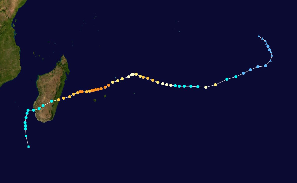
And so far #Emnati is not behaving as predicted. It is moving West North West rather then due west as expected in the track forecast. And as we can see here this is taking it into more shear which is slowing it down a little.
As you can see here its moving towards the area where #Dumako formed, and it is possible that this apparent variation in heading could result in a more northerly landfall in roughly 6 days time.
Here's another animation, zoomed out, without shear lines which shows the track variation more clearly.
This storm has proven very unpredictable so far and could continue to be unpredictable.

Cyclone forecast accuracy is considered good up to three days so it is unlikely that there will be a significant deviation from what is currently expected - beyond the landfall location site.
In the meantime the people of Madagascar have roughly five days to prepare for the arrival of a second Intense Cyclone #Emnati in the space of just over two weeks - the fourth landfalling Tropical Storm to strike the island in less than a month (#StormAna arrived Jan 24).

• • •

Missing some Tweet in this thread? You can try to force a refresh
 

Keep Current with Alastair Thompson

Alastair Thompson Profile picture

Stay in touch and get notified when new unrolls are available from this author!

Read all threads

This Thread may be Removed Anytime!

PDF

Twitter may remove this content at anytime! Save it as PDF for later use!

Try unrolling a thread yourself!

how to unroll video
  1. Follow @ThreadReaderApp to mention us!

  2. From a Twitter thread mention us with a keyword "unroll"
@threadreaderapp unroll

Practice here first or read more on our help page!

More from @althecat

Feb 17
The full UN meeting can be watched here >> media.un.org/en/asset/k12/k…

Beginning with an excellent briefing from @UN USG (Under Sec Gen) for Political and Peacebuilding Affairs.

The subject of the meeting is Minsk Agreements, which have failed to bring peace over the past 7 yrs. Image
The second briefing is from two representatives of the OSCE - the Organisation for Security and Cooperation in Europe - which is responsible for monitoring the Minsk Agreements.

Both briefers lament the absence of implementation of the Minsk Agreements. Image
Both briefers discuss the reasons for the failure to of the Minsk Agreements to be fully implemented. But they both also point towards there being less conflict over the past year.

And both thank the efforts by Germany and France to restart the Normandy 4 format talks.
Read 78 tweets
Feb 17
The problem is that @SecBlinken thinks his playing to his choir is clever. It’s not. It just looks daft.

Of course Russia will give this commitment to the UNSC. It has done so repeatedly already,

Most of world, especially the Govt. of Ukraine is getting tired of this circus.
This meeting to discuss a letter from Moscow r.e. Ukraine has been on the UNSC agenda since end of Jan. Russia is the current UNSC president.
This is one of the main reasons that all the talk from the US about “imminent invasion” has been so dumb. Russia signaled its willingness to take a diplomatic path in scheduling this meeting. Announcing it the Russian PR made clear Russia did not intend to invade.
Read 14 tweets
Feb 17
#ExtremeWeather #Warning #SouthEastAfrica

With formation of Tropical Storm #Emnati overnight and a high confidence forecast for the next five days. We need to also pay attention to potential impacts in Southern Africa, especially in the East.

Latest GFS 10 day rain sim below.
While Tropical Storm #Dumako has lost its JTWC designation the threat it poses to Mozambique is not over - we just won't have the same level of data to watch it as it crosses the Mozambique Channel.

The current spaghetti analysis from ECMWF suggests it won't strengthen.
However in the rainfall forecast we can see that heavy rain is forecast for Southern Mozambique and across the the continent over the next 10 days. This animation is from earlier today before #Dumako was taken off the monitoring list.
Read 12 tweets
Feb 17
Hi @MarksSimon, @Bloomberg, we have known this for literally seven months but you personally and the publications you have worked for @nytimes and @bloomberg consistently ignored these facts. Even @ap started reporting on the atrocities in Sept.

You now need to explain why?
Why were reporters in Kenya like yourself and @declanwalsh, and your editors in NY, DC and London so unwilling to dig deeper and ask the question why is it that there is a 2nd completely different narrative to this conflict?
Why did so many Western publications - because nearly every notable publication and Agency in the US UK and EU did this - suspend your critical thinking and take a course of action which almost certainly prolonged this war and the killing and the horror?
Read 7 tweets
Feb 16
Yesterday afternoon there was a Plenary session in the European Parliament on the eve of @AUEUSummit, scheduled for tomorrow and Friday. This tweet contains some edited highlights from High Representative @JosepBorrellF (who leads @eu_eeas).

But this misses a lot.

Thread....
The full video of Borrell's opening remarks is here >> multimedia.europarl.europa.eu/video/eu-afric…

11 minutes, in English. The remarks kick off a debate that included 42 speakers and concluded with some closing remarks from @JosepBorrellF.
The full video of the high representative's Plenary session begins at 15.13pm and can be watched here. The interventions of the 42 MEPs (Members of the European Parliament) from 15:22 are all short, limited to less than 2 minutes by procedure. multimedia.europarl.europa.eu/video/eu-afric…
Read 27 tweets
Feb 16
#ExtremeWeather Update Thread: Madagascar #Invest96S

The JTWC is now saying there is a "High" probability of #Invest96S will become a TC within the next 24 hours.

The JTWC @USNavy @USNRL website [Here: metoc.navy.mil/jtwc/jtwc.html] remains inaccessible.
@USNavy @USNRL While we do not have a JTWC track forecast yet, we do have a new forecast. the relevant part for #96s is in the 2nd image here and contains reasoning as to why:

"THE POTENTIAL FOR THE DEVELOPMENT OF A SIGNIFICANT TROPICAL CYCLONE WITHIN THE NEXT 24 HOURS IS UPGRADED TO HIGH."
Here's a current 24h animation of the storm, at the end you see the center of circulation is fully exposed. The storm is moving fairly fast and is being blown westwards by winds which are creating a lot of shear - which prevents development.
Read 19 tweets

Did Thread Reader help you today?

Support us! We are indie developers!


This site is made by just two indie developers on a laptop doing marketing, support and development! Read more about the story.

Become a Premium Member ($3/month or $30/year) and get exclusive features!

Become Premium

Don't want to be a Premium member but still want to support us?

Make a small donation by buying us coffee ($5) or help with server cost ($10)

Donate via Paypal

Or Donate anonymously using crypto!

Ethereum

0xfe58350B80634f60Fa6Dc149a72b4DFbc17D341E copy

Bitcoin

3ATGMxNzCUFzxpMCHL5sWSt4DVtS8UqXpi copy

Thank you for your support!

:(