
A long range image based weather forecast thread for #Ethiopia, #NorthAfrica #MiddleEast and #India...
Occasioned by my return from Ethiopia to my home in France. These first two images show #Ethiopia on June 2nd and June 7th (today). The big rains are beginning.
Occasioned by my return from Ethiopia to my home in France. These first two images show #Ethiopia on June 2nd and June 7th (today). The big rains are beginning.


These three big pictures show satellite observed cloud activity yesterday over the tropical belt in the populated hemisphere from the Western Pacific across the Indian and Atlantic Oceans to the Eastern Pacific.


The description part of this thread begins over the Indian Ocean which as you can see here - in a 16 day precipitable water forecast - is filling up with water coming in from the east.
On the basis of this GFS model forecast it looks as if the Indian Monsoon is about to begin.
On the basis of this GFS model forecast it looks as if the Indian Monsoon is about to begin.
This animation shows the accumulating rainfall forecast over this 16 day period.
This animation provides more details about the atmospheric water movement in the Indian Ocean over this period.
The dominant water flow pattern indicated here is south west (up the East coast of Africa) towards the north west. And is forecast to strengthen rapidly.
The dominant water flow pattern indicated here is south west (up the East coast of Africa) towards the north west. And is forecast to strengthen rapidly.
There is a reason I am focussing on this, as it is this burst of monsoon activity which will also bring the big rains to Ethiopia, which will provide the rain for the Grand Ethiopian Rennaissance Dam (GERD)'s next filling, and deliver the rain needed for this year's harvest.
This image shows the GERD dam on June 2nd (Sudan's Rosieres dam is top left). You can see that the lake is already turning brown as the Abay flood waters arrive. This is the last clear satellite image of the dam. It has been obscured by cloud ever since.

This satellite animation shows the last 24hours over the Horn of Africa.
This wider view shows the complexity of the atmospheric water flows over East Africa and the West Indian Ocean.
This GFS model 16 day forecast of 250hpa Jetstream winds (8kms to 15kms altitude) shows the beginning of formation of a climatic feature which will help bring the big rains. The winds - shown moving westwards over southern India here, will pick up water from the Indian monsoon.
This is the latest GFS accumlating rain forecast from today through to the 17th of June.
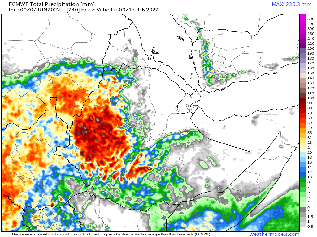
There's a fair bit of variation between the three model forecasts in the details we have for Ethiopian rain over the coming 10 days (1. ECMWF [euro], 2.GFS [US] and 3&4. KMA 10&12 days [Korea]) but the overall picture is consistent the rains are starting.


We now zoom out to the North African Picture more broadly. This animation shows the Sahara over the past 24 hours, including revealing an atmospheric river originating in West Africa carrying water to the Levant.
Here we see the overall atmospheric water picture which shows - as climate models have been predicting - increasing quantitites of atmospheric water over the Sahel.
The atmospheric climate anomaly is more obvious in this view - showing precipitable water anomalies vs the 1981-2010 data set. But deterministic (physics) model predictions of rainfall from this vary considerably.
Here are four model forecasts
1.ECMWF,
2. EPS (Euro Ensemble),
3. GFS and
4. KMA models.
1.ECMWF,
2. EPS (Euro Ensemble),
3. GFS and
4. KMA models.


The Canadian CMC model has been consistently the most bullish model when it comes to #DesertRain.

We also have two longer range model rainfall forecasts.
1. GFS 16-days (384 hours)
2. KMA 12-Days (288 hours)
1. GFS 16-days (384 hours)
2. KMA 12-Days (288 hours)


To complete the Africa portion of this long rainge weather forecast bulletin here is the Africa wide IWVT (Integrated Water Vapour Transport) model forecast from the GFS 3hr model.
This shows the clearest view of the NW Indian Ocean atmospheric water flows.
This shows the clearest view of the NW Indian Ocean atmospheric water flows.
The final set of forecasts are for the Middle East. And to introduce them we have another big picture, showing the Horn of Africa, Egypt, the Near & Middle East and the Indian subcontinent, an area representing a very significant portion of human history and population.

Here's a PWAT forecast for this area, this time from the Australian Access-G model.
For now at least it appears that the unusual June 2021 rains in Saudi Arabia (see quoted tweet) are not in the forecasts.
https://twitter.com/althecat/status/1405540200126636048?s=20&t=3Z6J0fmLK7i4HIVNivKZag


Here we have three longer range forecasts for the middle East. The EPS model shows a fair bit of rain over the Jinzan Mountains from Yemen up the Eastern Red Sea Coast. Time will tell.
1. EPS Ensemble (15 days)
2. GEFS Ensemble (16 days)
3. KMA (12 days)
1. EPS Ensemble (15 days)
2. GEFS Ensemble (16 days)
3. KMA (12 days)


Which is not to say there is not a lot of extreme weather out there......
Check out @Arab_Storms for the latest events, of which there appear to be many.
/ENDS
@Threadreaderapp unroll
Check out @Arab_Storms for the latest events, of which there appear to be many.
/ENDS
@Threadreaderapp unroll
• • •
Missing some Tweet in this thread? You can try to
force a refresh


