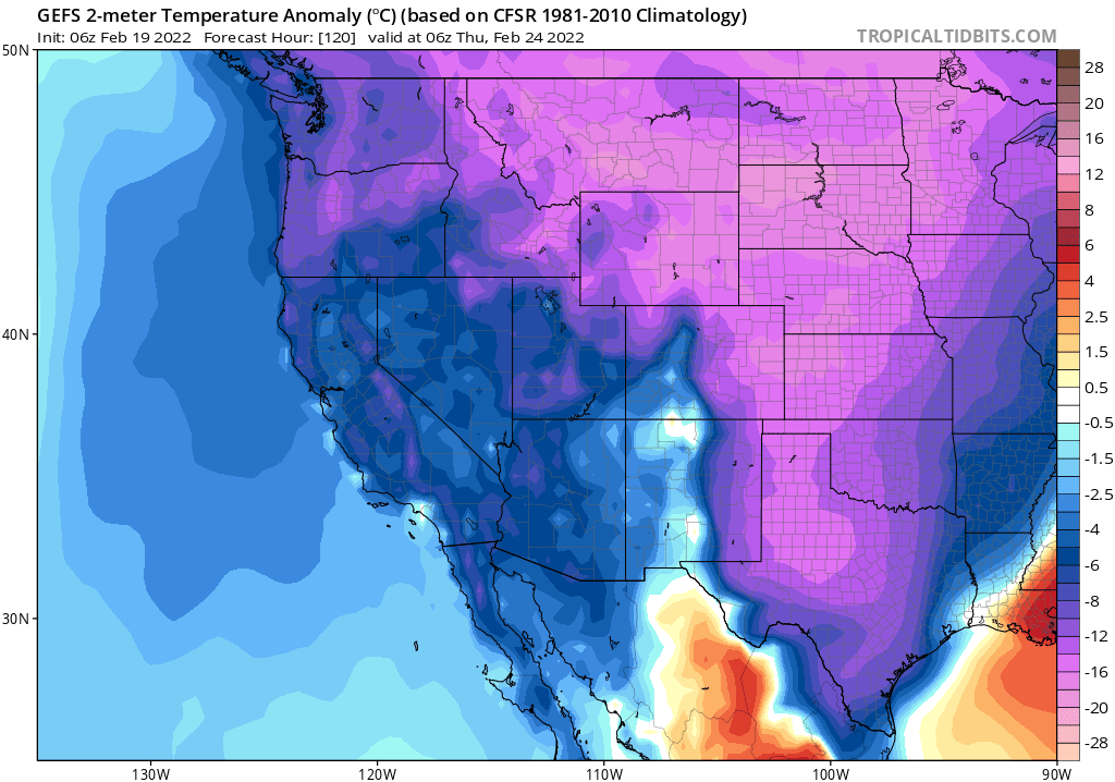
Much of CA & NV has had a fairly mild start to summer--especially in the northern third of state, which even received some late-season precip and some locally below average temperatures over the past month or so. Well, that's all about to change across the interior... #CAwx
A huge ridge of high pressure will expand westward from its current position near center of continent (where it has been bringing record heat to Texas). This will bring an extremely broad region of hotter than usual temperatures to the entire western 2/3 of the country. #CAwx
While a persistent Four Corners ridge, plus hot temps, are typical for mid summer--this ridge will be significantly broader & stronger than usual even for mid-late July. By late July, much hotter than usual temperatures could extend from Pacific Coast to Great Plains! #CAwx
At this time, it is not entirely clear just how hot it will get. Prolonged extreme heat, possibly record breaking, will be possible in some portion of western 2/3 of U.S. during this period. But at the moment, that looks more likely over Great Plains vs West Coast.
In California, the first wave of heat will affect the interior this weekend before relenting somewhat by mid-week. But the secondary heat peak beginning around 10 days from now and continuing for at least 7+ days may be much more consequential and prolonged. #CAwx#CAfire
This heatwave will be remarkable more for its great spatial extent and duration as opposed to its maximum intensity (though again, that could perhaps change, as some ensemble members are suggesting the potential for even hotter conditions). #CAwx#CAfire
The combination of widespread hotter-than-usual conditions and a depressed monsoon over the next ~2 weeks will likely accelerate fire season across drought-stricken interior western forests, including the Sierra Nevada. #CAfire
• • •
Missing some Tweet in this thread? You can try to
force a refresh
This was, by any quantitative measure, an extraordinary (and meteorologically extreme) lightning event across the southern half of California. But the societal impacts will be nowhere as severe as the dry lightning event in August 2020? Why? A brief thread: #CAwx#CAfire
First, & most importantly, the June 2022 thunderstorms were generally significantly wetter than the Aug 2020. Yesterday, most of these cells brought at least brief rains (and sometimes downpours). There were certainly dry strikes outside of rain cores, but most strikes were wet.
The June 2020, by contrast, were truly dry thunderstorms--many places only saw a trace of rainfall or nothing at all. Even a modest amount of rain co-occurring with lightning can greatly reduce (though not eliminate) the likelihood of a lightning-caused wildfire ignition.
Although I almost always keep my Tweets focused on weather, climate change, and related Earth system events, this thread is going to be a little more personal. May is #EhlersDanlosAwarenessMonth...and I have Ehlers Danlos Syndrome (hypermobility type). #hEDS (1/41)
Before continuing, I want to emphasize that I'm #NotThatKindofDoctor--I'm a physical scientist & science communicator, not a biomedical scientist nor a medical doctor. All the information and reflections in this thread are therefore either personal reflections... (2/41)
...or come from the perspective of a "highly informed patient." I do, however, strive to get the facts right, and offer links to various true experts in the clinical and research fields below. (3/41)
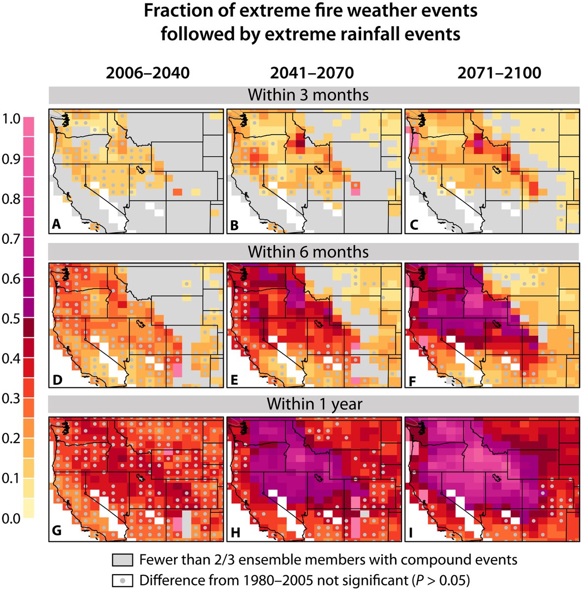
We use climate model large ensembles (CESM-LENS and CanESM2) to quantify projected changes in 99.9th percentile rainfall days that follow 99.9th pctile fire weather days. We find strikingly large & widespread increases in every Western state.(2/n) science.org/doi/10.1126/sc…
This increase in fire-following extreme rainfall events is driven by widespread increases in both extreme fire weather conditions and high-end precip events--so it's not just one side of the equation driving this large increase in compound events.
(3/n) science.org/doi/10.1126/sc…
Now that activity on the #NCARFire in Boulder, CO has calmed down significantly, a majority of the evacuation orders have been lifted, and the risk of property loss moving forward appears low, I wanted to share a few related thoughts. (All photos from yesterday, 3/26/22.) #COwx
1) NCAR Fire is an example of a relatively small fire posing disproportionately high risk to homes in wildland-urban interface. Should an ignition have occurred exactly the same place during one of Boulder's infamous downslope windstorms, it could have been a catastrophic event.
2) Emergency comms during this event were...not good. There was little info during first 1.5 hrs, which would have been critical had conditions been worse. Then, suddenly, a startlingly wide evacuation was ordered for ~15-20k people well *upwind* of fire,causing traffic gridlock.
Some mixed news on CA weather front over next couple of weeks. First, by Monday, another "inside slider" system will bring another burst of cooler & winder conditions statewide. Once again, some Sierra snow showers are possible, but most places stay dry. #CAwx#CAwater
Midweek, however, an even colder airmass and associated low pressure center will slide down the coast slightly farther to the west. This system, although still quite dry, stands a better chance of bringing convective activity (scattered showers/isolated thunder) statewide. #CAWx
The biggest impact from this mid-week system, outside of some additional modest Sierra snow accumulations and a few pockets of accumulating small hail showers at lower elevations (like last week in SoCal), will be a dramatic shift toward much colder temperatures. #CAwx
They find a strong trend toward increased nighttime fire activity across most regions globally, driven primarily by increases in overnight vapor pressure deficit (VPD). In western U.S., number of flammable nights have increased by 45% in past 4 decades! nature.com/articles/s4158…
These quantitative findings strongly corroborate widespread anecdotes from wildland firefighters, who have reported remarkable increases in nighttime burning activity that seriously challenge historical fire management strategies--which assume fires usually "lie down" at night.