After 6 months of war, time to look at the "current" front at which the war hinges, the southern front.
Long thread incoming.
Feel free to ask questions!
#ukraine #UkraineRussianWar
Lets start with the intial map:
Long thread incoming.
Feel free to ask questions!
#ukraine #UkraineRussianWar
Lets start with the intial map:

As we have learned, a key factor are supply lines.
To underline that, I have combined above map with the openrailwaymap of the area.
Orange and brown are the significant railway connections of the area.
This combined map will be the basis of further analysis.
#ukraine
To underline that, I have combined above map with the openrailwaymap of the area.
Orange and brown are the significant railway connections of the area.
This combined map will be the basis of further analysis.
#ukraine

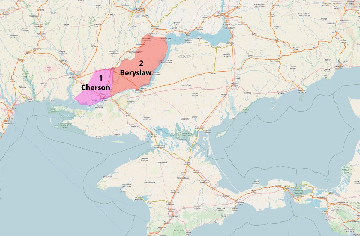
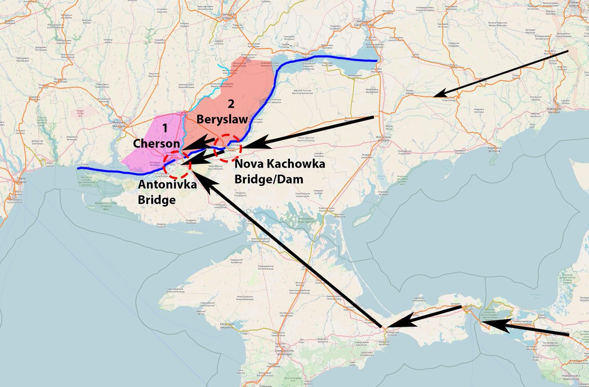
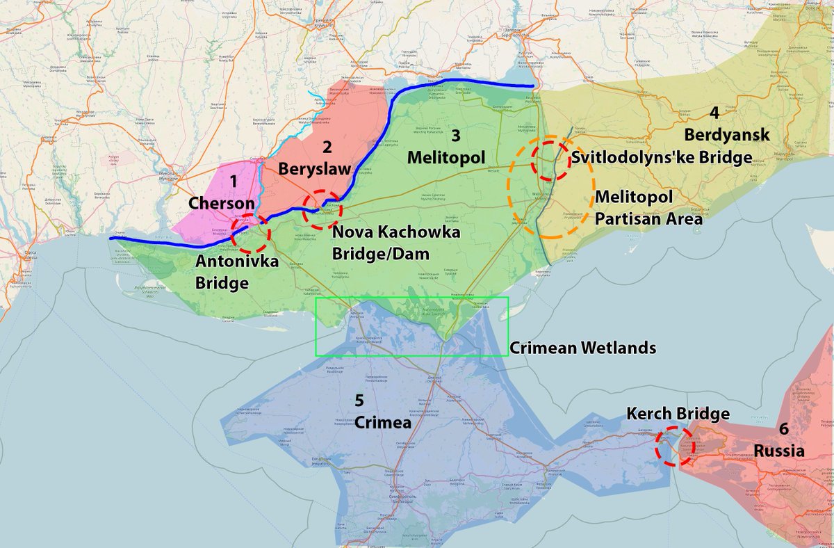
The first initial area to look at is the area of the biggest city, Cherson.
We are going to split the map into areas of interest, Cherson being 1.
We use the approximate russian area of control to outline the sectors, as we analyze the russian situation.
#ukraine
We are going to split the map into areas of interest, Cherson being 1.
We use the approximate russian area of control to outline the sectors, as we analyze the russian situation.
#ukraine

Slicing of the areas into logical sectors allows us to identify possible weaknesses in the russian position, and develop a stratagem to defeat them.
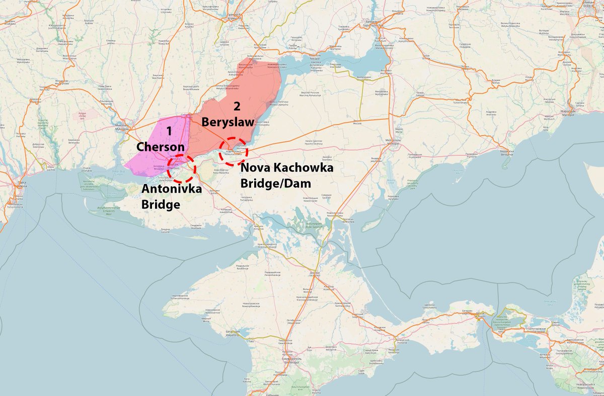
I call the second area Beryslaw, after the city near the Nova Kachowka Dam.
#ukraine
I call the second area Beryslaw, after the city near the Nova Kachowka Dam.
#ukraine
The two areas are strongly defined by two chokepoints, the Bridge and Dam over the Dnepr river.
Significant supply throughput is only possible through these two chokepoints, this is why #himars have focused attacks on them for the last two weeks.
#ukraine
Significant supply throughput is only possible through these two chokepoints, this is why #himars have focused attacks on them for the last two weeks.
#ukraine
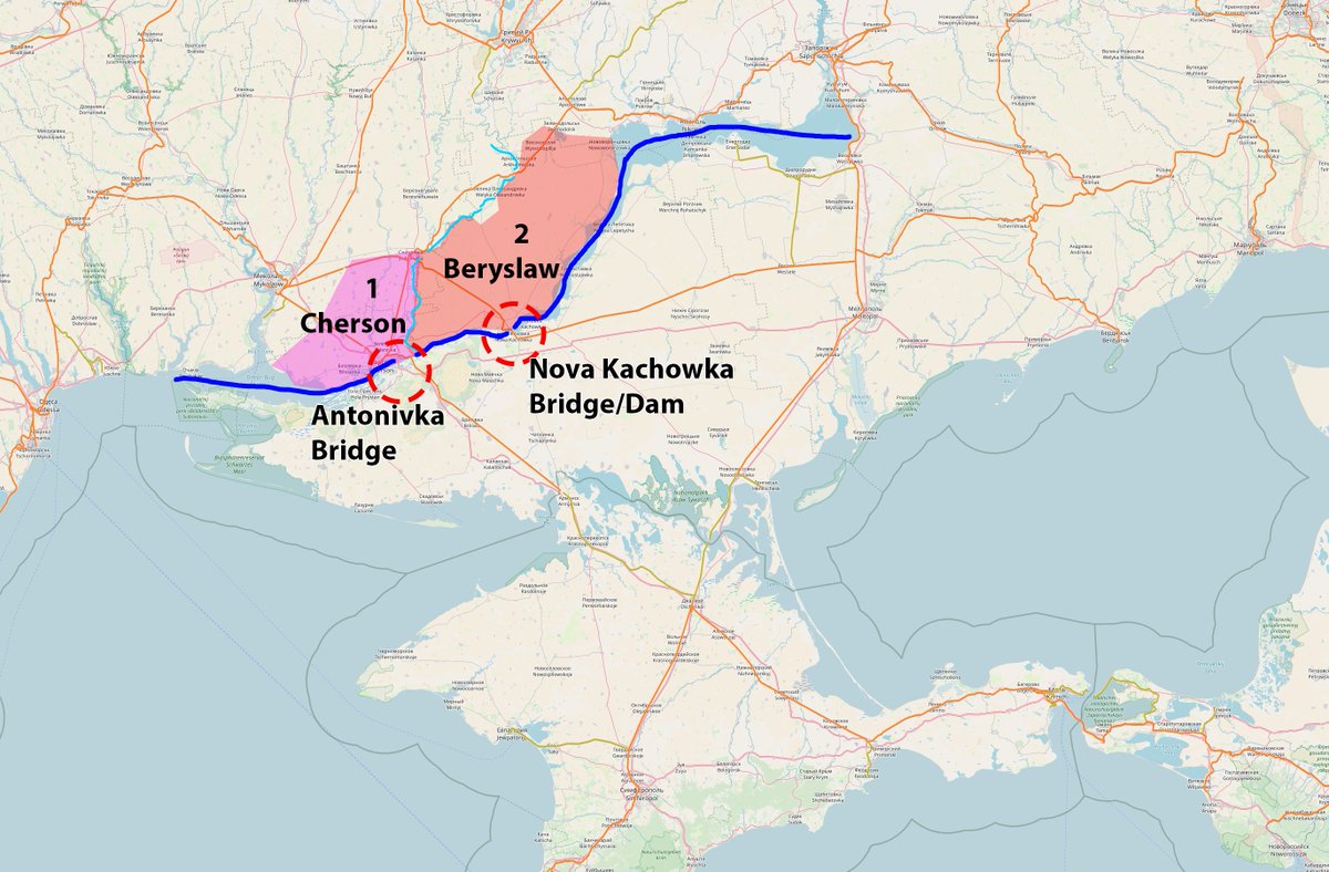
In addition to the Dnepr (big blue line), the Inhulets river (thin blue line) seperates Sector 1 and 2, with only few bridges between them, and creating a natural obstacle.
#ukraine
#ukraine
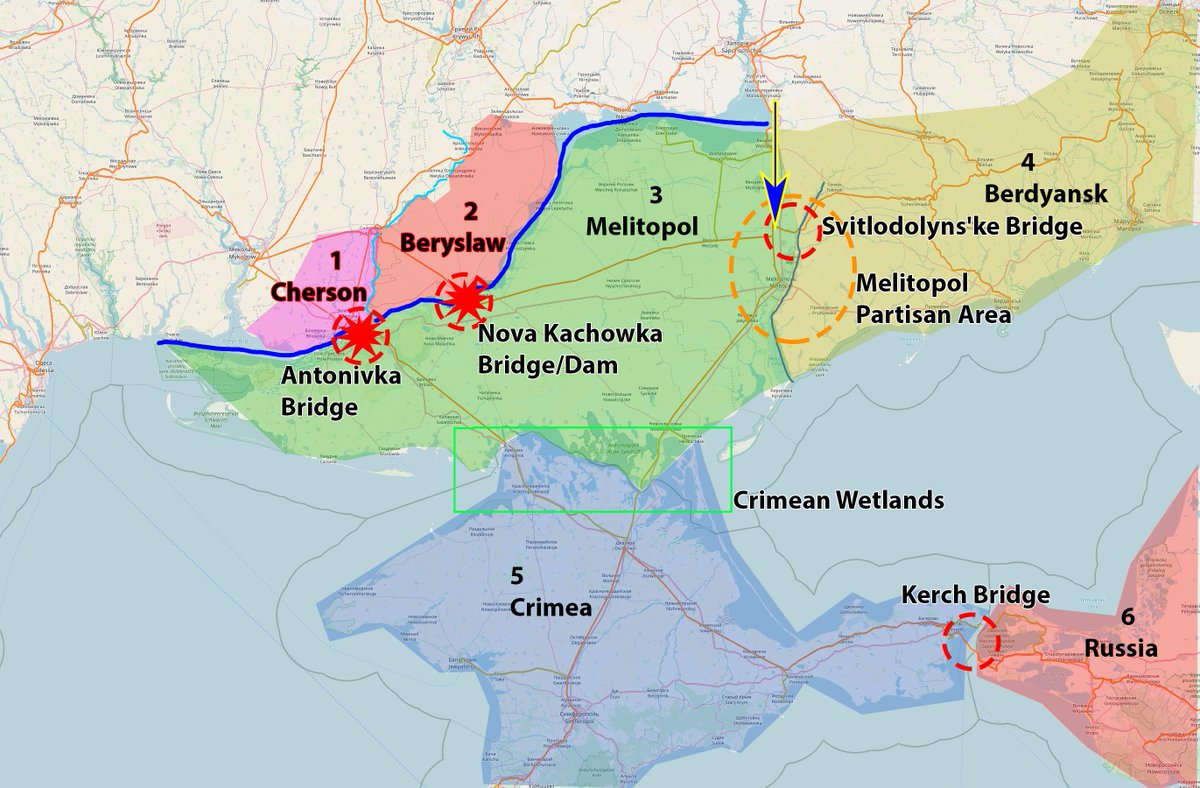
To understand the russian position, supply lines need to be understood well. Russia can supply both sectors only through two supply lines.
a) from Donezk area via Melitopol
b) through Kerch Bridge via Crimea
#ukraine
a) from Donezk area via Melitopol
b) through Kerch Bridge via Crimea
#ukraine
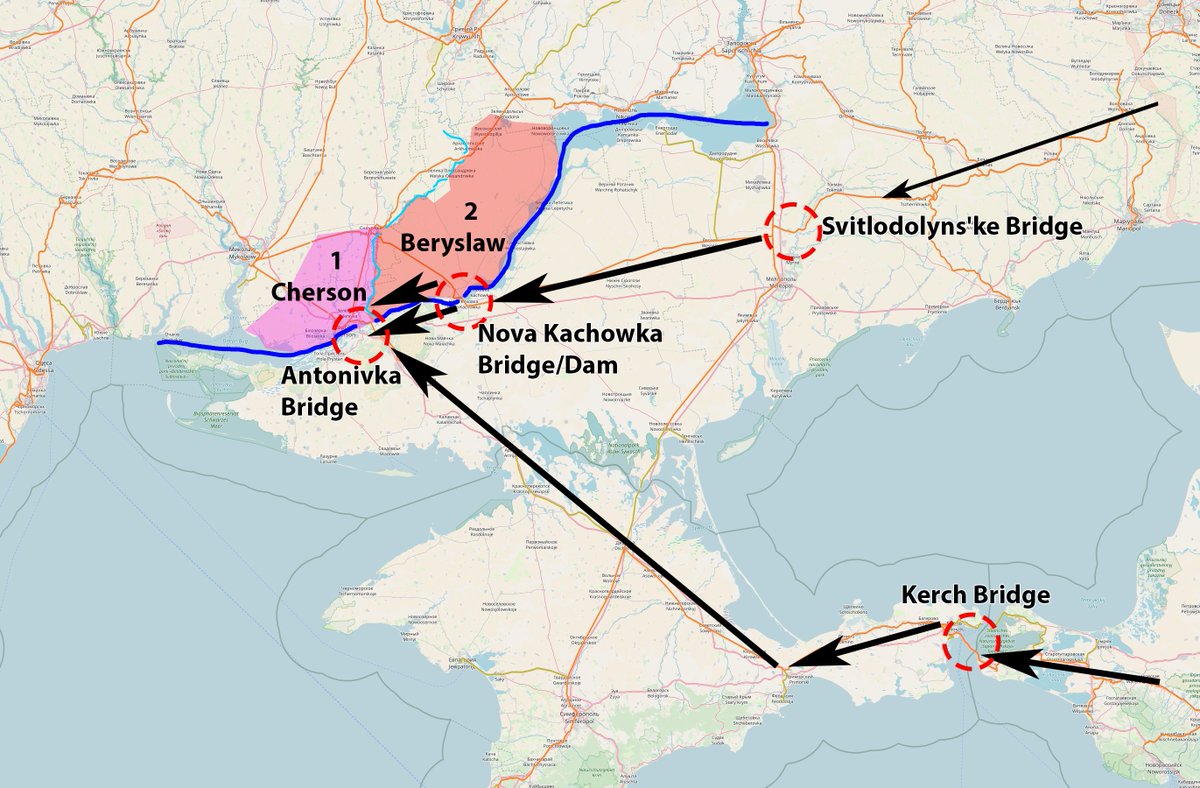
Tracing back those supply lines, we immediately spot the next "chokepoints".
a) the bridge near Svitlodlynske (and associated rail node Nowobohdaniwka)
b) the "famous" Kerch bridge
HMM! This creates the next logical sectors!
#ukraine
a) the bridge near Svitlodlynske (and associated rail node Nowobohdaniwka)
b) the "famous" Kerch bridge
HMM! This creates the next logical sectors!
#ukraine
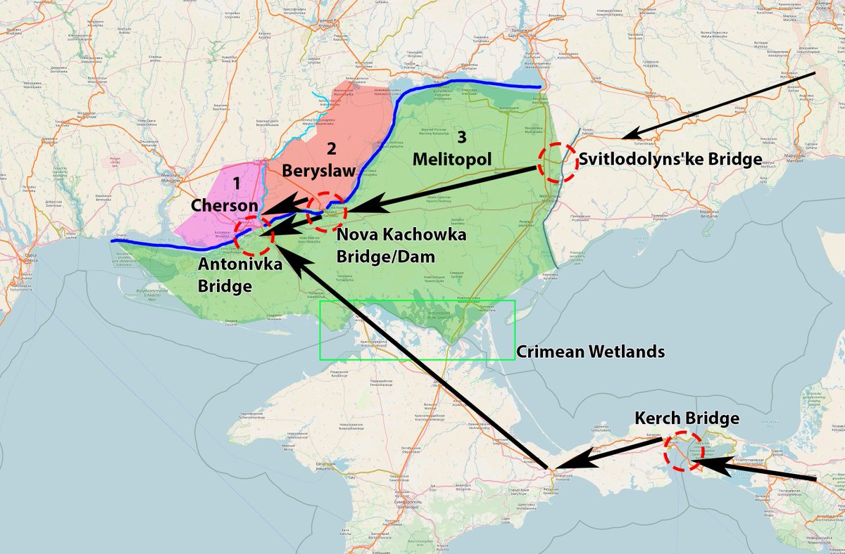
Sector 3 is called Melitopol, as the River Molochna and the North-Crimean Wetlands seperate it from the other areas.
This allows us to "fill in the blanks with 3 more sectors, to then analyze the best way to "un-orc" the sothern front.
#ukraine
This allows us to "fill in the blanks with 3 more sectors, to then analyze the best way to "un-orc" the sothern front.
#ukraine
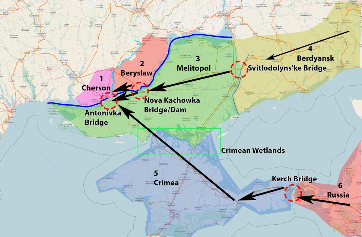
The 3 final sectors are:
4. Berdyansk
5. Crimea
6. Russia.
Looking at this map, we can actually see how long range precision rocket artillery plays a pivotal role for #ukraine.
4. Berdyansk
5. Crimea
6. Russia.
Looking at this map, we can actually see how long range precision rocket artillery plays a pivotal role for #ukraine.
To complete the picture, one must also account for the brave partisan movement around melitopol.
These are constantly interrupting railway connections and other transport infrastructure.
So what is the goal, for all sides?
#Ukraine
These are constantly interrupting railway connections and other transport infrastructure.
So what is the goal, for all sides?
#Ukraine
The #1 and super obvious, ongoing target for #ukraine is cutting off Sector 1 and 2, as they are russian Bridgeheads over the Dnepr.
Sadly, this operation is much slower than expected, but very critical for UA to succeed before autumn.
Sadly, this operation is much slower than expected, but very critical for UA to succeed before autumn.

Russia has been reinforcing the south ALOT. I believe this is due to the strategical opening for #ukraine to cut off most of the russian forces with a forceful, but short, advance towards Melitopol.
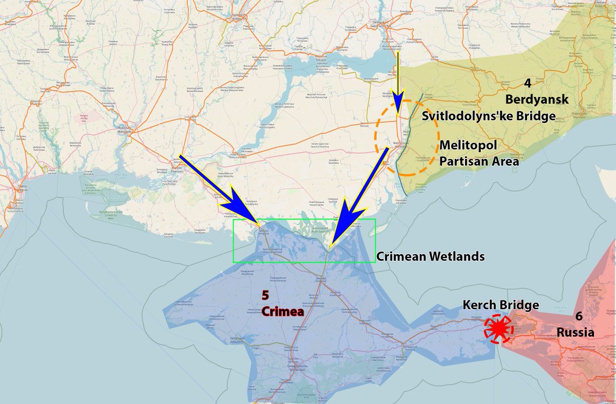
Such an 80km advance, if held, could see the russian front collapse.
Such an 80km advance, if held, could see the russian front collapse.
This would also need the destruction of the Kerch Bridge to succeed.
Then, Sector 1,2,3,5 would be cut off from any meaningful supplies, or even a retreat.
History taught us that Armies break without supplies or a way to retreat.
#ukraine
Then, Sector 1,2,3,5 would be cut off from any meaningful supplies, or even a retreat.
History taught us that Armies break without supplies or a way to retreat.
#ukraine
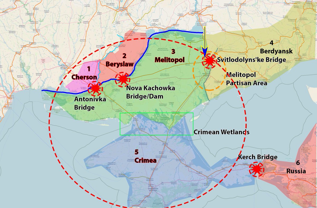
The russian front hinges on a bridge and a position 85km from the frontline. #ukraine is in a good position, if they can show that they can execture maneuver warfare.
This is yet to be seen, but if done right, could win the war.
Why? How?
This is yet to be seen, but if done right, could win the war.
Why? How?
If the russian army in Sector 1-3 collapse, all that would stop #ukraine from recapturing Crimea would be the two chokepoints at the Crimean Wetlands
This is where I am afraid that Putin may use "Tactical nuclear weapons".
After years of propaganda, if Crimea falls, Putin dies.
This is where I am afraid that Putin may use "Tactical nuclear weapons".
After years of propaganda, if Crimea falls, Putin dies.
This is because Crimea, by Russian Propaganda-ism "logic", is Russia.
Putins dictatorship will collapse with the southern front, this is my prediction, this is why I consider this the "big one" for the war.
The west must ensure for #ukraine to win this battle.
#freedom
Putins dictatorship will collapse with the southern front, this is my prediction, this is why I consider this the "big one" for the war.
The west must ensure for #ukraine to win this battle.
#freedom
If you liked this, maybe take a look at my March 28th prediction of the "Kupriansk-Izyum-Lyman Operation", which is still ongoing, and failing.
Take a look if you are interested, I was not too far off.
Take a look if you are interested, I was not too far off.
https://twitter.com/chrisschmitz/status/1508177160384794631
@threadreaderapp unroll
• • •
Missing some Tweet in this thread? You can try to
force a refresh