Josh Morgerman Profile picture
Sep 23 5 tweets 3 min read
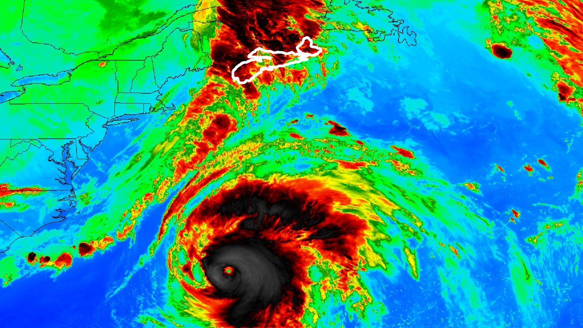
In all seriousness now... Much of #NovaScotia is now under a #Hurricane WARNING, including capital city, Halifax. #FIONA will race this way, with center reaching the coast Saturday morning. My plan is commonsense: 1/5
Heading E at crack of dawn to Cape Breton Island where I'll set up HQ in Sydney (on E end). Since FIONA will be embedded in strong steering flow, & since it'll be a large target (no tight, tropical core like in Dominican Republic), I'm expecting straightforward chase. 2/5
Being diehard nerd, I'm most excited about the air-pressure data. Here are lowest pressures I've recorded in decades of chasing. Where's #FIONA gonna score on this list? Curious. P.S. Global models suck with intensity & I think they're overcooking FIONA's at landfall up here. 3/5
Since folks asked: this event will not be my No. 63, because each hurricane counts once. I already conquered FIONA down in jungles of Dominican Republic. No extra notch on the bedpost for sloppy extratropical seconds. (If I did count double penetrations, this would be my 65.) 4/5
Meantime: It’s gotten windy since I landed in YHZ. I can hear it howling outside. Not surprised: these wind fields can get huge as cyclones move N. Folks in E Nova Scotia should complete preparations BEFORE DARK Friday, as FIONA will start hitting before dawn Saturday. 5/5

• • •

Missing some Tweet in this thread? You can try to force a refresh
 

Keep Current with Josh Morgerman

Josh Morgerman Profile picture

Stay in touch and get notified when new unrolls are available from this author!

Read all threads

This Thread may be Removed Anytime!

PDF

Twitter may remove this content at anytime! Save it as PDF for later use!

Try unrolling a thread yourself!

how to unroll video
  1. Follow @ThreadReaderApp to mention us!

  2. From a Twitter thread mention us with a keyword "unroll"
@threadreaderapp unroll

Practice here first or read more on our help page!

More from @iCyclone

Mar 1, 2020
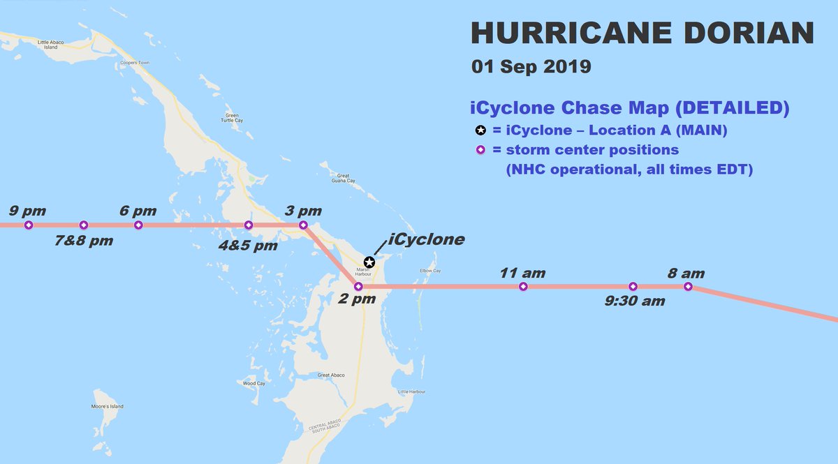
6 months ago this morning, Category-5 #Hurricane #DORIAN, with winds of 160 knots (185 mph), made perfect, direct hit on Marsh Harbour in #Bahamas. I was there. This morning I’ll tweet like I would’ve in real time, if I’d still had connection to outside world. Check back here.
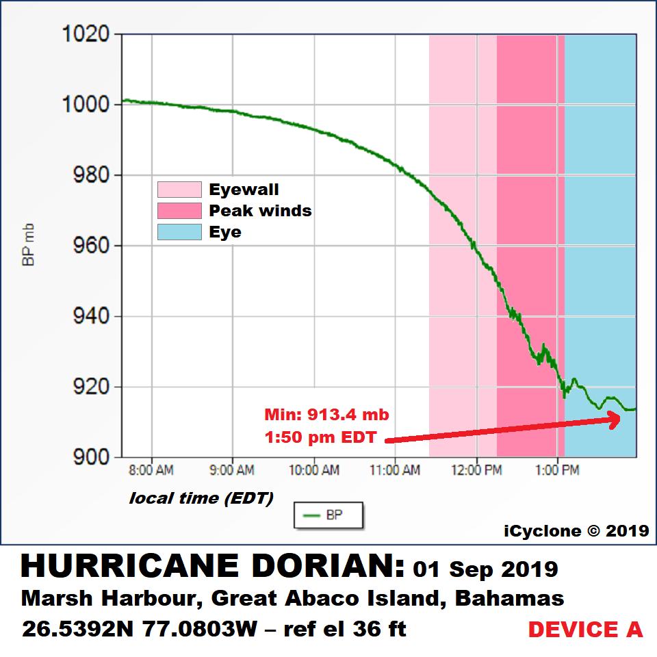
11:30 am (01 Sep): In a school on a hill—hunkered down in solid-concrete classroom with 11 others, including toddlers. Radar says hurricane’s inner core is just about here. Winds getting nasty—trees coming down, stuff flying. Feel like I'm about to get on rollercoaster. 973.4 mb.
12:12 pm (01 Sep): Getting deep in cyclone's inner core. Wind coming in big, sweeping pulses—& getting worse. Roaring. Gusts hammering walls with force of dynamite. Watching it all through cracks in shutters on downwind side of room. 952.4 mb.
Read 12 tweets
Dec 28, 2019
Time for countdown: my Top 10 chases of 2010s! I've got lots of war stories, & it hurt to limit myself to 10. Criteria varied, ranging from intensity to fear factor to footage coolness to quality of my data. Rankings are subjective, & y'all may hate my decisions. Ready? Let's go!
No. 10: #Typhoon #KAMMURI
Dec 2019 – Legazpi City, PHILIPPINES – Cat 4
Intense Christmastime cyclone slammed Filipino port city. Despite nighttime darkness, I caught some of my best footage of combo wind/water assault on waterfront. Bonus: weirdly violent wave action in calm eye.
My timestamped footage from #KAMMURI. The real pounding (in the front eyewall) happens from ~11:16 pm to ~12 midnight. Wind & water become one ferocious flow of energy ripping in off the gulf:
Read 41 tweets
Sep 8, 2019
1/5—Full report coming! In meantime, remarks Re: my #Hurricane #DORIAN data:

Buildup to peak winds was gradual—even once I was in eyewall—likely because of cyclone’s slow forward motion.

Eye had bright, misty quality—I didn’t get stadium effect. Lull lasted long: ~1:05-2:30pm.
2/5—I collected data w/ 2 devices. They matched well: 913.4mb (1:50pm) & 913.7mb (1:53pm) in eye. I sadly ended data collection in eye, as I needed to relocate to safety. I believe I caught min pressure, as it was starting to edge upwards when I relocated—but can’t be sure. Grrr.
3/5—It’s clear my location was stricken by high-energy mesovortices. Couldn't see them in 100% whiteout, but that’s only explanation for crazy pressure fluctuations & also damage—i.e., car thrown from parking lot up onto lawn next to our bunker, *against* primary wind flow.
Read 6 tweets
Sep 3, 2019
Yep, I’m alive. Made it to Nassau. #Hurricane #DORIAN: By far the most intense cyclone I’ve witnessed in 28 years of chasing. Thought I was playing it safe by riding it out in a solid-concrete school on a hill in Marsh Harbour. Thought wrong.
Winds pounded the building with the force of a thousand sledgehammers. Crept out during eye to find school mostly destroyed, cars in parking lot thrown around & mutilated. Barometer said 913.4 mb.
Frantically piled into few functioning cars (one of them mine) & relocated to government complex before backside struck. Building filled with terrorized refugees, many who had swam to safety or abandoned collapsed houses. The calm eye saved lives—gave victims chance to relocate.
Read 4 tweets

Did Thread Reader help you today?

Support us! We are indie developers!


This site is made by just two indie developers on a laptop doing marketing, support and development! Read more about the story.

Become a Premium Member ($3/month or $30/year) and get exclusive features!

Become Premium

Don't want to be a Premium member but still want to support us?

Make a small donation by buying us coffee ($5) or help with server cost ($10)

Donate via Paypal

Or Donate anonymously using crypto!

Ethereum

0xfe58350B80634f60Fa6Dc149a72b4DFbc17D341E copy

Bitcoin

3ATGMxNzCUFzxpMCHL5sWSt4DVtS8UqXpi copy

Thank you for your support!

Follow Us on Twitter!

:(