Alastair Thompson Profile picture
Oct 18 14 tweets 9 min read
[#CentralAmerica #ExtremeWeather #ClimateChangeNOW update THREAD (ongoing coverage - initiated October 2 - storms #Julia #Karl]

With #Karl now dissapated the next disturbance has now been designated by @NHC_Atlantic.
The situation remains complex and unpredictable with many significant variables at play which could alter the outcome. The latest complete GFS run shows the next hurricane landfalling in Mexico 24 Oct. & remnants forming into a Gulf cyclone on 26 Oct.
The latest GFS run (incomplete) does not see the storm reforming into a tropical storm in the Gulf, but the synoptic scenario here - with this storm forming and crossing Mexico has been fairly stable for some time - as indicated in previous #KARL #TSKarl updates.
Sticking with the 18.00 GFS run here in the PWAT presentation the variables become apparent.
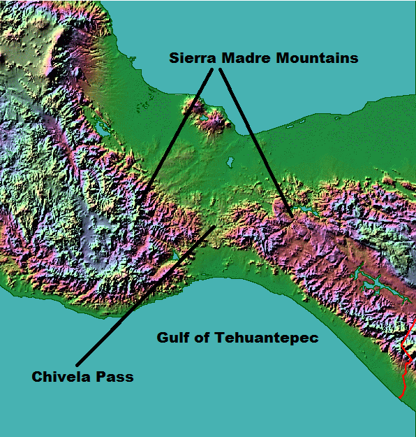
1. The strength of a 3rd Tehuantepec wind gap event
2. The formation and development of #roslyn
3. The strength & timing of an Arctic air blast sth ove the US.
Given these complex variables the latest GFS run understandably has a different outcome - and a much stronger impact from a southerly arctic blast.

Ominously it also shows the development of a new tropical storm off the northern Coast of South America heading into the Carribean.
Here is a 24 hour animation over Southern Mexico and the Eastern Pacific where this stituation is currently developing. Yesterday and overnight it shows spectacular convection over Southern Mexico - which is presumably causing flash flooding.
The convective storms are developing along the coastal and inland mountain ranges of Mexico. and extend up the East coast of Mexico up to the US Border.
Here is a closeup 12 hour animation of these #Mexico rain storms which shows the development so far. This extreme weather rain event is ongoing.

This is providing another variable to the complex #ExtremeWeather synoptic situation - introducing mass water vapour to the Gulf.
Here is the full 18-06 IWVT run from GFS3 which provides additional perspective on this ongoing #ExtremeWeather event. In particular revealing the simulated origin of the storm which we can see in the forecast forming over the Carribean towards the end of the 16 day period.
This storm is simulated to form in the Pacific off the coast of Panama around 22nd-24th October. This clip of part of the full GFS IWVT forecast begins on the 24th and runs till the end on November 3rd.

At this point probably distraction - but it illustrates the complexity.
Completing this long range set up picture of the evolution of this #ExtremeWeather event, here is a North America PWAT simulation from the 18.06 run for the next 16 days.
It appears this persistent pattern over the US may be weakening at long last which, accompanied by the southwards progression of the ICTZ (Equatorial Tropical Water flow) ought to eventually bring an end to this.
The overall causes of this #CentralAmerica #ExtremeWeather event are this pattern of southerly arctic blasts (originating over Canada) and an equinox (sun crossing the equator) boost of tropical water flow from the West African/Tropical Atlantic Monsoon through the Carribean.
/ends

@Threadreaderapp unroll

• • •

Missing some Tweet in this thread? You can try to force a refresh
 

Keep Current with Alastair Thompson

Alastair Thompson Profile picture

Stay in touch and get notified when new unrolls are available from this author!

Read all threads

This Thread may be Removed Anytime!

PDF

Twitter may remove this content at anytime! Save it as PDF for later use!

Try unrolling a thread yourself!

how to unroll video
  1. Follow @ThreadReaderApp to mention us!

  2. From a Twitter thread mention us with a keyword "unroll"
@threadreaderapp unroll

Practice here first or read more on our help page!

More from @althecat

Oct 18
Presently a Cat 2 Typhoon #Nesat/#NenengPH is another massive late season storm forecast to make landfall on Oct 20th in the Gulf of Tonkin south of Hanoi and weaken to a Tropical Storm before doing so. the South China Island of Hainan will likely receive the worst of the storm. Image
Unfortunately the @zoom_earth Hinmawari Satellite imagery is not available. But from the weather radar data we can see that intense rain bands are now coming ashore on the east coast of Hainan, possibly accompanied by hurricane force winds. Image
Read 11 tweets
Oct 18
[#ExtremeWeather #ClimateChangeNow coverage initiation THREAD].
The next potentially devastating northern hemisphere hurrricane candidate #92B has now been designated.
The potential new storm - which is modeled to head north into the Bay of Bengal in coming days and make - has been in global simulation models for several days. This is the latest GFS3 IWVT model run.
#Invest92b #92b GFS3 Model 16 day forecast of precipititable water (PWAT)

With a series of West Pacific tropical storms & typhoons - including #NenengPH [which you can see arriving in Vietnam shortly on upper right] - the Nth. Indian ocean is flooded with water vapour.
Read 7 tweets
Oct 17
With respect, the obstacle to peace is not Eritrean forces who have now withdrawn to Badme and Humera if they were ever in Tigray. The obstacle is TPLF and that is who @antonioguterres ought to be addressing the GoE is ready for a ceasefire and talks.
It is unfortunate that the UNSG has chosen, presumably for political reasons to repeat the TPLF’s age old propaganda talking point, and that as a result 100 million plus Ethiopians will likely see this statement as a cop-out.
This is true. But the obstacle to peace talks has always been the TPLF, who started this war and whose infiltration of and coddling by UN, US and EU diplomats has resulted in their refusing to engage in a peace process for very nearly two years.
Read 8 tweets
Oct 16
No the IC does not have a choice to make. You have a choice to make. Whether to sue for peace or not. Unfortunately this evenings statement is unclear.

This statement clearly undermines what you said in the previous statement. Which was different.

You need to make up your mind.
To spell this out.

"The IC has a choice to make"

&

"We also call on the IC to...."

Are not the same. Words matter. Also the party you are negotiating with is not the IC. It is the legitimate democratically elected and constituted Govt. of Ethiopia.
The assumption that anyone with a clue about this war and TPLF will make from this dissembling is:You are on the threshold of being defeated and you are yet again seeking someone to rescue you.

This will not happen. What can happen is a cessation of hostilities & talks.
Read 5 tweets
Oct 16
#ExtremeWeather #ClimateChangeNOW update THREAD (ongoing coverage)

While Tropical Storm #Karl is finished, the #ExtremeWeather event associated with #HurricaneJulia and #TSKarl is not yet over.
In the animation above you can see the end of #TSKarl #Karl as it, like its parent storm #HurricaneJulia was pushed through the Tehuantepec wind gap into the Gulf of Tehuantepec in the Pacific.
This animation pics up the story over southern Mexico's Pacific coast this afternoon and evening and shows several convective bursts over land. The one at the end on the bottom left hand side is directly over Acapulco.
Read 14 tweets
Oct 16
#ExremeWeather #ClimateChange continuing event coverage initiation.

Vietnam has just seen landfall of a huge Tropical Storm - and now three more cyclones are forecast to follow the same path. The first being #Nemeng. Another slow wet giant storm. Image
Yesterday Typhoon #Sonca made landfall in Vietnam as a Tropical Storm - the 25th named storm of 2022. #Sonca was a huge slow moving wet behemoth like #Ian and #Julia (ATL). This characteristic has been a pattern with many post equinox nth. hemisphere storms. Image
#Sonca has also reportedly caused 4 fatalities already - but the event has only just finished.
Read 8 tweets

Did Thread Reader help you today?

Support us! We are indie developers!


This site is made by just two indie developers on a laptop doing marketing, support and development! Read more about the story.

Become a Premium Member ($3/month or $30/year) and get exclusive features!

Become Premium

Don't want to be a Premium member but still want to support us?

Make a small donation by buying us coffee ($5) or help with server cost ($10)

Donate via Paypal

Or Donate anonymously using crypto!

Ethereum

0xfe58350B80634f60Fa6Dc149a72b4DFbc17D341E copy

Bitcoin

3ATGMxNzCUFzxpMCHL5sWSt4DVtS8UqXpi copy

Thank you for your support!

Follow Us on Twitter!

:(