The upcoming Arctic outbreak across Central U.S. is going to be the "real deal". Temperatures will likely rival anything seen in 30 years (or even longer!) across portions of the Central Plains. In a warming climate, that's saying quite a lot. #COwx#NEwx#WYwx#KSwx (1/6)
Temperatures will fall, in incredibly dramatic fashion ( of the course of just a few hours) by 40 or more degrees in some areas as a powerful Arctic front pushes through. Temperatures will plummet well below zero (-20 to -30F) across a broad region, w/even lower windchills. (2/6)
This level of cold will be potentially dangerous even in places accustomed to pretty low temperatures in winter, since even those spots haven't seen temperatures this low in 30 or more years. This will be especially true across portions of Wyoming and Colorado. #WYwx#COwx (3/6)
One personal reflection as a climate scientist currently living in Boulder: it's plausible that these are the coldest temperatures I'll experience in this part of the world for the rest of my life, given the strong and sustained winter warming trend due to #ClimateChange. (4/6)
Winters across essentially the entire U.S. have been getting warmer in recent decades, with decreases in both the duration and magnitude of extreme cold in most places. #ColdSnap#ClimateChange#ArcticBlast (5/6)
Finally, a brief note about amplified Arctic warming & its influence on mid-latitude cold snaps: right now, evidence suggests that although warming Arctic may well have regional/seasonal effects on jet stream, it's probably not causing more extreme winter cold in N. America.(6/6)
• • •
Missing some Tweet in this thread? You can try to
force a refresh
Still not seeing many images of damage, but based on anecdotes from folks in quake zone it does sound like there was damage to some structures & especially to infrastructure. I suspect that ongoing widespread regional power outages are reason we haven't heard more yet.#earthquake
This points to an emerging paradox in media reporting on disasters that's become really apparent in recent years: the more severe the damage, the less news initially makes it out (because power is out and telecoms are down) and the less coverage they receive.
In our hyper-connected information era, it often feels like there's a presumption that if something was a big deal, it must be prominent on social media (& if it's not, it's not a big deal). But that assumption breaks down if people can't get online in the worst-affected areas...
To @JFrancisClimate's point, there has been some interesting recent work suggesting that amplified Arctic warming may be causing the *stratospheric* polar vortex to become disrupted more often in winter. But this is still the topic of very active research. science.org/doi/10.1126/sc…
And there's further evidence that Arctic warming may be associated w/jet stream patterns favorable for warm season weather extremes. So my view is that there is something going on! It just doesn't appear to be manifesting as colder winter extremes. science.org/doi/10.1126/sc…
BTW, my personal/professional view, essentially informed speculation, is actually that we're going to eventually confirm that Arctic amplification/sea ice/snow cover/high lat ocean temperature forcings are quite important in certain regions/seasons (including California!).
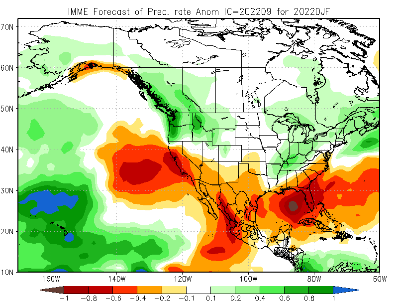
Latest seasonal predictions from NMME/IMME ensembles out today. Overall North Pacific pattern still looks very #LaNina-like: unusually wet PacNW and BC; unusually dry in SoCal & Lower Colorado Basin due to persistent NE Pacific ridging. HOWEVER... #WAwx#CAwx#AZwx (1/4)
...However, exact position of N. Pac. ridge is key. Too far east, & CA stays dry, but far enough west & Sierra benefits from cold storms diving south. High confidence in winter ridge, but CA will be on razor's edge--exact position will dictate dry vs wet overall. (2/4)#CAwx
This is why seasonal prediction is hard. It's quite likely models are correct about strong, anomalous North Pacific ridge signal (mainly due to #LaNina). But that doesn't directly translate to CA precip--it only offers a modest tilt in odds toward dry winter. #CAwx#CAwater (3/4)
The coming week is shaping up to be a pretty crazy weather week in California, TBH--even more so than previously thought. Ongoing heatwave expected to be longer & peak even higher, & now we have potential influence of a soon-to develop hurricane to consider. (1/n) #CAwx#CAfire
First, exceptional daytime & nighttime heat (plus high humidity) continues across SoCal today. Some places may see all-time record warmest overnight temps today. In northern California, much drier heat is building,& temperatures will continue to rise further for days. (2/n) #CAwx
Interior Northern California is now heading for a truly dangerous, searing heatwave. All-time September records are now all but guaranteed in the Central Valley (on multiple consecutive days!), and all-time (any month) records now appear well within reach. #CAwx#CAfire
In this work, we develop a pair of plausible extreme, month-long winter storm sequences in California--one from the recent historical climate, and one from a much warmer future climate. These sequences involve a multi-week series of successive #AtmosphericRiver storms. (3/n)
We assess regional-scale atmospheric conditions favorable for dry lightning in central & northern California (N&C CA), as well as seasonality. We find that nearly half of all lightning strikes in N&C CA are "dry" (accompanied by <0.10 in. of rain). (2/n) iopscience.iop.org/article/10.108…
In some locations, including most of the San Francisco Bay Area, North Coast, and portions of Southern Sierra, fully 60-80% of May-Oct cloud-to-ground lightning strikes occur as dry lightning! Major implications for wildfire risk. (3/n) #CAwx#CAfireiopscience.iop.org/article/10.108…