First cloud-free #Sentinel2 satellite images in a month dropped yesterday. Great to check out snow levels, reservoirs, and wet wet wet in the Butte Basin/Lower Sacramento River. First image compares Colusa area now vs 12/15/2022. #Geography #RemoteSensing #CaWx #CaStorm 1/x
Imagery paints a picture of soil types. Along the River, coarser soils settle quickly once floodwaters slow down. Blue areas have more clay, because super-fine soil particles can stay suspended longer, travel farther in slow-moving floodwaters. Orchards prefer coarse soils. 2/x
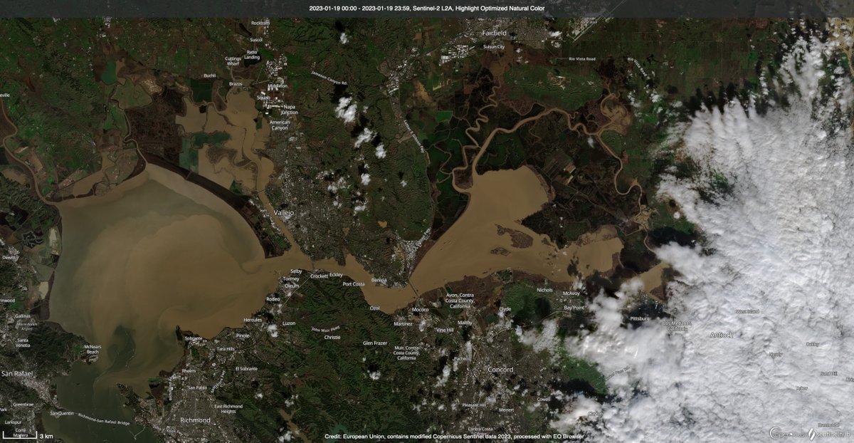
Plumes of sediment from the Pajaro and Salinas Rivers are still very visible in the Monterey Bay on 1/19/2023. Two visualizations of sediment in the lower Delta and San Pablo Bay. 3/x
This image shows rice fields in the Northern Sacramento Valley (blue areas). Similarly to the Butte Basin, rice lands in Yuba County (lower-left) are in the longterm floodplain of the Feather and Yuba Rivers while orchards predominate in coarse soils along the Feather River. 4/x
Reservoir levels at Lake Shasta and Lake Oroville - 12/15/22 vs 1/19/2023. #CaWx #CaStorm #CaWater #Sentinel2 5/x
The 'tailwater' from rice on the west side of the Sac Valley (south of about Willows) eventually ends up in the main 'Westside Drain' which dumps back into the Sac River around Knights Landing. This foaming brew flows into the Delta and we pump it south for people to drink. 6/x

• • •

Missing some Tweet in this thread? You can try to force a refresh
 

Keep Current with Zeke Lunder ~ The Lookout

Zeke Lunder ~ The Lookout Profile picture

Stay in touch and get notified when new unrolls are available from this author!

Read all threads

This Thread may be Removed Anytime!

PDF

Twitter may remove this content at anytime! Save it as PDF for later use!

Try unrolling a thread yourself!

how to unroll video
  1. Follow @ThreadReaderApp to mention us!

  2. From a Twitter thread mention us with a keyword "unroll"
@threadreaderapp unroll

Practice here first or read more on our help page!

More from @wildland_zko

Nov 10, 2020
It's been two years since the #campfire burned here in Butte County. This thread is a narrative about the fire with satellite images I created of the fire at the peak of it's rampage, and aerial photos we flew. This image shows the long-range spotting which spread the fire. 1/x
The fire started in the Feather River Canyon, near Pulga, and raced up Flea Valley Creek. Once the fire reached the rim of the Canyon, it rained embers all over the Concow Basin. It raced thru heavy fuels in the Concow area, which still had tall dead brush from fires in 2008. 2/x
By the time the leapt across the West Branch Feather River, it was nearly 5 miles wide. Every bright yellow dot in this image is a burning structure. This view looks North. Fire spread from right to left. 3/x #WUI #planning #paradiseca
Read 9 tweets

Did Thread Reader help you today?

Support us! We are indie developers!


This site is made by just two indie developers on a laptop doing marketing, support and development! Read more about the story.

Become a Premium Member ($3/month or $30/year) and get exclusive features!

Become Premium

Don't want to be a Premium member but still want to support us?

Make a small donation by buying us coffee ($5) or help with server cost ($10)

Donate via Paypal

Or Donate anonymously using crypto!

Ethereum

0xfe58350B80634f60Fa6Dc149a72b4DFbc17D341E copy

Bitcoin

3ATGMxNzCUFzxpMCHL5sWSt4DVtS8UqXpi copy

Thank you for your support!

Follow Us on Twitter!

:(