
🚨 New Publication 🚨
The River Corridor Critical Zone.
High level: River corridors ARE critical zones, & studying them as such is to the benefit of both communities
A 🧵of some high-points
frontiersin.org/articles/10.33…
#river #CriticalZone #hydrology
The River Corridor Critical Zone.
High level: River corridors ARE critical zones, & studying them as such is to the benefit of both communities
A 🧵of some high-points
frontiersin.org/articles/10.33…
#river #CriticalZone #hydrology
How has the river corridor already been studied as an integrated system? Why is the CZ approach appropriate for river corridors? What elements of the CZ approach are lacking in river science? What opportunities would the CZ approach bring to of river corridors?
The CZ is a continuum from uplands to convergent locations. While uplands are highly represented in CZ science, they are not the only landscape element of the CZ.
We propose organizing our work along a continuum, and considering interactions along the gradient.
We propose organizing our work along a continuum, and considering interactions along the gradient.

How did we get here? At least 81 unique conceptual models in river science have been posed, spanning physical, biological, & chemical processes and the feedbacks and dynamics that link them on the landscape.

Were river corridors the original critical zones? In some ways yes. Multi-scale, multi-disciplinary, coupled process dynamics. Here's what those conceptual models studied in terms of dimension(s) of connectivity, spatial scale, temporal scale.

Were river corridors the original critical zones? In other ways, not so much. Very little linkage to provisioning and cultural services, much more emphasis on supporting and regulating services. River science has not fully explored 'critical to whom and for what reasons?'

Methodological aside:
(1) we limited ourselves to the 'key paper' itself for each conceptual model, not where it was subsequently applied
(2) the services in each conceptual model were organized using this paper as a guide
acsess.onlinelibrary.wiley.com/doi/10.2136/vz…
(1) we limited ourselves to the 'key paper' itself for each conceptual model, not where it was subsequently applied
(2) the services in each conceptual model were organized using this paper as a guide
acsess.onlinelibrary.wiley.com/doi/10.2136/vz…
Opportunities for River Corridor Critical Zone science:
Opportunity 1: investigate local-scale processes in the context of larger-scale spatial gradients.
Rivers couple large/slow processes and smaller/rapid dynamics. We need to explicitly link these. #MacroSystems
Opportunity 1: investigate local-scale processes in the context of larger-scale spatial gradients.
Rivers couple large/slow processes and smaller/rapid dynamics. We need to explicitly link these. #MacroSystems
Opportunity 2: embrace that river corridor processes are temporally variable and interacting
We need to get over concepts like stationarity, 'at baseflow', or 'average annual' in favor of studying dynamic interactions. This is enabled be emerging sensors & data science
We need to get over concepts like stationarity, 'at baseflow', or 'average annual' in favor of studying dynamic interactions. This is enabled be emerging sensors & data science
Opportunity 3: river corridor functions do not respect disciplinary boundaries. Our science can reflect this reality by emphasizing integrated, multidisciplinary investigations
Lets lean into integrated, many-disciplinary studies & data analysis.
Lets lean into integrated, many-disciplinary studies & data analysis.
Opportunity 4: explicit integration of humans and their management actions beyond just the alteration of discharge
River management & river science have, in many cases, bifurcated. We need to explicitly engage with & account for management regimes
River management & river science have, in many cases, bifurcated. We need to explicitly engage with & account for management regimes
Organizing our understanding of the river corridor
In the first figure in our thread (here again), we propose a strategy for organizing our understanding. How can we use this moving forward?
In the first figure in our thread (here again), we propose a strategy for organizing our understanding. How can we use this moving forward?

We propose using this as the essential 'building block' for understanding. For a given process / function / service, we can describe the most important controls as a function of network location, flow condition, management regime, geological setting, etc.
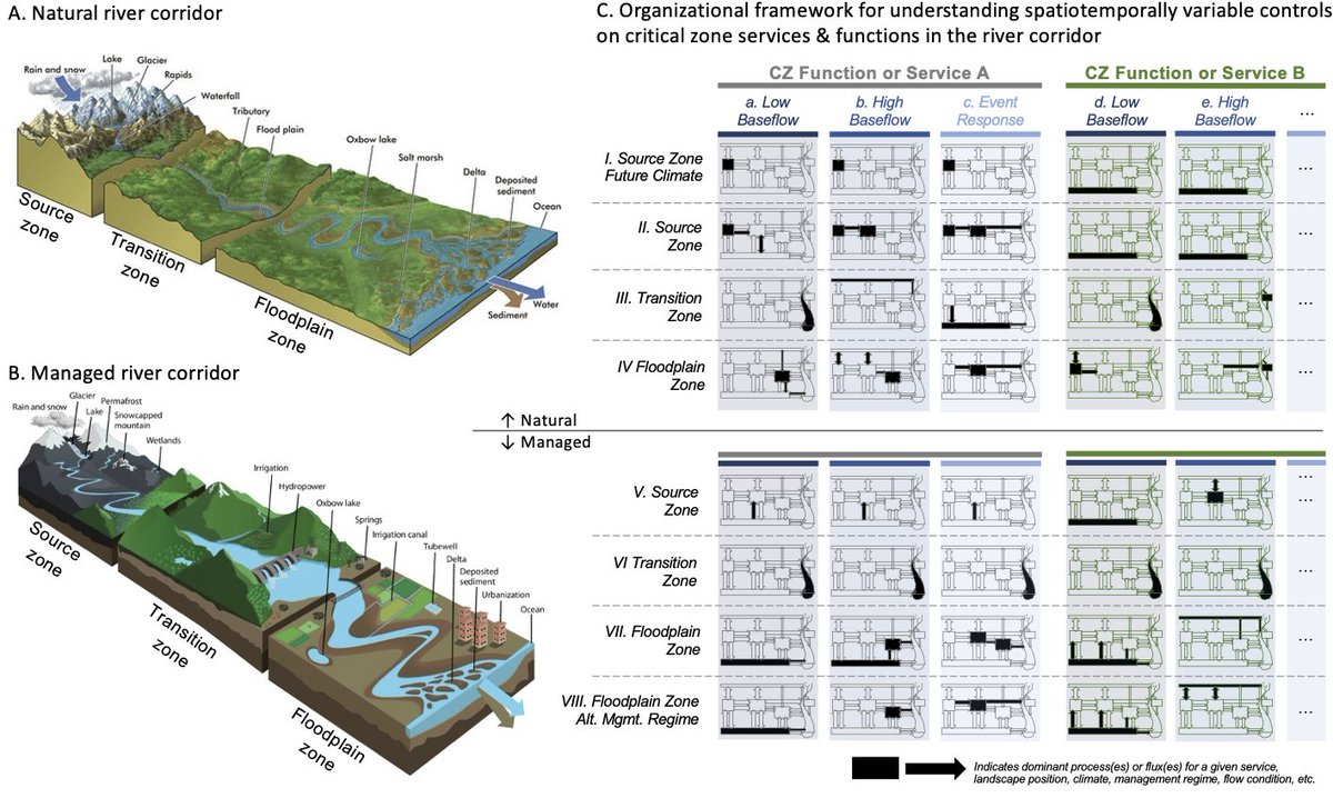
This conceptual framework would enable river scientists to build a comprehensive, transferable understanding that organizes our knowledge with an emphasis on the dominant-process approach to modeling.
👆 The prior image might be considered a river corridor update to this famous image from @BrantleyPSU @Chorover1 et al. We still need the coverage across climate, lithology, etc. but also require stratification along the river corridor
czo-archive.criticalzone.org/national/publi…
czo-archive.criticalzone.org/national/publi…

The overarching objective of this review and perspective is to assert that river corridors are unique landforms within Earth's critical zone with important boundaries and dynamics worthy of integrative and multidisciplinary study.
While the evolution of river science has embraced some tenets of the CZ approach (e.g., multi-scale, function/service oriented), gaps clearly remain.
We emphasize that river corridor science IS critical zone science, and arguably has reflected dimensions of the CZ before the term “critical zone” was coined.
River corridor scientists must embrace the tenets of critical zone science, specifically, that the geologic template and climate interact to determine structural and functional aspects of the CZ while incorporating time scales from seconds to millennia
We recognize river corridors as key functional elements within the CZ, serve as integrators of upland exports, and as connectors along the summit-to-sea continuum allowing for the effective integration of systems across the CZ.
Ok - you've got the link if you want to read more of our perspective.
doi.org/10.3389/frwa.2…
Acknowledgements:
First, co-authored by Ellen Wohl, Adam Wymore, & Jud Harvey. An outstanding river science braintrust.
doi.org/10.3389/frwa.2…
Acknowledgements:
First, co-authored by Ellen Wohl, Adam Wymore, & Jud Harvey. An outstanding river science braintrust.
These ideas didn't spring up out of nowhere. This originated from lots of conversations & a proposal effort including awesome scientists like:
@BalesJerad @aaberhe Neal Blair @burginam @DrAquaMatt @TimCovino @HoosierRiver Sarah Godsey @FroudeNum @DrNitrogen ...
@BalesJerad @aaberhe Neal Blair @burginam @DrAquaMatt @TimCovino @HoosierRiver Sarah Godsey @FroudeNum @DrNitrogen ...
...Bob Hall, @CiaranJHarman @skuylerherzog Diana Karwan, Charlie Luce, Aaron Packman, Colin Phillips, @ToddVRoyer @JamesStegen, Ate Visser, @awilcoxgeomorph @WilWollheim, Steve Wondzell, @GeomorphYuggs @jlandonyoder @Hydro_DoctorJ
@CiaranJHarman @skuylerherzog @ToddVRoyer @JamesStegen @awilcoxgeomorph @WilWollheim @GeomorphYuggs @jlandonyoder @Hydro_DoctorJ @threadreaderapp unroll
• • •
Missing some Tweet in this thread? You can try to
force a refresh


