
2 0 Y E A R S OF MUMBAI FLOODS (26/7):
Revisiting Mithi river two decades after Mumbai’s worst deluge. We at @TOIMumbai travelled through the entire 17.8 km stretch of Mithi river starting out from Vihar lake upto Mahim causeway. Here’s our account of what’s truly changed, what remains stuck, and whether Mumbai is any closer to taming its most talked-about urban waterway.
Report, Pics & Graphics: @winterapples @richapintoi @ShanthkumarSl & Ram.

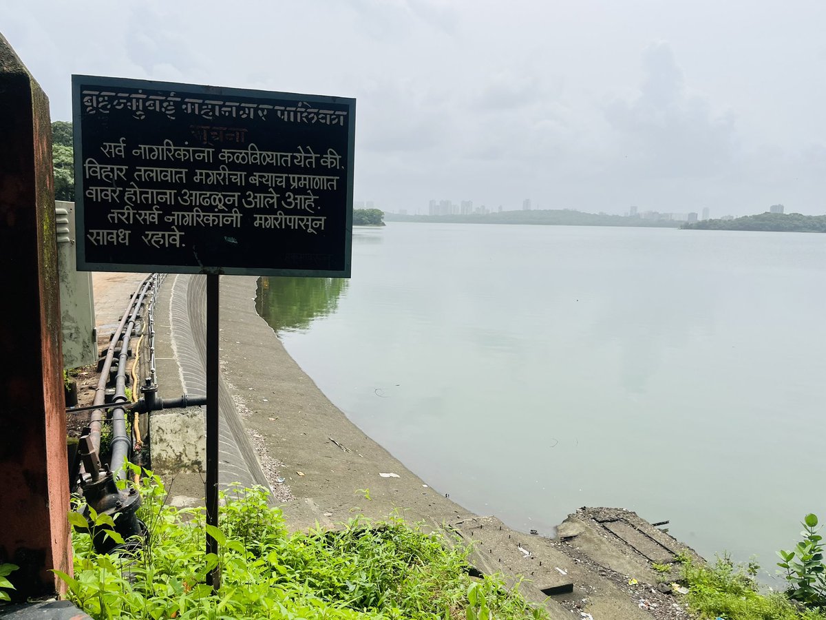
Point 1: The starting point: Vihar Lake, Powai
To pinpoint the exact origin of the Mithi River, one must access the high-security premises of Vihar Lake, where its spill directly feeds into the river. While Powai Lake also contributes to the Mithi, its overflow is visible further downstream. Within the Vihar Lake premises, a high retaining wall, metal grills, and a wide tiled pathway mark the point where the overflow begins its descent into the Mithi. When Vihar overflows, its excess water flows directly into the Mithi river.
To pinpoint the exact origin of the Mithi River, one must access the high-security premises of Vihar Lake, where its spill directly feeds into the river. While Powai Lake also contributes to the Mithi, its overflow is visible further downstream. Within the Vihar Lake premises, a high retaining wall, metal grills, and a wide tiled pathway mark the point where the overflow begins its descent into the Mithi. When Vihar overflows, its excess water flows directly into the Mithi river.
Point 2: Filterpada, Powai.
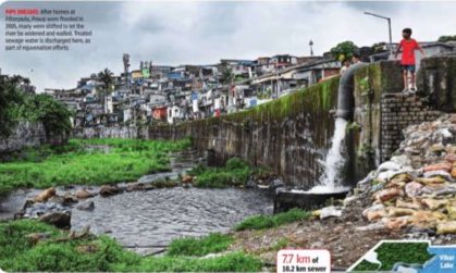
As one enters Filterpada, an area severely impacted during the 2005 deluge, a newly constructed retaining wall and service road now allow both vehicles and pedestrians to access the starting stretch of the Mithi River, where the Vihar Lake spill flows into it. The locality, densely packed with informal homes—many rising one storey high—still bears the scars of that devastating flood.
As one enters Filterpada, an area severely impacted during the 2005 deluge, a newly constructed retaining wall and service road now allow both vehicles and pedestrians to access the starting stretch of the Mithi River, where the Vihar Lake spill flows into it. The locality, densely packed with informal homes—many rising one storey high—still bears the scars of that devastating flood.
Point 3: Sewerage Treatment Plant, 8 MLD (Eight million litres per day)
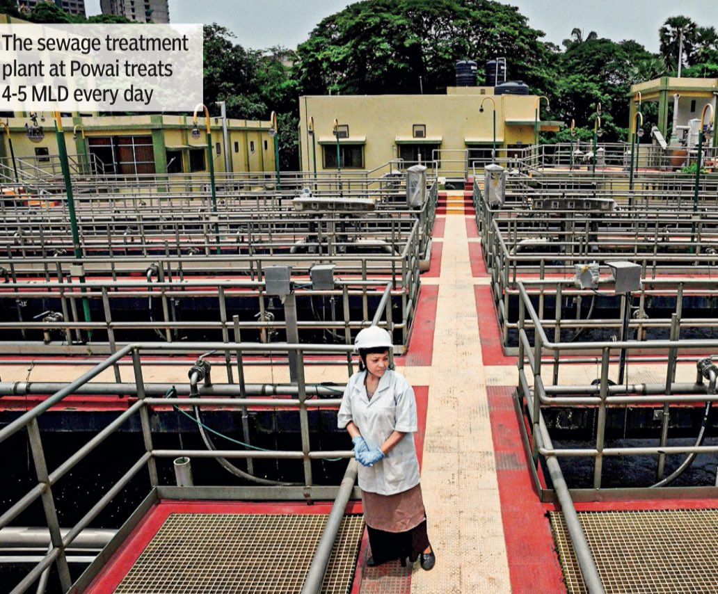
Downstream from Filterpada, an 8 MLD (million litres per day) Sewage Treatment Plant (STP) has been set up, currently treating around 4–5 MLD of wastewater daily. From the top of the STP, one can also view Powai Lake’s overflow feeding into the Mithi River at this point.
The primary function of this STP is to intercept sewage flowing into the Mithi from multiple outfalls and divert it into municipal sewage lines for treatment.
Point 4: Jogeshwari Vikrohli Link Road (JVLR) opposite the Aarey Colony metro station:
Crossing over to the opposite side of the Aarey Colony Metro Station on JVLR one finds a significantly widened stretch of the Mithi River, now spanning up to 40 metres at this point. Retaining walls have been constructed along the banks of the river here too. However what remains incomplete is the sewer line connection.
Crossing over to the opposite side of the Aarey Colony Metro Station on JVLR one finds a significantly widened stretch of the Mithi River, now spanning up to 40 metres at this point. Retaining walls have been constructed along the banks of the river here too. However what remains incomplete is the sewer line connection.
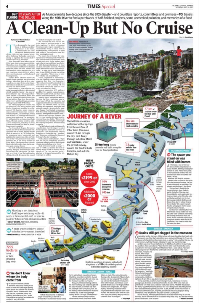
Point 5: KBM Compound, Marol
This stretch of the river is densely flanked by encroachments, many of which have been cleared in large-scale demolition drives carried out in 2007, 2013, and most recently in 2023, following the aftermath of the 2005 deluge. Despite repeated actions, civic officials say encroachments continue to reappear.
This stretch of the river is densely flanked by encroachments, many of which have been cleared in large-scale demolition drives carried out in 2007, 2013, and most recently in 2023, following the aftermath of the 2005 deluge. Despite repeated actions, civic officials say encroachments continue to reappear.
Point 6: Saki Naka, Andheri.
At Saki Naka in Andheri, the Mithi River runs close enough to the airport that landed aircraft can be seen from a distances. Along this stretch, a mix of encroachments and new private developments line the riverbanks—some just a few metres away from the water.
At Saki Naka in Andheri, the Mithi River runs close enough to the airport that landed aircraft can be seen from a distances. Along this stretch, a mix of encroachments and new private developments line the riverbanks—some just a few metres away from the water.
Point 7: Tunnel shaft construction site, Saki Naka.
A few metres from the Mithi River at Saki Naka, a large section of the road remains barricaded for the construction of a tunnel shaft, which is a component of the BMC’s Mithi River Water Quality Improvement Project.
The purpose of this tunnel shaft is to divert 168 MLD (million litres per day) of sewage currently entering the Mithi River from two major drains—Bapat Nullah in Andheri and Safed Pul Nullah in Kurla. Instead of discharging into the river, this untreated sewage will be redirected to the Dharavi Wastewater Treatment Facility (WWTF) via a 2.6-metre diameter tunnel stretching 6.8 kilometres beneath the LBS Road corridor
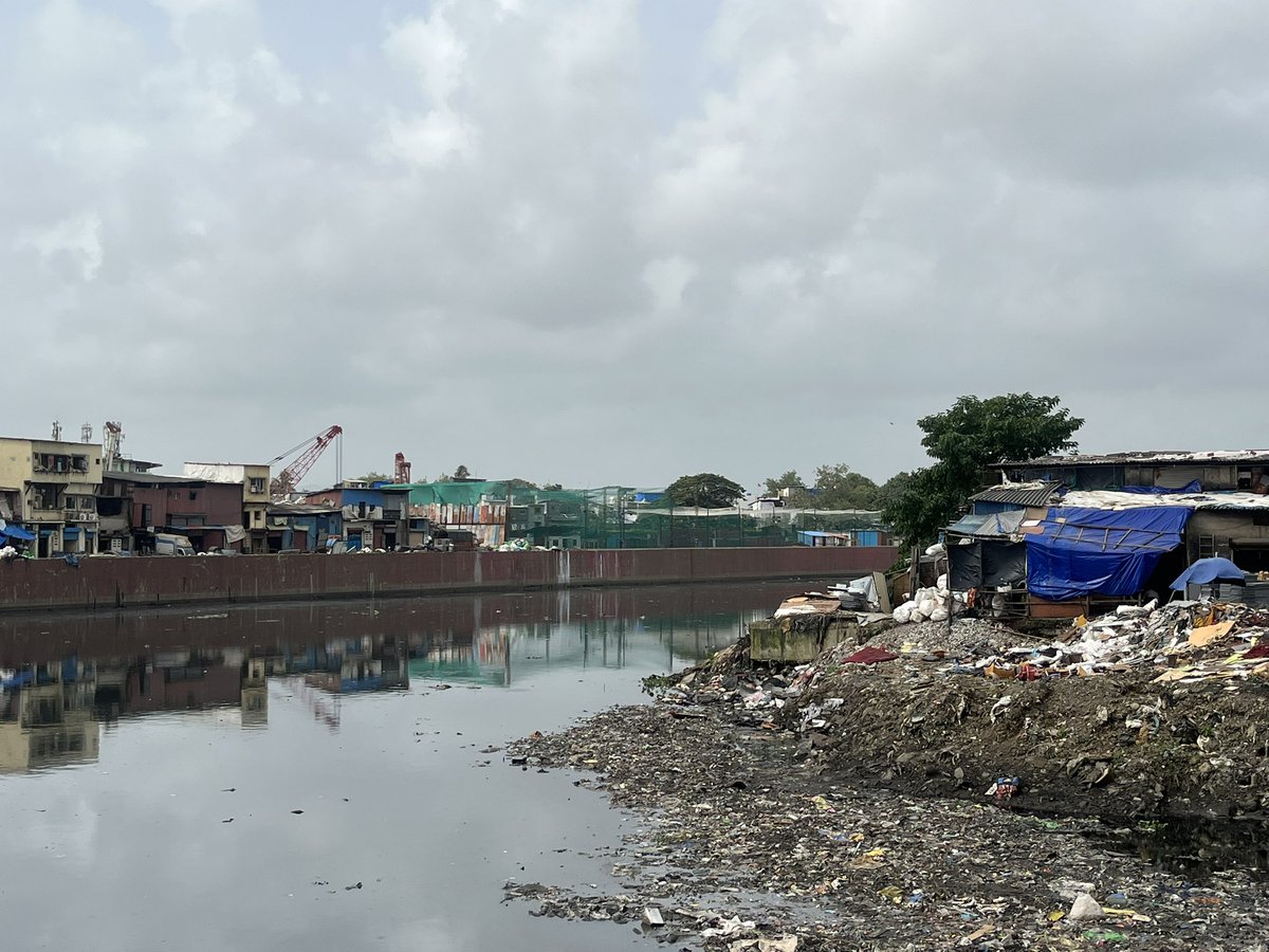
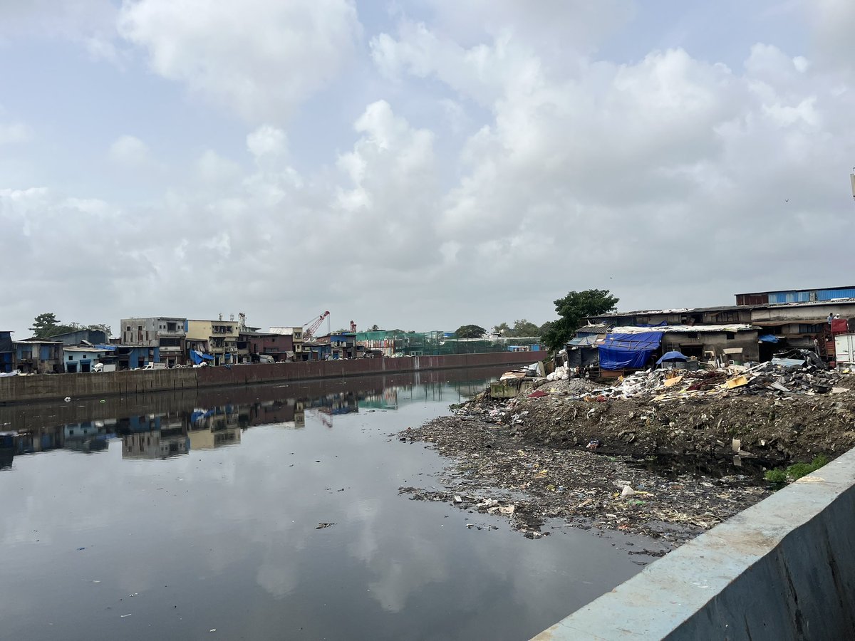
Part 8: CST bridge at Kurla
At the CST (Central Salsette Tramway) Bridge in Kurla, the Mithi River remains heavily encroached upon, particularly by sections of the Kurla scrap market, which still spill over into the river’s path. The riverbanks in this area are flanked by dense slum pockets, notably Kismat Nagar and BakshisingCompound, which continue to pose challenges to any river rejuvenation efforts.
At the CST (Central Salsette Tramway) Bridge in Kurla, the Mithi River remains heavily encroached upon, particularly by sections of the Kurla scrap market, which still spill over into the river’s path. The riverbanks in this area are flanked by dense slum pockets, notably Kismat Nagar and BakshisingCompound, which continue to pose challenges to any river rejuvenation efforts.
Point 9: Kurla along Bandra Kurla Complex (BKC) Connector.
This stretch of the Mithi River flows directly beneath the newly constructed BKC Connector, bridging Bandra-Kurla Complex on one side and Mahim Nature Park and its surrounding mangroves on the other. The landscape here is distinct, marked by a dense mangrove cover and marshy terrain, making conventional civil works more complex.
This stretch of the Mithi River flows directly beneath the newly constructed BKC Connector, bridging Bandra-Kurla Complex on one side and Mahim Nature Park and its surrounding mangroves on the other. The landscape here is distinct, marked by a dense mangrove cover and marshy terrain, making conventional civil works more complex.
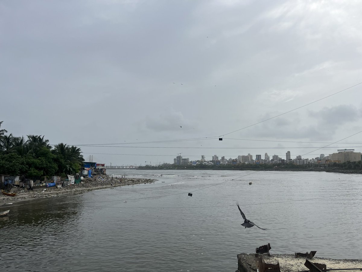
Point 10: Mahim
At Mahim Causeway, the Mithi River completes its journey, emptying into the Arabian Sea through the Mahim Creek. This confluence is a wide, open estuarine stretch where the river’s freshwater flow meets the tidal saltwater of the sea. This is also very evident from the salty sea water smell one gets as compared to the raw effluent filled water that one smells of Mithi river at the other stops.
E. N. D. S.
• • •
Missing some Tweet in this thread? You can try to
force a refresh


