
1. We lived in St Louis county when I was a young. My dad would take off when ever there were tornadoes around. He was an @AP photographer and wanted to get a photo. So as children we were acutely aware of the weather. In Sept 1992 our sons were infants. I'd been tracking Iniki
2. with a shortwave radio and graph paper. I saw it turn north all of a sudden in the middle of the night. Cat 4 and less than a day away. So at about 2:00 am I rushed to Foodland and stocked up. Nobody there was even aware there was a storm coming. Returned home and the
3. phone rang. It was my brother John. He had just about ten days before experienced a life altering 8 hours in a closet with a mattress over him as he rode out Andrew in Kendall district of Miami. John was not one to show excitement but he said "Get the kids out there." I said,
4. "John, we live on an Island 2,300 miles from mainland. There's no place to go." He paused. Thought, then said. "Oh! That's right. Oh well. Good luck." So the reason I'm telling this little anecdote is I will report on the storm, I'm not an expert I'm a storm watcher.
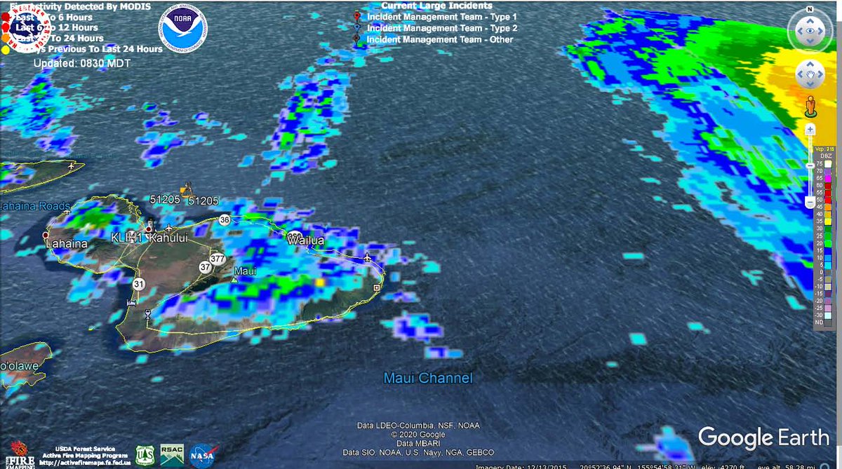
5.Maui may start to see effects in the next three to four hours if still at 17 mph. I wonder if anyone is up in #Hana? The 5:00am report is coming soon. 
6. 5:00 a.m. report.
Of particular note: " Also of extreme value is the fact that
the low-level center is south of the apparent center seen in conventional satellite imagery, and closer to the islands than might be otherwise expected."
weather.hawaii.edu/tropical/advis…
Of particular note: " Also of extreme value is the fact that
the low-level center is south of the apparent center seen in conventional satellite imagery, and closer to the islands than might be otherwise expected."
weather.hawaii.edu/tropical/advis…
7. "Douglas will pass dangerously close to, or over, the islands today, bringing a triple threat of hazards, including but not limited to damaging winds, flooding rainfall, and dangerously high surf, especially along east and north facing shores."
6. Local news has a report from Hauula on Oahu's north east shore. Reporter said it doesn't look like anyone is preparing. He's by the beach and it's business as usual with folks fishing in the dark.
8. Hawaii KHNL reporting about how officials will handle #covid19 positive people in shelters. I don't think somebody has thought this through. Positive folks need to be isolated. Not put in a group shelter. @GovHawaii @MayorKirkHNL
9. Report from Kalani English in Hana. That's where I think it will get bad soon. Radar returns are not acurate. High ground level winds are ahead of what appears as storm structure on radar because the radars are picking up the tops that are being pushed back away from @Maui.
5. After #HuricaneAndrew Janet Reno opened an investigation that my brother headed to look into whether building code practices led to so much damage. I think the codes were moving towards higher standards but the prince of f-ing darkness helped advance the ball.😎
10. Local news on Hurricane Ewa in 1982. I came here end of 1979. I knew the GM at the Sheraton Poipu and had stayed as his guest.. I ran into him after hotel was scrubbed clean. WWII vet said he thought they'd ride it out. Survived in a closet. Almost cried when he spoke of it.
11. 11:00 am HST NWS CPHC Honolulu update:
"Hurricane Hunters from the Air Force 53rd Weather Reconnaissance Squadron are back out sampling Douglas. The hurricane has been resilient, with deep convection persisting to the west and north of the center
"Hurricane Hunters from the Air Force 53rd Weather Reconnaissance Squadron are back out sampling Douglas. The hurricane has been resilient, with deep convection persisting to the west and north of the center
12. under increasing vertical wind shear. The Hurricane
Hunters have found that the center pressure has risen slightly, and a blend of SFMR and adjusted flight level winds supports lowering the initial intensity to 75 kt. Island-based radars are detecting the mid-level
Hunters have found that the center pressure has risen slightly, and a blend of SFMR and adjusted flight level winds supports lowering the initial intensity to 75 kt. Island-based radars are detecting the mid-level
13. circulation of Douglas, which could be tilted slightly to the north due to the wind shear."
FORECAST POSITIONS AND MAX WIND
INIT 26/2100Z 21.2N 155.7W 75 KT 85 MPH
12H 27/0600Z 21.8N 158.0W 70 KT 80 MPH...NEAR OAHU
24H 27/1800Z 22.6N 161.0W 65 KT 75 MPH
FORECAST POSITIONS AND MAX WIND
INIT 26/2100Z 21.2N 155.7W 75 KT 85 MPH
12H 27/0600Z 21.8N 158.0W 70 KT 80 MPH...NEAR OAHU
24H 27/1800Z 22.6N 161.0W 65 KT 75 MPH
14. In 1985 I was in the eye of a cat 1 hurricane when Gloria went over Western MA. My friend called me while we were in the eye and said he was relieved we made it. I told him we were in the eye and the wind will now come from the other direction. He blew it off and hung up.
15. About 10 minutes later he called me back in a panic: "My trees are down!" I think this one is coming close to Oahu. Be careful of old grown trees in places like Manoa.
16. Honolulu Convention Center is open for evacuation. Seems they still have room. It's walking distance from @TrumpHotels Waikiki. They're both on the Ala Wai. I'd think a surge could back up in there but I guess they know what they're doing.
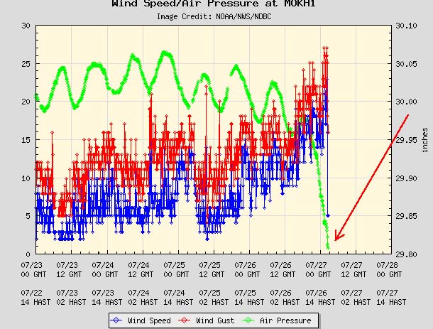
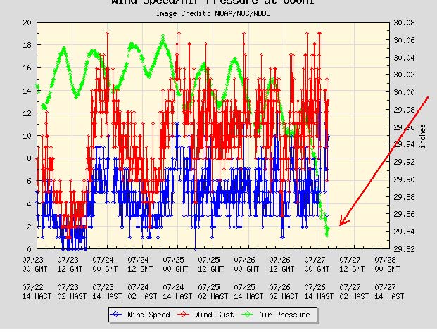
17. Though the jog north has forecasters starting to relax I see band about to make shore on north Shore and two buoys, Kaneohe (left) and south shore (right) are both falling. So I'm still not blowing the all-clear. #kauai
18. Local news confirming Oahu's north shore getting heavy rain.
19. They also reported on the sunset that was an odd umber glow. Strange.
20. #hurricanedouglass is doing a little eye shifting. It may be a replacement cycle, but I also occasionally see where the eye changes to a less defined center and then the eye reapears popping up 90 degrees from original course position. Kauai should keep a weather eye tonight.
21. I think outer bands should be reaching the east side of Kauai soon. there is also a slight drop off in intensity based on cloud tops.

