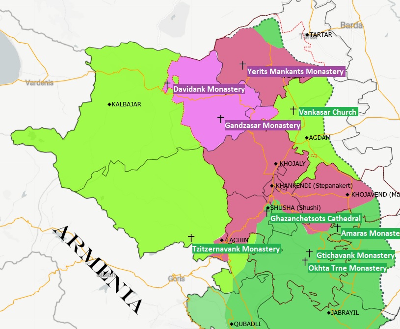
1/ New Map of Northern #Karabakh military control after Nov 9th agreement btw #Azerbaijan #Armenia and Russia
get HD map here : drive.google.com/file/d/1mW_7SI…
get HD map here : drive.google.com/file/d/1mW_7SI…

2/ For this map, I used current Azerbaijan districts limits, as they are different from USSR era. The Northern Karabakh (suppressed in 1991) limits have also been added as they have obviously been used as a basis in nov 9 agreement
3/ For example, Kalbajar district should be evacuated and transferred to AZ control before Dec 15, but the Eastern part which was in the former Oblast seems to be excluded and under Russian Peacekeeping force protection
4/ It is the same for a small part of Agdam district. That district is also a question mark as it should be back under Azerbaijan control before Dec 1, but the Russians seem to have included it in their peacekeaping area of operations
Please feel free to reuse this map in your tweets or other publications
5/ There are several questions to solve following this agreement, especially the roads. Kalbajar and Lachin districts access will only be possible via Russian controlled areas. It is the same problem for Shushi / Shusha town where there is no usable road from Az ctrled areas
6/ I added on the map the most famous Armenian Christian worship places. It shows that most of them are already or will fall in Azerbaijan control 

There is a mistake on the map : it’s Dadivank monastery not « Davidank ». Sorry for that
• • •
Missing some Tweet in this thread? You can try to
force a refresh


