Strong signs of a potential #volcano #eruption near #Keilir on #Reykjanes peninsula. Scientists reporting #earthquake patterns that are similar to the start of an eruption. Eruption likely to start within the next few hours. 

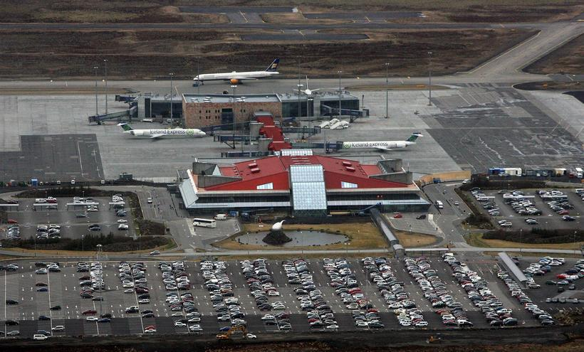
The ICAO airport code for @kefairport and #Reykjavik airport have been raised to Orange - which indicates a high likelihood of imminent eruption. Rescue teams are being put on standby. Coast Guard @gaeslan helicopter to fly over the area shortly. Press briefing scheduled for 1600
This potential eruption is not expected to cause any damage to infrastructure and towns/cities according to @almannavarnir. The eruption has not yet started and is far away from habited places.
People are asked not to attempt going into the area close to the potential eruption location. Scientists in the area are evacuating. No immediate plans to stop traffic to #Reykjanes - but the airport will close for up to 1 hour once an eruption is confirmed based on ICAO protocol
Two webcams pointing towards the Keilir #eruption area (unfortunately very cloudy and wet right now):
From Reykjavik: ruv.is/frett/2021/03/…
From Keflavik:
From Reykjavik: ruv.is/frett/2021/03/…
From Keflavik:

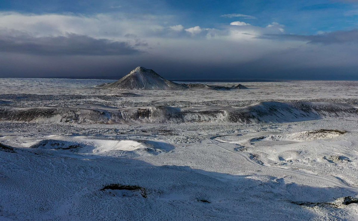
According to scientists at @Vedurstofan a typical "eruption tremor pulse" started at 14:20 GMT near Litli-Hrutur which is halfway between #Keilir mountain and #Fagradalsfjall - right in the path of the #magma chamber they had pointed out. The name means "Little-Ram" 😃

A newly updated lava flow model has been run by @Haskoli_Islands scientists - it shows very limited flow compared to earlier predictions.

The Coast Guard @gaeslan helicopter has not seen any signs of #magma reaching the surface, so no confirmed #eruption yet. Scientists say data shows the magma is breaking its way towards the surface. #LittleRam #Keilir

The tremor pulses have slowed down but scientists still believe #eruption will start in the next few hours (max days) - although still possible everything stops. All roads into the area have been closed and people banned from entering the area around #Keilir

Due to possible #eruption in #Reykjanes peninsula #police (@logreglansudnes) has banned all use of drones in an area marked by Reykjanesbraut, Grindavikurvegur, Krisuvikurleid & Sudurstrandarvegur. This is for the safety of helicopters, first responders, and scientific teams.

Accounts to follow for #Reykjanes #eruption info:
@almannavarnir @VidirReynisson
@raudikrossinn @Landsbjorg
@logreglan @logreglansudnes @gaeslan @Slokkvilidid
@Vedurstofan @uni_iceland @LavaCentre @Vegagerdin
@krjonsdottir @RagnarHeidar @elinbjon @DJCManns
1/2
@almannavarnir @VidirReynisson
@raudikrossinn @Landsbjorg
@logreglan @logreglansudnes @gaeslan @Slokkvilidid
@Vedurstofan @uni_iceland @LavaCentre @Vegagerdin
@krjonsdottir @RagnarHeidar @elinbjon @DJCManns
1/2
Accounts to follow for #Reykjanes #eruption info:
@sandrasnaebj @Iceland_Review @IcelandMonitor
@mblfrettir @visir_is @RUVfrettir @Kjarninn
@fencingtobba @rvkgrapevine @Sjonni_KAUST
2/2
@sandrasnaebj @Iceland_Review @IcelandMonitor
@mblfrettir @visir_is @RUVfrettir @Kjarninn
@fencingtobba @rvkgrapevine @Sjonni_KAUST
2/2
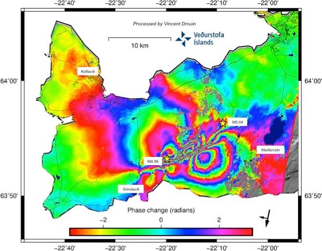
Pretty cool 3D model of the earthquakes from @Vedurstofan - brunnur.vedur.is/vefgogn/skjalf…
After a rather calm evening on the eruption/earthquake front, the activity picked up again overnight with 5 #earthquakes over 3.5. Yesterday had a total of 2,500 earthquakes, making it 18,000 quakes total since the start of the session. The tremor pulse also increased from 5am.

Here is a very good 3D image courtesy of @iceland360vr that shows the #earthquake / #magma area in detail, with all the mountains named and the major earthquakes shown iceland360vr.com/panorama/fagra…
Rescue teams from @Landsbjorg (ICE-SAR) form a critical component of the civil protection system in #Iceland. They are made up of over 3,000+ volunteers that are ready to respond 24/7/365 to natural disasters, missing persons, and rescues.

For those desperate to know if an #eruption has started in #Iceland then this website follows the trend created in Belgium a few years back to check if there was a new government formed...
erkomideldgos.is (hasEruptionStarted)
NEI = No eruption
JÁ = Eruption has started
erkomideldgos.is (hasEruptionStarted)
NEI = No eruption
JÁ = Eruption has started
The Icelandic Red Cross (@raudikrossinn) also plays an important role in the Civil Protection system in #Iceland. They have volunteers who are responsible for establishing shelters, run an information hotline (1717), and provide psychosocial support to those affected.

Here is a link to some good information about the health effects of short-term volcanic SO2 exposure
and recommended actions from @landlaeknir - including a color coding for threat levels landlaeknir.is/servlet/file/s…
and recommended actions from @landlaeknir - including a color coding for threat levels landlaeknir.is/servlet/file/s…

Things have been relatively quiet overnight on the #Reykjanes #earthquake/#eruption front. A few #quakes in the M3-4 range in the past 12 hours, but no clear signs of magma tremors. The location of quakes has become less focused, pointing towards #magma still looking for way up.

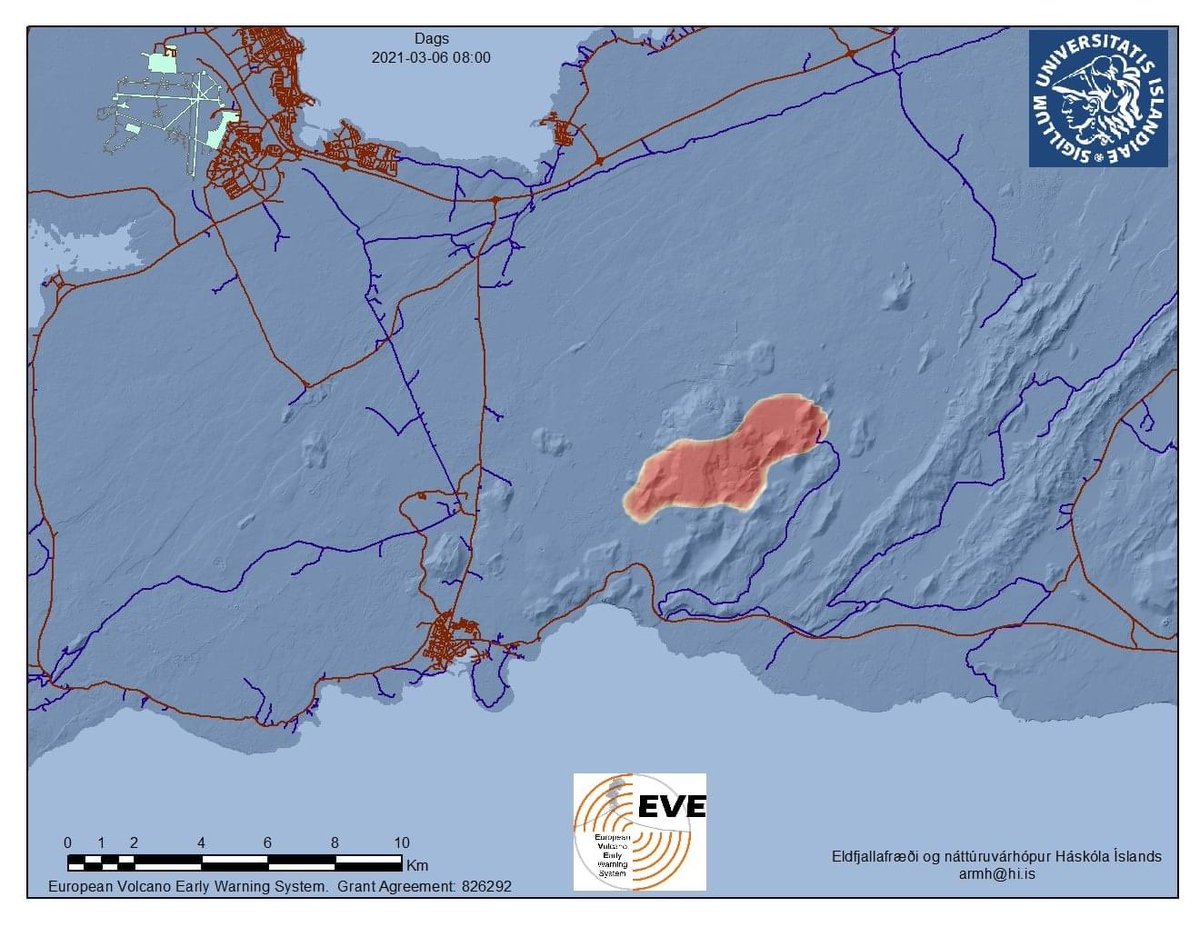
A newly updated potential lava flow map from @uni_iceland showing the potential #eruption areas and associated lava flow projections based on the latest earthquake data.

The #Reykjanes peninsula continues to experience #earthquakes - largest one in the last 24hrs - 4.1M and the latest one 3.6M at 04:11am GMT. Scientists believe the #magma is at a depth of about 2km - moving laterally and not yet finding a way towards the surface. #icerupt

While scientists do not see any signs of immediate #eruption (like they believed they saw Wednesday) - this can change rather quickly if the magma manages to break its way upwards. Time is used to update and revise response plans, including evacuation procedures. #icerupt

Yesterday and overnight, there were electricity issues in #Grindavik and on the southern coast of #Iceland. @Landsnethf - the electrical distribution company - did not blame the #earthquakes for these issues, but it certainly had people worried. #icerupt

There have been 4 periods of volcanic activity on #Reykjanes peninsula since #Iceland was inhabited around 800AD. This map shows the four main periods and the associated #lava flows. Last eruption was in 1240 - which marked the end of a 450 year long eruption period. #icerupt

Scientists believe that the current activity is marking the resumption of activities on the #Reykjanes peninsula & that the various volcanic systems (shown in colors) will cross-interact and become active for decades/centuries to come. #icerupt

An #eruption WILL happen in the #Reykjanes peninsula - WHEN? - The problem with geologists is that when they say "imminent" - it might mean hours/days/weeks/years. To them, an eruption 1000 years ago is a "recent eruption". Hence all Icelanders impatient like Mr. Bean #icerupt
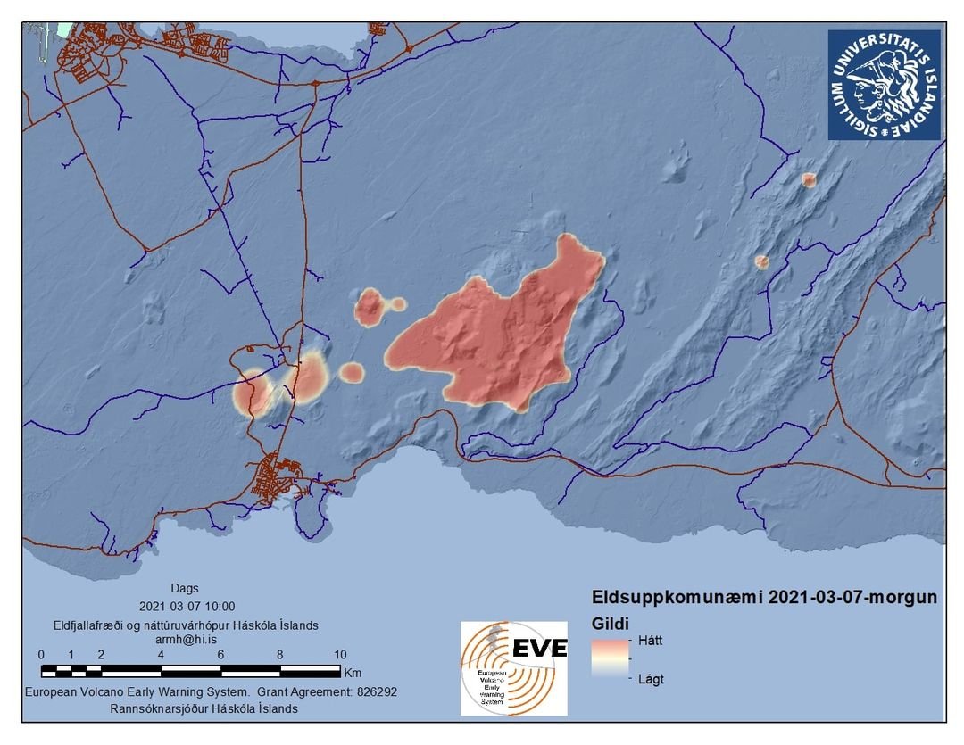
The earthquake activity in the past 24 hours is more focused around Fagradalsfjall and hence the latest potential lava flow models from @uni_iceland much more concentrated in that area #icerupt
Modarate #earthquakes waking people up this morning - 4.1M at 01:40 and a 5.0M at 02:02GMT. No signs of strong #magma movements. #icerupt

So far no sign of magma tremor pulse (eruption tremors) according to @Vedurstofan. After the 5.0M #earthquake an hour ago the distribution of quakes is in a wider area. Some of the 4M+ quakes are close to #Grindavik where people are feeling them strongly.
There are now a few more webcams pointed in the direction of the area affected by #earthquakes on #Reykjanes peninsula:
ruv.is/frett/2021/03/…
visir.is/g/20212080986d…
mbl.is/frettir/innlen…
vegasja.vegagerdin.is/?xmin=315811&y…
#icerupt
ruv.is/frett/2021/03/…
visir.is/g/20212080986d…
mbl.is/frettir/innlen…
vegasja.vegagerdin.is/?xmin=315811&y…
#icerupt
The local @Landsbjorg ICE-SAR rescue teams used the beautiful weather on Saturday to install a new mountain-top VHF repeater to get better radio coverage in the area affected by #earthquakes and potential eruption on the #Reykjanes peninsula #Iceland #Spori #Thorbjorn #icerupt

Around midnight last night, a short tremor pulse (signs of #magma moving upwards) was recorded. This was followed by an episode of relatively strong earthquakes both near Fagradalsfjall and Grindavik. While not a sign of imminent eruption, it does reflect magma movement #icerupt

According to scientists, there are clear signs of #magma moving in under Fagradalsfjall. This creates tension in the North-South fault lines East and West of the area. When enough tension is created, the faults crack and earthquake swarms follow. #icerupt

These periods of earthquakes and then a bit of calm in between can be expected to continue - until tension stops building or an eruption occurs. #icerupt

Scientists at @uni_iceland have developed a new potential lava flow model based on the latest #earthquakes. The area around #Fagradalsfjall still the most likely place for eruption, but the area North of #Grindavik (near @BlueLagoonIS) is also a low potential area. #icerupt
The latest GPS data points to #magma buildup being concentrated in the area between #Fagradalsfjall and #Keilir - which is also the area with most of the #earthquakes. This is good news for people in #Grindavik.
• • •
Missing some Tweet in this thread? You can try to
force a refresh