ANALYSIS: The @Independent Propagandizes Saying Dr. #Fauci "schools @RandPaul for Covid misinformation" Then Senator @RandPaul Takes To @Twitter & Releases Documented Proof That Everything He Claimed The NIH, Fauci, & The Wuhan Lab Were Doing Is True! The @Independent Is WRONG!
CONTD: #Fauci is hiding past work on "super-viruses that jump from animals to humans," Says Senator Dr. @RandPaul. Sen. Paul claims the infectious disease expert "supported @NIH funds for all these labs!" http:// washingtontimes.com/news/2021/may/…
BREAKING: Interstate 40 Is SHUT DOWN At The #MississippiRiver! The #Arkansas Dept Of Transportation (@myARDOT) Says A #Tennessee Inspector Found A “Significant Crack” On The I-40 Bridge Into #Memphis.
East & West Bound CLOSED!
Traffic is rerouted to I-55 as an alternate route.
BREAKING: DAM FAILURE - FLASH FLOOD EMERGENCY!
Mississippi: NE Stone County
A Dam Break Below Lake-A-Way...
Dam Failure On Lake-A-Way Which Drains Into Flint Creek!
Flash Flood Emergency Near HWY 25 & John Willis Rd.
THIS IS A PARTICULARLY DANGEROUS SITUATION.
SEEK HIGHER GROUND!
BREAKING: ***UPDATED***
FLASH FLOOD EMERGENCY HAS BEEN CANCELLED
Flooding along the Flint Creek downstream of Hall Lake Dam near the Lake-A-Way Camp Grounds does not pose a threat. Emergency Management has verified that the dam is still intact.
BREAKING: Reports of up to 7 people shot in #Bryan, Texas some of whom are critically wounded. Additionalt unconfirmed report a @TxDPS trooper was shot in nearby #Iola, #Texas while pursuing suspected shooter. The shooter is still believed to be at large & a man hunt is underway!
CONTD: The shooting reportedly began at Kentmoore Cabinets in a Bryan, Texas industrial park.
CONTD: Bryan County Law Enforcement Are Posting At & Securing Nearby Schools Which Are In Lockdown!
BREAKING: TORNADO EMERGENCY FOR SHELBY COUNTY ALABAMA!
At 136 PM a confirmed large and destructive tornado was located over Indian Springs Village, or near Hoover, moving northeast at 45 mph.
TORNADO EMERGENCY for Hwy 280 Lee Branch. This is a PARTICULARLY DANGEROUS SITUATION.
CONT: HELENA ALABAMA FIRE DEPARTMENT RESPONDING TO COLLAPSED STRUCTURE...
CONT: PELHAM ALABAMA POLICE AND FIRE RESPONDING TO MULTIPLE CALLS FOR ASSISTANCE!
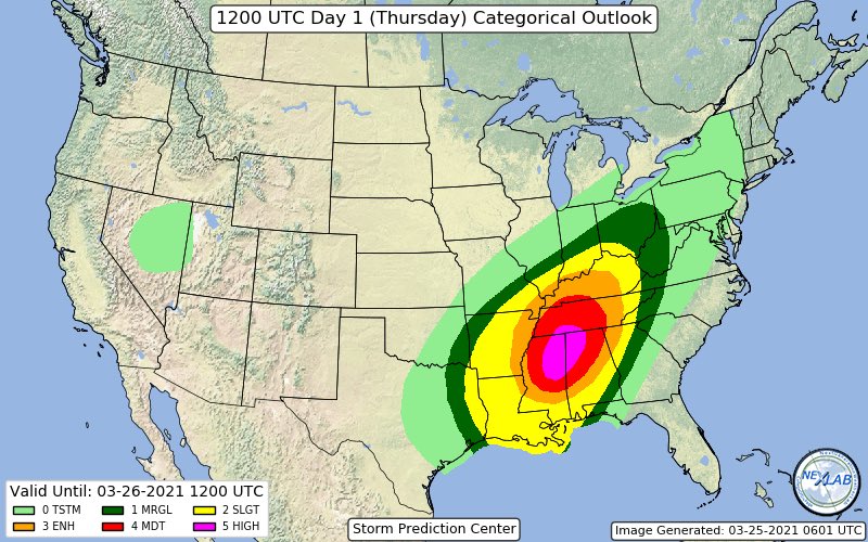
BREAKING: @NWSSPC IS FORECASTING A #TORNADO OUTBREAK IN #MISSISSIPPI#ALABAMA & #TENNESSEE THURSDAY!
SPC Issued "HIGH RISK" Of Severe Weather-"SEVERAL LONG-TRACK STRONG TORNADOES, DESTRUCTIVE WINDS & VERY LARGE HAIL"...This Is A Particulary Dangerous Situation! #mswx#alwx#tnwx
CONT: Compare The Newly Issued "High Risk" Area From The @NWSSPC To Earlier Issued Forecast From @nadocast.
Nadocast Has The Bulls-eye Centered More Over N. #Alabama.
This Is Similar To My Early Forecast For A Number Of Reasons.
Either Way Long-Track Tornadoes Region-Wide!
CONT: The 00Z 3km NAM Model Based "Significant Tornado Parameter"-(STP) Has One Of The Largest "Maxed Out" Areas In Memory.
The Threat Of This Severe Weather Scenario Including The Long-Tracked Strong #Tornado Risk ➡Cannot Be Over-Sold!⬅