Where are the graves of Louisiana’s enslaved people? Our latest story combines historical maps, aerial photos & contemporary satellite images analyzed by @ForensicArchi with compelling field reporting to uncover hidden burial sites.
nytimes.com/video/us/10000…
The maps allow us to go back in time. 19th century maps show cemeteries or other markings; aerial photos, starting in 1940, often show groves of trees in the same locations. Several of these landscape anomalies persist today, marking possible grave sites.
Today, that area is dominated by petrochemical companies, giving it the notorious nickname “cancer alley.” The continued industrialization of the former plantations is putting some of the possible burial sites at risk of destruction.
Here are examples of how some suspected burial sites look now.
Most importantly, @Alexandra_Eaton went to Louisiana to closely look at some of these concealed graves. She interviewed local residents and experts who track some of the cemeteries — and who fight to preserve them.
It’s not only the burial sites that some local residents are worried about. Sharon Lavigne, a local activist, says that a new plant could cause further harm to the predominantly Black community that lives nearby.
The new industrial site has become a flashpoint between the company and some residents.
washingtonpost.com/climate-enviro…
Story, visuals and graphics by @Alexandra_Eaton, Victoria Simpson, Aaron Byrd, @sameenamin, Quincy G. Ledbetter, @therealDahliak @arielle_designs @solanapyne & more
nytimes.com/interactive/20…
More findings and research from @ForensicArchi can be found here:
forensic-architecture.org/investigation/…

• • •

Missing some Tweet in this thread? You can try to force a refresh
 

Keep Current with Christoph Koettl

Christoph Koettl Profile picture

Stay in touch and get notified when new unrolls are available from this author!

Read all threads

This Thread may be Removed Anytime!

PDF

Twitter may remove this content at anytime! Save it as PDF for later use!

Try unrolling a thread yourself!

how to unroll video
  1. Follow @ThreadReaderApp to mention us!

  2. From a Twitter thread mention us with a keyword "unroll"
@threadreaderapp unroll

Practice here first or read more on our help page!

More from @ckoettl

22 Mar
A mysterious tanker. Oil transfers at sea. A retired sailor & a multinational oil trader. What do these four things have in common? They are part of the same convoluted web that helps explain one way #NorthKorea evades sanctions. w/ @RUSI_org & @C4ADS nyti.ms/3vNlYdM
For our newest Visual Investigation, we spent months reviewing ship tracking data and corporate records, satellite imagery and interviewing some of the key players to find out how #NorthKorea sidesteps strict international sanctions.
We focused on a ship called the Diamond 8, the largest foreign oil tanker delivering oil to North Korea. The U.N. Panel of Experts publicly identified the ship in April 2020, and has detailed three trips to North Korea. I found a fourth one. 🛰️📷@maxar nyti.ms/3vNlYdM
Read 20 tweets
9 Dec 20
In our latest story, I break down some of the recent construction at the Natanz nuclear facility, #Iran. Using satellite images, we identify likely new tunnel entrances for an apparent new underground facility.
nytimes.com/2020/12/09/wor…
The article is a snapshot of ongoing developments in Natanz. Here are some of the things we can see as of early December. With analysis by @ArmsControlWonk & graphics by @arielle_designs
The ongoing construction is around 1km south of the main Natanz complex and takes shape five months after an explosion destroyed a centrifuge assembly hall in Natanz. Iran defiantly vowed to rebuild it “in the heart of the mountains.” 🛰️📷 @Maxar Image
Read 8 tweets
20 Sep 20
The Almeda Drive fire left a path of destruction as it tore through an #Oregon valley. Using satellite images, videos and social media posts, our video reconstructs what happened.
nytimes.com/video/us/10000…
The fire destroyed so many homes because it started in a well populated area, after a period of hot and dry weather. And the direction of the strong winds that day perfectly aligned with the valley, pushing it quickly through several towns.
This is one of the first structures that burned in Ashland that day. Many more followed as the fire spread and grew. Ashland police told me they suspect that the fire was man made and that they’ve launched a criminal investigation. 📷 Joe Salamone
Read 9 tweets
7 Aug 20
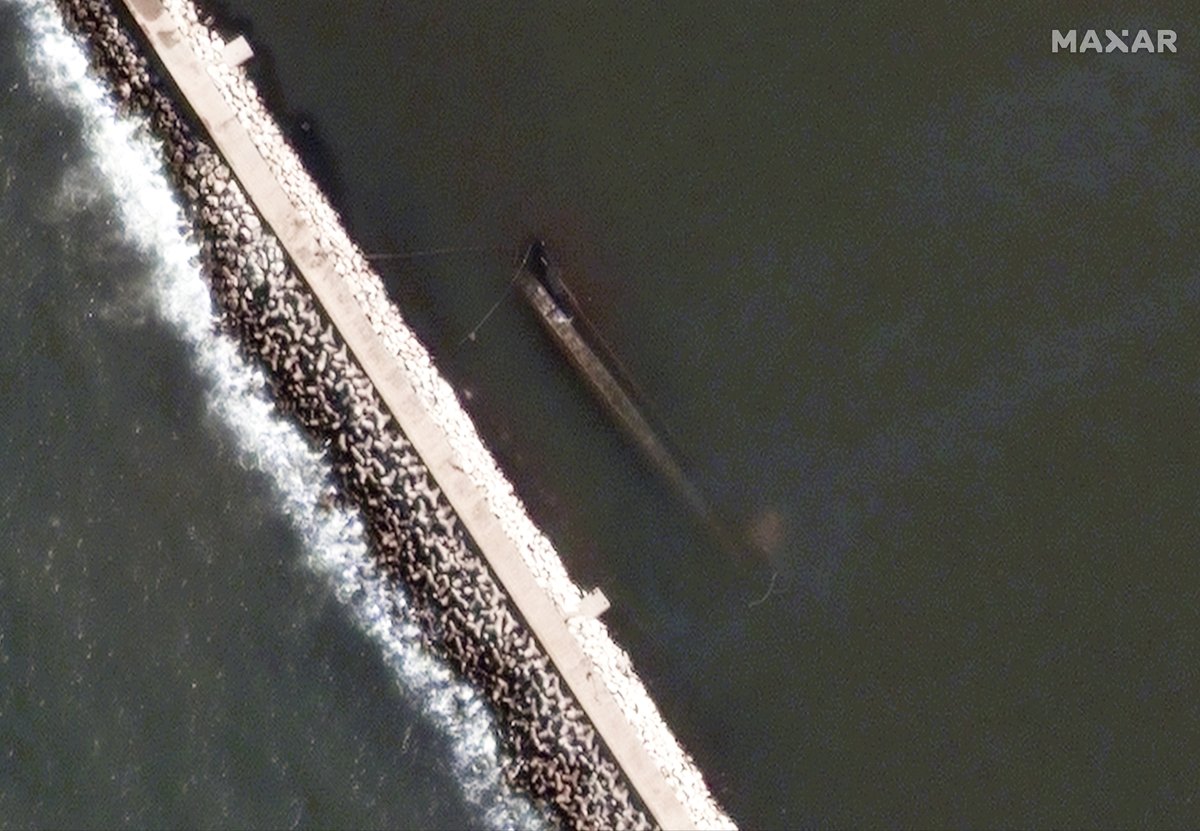
The cargo ship #Rhosus brought 2,750 bags of ammonium nitrate to the port of #Beirut in 2013. I tracked what happened next. The story ends with a massive explosion — and a hidden ship. 🛰️📷 @maxar
nytimes.com/2020/08/07/wor…
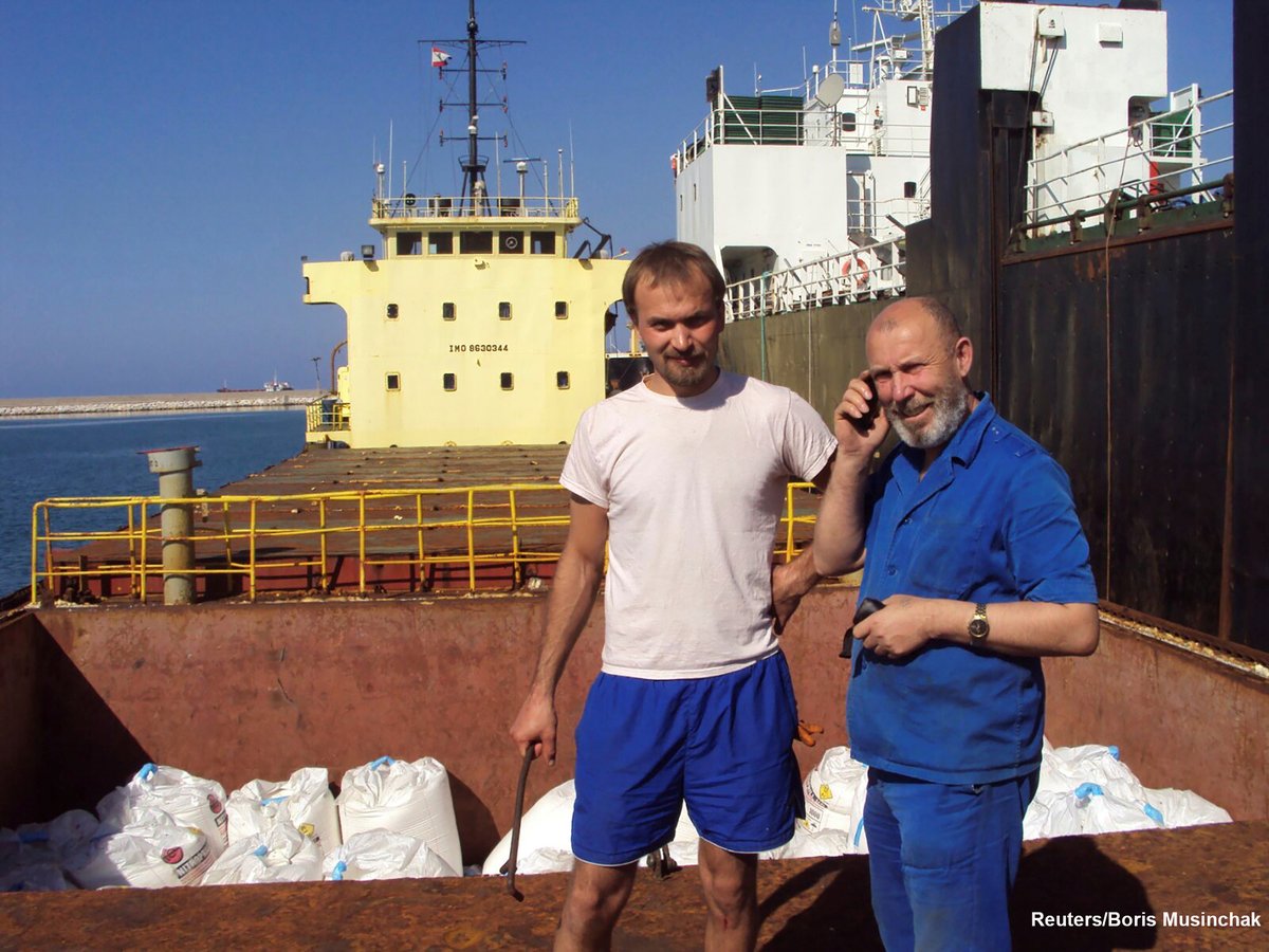
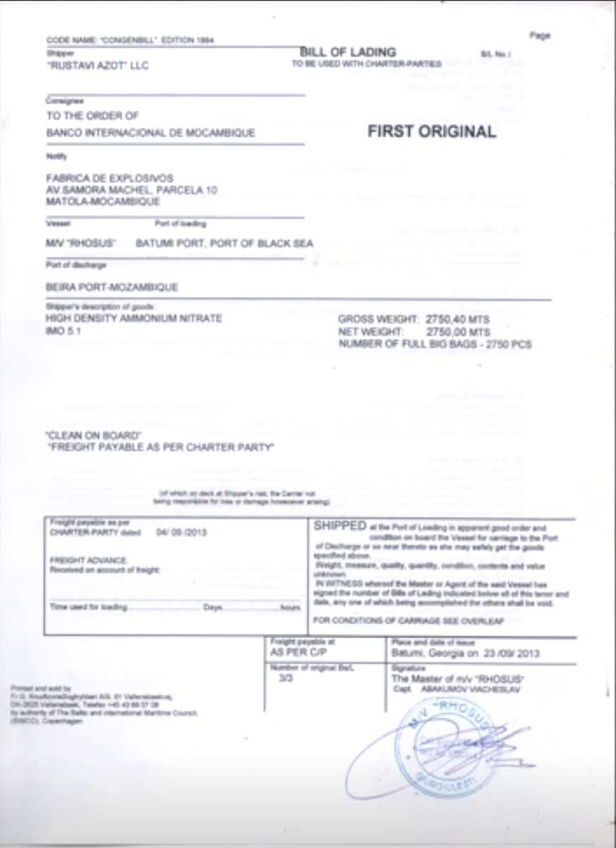
Here's the ship in 2014 at the docks. The captain is in front of ammonium nitrate bags, which match the ones in the warehouse that blew up. Photos from @DimaSadek also show the Georgian company Rustavi Azot, listed as the shipper in documents from 2013
I tracked the ship to two locations in the port. First, at coordinates 33.904934, 35.515357. Earlier image is from September 30, 2014. The second one is from Jan 16, 2015. The open cargo bays and empty hold in the latter indicate that the cargo had been unloaded.
Read 7 tweets
25 Jun 20
Our latest Visual Investigation reconstructs how @PhillyPolice violated its own use-of-force guidelines by using tear gas & pepper spray on a nonviolent group of protesters in #Philadelphia, some of whom were trapped on a highway. Watch what happened.
nytimes.com/video/us/10000…
We went to the site, interviewed witnesses and analyzed dozens of videos. Many thanks to the witnesses Drew, Diamonik, Elias & Callan, who talked to us. Special thanks to Sunny Singh @hate5six — who filmed the whole episode — and to @rohinihaar for her analysis.
.@amnesty recently interviewed a former police officer, Graham Dossett, for its new website: teargas.amnesty.org Here’s an excerpt in which he spells out how not to use tear gas. Amnesty categorized the Philly incident as “unlawful police violence”: amnesty.org/en/latest/news…
Read 11 tweets
15 Aug 19
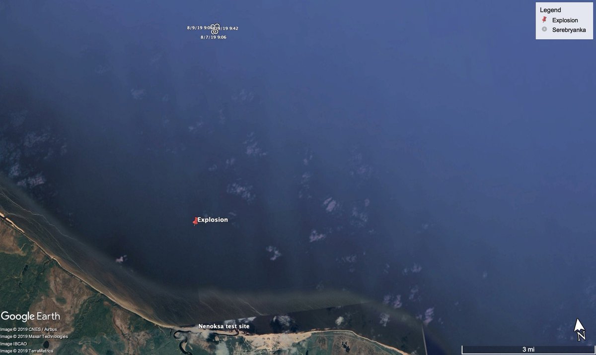
This is a first look at the offshore platform in #Russia, which was likely involved in a nuclear explosion last Thursday. The incident is related to a suspected missile test. The platform is about 2.5 miles from the #Nenoksa missile test range. @Maxar
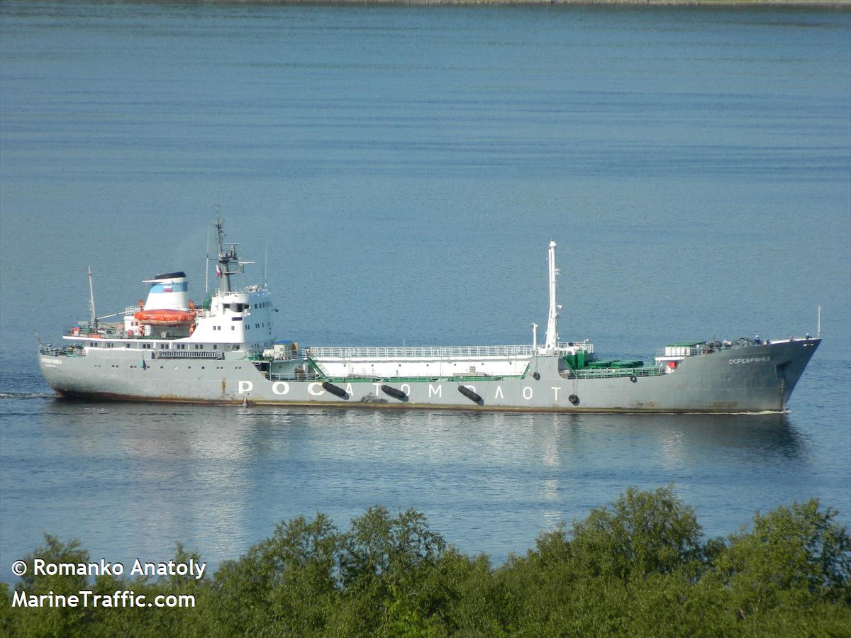
The platform seems mobile & appears to have been moved into place before the explosion —not visible at that location in satellite imagery from July. A nuclear fuel carrier, the Serebryanka, was moved into place around the same time. Image & Data via @MarineTraffic
@MarineTraffic The presence of the Serebryanka is relevant and might offer clues of what happened. This very ship was previously used in recovery effort for a crashed SSC-X-9 — a prototype of a nuclear-propelled cruise missile — according to @ArmsControlWonk
Read 8 tweets

Did Thread Reader help you today?

Support us! We are indie developers!


This site is made by just two indie developers on a laptop doing marketing, support and development! Read more about the story.

Become a Premium Member ($3/month or $30/year) and get exclusive features!

Become Premium

Too expensive? Make a small donation by buying us coffee ($5) or help with server cost ($10)

Donate via Paypal Become our Patreon

Thank you for your support!

Follow Us on Twitter!

:(