This thread is about Typhoon #INFA, a storm the likes of which the world has never seen before. Enduring, unpredictable, astonishingly wet, massive, slow moving, and never alone.
And 13 days after designation as a storm, #INFA is far from finished in its journey of destruction
And 13 days after designation as a storm, #INFA is far from finished in its journey of destruction


My coverage of #INFA began on 14th July after it had formed into a visible and formidable storm, albeit not yet a Typhoon. But by then weather models already showed it was a significant threat.
Not simply as a storm but as a broader weather pattern.
Not simply as a storm but as a broader weather pattern.
https://twitter.com/althecat/status/1415211467390033921?s=20
The area in which the storm was expected to form showed up in the models earlier. Here we see it on the 10th of July in the GFS MLSP forecast. But it was probably there even earlier.
https://twitter.com/althecat/status/1413935267640193026?s=20
By July18th #INFA #Fabian was a big storm. This was the day after the enormity of the German Belgium flooding event had become clear and I was wondering what might come next.
https://twitter.com/althecat/status/1416724731290603522
#INFA was named that evening. And although already huge wasn't yet a typhoon.
https://twitter.com/althecat/status/1416829308472119296
And In-fa was not alone either. Another tropical storm #Cempaka was nearby, and it was the interaction between #INFA and #Cempaka over the following days that made In-fa what it became. Here you see the models prediction of what was about to happen.
https://twitter.com/althecat/status/1416833624993902600
But that is not what happened. What did happen took longer and #Cempaka - which became a rare midget typhoon shortly after this - proved to be a more resilient storm than expected.
And by July 18 models also showed #Nepartak heading to the Olympics.
And by July 18 models also showed #Nepartak heading to the Olympics.
https://twitter.com/althecat/status/1416839755820568584?s=20
By July 19th this predicted interaction became apparent. #INFA started carving off #Cempaka's outflow and building a huge gyre, which would eventually give birth to #Nepartak, and which is currently nurturing a 2nd Olympics bound child storm.
https://twitter.com/althecat/status/1417050273848172544?s=20
The official JTWC portraits of #Cempaka and #Infa from 19th July show how tiny and nuggety #Cempaka is compared to her big sister.
https://twitter.com/althecat/status/1417233662362464259?s=20
Here we see the pair of storm the following day and #Cempaka had by then strengthened to typhoon strength. With the benefit of hindsight it appears that #INFA's influence held her back and she remained stationary for a long time lashing HK.
https://twitter.com/althecat/status/1417450636896047104?s=20
Here are the official forecasts from the following day July 21st. #Infa was forecast to make landfall on the 25th of July by then, which turned out to be not far from right, both in location and time.
https://twitter.com/althecat/status/1417819766019039234?s=20
And here are some more high-resolution portraits of the #Cempaka and #Infa found on @NASA's amazing Worldview service.
By now #Cempaka was being seriously destructive, but #INFA was still out in the Philippines Sea being tracked as #FabianPH.
By now #Cempaka was being seriously destructive, but #INFA was still out in the Philippines Sea being tracked as #FabianPH.
https://twitter.com/althecat/status/1417821998571479042?s=20
And by now #INFA's tail gyre was getting huge, shown here as pictured in @zoom_earth and #Meteoblue live data satellite imagery.

When measure with her gyre, #INFA was now the size of Australia, #Nepartak was about to form, and #Infa was still a few days from landfall.
https://twitter.com/althecat/status/1417827215631437827?s=20


By then I was closely watching what would happen after #INFA made landfall and did not at all like the look of what I could see. #INFA's tail appeared to be sticky, unlikely to disperse to the east and was forecast to continue to batter Japan.
https://twitter.com/althecat/status/1417857846612570112?s=20
The following day my update was rather gloomy. The full thread is here.
https://twitter.com/althecat/status/1418025053187411969?s=20
But what I was particularly worried about was this GFS PWAT forecast. This turned out to be wrong. Soon after GFS aligned with the consensus view on a Shanghai landfall, but the actual landfall currently underway is, I suspect, worse than either scenario.
https://twitter.com/althecat/status/1418059222550470657?s=20
On July 23rd the long predicted #3rdStorm was designated by the JTWC, and soon after named #Nepartak, although it took a while for her to become visible as a storm.
https://twitter.com/althecat/status/1418614709448757248?s=20
This animation is I think the only one I have of all three storms simultaneously live under JTWC monitoring.
https://twitter.com/althecat/status/1418698120020516869?s=20
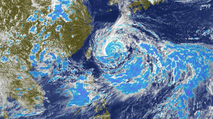
Over the previous 3 days INFA slowed and grew larger - and during this period she was remotely controlling the weather over a huge area from Vietnam to Japan and the Phillipines to Zhengzhou City, Henan province.

Here's the thread from July 24th, which includes this picture from @NASA of #INFA on the morning of the 24th. providing a glimpse of the scale.
https://twitter.com/althecat/status/1418699233906024455?s=20

This animation shows #INFA over 24 hours from midnight on the 24th to midnight on the 25th.
And that is when the really heavy widespread rain over mainland China began.
By then #INFA was technically not a particularly strong cyclone. Cat 2 in Hurricane terms. And she [Note: In-fa is a male and female name] didn't have a big coherent eye as this sequence of photos shows.
This is because her wind field was sucking in huge quantities of dry air.
This is because her wind field was sucking in huge quantities of dry air.


Here's another view of #INFA as her eye made landfall just south of Shanghai on the morning of 25 July.
https://twitter.com/althecat/status/1419186189500829698?s=20
And #Nepartak at around the same time.
https://twitter.com/althecat/status/1419385957170696192?s=20
And here we see the beginning of why #INFA is truly different. from any great cyclone that I have seen before. She did not break up once over the land. This shows her first 12 hours after landfall.
https://twitter.com/althecat/status/1419731587294535684?s=20
My thread from the 26th didn't focus on #INFA in any detail, but instead looked at a broader picture. On the 24th and 25th of July there were massive floods all over the planet, so I decided to take a broader view but starting with #INFA and #Nepartak.
https://twitter.com/althecat/status/1419730944274092039?s=20
Here is the forecast from the 26th, which shows a new 3rd storm, #INFA's second child forming.
https://twitter.com/althecat/status/1419733643510099975?s=20
Here's the next 24 hours, to midnight on the 26th. and as you can see #INFA didn't move very far. During this period the rainfall data feed to @zoom_earth appears to have been turned off.
And the next 24 hours after that, to midnight on the 27th. by the end of this sequence most of INFA has been over land for 72 hours, and yet it still looks like a fully functional super storm.
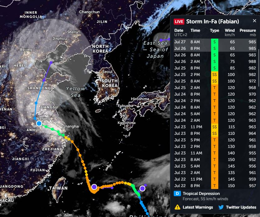
This graphic allows you to see what the official recordings of strength look like through this period of time. (Times shown here are my local time UTC+2 so you need to add 4 hours to get to local time - I think :).
And then here's the latest 24 hours till this evening. #INFA is now moving faster, and that seems to have resulted in heavier rain. And the yellow tail of rain you see there over Jiangsu looks eerily similar, but a lot worse, to what occurred in Henan province a week ago.
Meanwhile now we also have another new #3rdStorm in the area, it was designated by JTWC yesterday, and hasn't yet got a name. And it is ultimately heading towards southern Japan according to the models.
https://twitter.com/althecat/status/1420036822105796613?s=20
For now it's backtracking along the path that #INFA took five days ago.
And if you like the imagery you see in this thread, you can observe the rest of this drama live at @zoom_earth here >> zoom.earth/storms/95w-202…
And if you like the imagery you see in this thread, you can observe the rest of this drama live at @zoom_earth here >> zoom.earth/storms/95w-202…

And in the meantime I will be sending my thoughts and prayers to the 100s of millions of people who either have been under, are currently under, or are in the path ahead of #INFA over the next two days.
Stay safe China.
/ENDS
Stay safe China.
/ENDS
@ThreadreaderApp unroll.
• • •
Missing some Tweet in this thread? You can try to
force a refresh