Hurricane Ida traveled over very warm Gulf of Mexico, rapidly intensified & nearly became Category 5 prior to landfall in Louisiana.
Al Roker said Gulf waters were 3° to 5°F above average due to climate change & directly caused Ida's intensity.
Al Roker said Gulf waters were 3° to 5°F above average due to climate change & directly caused Ida's intensity.
https://twitter.com/LisPower1/status/1432399740373721091?s=20
I saw similar reporting that Gulf of Mexico sea-surface temperatures were ridiculously warm, 85°-90°F, and that's certainly true. But, the Gulf of Mexico on average is always that temperature in August (unless a previous hurricane mixes up cooler water from below).
The entire Gulf of Mexico ocean surface can support a major hurricane if it is given enough time over the ocean to intensify, and other wind shear, humidity factors are favorable. Obviously, the long history of Gulf hurricanes is a testament to what nature hath wrought.
So, what was special about late-August 2021? I was certainly curious b/c I did not see any data analysis in any media reporting, just expert testimony.
The ocean surface (SST) was at least 30°C for the "hurricane" and rapid intensification phase of Ida right up to the coast.

The ocean surface (SST) was at least 30°C for the "hurricane" and rapid intensification phase of Ida right up to the coast.


Cooling effects of the previous Hurricane Grace are seen in the anomaly map (blue colors), while warmer than normal shelf waters extended from the Texas Bight to mouth of the Mississippi.
Longer 28-day average shows generally warmer than normal (~0.2°C) than previous 30-years.

Longer 28-day average shows generally warmer than normal (~0.2°C) than previous 30-years.


Next, I took the Gulf of Mexico as a domain & used last 40-years of SST data (satellite retrieval) from OISSTv2.1 and created this nice matrix:
August 2021 Gulf SST ranged from 29.8° to 30.1°C, and you can follow downward to see previous years e.g.
August 1997 29.5° to 30.5°C
August 2021 Gulf SST ranged from 29.8° to 30.1°C, and you can follow downward to see previous years e.g.
August 1997 29.5° to 30.5°C

The average of this entire matrix (1982-2021) ranges from 29.6°C to 29.7°C from August 1-31, which means Gulf of Mexico temperatures overall vary little on average during the entire month (climatology).
August 2021 temperatures = 29.9°C or 0.3°C above last 40-years average.
August 2021 temperatures = 29.9°C or 0.3°C above last 40-years average.
I've mentioned over the past days that the shallower shelf waters along Louisiana coastline are well mixed and very warm from surface to seafloor. A hurricane cannot mix up cooler waters from below if there isn't any.
Hurricane forecasters of yesteryear observed almost all Gulf landfalling hurricanes weakened, and dramatically so, upon nearing the coast, likely due to winds in outer circulation upwelling cooler water.
That went out the window with Harvey, Laura, Michael & now Ida.
That went out the window with Harvey, Laura, Michael & now Ida.
The Rapid Intensification up until landfall (and interrupted eyewall replacement cycle) likely benefitted from the warm shelf waters at the surface, and any mixing would have been limited to Ida's fast forward motion. But that's just speculation. 🌀
The proximate boost to Hurricane Ida's intensity was the deep warm reservoir of ocean heat within the Gulf of Mexico Loop Current.
But until Ida worked out the organization kinks, it looked ragged and slowly intensified.
Then, it went over the Loop Current jet fuel ⛽
But until Ida worked out the organization kinks, it looked ragged and slowly intensified.
Then, it went over the Loop Current jet fuel ⛽

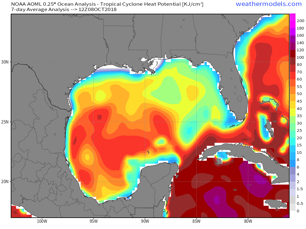
But an extreme ocean heat potential anomaly isn't required for a Category 5. Check out Hurricane Michael's heat potential from October 2018 ... maybe 1/4 magnitude compared to Ida's loop current. 

• • •
Missing some Tweet in this thread? You can try to
force a refresh


