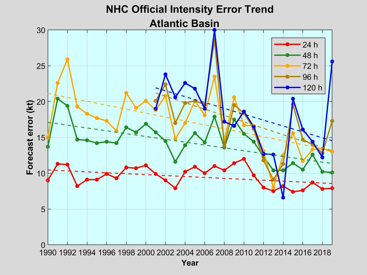
While we have a forecast track cone based upon historical errors (170 miles at 4 days) plopped on the map, there isn't a similar intensity uncertainty graphic that conveys information for intensity -- about 15 knots. Example would be 100-115 knots or Cat 3 or Cat 4.
Error trend:
The chart of average intensity errors shows last 30 years lumping all forecasts together. You could filter further by region, month, initial intensity, etc.
Intensity skill improvement has leveled off in past 10 years, or so.
Now it's important to note that NHC is not forecasting a range of results. They aren't putting out forecasts saying Ida could be 105 to 120 knots, but based upon previous errors, it's implied that there is inherent uncertainty.
And, it would be a big problem if NHC started out their forecast high at Cat 5, saying Ida has the maximum potential of 160 mph, and then issue a later forecast saying never mind. Thus, it's a balancing act.
I think some sort of graphic or messaging needs to be created that conveys the one Saffir-Simpson category historical intensity error. Perhaps a color coded chart.
I know this treads into probabilistic forecasting but maybe it's time for it. 🌀
• • •
Missing some Tweet in this thread? You can try to
force a refresh
@Mailchimp In the 1860s, Ponce De Leon Springs are popular attraction for Atlanta residents. Later in 1903, the site is turned into the "Coney Island of Atlanta" -- an amusement park.
@Mailchimp In 1907, the Ponce de Leon lake is drained to make way for a minor league baseball park, where the Atlanta Crackers play for decades, until moving to Atlanta Stadium in 1965.
Turns out the "extreme rainfall" records being reported by NY Times might be neglecting paper records in existence prior especially prior to the 1940s.
"The heavy downpour ... let loose upon the city and which probably broke all records for a similar period ... flooded subways, railroad tunnels, basements and streets ..."
"...bolts of lighting played a tattoo upon church steeples" (?)
July 28, 1913 RECORD RAINFALL FLOODS THE CITY
Sewer overflow swamps hotels
BACK GUSH FROM DRAINS 😲
Same infrastructure as today,. not built to withstand weather from 108-years ago 👇
Property Owners to Demand Relief from Inadequate Sewers
There is a popular narrative being amplified by media outlets that recent extreme weather events are unpredictable, came out of no where, or were unexpected.
Actually, it's failed leadership to be ignorant of extreme weather & climate threats, and then use that as an excuse!
Former NYC Mayor Bloomberg was a disaster when it came to preparing for extreme weather especially blizzards.
This is in direct contrast to Mayor de Blasio who proactively got the plows running for his first major snowstorm in Jan 2014.
I saw similar reporting that Gulf of Mexico sea-surface temperatures were ridiculously warm, 85°-90°F, and that's certainly true. But, the Gulf of Mexico on average is always that temperature in August (unless a previous hurricane mixes up cooler water from below).
The entire Gulf of Mexico ocean surface can support a major hurricane if it is given enough time over the ocean to intensify, and other wind shear, humidity factors are favorable. Obviously, the long history of Gulf hurricanes is a testament to what nature hath wrought.
Just overheard "eyeball replacement cycle" 🧐
The intensity has thankfully leveled off at 130-knots - top end Category 4. #HurricaneIda continues a recent trend of Gulf of Mexico storms that do not weaken approaching landfall instead blowing up to max intensity.
The Gulf of Mexico is always warm enough to develop a major hurricane in August, with warm eddies spinning and looping providing extra ocean heat content. But a major recent difference is top-to-bottom extreme warmth of shallower shelf waters along TX and LA coasts.
30°C+
There's the Gulf of Mexico "loop current" strategically located along the track of Hurricane Ida.
Random chance that Ida crossed it? Or some chicken and the egg here?