As we're in peak Hurricane Season and the tropical Atlantic remains active, here's a quick reminder to make sure you're tuned into reliable sources (first and foremost @NHC_Atlantic) and tuned out of the cacophony of misinformation.
Here's some BS I've been asked about today:
@NHC_Atlantic Both of these outlets are well-known purveyors of misinformation about tropical cyclones. If you're following them, I suggest the unfollow button.
If friends/family ask you about their posts, I'd make the same suggestion.
@NHC_Atlantic Remember:
-ONLY the NHC makes determinations about what category a storm is, and anyone claiming to do so is leading you astray.
-NO long range (7-10day+) deterministic model forecast is worth posting or getting concerned about.
@NHC_Atlantic If you're looking for good, reliable info about tropical threats in the Atlantic, here are a couple of good lists curated by well-respected meteorologists to get you started.
@NHC_Atlantic By far the most controversial part of this post has been calling out Force Thirteen, so for all those unaware, they posted what appears to be an official NHC forecast map for a storm last year but instead is their own forecast dressed up in official-looking colors.
I’m never going to be perfect but I try very hard to respond to and improve from criticism.
Neither outlet I mentioned in my earlier tweet has ever made even cursory gestures in that direction, hence the rather harsh approach in dealing with them.
I definitely don’t want my initial tweet to be interpreted as “HS kids in their parents basement are the problem” as someone who has done (and is still doing! And will still be doing until May!) a lot of tweeting without the requisite degrees.
Winds still steady at 105mph as the pressure falls to 964mb.
Satellite presentation continues to improve, but we'll have to wait until the next recon plane arrives in a few hours to see whether that's translating to stronger winds.
Winds haven't come up as much as anticipated today, due largely to some lingering chaos in the inner core after Cuba.
But the storm has picked up tons of energy, dropping its central pressure by >20mb and pushing hurricane force winds dozens of miles from the center.
All environmental and satellite indicators continue to point towards rapid intensification tonight.
That's what folks should expect and plan on.
Regardless of what max winds a few spots see in the eyewall, surge and rain will be catastrophic.
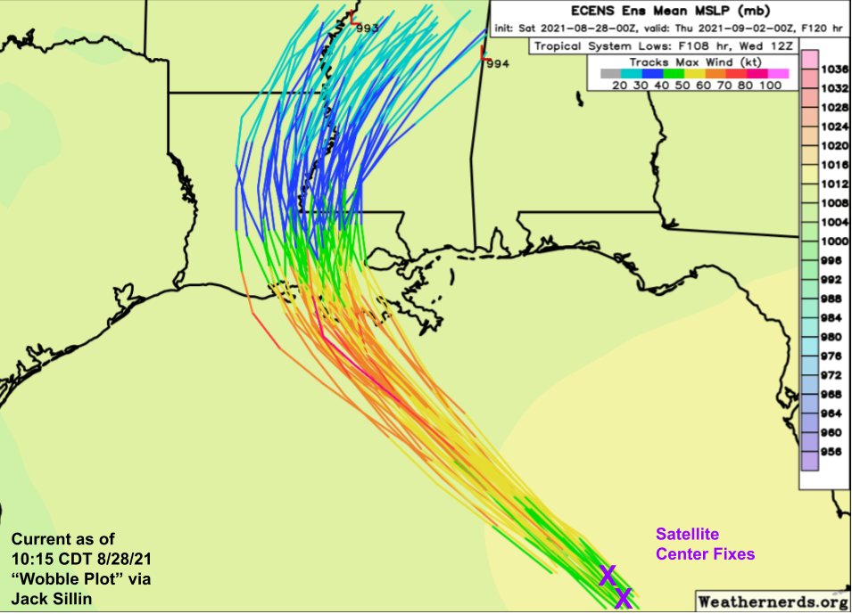
During Laura last year, I cobbled together a little visual to monitor trends in the storm's track and distinguish steady trends from short-term wobbles.
Well the #wobbleplot is back for #Ida. Satellite fixes suggest the storm remains towards the eastern edge of track guidance.
Checking in on the #WobblePlot roughly an hour later, #Ida is still following the NE side of the ensemble guidance envelope.
I've penciled in the mental adjustment to ensemble guidance I've been making in light of these trends.
The core may get rather close to New Orleans.
12:05 PM 8-28-21 #WobblePlot update shows plenty of wobbling, last hour it was to the west this hour to the north.
But the general trend remains pretty steady. #Ida is still tracking along the eastern edge of forecast model guidance.
IR satellite imagery this morning shows twin "vortical hot towers" (incredibly intense thunderstorms) pinwheeling around #Ida's center.
This is a signal that the storm has fully patched whatever damage Cuba did to its core and is once again rapidly intensifying.
Hurricane Hunters are flying into the storm this morning to provide more detailed information on its structure and intensity.
The first @NOAA_HurrHunter plane is now approaching the center from the northwest.
@NOAA_HurrHunter After hints of some tilting with height last night, @NOAA_HurrHunter finds #Ida's center nestled right between these two big convective bursts.
In this environment, it shouldn't take long for the hot towers to merge/expand into a mature eyewall.