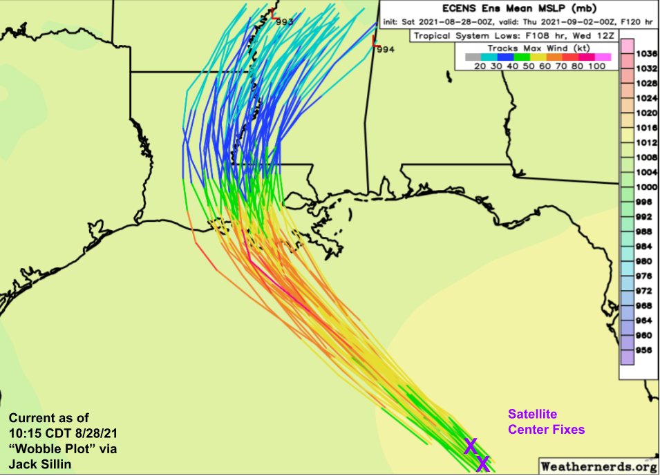
During Laura last year, I cobbled together a little visual to monitor trends in the storm's track and distinguish steady trends from short-term wobbles.
Well the #wobbleplot is back for #Ida. Satellite fixes suggest the storm remains towards the eastern edge of track guidance.
Well the #wobbleplot is back for #Ida. Satellite fixes suggest the storm remains towards the eastern edge of track guidance.

Checking in on the #WobblePlot roughly an hour later, #Ida is still following the NE side of the ensemble guidance envelope.
I've penciled in the mental adjustment to ensemble guidance I've been making in light of these trends.
The core may get rather close to New Orleans.
I've penciled in the mental adjustment to ensemble guidance I've been making in light of these trends.
The core may get rather close to New Orleans.

12:05 PM 8-28-21 #WobblePlot update shows plenty of wobbling, last hour it was to the west this hour to the north.
But the general trend remains pretty steady. #Ida is still tracking along the eastern edge of forecast model guidance.
But the general trend remains pretty steady. #Ida is still tracking along the eastern edge of forecast model guidance.

1:05 PM CDT 8-28-21 #WobblePlot:
#Ida is wobbling a bit between our hourly check-ins, but is holding pretty steady overall. Wandering closer to the E edge of the guidance envelope.
This might shave off a few hrs it could have had over the Gulf, but puts the core closer to NOLA.
#Ida is wobbling a bit between our hourly check-ins, but is holding pretty steady overall. Wandering closer to the E edge of the guidance envelope.
This might shave off a few hrs it could have had over the Gulf, but puts the core closer to NOLA.

2:05 CDT 8-28-21 #WobblePlot:
#Ida has continued to wander farther right of EPS guidance and other track forecasts.
The system should swing a bit to the left this eve as it gets closer to a ridge over NC, but I think it's time to seriously consider eyewall impacts in #NOLA.
#Ida has continued to wander farther right of EPS guidance and other track forecasts.
The system should swing a bit to the left this eve as it gets closer to a ridge over NC, but I think it's time to seriously consider eyewall impacts in #NOLA.

4:05 CDT 8-28-21 #WobblePlot:
#Ida holding steady to the right of almost all forecast guidance, even our mentally-adjusted guidance from earlier today.
This seems to be due to changes in how Hurricane Nora is influencing an upper-level low SE of Texas
#Ida holding steady to the right of almost all forecast guidance, even our mentally-adjusted guidance from earlier today.
This seems to be due to changes in how Hurricane Nora is influencing an upper-level low SE of Texas
https://twitter.com/btangyWx/status/1431719819930386432

• • •
Missing some Tweet in this thread? You can try to
force a refresh


