An intro to earthquake prediction 🧵🧵

Individual earthquakes can’t be usefully predicted. It’s not because they’re mystical or magical. Earthquakes obey very simple physics. The issue is that earthquakes occur deep underground.
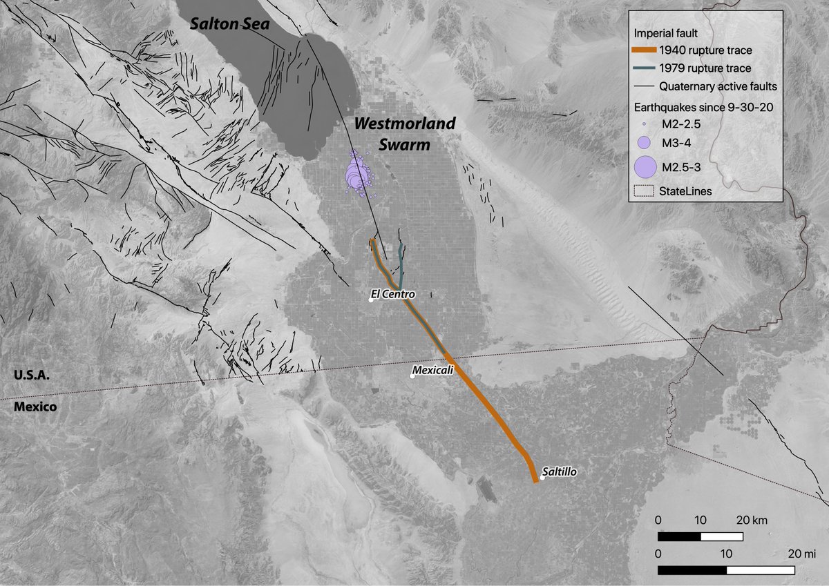
In California, earthquakes typically rupture faults at depths of ~10 mi (~15 km). We have no eyes on the fault at depth: can’t see what materials are in the fault, where they’re lubricated by fluids, how close any point is to failure, or how large an area might fail.
If you can’t see the fault at depth, you can’t directly predict what the fault will do. Instead some researchers try to correlate large quakes with other things like having small quakes – or maybe not having small quakes? It’s not clear that there is any predictive power here.
How can you tell if a prediction is legitimate? There’s a scientific body for that!
National Earthquake Prediction Evaluation Council ow.ly/uXc250GrIOp
If there is a prediction that passes muster, you’ll hear about it here not from something your cousin sent you on Facebook
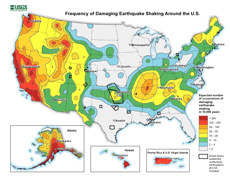
We can’t predict when & where a specific earthquake will happen. But we can see how much total strain is being accumulated & so we can forecast how much shaking you will eventually experience in 1 or more quakes. Check out the National Seismic Hazard Map! ow.ly/BYAZ50GrIY5 Map of seismic hazard in the United States
Also, we have aftershock forecasting, which is a stats model based on a catalogue of thousands of earthquakes. So, we formulate the forecast based on math and history. Aftershock forecasts are released when an eq is large enough (M5.0+) in the USA. More: earthquake.usgs.gov/data/oaf/overv…

• • •

Missing some Tweet in this thread? You can try to force a refresh
 

Keep Current with USGS Earthquakes

USGS Earthquakes Profile picture

Stay in touch and get notified when new unrolls are available from this author!

Read all threads

This Thread may be Removed Anytime!

PDF

Twitter may remove this content at anytime! Save it as PDF for later use!

Try unrolling a thread yourself!

how to unroll video
  1. Follow @ThreadReaderApp to mention us!

  2. From a Twitter thread mention us with a keyword "unroll"
@threadreaderapp unroll

Practice here first or read more on our help page!

More from @USGS_Quakes

1 Sep
**New publication alert**
What could happen to communication networks if a large #earthquake happened in the SF Bay Area, along the Hayward fault? 📞📱☎️📳
The new #HayWiredScenario chapter on telecommunications & ICT asks “what if” & explains why we should #TextNotTalk Map depicting SCENARIO distribution of shaking severity in a
Using proxies including power shutoffs, wildfires, & other earthquakes to model what happens to #telecom in a #HayWiredScenario, they found vulnerabilities in power service, cell sites on buildings and poles, and data lines crossing the fault surface rupture. Map of the San Francisco Bay region, California, showing fib
Contributing to the issue are multiple competitive service providers in a largely unregulated industry, convergence of analog and digital systems, layers of hardware and software functionality, dependence on electric power, and the rapid evolution of technology. Photo showing co-located electrical and telecom infrastructuThese photos show repair dependence between telecommunicatio
Read 9 tweets
9 Jul
Yesterday afternoon, just before 4 pm local time, a M6.0 earthquake occurred at the California-Nevada border. Let’s dive deeper into some of the regional geology on this edition of #FaultFriday.
East of the San Andreas fault, the plate boundary doesn’t stop moving. Even though ~70% of the relative motion of the Pacific-North American plates occurs within the San Andreas fault system, that leaves ~30% to be accommodated elsewhere.
Moving east from the San Andreas fault from ~San Francisco, more plate motion is accommodated at the eastern rangefront of the Sierra Nevada. If you’ve ever wondered why the Sierra look even more impressive from the east than the west, enter: active tectonics.
Read 13 tweets
9 Jul
Update on the M 6.0 #earthquake that occurred at 3:29 pm Pacific Time July 8, in Antelope Valley, California, near the Nevada border. #califearthquake You can find up-to-date details about the earthquake here: earthquake.usgs.gov/earthquakes/ev…
Shaking of intensities up to VII was reported nearest the epicenter. The quake was felt all the way to the Pacific Coast and throughout CA’s Central Valley as well as strongly in Reno and Carson City.
Did You Feel It? Report here:
earthquake.usgs.gov/earthquakes/ev…
Our @USGS_ShakeAlert earthquake early warning system sent out some ShakeAlert-powered alerts through phone apps and @Google @Android. Check out earthquake.usgs.gov/earthquakes/ev… for more information about ShakeAlert’s performance.
Read 5 tweets
6 Jul
An M5.2 earthquake occurred 12 km (7.5 mi) NNW of Kukuihaele, Hawaii yesterday at 1:34 PM local time. So far >1,300 people have reported feeling shaking. If you felt this quake (or not!), click the link below to tell us about your experience. For more on EQs in Hawaii, see 🧵👇.
Thousands of earthquakes occur every year in the State of Hawaii most of which are small & caused by eruptive processes w/in the active volcanoes on & around the Island of Hawaii, especially in the southern districts where the Kilauea, Mauna Loa & Loihi volcanoes are most active. Image
Other EQs can occur in Hawaii along tectonic faults in the crust & upper mantle & can be related to deep structural adjustments from the weight of the lava-built islands on Earth's underlying crust. This is the most common source of damaging EQs north of the Island of Hawaii. Image
Read 7 tweets
4 Mar
Two large earthquakes have occurred beneath the southwest Pacific today. The earlier M7.3 was strongly felt across much of New Zealand. The more recent M7.4 occurred ~4 hr later, ~900 km away. Given the large distance between them, the events are probably not directly related. 🧵 map showing earthquake epicenters for March 5 in the south P
The @USGS-determined focal mechanism and origin location for the earlier M7.3 near New Zealand suggest that the earthquake resulted from complex faulting within the subducting Pacific Plate. earthquake.usgs.gov/earthquakes/ev…
@USGS The M7.4 much farther north along the Kermadec Trench has a focal mechanism and origin depth consistent with slip along the subduction interface between the Pacific and Australia Plates. earthquake.usgs.gov/earthquakes/ev…
Read 5 tweets
2 Oct 20
Yes, swarms aside, it is still Friday, and on this channel, that means #FaultFriday. To learn more about the area around the Westmorland swarm, let’s look at the Imperial fault of southern California today.
The Imperial fault is a right-lateral strike-slip fault (ow.ly/gKEq50BIfDq) that runs south of the Salton Sea, across the US-Mexico border, and into Mexico. The Imperial fault had two significant earthquakes in the 20th century, a M6.9 in 1940 and a M6.5 in 1979. Map showing Imperial fault and Westmorland Swarm in southern
Before the 1940 El Centro event, this fault probably did not have an earthquake in the previous 300 years. Geologists can literally uncover the history of past earthquakes along a fault by digging a shallow trench across a fault and observing and dating the offset layers.
Read 6 tweets

Did Thread Reader help you today?

Support us! We are indie developers!


This site is made by just two indie developers on a laptop doing marketing, support and development! Read more about the story.

Become a Premium Member ($3/month or $30/year) and get exclusive features!

Become Premium

Too expensive? Make a small donation by buying us coffee ($5) or help with server cost ($10)

Donate via Paypal Become our Patreon

Thank you for your support!

Follow Us on Twitter!

:(