The weather in the middle east is already pretty weird - but it is about to get a lot weirder.
Simulations show a spectacular monsoon driven burst of water and energy pulsing over the Arabian Peninsula, bringing rain to the entire desert land mass over the next three weeks.
Simulations show a spectacular monsoon driven burst of water and energy pulsing over the Arabian Peninsula, bringing rain to the entire desert land mass over the next three weeks.
This thread's coverage fits into our #ExtremeWeather #ClimateChangeNow #DesertRain #ArabianStorms and #WestAfricanMonsoonBurst baskets.
The animations above and below are both from this afternoon. And they show the developing weather patterns which will bring this event.
The animations above and below are both from this afternoon. And they show the developing weather patterns which will bring this event.
This is part of series of threads looking at a developing Sahara Water Transportation event (atmospheric river) which appears to be central component of this which was first noted here on December 5th (#AwesomeClimate) . 
https://twitter.com/althecat/status/1473747088374648832?s=20

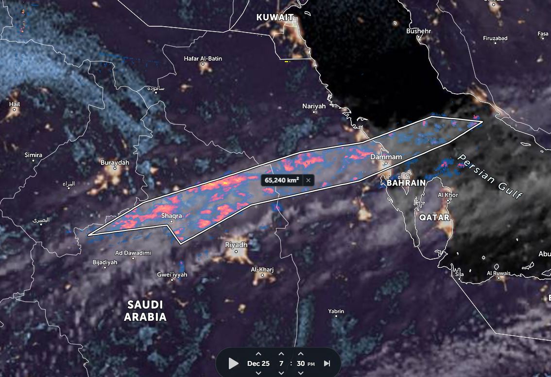
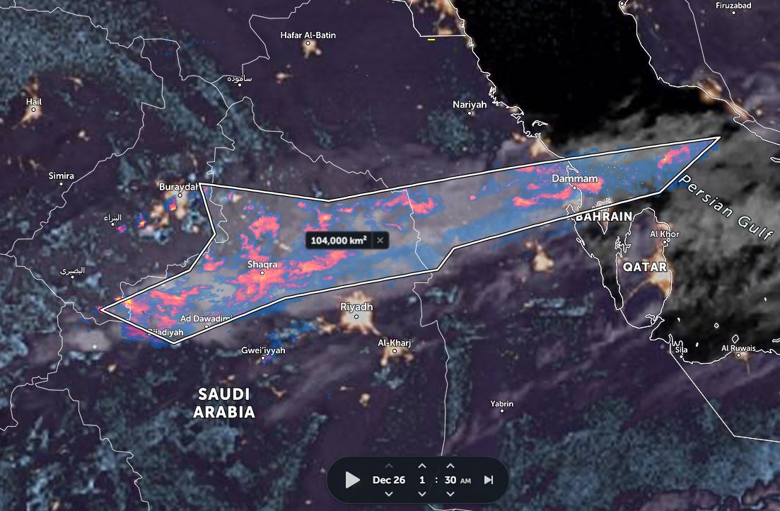
This thread contains forecasts for the main event which begins in earnest in 24 hours time with a developing rain event over the Red Sea Coast South West of Mecca/Makkah. We can see signs of this developing already in satellite imagery in the OP (initial post in this thread).
In this thread I break down the 16 days ahead into three phases which correspond to airborne water pulses coming in all the way from the Amazon - which interact with low pressure storms coming south over Europe in the Middle East.
This IWVT forecast brings all this together.
This IWVT forecast brings all this together.
IVWT stands for Integrated Water Vapour Transport, and its addition to the @weathermodels_ international forcasting package is very timely.
It overlays PWAT (water vapour) MLSP (isobars) and wind data in a single plot. But as it is not that easy to read I will break it down.
It overlays PWAT (water vapour) MLSP (isobars) and wind data in a single plot. But as it is not that easy to read I will break it down.
This larger scale animation shows a much broader picture - and the feature note note here is the pulsating Easterly flows of water over the Sahara from the Tropical Atlantic.
This is today's satellite imagery - 12 hours off the north eastern coast of South America. It shows intense large scale convective storms over the sea as well as outflows from storms over the Amazon rainforest - this is where much of the water appears to be coming from.
This animations, same time frame, shows the visible signs of the atmospheric river that this is producing which arrives in West Africa over Senegal.
Here we see the broader picture showing both the source of the atmospheric river and its outflows. This atmospheric river is well over 10,000kms long, and travels around 9000 kms to the Middle East carried by jet stream winds.
This image completes the picture showing the current trajectory of water transportation over the Sahara. But as you can see in the Africa IWVT animation that trajectory is set to continue to migrate southwards over the coming 16 days.
https://twitter.com/althecat/status/1474416657821016069?s=20
As it migrates south it moves closer to the West African Monsoon which enables it to pick up more moisture on its journey eastwards towards the Horn of Africa and the Middle East.
This CMC model animation shows the PWAT (Water/Energy) component of this puzzle.
This CMC model animation shows the PWAT (Water/Energy) component of this puzzle.

In the animation above you can see 10 days, and the first two pulses of three we can see in the GFS model 16 day forecast, the first of which is developing now.
The remainder of this thread will break what we can see of this event down into three phases.
1. Dec 24 - Dec 29
2. Dec 29-Jan 4
3. Jan 4 - Jan 9
At this stage it looks entirely possible this extreme weather event will continue beyond 16 days. We shall see.
الله أعلم
1. Dec 24 - Dec 29
2. Dec 29-Jan 4
3. Jan 4 - Jan 9
At this stage it looks entirely possible this extreme weather event will continue beyond 16 days. We shall see.
الله أعلم
Phase one's development is apparent in the satellite imagery of the horn of Africa and the Middle East in the OP. We can see a cloud formation over the Red Sea and signs of a north easterly flow of convective outflows towards Makkah.
https://twitter.com/althecat/status/1474408889382805514?s=20
This animation shows forecast rainfall in this initial period - i.e. #Phase1
[Note: Specific rainfall forecast simulation is less reliable at longer range, as here we see the first five days however should be a reliable indication of the beginning of this event.
[Note: Specific rainfall forecast simulation is less reliable at longer range, as here we see the first five days however should be a reliable indication of the beginning of this event.
At the end of this first phase a fresh atmospheric river pulse arrives and #phase2 begins. In the IWVT animation (quoted tweet) you can see this also coincides with the arrival of the first storm from the north - bringing cold air - which causes rain.
https://twitter.com/althecat/status/1474414024087556098?s=20
Here's the PWAT forecast for phase 2 which takes us from 29th December through to January 4th. And here you can see the struggle between the cold air coming in from the north and and the warm wet air which is pushed south into Yemen.
And this is the corresponding rainfall forecast for this period (which is subject to greater error than the large scale dynamics forecasts related to the physic of what is happening in the atmosphere). This forecast suggests heaviest precipitation will be along the Iranian Coast.
Phase 3 begins on or around January 4th in this simulation and is still underway at the end of the current models on January 9th, with what looks like a fourth atmospheric river pulse about to arrive in the region.
And here is the current rainfall solution for this period. Which, is likely to change significantly.
This is good gif to end this on.
It shows us how unusual this is from a climate perspective. Atmospheric water levels are expected to be fairly consistently between 250% and 400% above normal through this period.
This view also shows the phased, wave like nature of this event.
It shows us how unusual this is from a climate perspective. Atmospheric water levels are expected to be fairly consistently between 250% and 400% above normal through this period.
This view also shows the phased, wave like nature of this event.
/ENDS
@Threadreaderapp unroll
@Threadreaderapp unroll
• • •
Missing some Tweet in this thread? You can try to
force a refresh


