The leading edge of the next monsoon charged atmospheric river has arrived in the Middle East and the next phase of unusual possibly extreme winter weather in the region is about to commence. 

The GFS 16-day rain forecast predicts a very similar amount of rain to the last major phase in this extended period of intense #ArabianStorms which finished 2 days ago.
https://twitter.com/althecat/status/1478860199691698182?s=20
For a recap of what has happened so far, this thread from this morning looks at the period 17 December to today, and tracks the Atlantic-Amazon sourced atmospheric river involved in all this all the way to China.
https://twitter.com/althecat/status/1479083256469405700?s=20
The coming week's storms looks to be almost a re-run of the first sequence of #Winter #ArabianStorms which began over the Red Sea on the Christmas Eve.
https://twitter.com/althecat/status/1474426052898398209?s=20
After the atmospheric river coming in across the Sahara from the West intensified, a storm arrived from the North West over Egypt.
The interaction brought rain across Egypt, the Levant, Iraq, Saudi Arabia the Gulf, Iran, Oman the UAE and Pakistan.

The interaction brought rain across Egypt, the Levant, Iraq, Saudi Arabia the Gulf, Iran, Oman the UAE and Pakistan.


Images above show now, and the 11th of January (next Tuesday) as the storm front arrives in Libya.
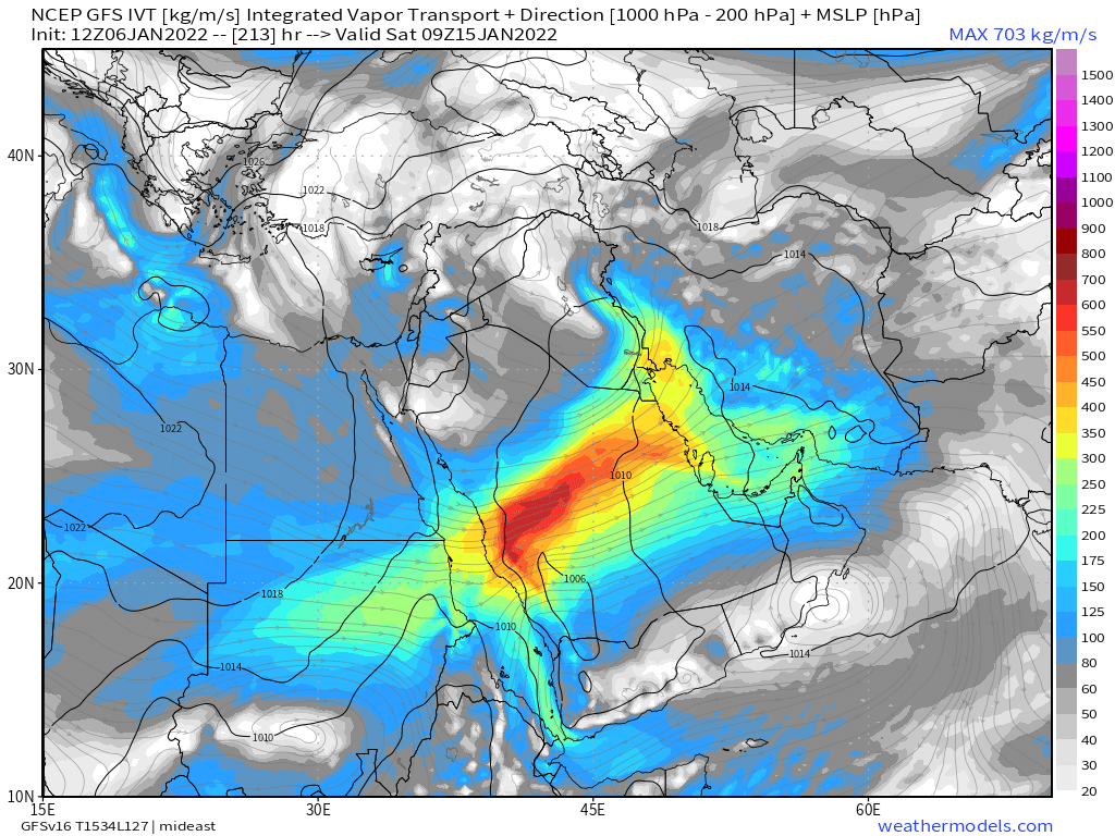
The positioning and timing of elements in this event will evolve, but based on the simulation model runs is expected to be very similar. This image shows Sunday 9th.
The positioning and timing of elements in this event will evolve, but based on the simulation model runs is expected to be very similar. This image shows Sunday 9th.

In this image you see the influence of the storm pulling the atmospheric river north over Sinai, Israel and the Levant. The first significant rainfall event is expected to be here on Sunday. The following day the storm pushes the river south over the Red Sea. 

Rain is possible during this period across the Levant (incl. Jordan and Syria) in the last event the heaviest rains tended to fall over night as the temperature fell. The impact intensity depends a lot on the arrival time and strength of the storm. 

On Tuesday and Wednesday rain is forecast in central Saudi and possibly in Medina.
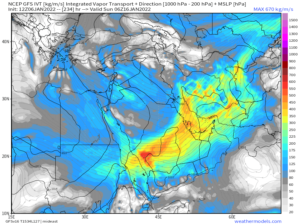
A 2nd Atmospheric pulse is expected to arrive Thursday 13th and we then see a continuous event for several days, moving southwards across central Saudi and over Gulf from Iraq to the UAE.


A 2nd Atmospheric pulse is expected to arrive Thursday 13th and we then see a continuous event for several days, moving southwards across central Saudi and over Gulf from Iraq to the UAE.


Iran which was badly hit in the first event due to its mountains increasing rain intensity, is expected to again receive the highest levels of rain.
The final act takes place over 2 days (16-18 Jan) over the empty quarter, in Yemen, the UAE, Oman, Eastern Iran and Balochistan.

The final act takes place over 2 days (16-18 Jan) over the empty quarter, in Yemen, the UAE, Oman, Eastern Iran and Balochistan.


Note that this is not an official forecast and I am not a meteorologist. All residents in the broader region should prepare for disruption and listen closely to weather warnings from official sources. Further flooding is likely. Tornadoes were seen last time and may be again.
/ENDS
@Threadreaderapp unroll
@Threadreaderapp unroll
• • •
Missing some Tweet in this thread? You can try to
force a refresh


