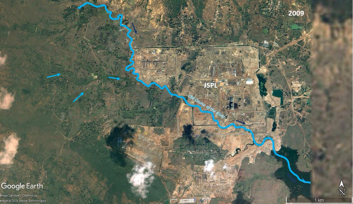
This is a bridge across the #Chambal river near Morena (on the Madhya Pradesh side of the river), massive sand mining operations are happening right below the bridge! So many bridges across India have collapsed because of this activity
More images...
Mining site also seems to be part of National Chambal Wildlife Sanctuary as marked in this SOI toposheet submitted for environmental clearance for a bridge nearby

• • •

Missing some Tweet in this thread? You can try to force a refresh
 

Keep Current with Raj Bhagat P #Mapper4Life

Raj Bhagat P #Mapper4Life Profile picture

Stay in touch and get notified when new unrolls are available from this author!

Read all threads

This Thread may be Removed Anytime!

PDF

Twitter may remove this content at anytime! Save it as PDF for later use!

Try unrolling a thread yourself!

how to unroll video
  1. Follow @ThreadReaderApp to mention us!

  2. From a Twitter thread mention us with a keyword "unroll"
@threadreaderapp unroll

Practice here first or read more on our help page!

More from @rajbhagatt

Feb 14
#Thread
Story with maps about Vaan Theevu, a small island off the coast of Thoothukudi, Tamil Nadu.

Animation shows how much the Island has changed over last 3 decades. It has been shrinking for a while.

Here's my take on the subject. Please do read this long thread!
1/n
2)Vaan is one of the many islands found off the coast in Gulf of Mannar. The island along with others are now protected areas.

Vaan island is in the shallow continental shelf part of sea. 3 islands existed to south of it but they were all merged/modified for construction of port
3) Here's a visualization of the sea floor around the island. The island is actually in the leeward side of a reef platform that is ~4km from the coastline.

Though the origin of the platform is unclear, the island originated because of the platform
Read 22 tweets
Feb 2
#Thread: Here are my views on use of satellite images & maps in the Economic survey 2022.

Overall I have a mixed feeling. I am so glad and delighted that a section has been devoted in this manner but I am not happy how certain maps have been presented as they tend to mislead
One of the most highlighted map in the survey was that of night lights. It left many wondering whether India actually grew this way. The answer is no and yes. Night lights did increase over the longer period but it is way exaggerated in this map
Night lights data based on VIIRS usually comes in form of radiance values. Visualization settings of these radiances would alter how bright our cities look. For example, the image below shows min:0 , max: 3 for India in 2013
Read 18 tweets
Jan 21
To protect the borders in #Kanniyakumari District, Travancore kindgom under guidance of Capt. Eustachius De Lannoy built South Travancore lines - a series of fortifications in ~1740s between the ocean & mountains & are now in ruins after being overrun by Company troops in 1809
Except Vattakottai fort, all the other sections of the lines are present as bunds or demolished and now used as roads. Some ruins of the bastions and redoubts are still visible in some places.

Google Earth/Maxar Rendition of Vattakottai fort overlooking the sea.
#Tamil version map of the same
Read 4 tweets
Jan 13
India - State of #forest report from Forest Survey is out. If you get news articles (how forest covr increased/decreased), read it with caution. Will write detailed comments later, but some small fun for now:

In ch-13 maps, they have given Shaksgam away! Illegal to publish..
1/n
They had some city level maps of forests.. And their statistics depended on boundary files and the file for Mumbai is riddled with gaps between subdivisions. There are white patches in between because someone didnt digitize it properly and these errors creep into stats
For the other major cities, the boundaries used were municipal corporation boundaries but for Bengaluru alone they have used planning area boundary (BDA has a larger area than BBMP and covers some forest patches). Comparison shown below and this would affect numbers
Read 9 tweets
Jan 7
#Thread of maps on Palayamkottai, now part of #Tirunelveli

As a city,Palayamkottai has a recorded history for more than a thousand years. It reached its zenith during the British era & was called as "Oxford of South India"

My first thread in 2022 is a tribute to #ThoPa
Palaymkottai was located in KeelKalaKootram, a revenue division in the east side of Porunai river (now called Thamirabarani). The fort itself was positioned to protect the lush farmlands & was at the intersection of the farmlands & pastures which designed its socio-cultural setup
Before the 1700s, the city was largely confined within the fort walls. But it had began expanding outside afterwards. The fort was a largely rectangular shaped structure with a number of bastions and four gates in four directions.
Read 12 tweets
Dec 27, 2021
Time for another short story

A small river/stream existed near Angul #Odisha. The land around it was allotted to JSPL for development...
The company thought the course of the river was too disturbing and decided to change the course of the river.
However there were other smaller streams that were draining into it (obviously) & since the new course didnt account it, they started stagnating (marked in white circle)
No matter how much they filled the land, it continued stagnating and creating issues for authorities and farmers nearby.
Read 5 tweets

Did Thread Reader help you today?

Support us! We are indie developers!


This site is made by just two indie developers on a laptop doing marketing, support and development! Read more about the story.

Become a Premium Member ($3/month or $30/year) and get exclusive features!

Become Premium

Don't want to be a Premium member but still want to support us?

Make a small donation by buying us coffee ($5) or help with server cost ($10)

Donate via Paypal

Or Donate anonymously using crypto!

Ethereum

0xfe58350B80634f60Fa6Dc149a72b4DFbc17D341E copy

Bitcoin

3ATGMxNzCUFzxpMCHL5sWSt4DVtS8UqXpi copy

Thank you for your support!

Follow Us on Twitter!

:(