A word on Ukraine's favorite front, the #Kharkhov front. Wanting to first comment on the more critical areas, did not get a chance yet to comment on this upon my return, but may be indicative of a significant change. Until now, as hard as it might be to believe, the official
territorial claims of both countries, specifically the MoDs has been relatively accurate and matching. Of course with plenty of exceptions, especially when there is still fighting in a town or city, one or both parties have prematurely claimed control over it. And while Ukrainian
military claims & PR efforts can be & often are fantastical (Ghost of Kiev, Snake Island etc), & both MoDs have been known to issue incorrect information, what I am referring to is that there has not been widely differing claims (of many kilometers & several towns/cities deep)
of the front line. In general, by following both MoDs, one will get a fairly accurate (if somewhat delayed) picture of where the front line is. If we add reliable sources of each camp, then if one knows how to filter through it, we get an even more accurate and more up to date
picture. Reviewing the days events while I was incommunicado I see signs of this pattern breaking, especially on the Kharkhiv front but elsewhere as well. This may indicate that one (or both) of the parties is lying more than previously and may indicate a certain desperateness.
We shall see if that turns out to be a new pattern or not. In any event, the quick example here, according to #Ukrainian sources, the northern front all along the #Kharkhov front is near or at the #Russian border. However, we see recent thermal activity pointing to what appears
to be yet another Russian counterattack (in this sparsely populated front on the side of the RU forces) that is heading southwards and is threatening the T2104 highway (the Kharkhov - Staryi Saltiv road). Targets seem to be Shestakove and Fedorivka amont other areas.
Specifically the advances seem to be along the ridges and around Ruski Tyshky an effort to cut off any forces still north with the forest on their western flank. It is difficult to reconcile what we see here with the Ukrainian account of what is happening on this front.
An even stranger situation occurs east of the wide part of the Siverskyi Donets River. What is actually happening on this front is far from clear to me, and will update further as it gets clearer. What seems to be the case however is that it is a troop-trap for some of the best
Ukrainian units who advance and retreat here repeatedly, rather than holding the crumbling front in the Donbass.
• • •
Missing some Tweet in this thread? You can try to
force a refresh
In other news, unrelated to war in #Ukraine, #Ukrainian forces thrust 80Km south through an entrenched & long static front line and are near capturing a strategic & large Russian speaking city, #Melitopol, severing the communication lines between Crimea and Donetsk.
I thought this one was too much, even for the @KyivIndependent, but usually there is some real-life event that inspires their fantastical claims. It must be this. There is apparently an offensive or attempt at one in this front. You can see roughly the front, Melitopol far to the
south, and very recent (mostly last hour or two) strikes and fires at #Russian held #Polohy. The industrial area around the rail freight terminal is the main target and was already hit by a drone ~2 days ago as we see in this UA released video. These may be secondary fires
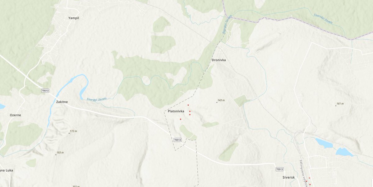
Quick update. The attack on #Bohorodychne (crossing attempt) by #Russian forces has intensified. Further west, there is a RU effort to push the front line further south south away from the railway and highway (R78). Further east there may be preparation to cross near #Platonivka
where the Siverskyi river is narrow & it is somewhat less expected (as opposed to trying to go straight east from Ozerne to Zakitne or to cross at Dronivka where the bridge was blown). RU forces here are close to Yampil railway station for supplies. With Lyman in #Russian hands
this rail line now connects with #Izium and through Sosnove directly north to the main hub at Kupyansk. Finally there is another potential crossing attempt (or preparation or faint) at Pryvillia. This advance would also be close to the rail line at Kreminna that directly connects
Back from travel, let's get to reporting on what doesn't get reporting. This morning, heavy #Russian shelling south of the Siverskyi in #Bohorodychne & #Svyatogorsk indicate fast advance on this sector. By the thermal footprint history, it appears RU now controls or is near
controlling Svyatogorsk (on the north bank), and is now attacking the south bank both here, and further west at Bohordychne. Both of these towns have river crossings that were standing as of our last information. Sat images from the 31st of May indicate the eastern bridge was
intact and the western one was likely standing. The UA forces may have blown them since (as they often do before retreating), but it seems likely that they did not as Russia is attempting to cross south at these positions. The strategic value is important. Earlier in the conflict
Here we have it folks (suggest reading the entire prev thread for context). As I speculated, the #Ukrainian forces, with or without permission, withdrew from the #Svitlodarsk front, with fortifications that had held for 8 years. The city is in #Russian hands. Geolocated here.
This previously overlooked southern salient of #Popasna, rather than the northern one, was discussed earlier in this thread and in deed has fallen much faster, due to its inherent danger (to UA forces) and greater tactical vulnerability. By withdrawing,
the #Ukrainian forces avoided certain encirclement and another mass surrender event. The two important cities, the dam and its power plant however are now in Russian hands. Was the UA withdrawal call correct? Well here is reported collaboration of the UA General Staff:
Speaking of the difficulty of blowing up dams (& bridges on top of them) & whether #Ukraine would cause such flooding & havoc on its own settlements, I guess we have the answer. #Ukrainian forces attempted to blow up the Vuhlehirske dam on the #Luhan / Lugan river. Geolocated blw
Destroying the dam would have caused great damage and likely death in #Svitlodarsk & surrounding settlements. This was done to slow down the Russian advance as the UA front here is collapsing. As we discussed earlier, Svitlodarsk & Myronivksyi were in danger of being cut off.
From the southeast, these cities were protected with entrenchments such as these two facing the RU forces (& these are just what existed before the war). This important front & cities could be taken by RU forces by an advance on their rear to cut the E40
One of the most puzzling reports of the war thus far: For days now we have heard about a #Ukrainian bridgehead east of the river. We keep hearing UA has captured #Zarichne & #Metalivka. Also that they are holding Verkhnia Pysarivka on the way to strategic #Vovchansk.
This is wishful reporting (on their part). There is no bridge and in my view, no bridgehead either.
New Sat images confirm for us, as of May 23 and as I suspected, that there is no bridge anywhere. The bridge at Staryi Saltiv is still down. There is no bridge anywhere near the captured villages in the wide (dammed) part of the river. Neither is there one further north.