1/ #Thread
#Sanskrit was not limited to India it was far spread upto Cambodia, Indonesia, Myanmar, Thailand, Vietnam 2000 years ago let's see the reach in this #Thread
*Map not political
Src #wikiwand
#Archaeology
#Sanskrit was not limited to India it was far spread upto Cambodia, Indonesia, Myanmar, Thailand, Vietnam 2000 years ago let's see the reach in this #Thread
*Map not political
Src #wikiwand
#Archaeology

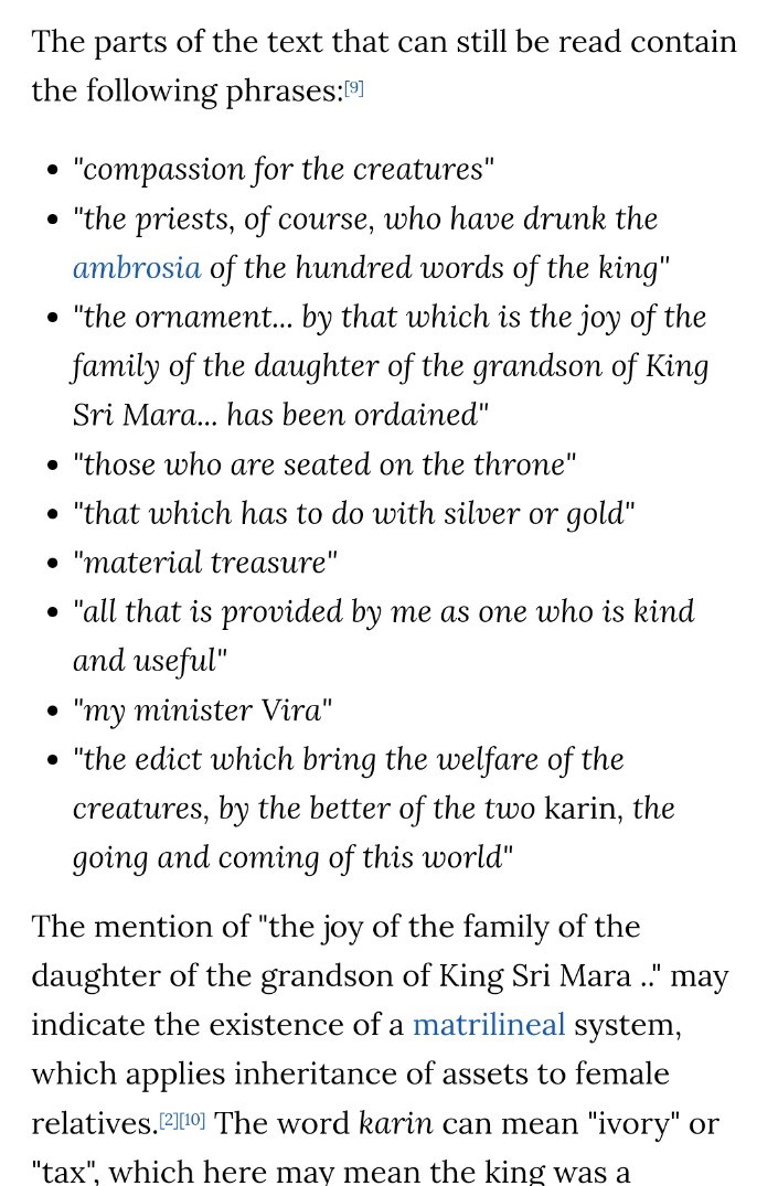
2/ The earliest surviving Sanskrit inscription is from Vo Canh inscription discovered near Nha Trang, Vietnam dates 3rd century ce
The inscription ordains grand daughter of King indicating a Matrilineal society.
#Archaeology
wikiwand.com/en/V%C3%B5_C%E…
m.phnompenhpost.com/post-plus/epig…
The inscription ordains grand daughter of King indicating a Matrilineal society.
#Archaeology
wikiwand.com/en/V%C3%B5_C%E…
m.phnompenhpost.com/post-plus/epig…

3/ Yūpa Mulawarman (H!ndu king) inscription in Indonesia written by Brahm!ns in Pallava Script, Borneo, Kutai, Indonesia
Dates 4 century ce
This attests to the emergence of an Indianized state in the Indonesian archipelago.
wikiwand.com/en/Y%C5%ABpa#/…
Dates 4 century ce
This attests to the emergence of an Indianized state in the Indonesian archipelago.
wikiwand.com/en/Y%C5%ABpa#/…

4/ Kebon Kopi or 'Tapak Gajah inscription', Indonesia dating 5th century ce describes elephant ride of King Purnawarman of Tarumanagara, which is equated with Airavata, the elephant vahana (vehicle) of Indra.
#Archaeology
wikiwand.com/en/Kebon_Kopi_…
#Archaeology
wikiwand.com/en/Kebon_Kopi_…


5/ Tugu inscription in Pallava script in Sanskrit dates 5th century ce found in Batutumbuh hamlet, Tugu village, Koja, Indonesia
It describes hydraulic, irrigation and water drainage project of Chandrabhaga river by Rajadirajaguru
#Archaeology
wikiwand.com/en/Tugu_inscri…
It describes hydraulic, irrigation and water drainage project of Chandrabhaga river by Rajadirajaguru
#Archaeology
wikiwand.com/en/Tugu_inscri…

6/ Cidanghiang inscription, also called Lebak inscription, from Tarumanagara kingdom, estimated to be from the 4th century CE, Banten, Indonesia
It is abt a king Purnawarman, with title vikrānta, who was worshiper of Lord Vishnu.
#Archaeology
wikiwand.com/en/Cidanghiang…
It is abt a king Purnawarman, with title vikrānta, who was worshiper of Lord Vishnu.
#Archaeology
wikiwand.com/en/Cidanghiang…


7/ Prasasti Ciaruteun Inscription is 5th-century stone inscription discovered on the riverbed of Ciaruteun River, aWest Java, Indonesia.
The inscription states King Purnawarman is the ruler of Tarumanagara (An early H!ndu Kingdom)
#Archaeology
wikiwand.com/en/Ciaruteun_i…
#Archaeology
The inscription states King Purnawarman is the ruler of Tarumanagara (An early H!ndu Kingdom)
#Archaeology
wikiwand.com/en/Ciaruteun_i…
#Archaeology

8/
Sanskrit inscription in Early Pallava script on a stone lying on the Pasir kole-angkak hill, Jambu, to the west of Bogor, Indonesia
C.5th century ce
#Archaeology
…italcollections.universiteitleiden.nl/view/item/84279
Sanskrit inscription in Early Pallava script on a stone lying on the Pasir kole-angkak hill, Jambu, to the west of Bogor, Indonesia
C.5th century ce
#Archaeology
…italcollections.universiteitleiden.nl/view/item/84279

9/
"Suvarnbhumi" "सुवर्णभूमि" found inscribed in 'Sanskrit' on a 7th century slab in Cambodia
#Archaeology
"Suvarnbhumi" "सुवर्णभूमि" found inscribed in 'Sanskrit' on a 7th century slab in Cambodia
#Archaeology

10/
Indonesian non-royal Sanskrit inscription dating 7th century describing how Sankara fulfilled his promise to his father to house a Linga 'representation of Shiva'
#archaeology
brill.com/view/journals/…
Indonesian non-royal Sanskrit inscription dating 7th century describing how Sankara fulfilled his promise to his father to house a Linga 'representation of Shiva'
#archaeology
brill.com/view/journals/…


11/
Ligor inscription is an 8th-century stone stele or inscription discovered in Ligor, Nakhon Si Thammarat, Southern Thailand Malay Peninsula.
written by Mahārāja dyāḥ Pañcapaṇa kariyāna Paṇaṃkaran, king of Shailendra dynasty
#archaeology
wikiwand.com/en/Ligor_inscr…
Ligor inscription is an 8th-century stone stele or inscription discovered in Ligor, Nakhon Si Thammarat, Southern Thailand Malay Peninsula.
written by Mahārāja dyāḥ Pañcapaṇa kariyāna Paṇaṃkaran, king of Shailendra dynasty
#archaeology
wikiwand.com/en/Ligor_inscr…

12/
Sanskrit inscription found in Trowulan, Melang dating c.966 ce
#Archaeology
journals.openedition.org/archipel/1976
Sanskrit inscription found in Trowulan, Melang dating c.966 ce
#Archaeology
journals.openedition.org/archipel/1976


13/ Singapore Stone inscription written in Sanskrit 10th-13th century originally stood at the mouth of Singapore river to be blown by Britishers in 1843 to widen the river pathway
#archaeology
wikiwand.com/en/Singapore_S…
#archaeology
wikiwand.com/en/Singapore_S…

14/
Few sanskrit writings found on pillars of Angkor Wat, Ta Nei, Kravan and Koh Ker temples Cambodia
#Archaeology
angkorphotographytours.com/blog/sanskrit-…
Few sanskrit writings found on pillars of Angkor Wat, Ta Nei, Kravan and Koh Ker temples Cambodia
#Archaeology
angkorphotographytours.com/blog/sanskrit-…

15/
Laguna copperplate inscription is an official acquittance inscribed onto a copper plate in the Shaka year 822 (Gregorian A.D. 900).
It is the earliest known calendar-dated document found within the #Philippines
#Archaeology #philippinehistory
en.wikipedia.org/wiki/Laguna_Co…
Laguna copperplate inscription is an official acquittance inscribed onto a copper plate in the Shaka year 822 (Gregorian A.D. 900).
It is the earliest known calendar-dated document found within the #Philippines
#Archaeology #philippinehistory
en.wikipedia.org/wiki/Laguna_Co…


16/
Sawlumin inscription is one of the oldest surviving stone inscriptions in Myanmar. The slabs were mainly inscribed in Burmese, Pyu, Mon and Pali, and a few lines in #Sanskrit. the stele was founded in 1079 by King Saw Lu of Bagan.
#archaeology
en.wikipedia.org/wiki/Sawlumin_…
Sawlumin inscription is one of the oldest surviving stone inscriptions in Myanmar. The slabs were mainly inscribed in Burmese, Pyu, Mon and Pali, and a few lines in #Sanskrit. the stele was founded in 1079 by King Saw Lu of Bagan.
#archaeology
en.wikipedia.org/wiki/Sawlumin_…

17/
5.1 Engraved copper sheet of Harsavarman with Sanskrit inscription K.964 found in the ancient moat of U Thong, #Thailand;
5.2. Stone inscription in Sanskrit K.1155 found at Ban Phan Dung, #Thailand
c.7-8th century
#Archaeology
researchgate.net/figure/51-Engr…
5.1 Engraved copper sheet of Harsavarman with Sanskrit inscription K.964 found in the ancient moat of U Thong, #Thailand;
5.2. Stone inscription in Sanskrit K.1155 found at Ban Phan Dung, #Thailand
c.7-8th century
#Archaeology
researchgate.net/figure/51-Engr…

18/
#Sanskrit Inscription found in Brunei, a tiny nation on the island of Borneo, in 2 distinct sections surrounded by Malaysia and the South China Sea Brunei
#Archaeology
jstor.org/stable/41492843
#Sanskrit Inscription found in Brunei, a tiny nation on the island of Borneo, in 2 distinct sections surrounded by Malaysia and the South China Sea Brunei
#Archaeology
jstor.org/stable/41492843


19/
300 CE stone inscription in Sanskrit read
"This is a few feet like the feet of Vishnu. They are the glorious footprints of Purnawarman, the great king of the land of Taruma, the valiant king of the world.”
Bogor, Java, Indonesia
#archaeology
kris-keris.eu/page/mystiek
300 CE stone inscription in Sanskrit read
"This is a few feet like the feet of Vishnu. They are the glorious footprints of Purnawarman, the great king of the land of Taruma, the valiant king of the world.”
Bogor, Java, Indonesia
#archaeology
kris-keris.eu/page/mystiek

• • •
Missing some Tweet in this thread? You can try to
force a refresh