Major movement of Russian equipment identified in 25 August 2022 imagery near #Kherson crossing the #Dnipro river. About 100 military vehicles seen moving in imagery, mostly northwards toward Kherson, at 08:48 UTC (11:48 Kyiv time) on 25 August. 1/
At the edge of the image, we can see a convoy of at least 40 military vehicles waiting to move northward near the intersection at 46.6439 32.8159. 2/
10 more Russian military vehicles wait at the military pontoon ferry landing point at 46.6614 32.8037 3/
A pontoon ferry with 14 military vehicles is seen crossing southward in the #Dnipro river at 46.6723 32.7943, about to enter the Konka river. 4/
The northern military pontoon ferry landing point was empty - since the vehicles just departed - but nearby, west from the point, a queue of 24 more military vehicles were waiting to cross south at 46.6768 32.7844. 5/
Further west, we find 5 more Russian military vehicles on side of the road in Kherson at 46.6764 32.7308 6/
Looking at the north side of #AntonovskiyBridge we can see a Russian construction vehicle smoothing the ramp to the barge bridge at 46.6746 32.7199 /7
And finally, we can see on the south side of #AntonovskiyBridge extensive damage to the surface of the bridge at 46.6664 32.7204. Somewhere around 16 distinct holes are visible. /8
It seems the Russians are really struggling to move equipment, if they're forced to move so much by cargo truck via slow, vulnerable ferries. Without the bridges, their resupply operations are hanging by a very thin thread. 🧵✂️ /9
• • •
Missing some Tweet in this thread? You can try to
force a refresh
Looks like the Russians finished creating a barge bridge over the #Dnipro near #Kherson in the past 24 hours. Imagery from Oct 18 show a barge pushing the last parts into place at 0814 UTC. This allows Russia to resupply faster or to evacuate quickly. It's also an easy target.🤔
@GeoConfirmed Barge bridge complete at #Kherson on 18 October. Last barge being placed at 46.6658 32.7206.
And on the 17th there was more activity of Russian military vehicles waiting while others crossed by ferry. Same waiting location in a field around 46.7 32.8, just north of Prydniprovs'ke, east of #Kherson. Lots of trucks headed away from Kherson.
Since Aug, 70km of a natural gas pipeline was laid between #Melitopol and Marynivka, #Zaporizhia Oblast, #Ukraine. This will likely connect to #Berdyansk. Melitopol has been without gas for months. The connection could be complete within the next few weeks. @GeoConfirmed
A KML version of the pipeline trace can be downloaded here for import into your favorite mapping tools. This was created based on satellite imagery from August and September 2022. drive.proton.me/urls/TES5W9RE8…
The occupation government in #Luhansk, #Ukraine is pushing people to a telegram channel to get info about the referendum. Good #OSINT feed? t.me/budem_zhit 🤔
Apparently the LPR occupation authorities need to take a break while counting the ballots...
"The Department of the People's Militia of the Luhansk People's Republic reports that during the period of the referendum, the departments of the military commissariat will not work."
Situation around #antonovskiybridge in #Kherson hasn't changed. Sep 15 images show the ferries in use nearby, and empty barges. But... 🧵 1/
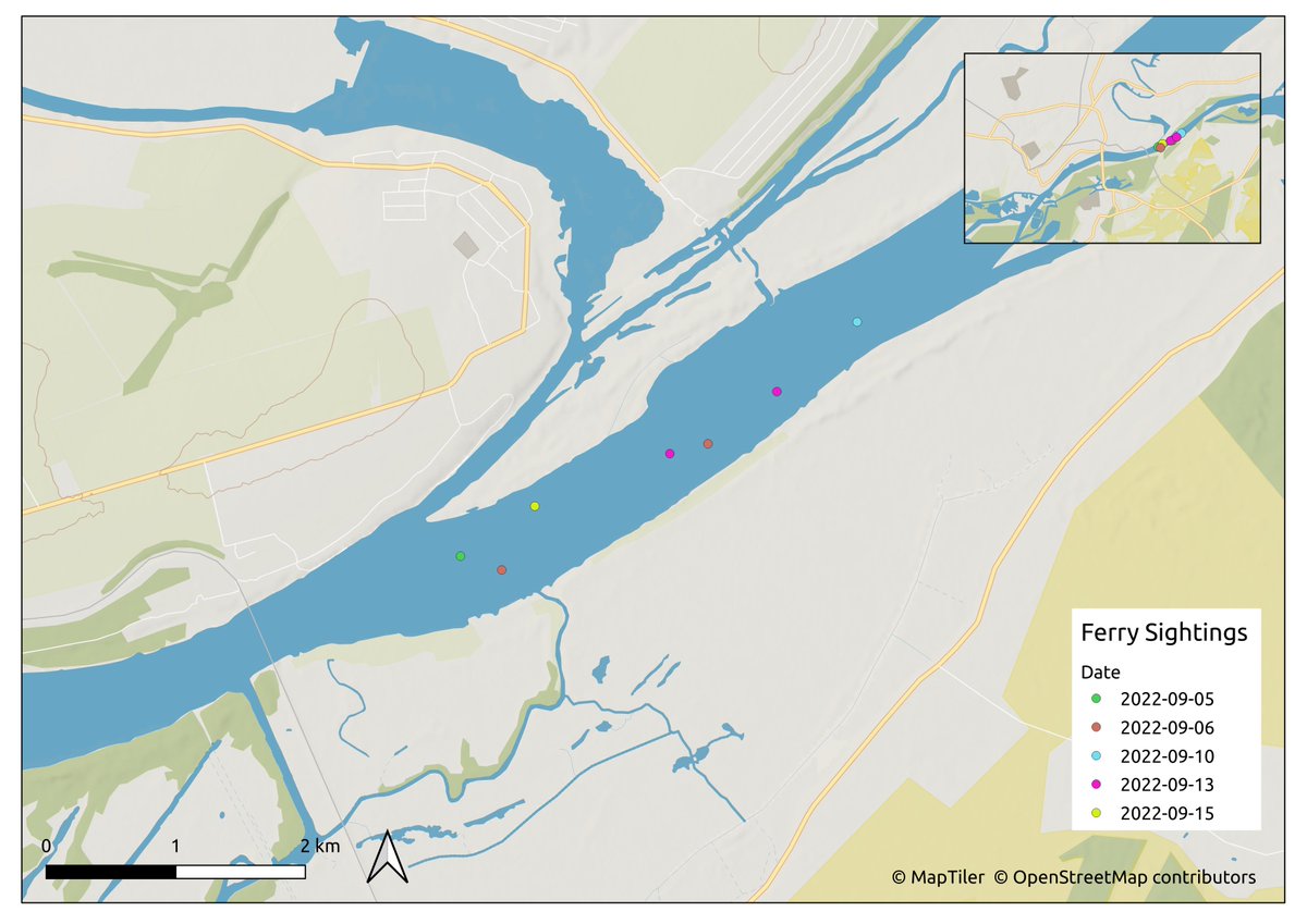
Looking back at radar and optical imagery since Sep 6 we can see many boats, some confirmed as pontoon ferries, operating east of the rail bridge near #Kherson. Here's a map with the locations plotted on different dates. Where does the ferry land? 🤔2/
Looking at imagery over #Kherson for 31 Aug we can see more Russian military vehicle movement than ever before. In this first image, we can see ~20 vehicles on the pontoon ferries transiting in each direction near 32.8035 46.6614.🧵 1/
11x Russian military vehicles waiting at 46.6442 32.8161 to move up the queue towards the military ferry across the #Dnipro 2/
16x Russian military vehicles queuing at 46.6287 32.8075. 3/
After reviewing satellite photos from the past few weeks, I think @secretsqrl123 was right when he highlighted this location as the possible southern ferry point for the Russian military across the #Dnipro river. 1/
Imagery from 7 and 24 August show military vehicles near 46.660 32.804. Images from this month show military vehicles traveling along this dead-end road. This is likely the southern pontoon point for Russian military vehicles on the #Dnipro near #Kherson. 2/
The other end is 1.9 KM away at 46.6761 32.7902. This makes more sense than going further up the Konka river. 3/