📢NEW PUBLICATION in Forest Ecology and Management: Pre-fire measures of boreal forest structure and composition inform interpretation of post-fire spectral recovery rates #OpenAccess #forestrecovery #boreal #fire
doi.org/10.1016/j.fore……
A short 🧵 follows...
doi.org/10.1016/j.fore……
A short 🧵 follows...

Spectral recovery=# of yrs reqd for pixel to attain 80% of its pre-disturbance NBR value (Years to Recovery, Y2R). NBR=Normalized Burn Ratio, which exploits differences in spectral response of vegetation & exposed soil in NIR and SWIR wavelengths. Enabled by #Landsat time series. 


We used an #opendata synthesis of #boreal pre- & post-fire field measurements shared by Baltzer @forestecogrp et al. (2021). Incredibly useful data for examining drivers of spectral #forestrecovery post-fire.
Paper: doi.org/10.1073/pnas.2……
Data: doi.org/10.3334/ORNLDA…
Paper: doi.org/10.1073/pnas.2……
Data: doi.org/10.3334/ORNLDA…
Plots w/ an absolute decrease in stem density post-fire had significantly longer median recovery rates (17 yrs) compared to plots that experienced no change (8 yrs). Likewise, the % of field plots that experienced a decrease in stem density increased with increasing Y2R. 


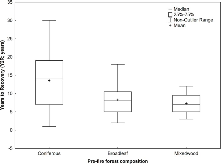
Coniferous-dominated plots pre-fire had significantly longer median recovery rates (14 yrs) compared to broadleaf-dominated (8 yrs) plots. Compositional shifts among coniferous, broadleaf, and mixedwood classes varied by 5-year Y2R epoch & for not recovered plots. 


Plots that had not yet spectrally recovered by the end of the #Landsat time series were associated with higher elevations, drier sites, greater pre-fire basal area, & greater change magnitudes. They were also more likely to have been labelled in the field as regeneration failure.
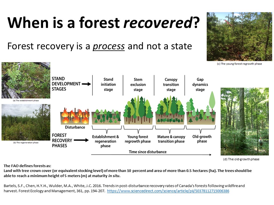
Our results emphasize that post-fire #forestrecovery in the #boreal is a process that is highly variable and that knowledge of pre-fire condition is useful for characterizing and interpreting measures of post-fire spectral recovery. #OpenAccess
doi.org/10.1016/j.fore…
doi.org/10.1016/j.fore…
@threadreaderapp unroll
• • •
Missing some Tweet in this thread? You can try to
force a refresh


