Zeke Lunder ~ The Lookout Profile picture
Jul 7 11 tweets 5 min read Read on X
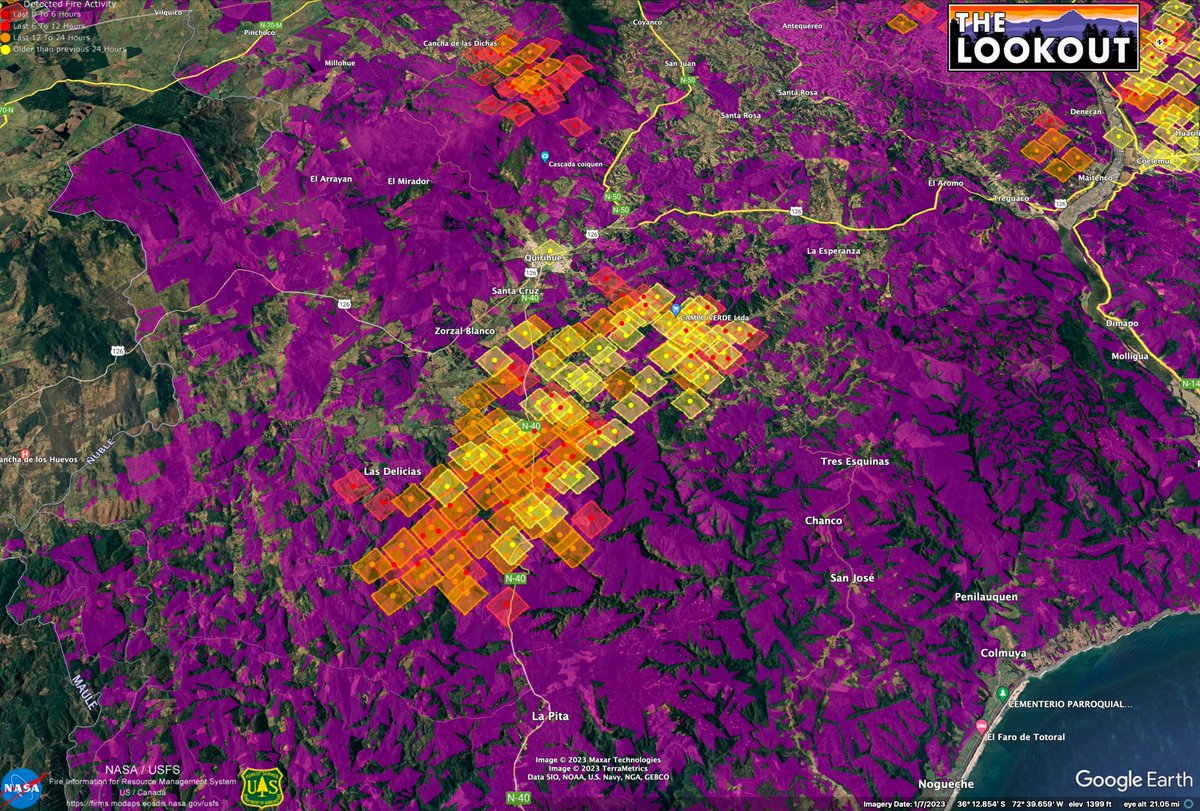
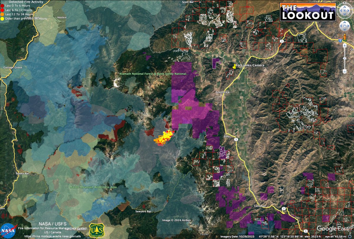
There is an interesting story to tell about land conservation, forestry, global carbon markets, and lands threatened by tonight's growth on the #ShellyFire, (captured by @ALERTCalifornia . 23:00 - 7/6/24) 1/x
The #ShellyFire is pushing east out of the Marble Mountains into a large tract of private timberland owned by @EFMInvest - a 'Climate Smart' private equity management group (subsidiary of Ecotrust) (purple on the map). Previously the land was held by an Investment company called Timbervest. 2/xImage
Image
Image
EFM has sold 'carbon credits' on this land. They are able to do this because they claiming that by not logging it, it will grow and store a lot more carbon than it would if it were logged (they can sell the 'additionality'). 3/x acr2.apx.com/mymodule/Proje…
Image
Over the past 5 years or so, EFM has teamed up with Siskiyou Land Trust to get Cal Fire and other grantors to fund putting 40,000 acres of their land into a 'Conservation Easement'. So California taxpayers are helping finance this scam. 4/x Image
This looks good on paper. But promsing to 'further enhanc(e) conservation values and climate resilience for all who inhabit and visit this vast landscape' while adopting a forest management strategy which aims to maximize the amount of carbon (fuel) on the site seems absurd. 5/xImage
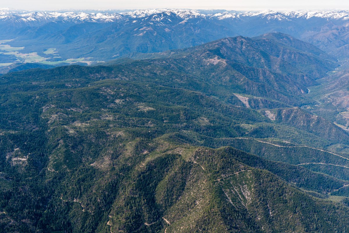
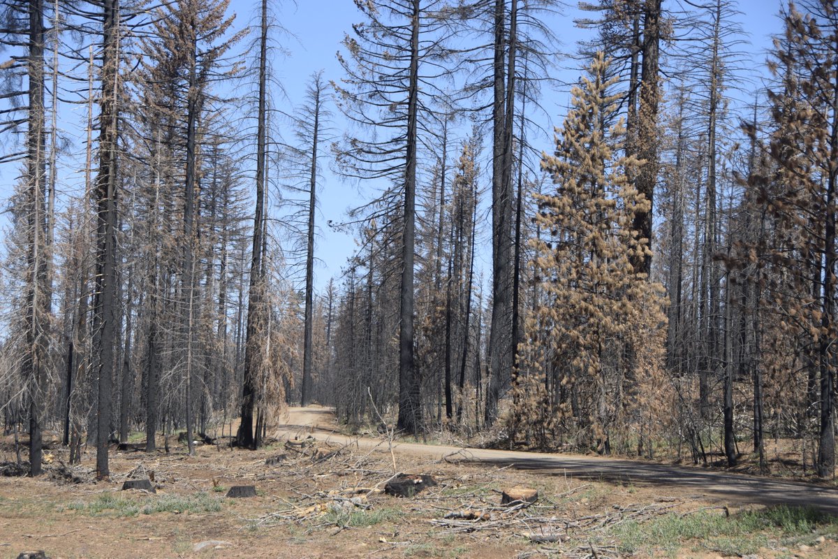
Much of the landscape in the 40,000 acres recently placed into conservation easements here has not burned for 70 years or more, and as a result is covered with extremely over-stocked, sick forests. Yet carbon pirates like EFMI hawk them as 'Undervalued Carbon Assets'. 6/xefmi.com/why-invest/Image
Image
Conservation groups, carbon bankers, and industrial timberland owners all face an existential challenge: How can you maintain conifer forests in fire-prone landscapes without re-introducing mixed-severity fire at scale? (You can't). Map shows fire history adjacent to EFM lands. 7/xImage
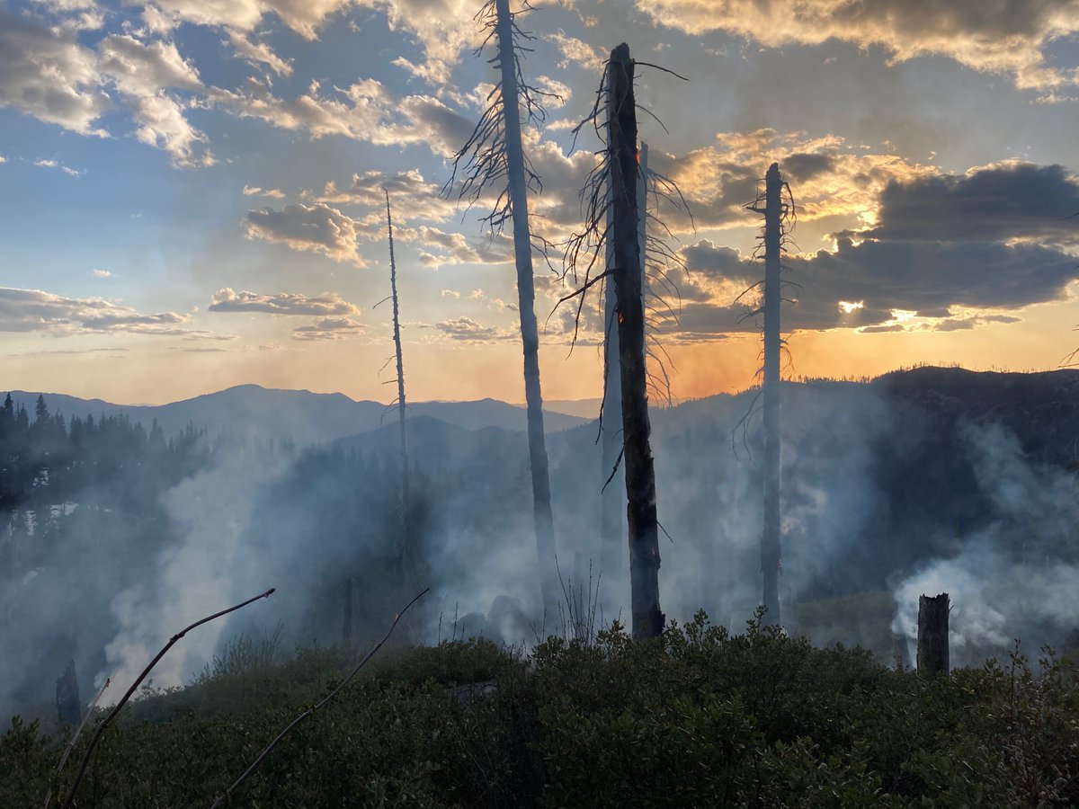
You can't sell dry forests as a 'tool to decarbonize infestment portfolios' unless you are willing to do the work of making them fire resilient again. Any many of us who work in the woods are not sure this is even possible at this point. #YourCarbonIsGettingSmoked 8/x Image
The presence of overstocked private timberlands on the margins of the backcountry ends out being a huge obstacle to letting beneficial lightning fires burn out there. The impacts of the carbon nerds' shenanigans extends well beyond the boundaries of their (stolen) lands. 9/x
Image
Image
@threadreaderapp unroll
Man, there are a lot of typos in this thread...

• • •

Missing some Tweet in this thread? You can try to force a refresh
 

Keep Current with Zeke Lunder ~ The Lookout

Zeke Lunder ~ The Lookout Profile picture

Stay in touch and get notified when new unrolls are available from this author!

Read all threads

This Thread may be Removed Anytime!

PDF

Twitter may remove this content at anytime! Save it as PDF for later use!

Try unrolling a thread yourself!

how to unroll video
  1. Follow @ThreadReaderApp to mention us!

  2. From a Twitter thread mention us with a keyword "unroll"
@threadreaderapp unroll

Practice here first or read more on our help page!

More from @wildland_zko

Aug 15, 2023
Just got some remarkable video from toe of the landslide caused by PG&E's Butte Creek Canal collapse last week. Thousands of yards of dirt and rock dammed up Butte Creek. This entire gravel bar is new. Sediment threatens endangered salmon which begin spawning in next 60 days. /1
The landslide went all the way across the creek and created a dam which backed up the creek. When it overtopped, it lead to the initial huge pulse of orange sediment seen downstream the next morning. /2
It's important to point out this is not the first time this has happened. LiDAR terrain maps show this has happened over a dozen times since the flume was built during the gold rush. The canal is deteriorating, and poses a continued liability to the survival of the salmon run. /3
Read 4 tweets
Jul 16, 2023
So #wildfire season is finally starting to take off in Northern California. Here is a thread on why it has taken this long, and what it takes for us to have large fires in California: #CaFires #CaWx #WildlandFirefighting 1/
California has so many fire suppression resources it is hard for fires to escape initial attack unless at least one of these criteria is met:
Multiple starts across a wide area
Above average winds
Topographic alignment
Extreme temperatures
Poor visibility for aircraft 2/
Massive airpower for firefighting in Ca. means an individual fire can have half a dozen air tankers on it within the first hour. There are heavy helicopters stationed all over the state, too, and these are extremely effective on initial attack if they can refill nearby. 3/
Read 18 tweets
Feb 4, 2023
The large #wildfires in #Chile are spreading quickly across large areas of non-native plantations of radiata pine and eucalyptus, many of them planted by foreigners during a dictatorship. These maps show recent MODIS heat detections on top of mapping of plantations (purple). 1/x
Over 3 million acres of plantations were established in this region in the 80s and 90s. As seen in the American West, during severe weather, conifer tree farms burn like the sun. Even-aged forestry is turning out to be an ecological disaster, all over the globe. 2/x Source: Patagon Journal
The @FSC_IC has certified over 3M acres of Chilean plantations as being 'sustainably managed'. But as in the USA, they failed to imagine the potential scale of wildfire losses in managed forests. Wildfire is a structural problem in tree farms, not easily mitigated. 3/x
Read 8 tweets
Jan 21, 2023
First cloud-free #Sentinel2 satellite images in a month dropped yesterday. Great to check out snow levels, reservoirs, and wet wet wet in the Butte Basin/Lower Sacramento River. First image compares Colusa area now vs 12/15/2022. #Geography #RemoteSensing #CaWx #CaStorm 1/x
Imagery paints a picture of soil types. Along the River, coarser soils settle quickly once floodwaters slow down. Blue areas have more clay, because super-fine soil particles can stay suspended longer, travel farther in slow-moving floodwaters. Orchards prefer coarse soils. 2/x
Plumes of sediment from the Pajaro and Salinas Rivers are still very visible in the Monterey Bay on 1/19/2023. Two visualizations of sediment in the lower Delta and San Pablo Bay. 3/x
Read 6 tweets
Nov 10, 2020
It's been two years since the #campfire burned here in Butte County. This thread is a narrative about the fire with satellite images I created of the fire at the peak of it's rampage, and aerial photos we flew. This image shows the long-range spotting which spread the fire. 1/x
The fire started in the Feather River Canyon, near Pulga, and raced up Flea Valley Creek. Once the fire reached the rim of the Canyon, it rained embers all over the Concow Basin. It raced thru heavy fuels in the Concow area, which still had tall dead brush from fires in 2008. 2/x
By the time the leapt across the West Branch Feather River, it was nearly 5 miles wide. Every bright yellow dot in this image is a burning structure. This view looks North. Fire spread from right to left. 3/x #WUI #planning #paradiseca
Read 9 tweets

Did Thread Reader help you today?

Support us! We are indie developers!


This site is made by just two indie developers on a laptop doing marketing, support and development! Read more about the story.

Become a Premium Member ($3/month or $30/year) and get exclusive features!

Become Premium

Don't want to be a Premium member but still want to support us?

Make a small donation by buying us coffee ($5) or help with server cost ($10)

Donate via Paypal

Or Donate anonymously using crypto!

Ethereum

0xfe58350B80634f60Fa6Dc149a72b4DFbc17D341E copy

Bitcoin

3ATGMxNzCUFzxpMCHL5sWSt4DVtS8UqXpi copy

Thank you for your support!

Follow Us!

:(