🍁 - Toren Hynes, M.Sc. - πŸ‡ΊπŸ‡¦ Profile picture
***I can be found @TorenWX on https://t.co/54LqDJCnBj*** Future PHd candidate in @dasoglab at @DalhousieChem & amateur #hurricane tracker. #NAFO Fella.
442WinterBliss πŸ’™ Profile picture 1 subscribed
Aug 15 β€’ 4 tweets β€’ 3 min read
1/ If you live on the Avalon Peninsula, I would suggest getting prepared for hurricane #ERNESTO. All the global models are showing a landfall, possibly at hurricane intensity, on Monday night.
While this track may yet shift, it's a good time to be prepared.
#NLStorm


00Z Euro shows Ernesto making landfall as a 984 mbar storm on the Avalon on Monday night.
12Z ICON shows Ernesto making landfall on the Avalon Peninsula on Monday night.
12Z CMC shows Ernesto making a close approach to the Avalon Tuesday morning.
12Z GFS shows Ernesto making landfall on the Avalon on Monday night.
2/ #ERNESTO is currently a large Category 1 hurricane, with max winds of 75 knots, or 140 km/h. Its large size is slowing its intensification, however it means that impacts will be felt over a wide area.
It is likely to affect Bermuda as a Cat 2 on Sat AM.
Sep 27, 2022 β€’ 5 tweets β€’ 6 min read
Some photographs of the damage from Hurricane #FIONA. Trees down everywhere! A huge spruce tree in the f...A toppled spruce tree next ...A tangle of fallen trees bl...A tangle of fallen trees, f... Running an Alaskan mill to make boards out of some of the trees blown down by #FIONA. If you choose to do this, make sure you have a board cutting chain, otherwise your boards will turn out very rough! A few freshly sawn boards l...A chainsaw in an Alaskan Mi...Another angle of the chains...
Sep 17, 2022 β€’ 9 tweets β€’ 8 min read
I bet at least *some* of you have checked TropicalTidbits.com or windy.com and seen the 0Z Euro -- a Cat 3 hurricane (#FIONA) making landfall near St Margarets Bay next Sat AM.
Before you say "we're doomed" let me explain a bit. #NSwx #NBwx #PEwx #NLwx (1/x) Image This is only ONE of several possible solutions. The other two major global models (GFS and CMC) show solutions that are either weaker (CMC) or much farther east (GFS).
(2/x) GFS model shows a hurricane...CMC shows a weaker post-tro...
Mar 20, 2022 β€’ 5 tweets β€’ 4 min read
Alright, folks, where did I take these photographs? #NaturePhotography #Spring #Lake #Brook A brook flowing between mossy bouldersAn 8 inch birch tree felled by a beaver. Toren's hand for coA slow-moving brook flowing through a conifer forest.A lake and a small pond, both surrounded by coniferous fores 
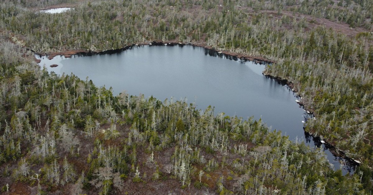
I'm sure lots of you would have had all kinds of guesses, but I am also sure none of you would have had "an island off the Eastern Shore" as your answer.
Here's the zoomed out version of the image I showed previously.
All the photos were taken on Wolfe's Island. #NovaScotia A lake and a pond surrounded by conifer forest, with ocean a
May 27, 2021 β€’ 12 tweets β€’ 5 min read
This is going to be controversial, but here goes.
Although I do believe in #GenderEquality, I don't consider myself to be a #feminist.
I will explain the reasons why in this thread... (1/x) First let's look at the Meriam-Webster definition of the word...

"[A] belief in and advocacy of the political, economic, and social equality of the sexes expressed especially through organized activity on behalf of women's rights and interests."

(2/x)
May 13, 2021 β€’ 7 tweets β€’ 4 min read
Alright: today's the day.
I'm going to use the #CanSIPS to try and figure out some of the puzzle pieces of the #HurricaneSeason, which starts in 14 days.
First thing to notice: NO El Nino. The equatorial Pacific is coolish, & the Atlantic is warm.
El Nino suppresses hurricanes.🧡 Next: there's lots of rising motion over the Indian Ocean (green colour) and sinking motion over the Eastern Pacific (red colour).
That leads to more robust tropical waves coming off Africa, which have a higher chance of developing into tropical cyclones.