, 373 tweets, 124 min read
My Authors
Read all threads
The most idiotic thing that you'll come across as India-China square off on LAC and Sikkim is pathetic, defeatist commentary from Indian 'think-tanks' and 'strategic experts'. They'll have you believe that China is going to win w/o firing a shot!
From 2008 onward, Chinese started pricking India so much that a even a naturally lethargic Indian establishment reacted by raising new -
1) 3+1 Mountain Divisions
2) 3 x Infantry/Mtn Brigade Groups
3) 2 x Armored Brigades
4) Rejigged one more infantry division for north.
+
+
- If anything, all this posturing by the Chinese will lead to further hardening of stand by India. And pumping of new resources against the Chinese across the board.
'China is upset'
- That is what news reports and think tank circuit will have us believe.
- Why?
- Because we've build new roads.
- Some even want us to suspend building new roads.
- I mean, seriously?
#GalwanValley
As I said earlier, don't fall for rumor mongers and those deliberately trying to undermine Indian interests:
To those claiming 3,000 or 5,000 Chinese troops have entered Indian areas across LAC - what proof do you have? Who has counted them? And how exactly so many troops squat themselves in areas across LAC at 3-4 sites? Where's the common sense here?
#GalwanValley #LadakhBorder
Brilliantly put. This is the bigger problem we're facing -
As per The Hindu, China not clarified LAC in Ladakh sector because -

"China has since rejected this exercise, viewing it as adding another complication to the on-going boundary negotiations"

Or may be, just may be, they don't want to do this because +
thehindu.com/news/national/…
+
ambiguity suits them. They can maximize their claim depending on the situation. Claim more tactically superior territory. Or, they can claim what is held by India and then, in negotiations, agree to give it up for tangible gains.
- Shows that we've an army chief who's acutely aware of the Chinese shenanigans.
- Having said that, author says that cutting through Galwan-Murgo axis can provide alternate to Karakoram Highway
- How?
- People don't consult map before writing such stuff?
m.hindustantimes.com/india-news/arm…
Some points -
(1) In my opinion, all the border mgmt related agreements which we've sighed over 30+ years with China, are irrelevant.
(2) Let me explain - China is a revisionist and an expansionist power. It is looking for world domination, starting +
#IndiaChinaBorderTension
+
with dominating Asia. India on the other hand is looking for status quo.
(3) For India, these agreements are stepping stone for final border resolution. For China? These are temporary measures to keep things calm in those regions which are not its priority at present
+
+
(4) Chinese make very little concession while getting the other side to yield major ground.
(5) Not only that, China throws tantrums from time-to-time to remind the other side that things are not settled or when it wants to send a message.
(6) By signing various border
+
+
management agreements with India, China could focus on its main rival - USA!
(7) Just map the massive naval build-up which the Chinese have done to secure their sea claims. All this was possible only if its borders with its biggest rival in Asia, India, remained calm.
+
+
(8) True, we also needed this quite period to focus on economy but unlike us, Chinese concentrated on building infrastructure for future.
(9) Chinese know they will settle the boundary dispute at their terms. And hence, they put in infra for a conflict which was to happen
+
+
15-20 years in future.
(10) But what did we do? Well, not much. We've instances of our Finance Ministry raising question mark on certain acquisitions saying that Chinese are unlikely to be a threat in future!
(11) But Chinese being Chinese, they couldn't stop themselves from
+
+
trying to show India its place. So, from 2008 onward, they started needling India and we had some major stand-offs in this decade.
(12) So much so that a lethargic institution like GOI, which generally lacks strategic vision, gave permission to Indian Army for a massive
+
+
increment in numbers.
(13) And Indian Army embarked on its biggest expansion after 1985, adding new formations from Daulat Beg Oldi to Arunachal Pradesh.
(14) Even today, as India and China square-off in eastern Ladakh, Chinese are sending three messages.
+
(15) Message 01 - that border is not settled and that Chinese can play spoil-sport as they want. I genuinely believe Chinese are not looking for a fight - they're looking for concessions.
(15.1) I think they will ask India to stop its infra and troop build-up. Why?
+
(15.2) Simply because even today Chinese are not ready to take-on India. For all their funky weapons and Sun-Tzu inspired fancy quotes, they lack the ratios required to defeat India. Period.
(15.3) With US breathing down their neck, and they now getting push-back in the Pacific
+
+
last thing they need is to take-on India.
(15.4) They need another 10 years minimum to take-on India, after having settled their Pacific question.
(15.5) So, they need peace on the Indian border and they need India to remain weak with respect to Infra and troops.
+
+
(16) Message 02 - This is quite straight forward - Chinese are facing hostility across the globe for how they've conducted themselves with respect to #COVID__19. Plus, they've a blow-hot, blow-cold relationship with US. In this situation, they don't want India to ally
+
+
against them.
- Indian Government allowing participation, even though online, of two of its lady parliamentarians, in the swearing-in ceremony of Taiwanese PM, is a big break from the past.
- GOI really really wanted to send across a very strong signal to the Chinese.
+
+
And the signal is very clear, two can play the game! Anything to do with Taiwan is a big red-line with the Chinese, so this act would've been seen a big red-flag by them.
- Rather than talk, the Han is using coercion to get India to fall in line.
- So much for Sun Tzu quotes!
+
(17) Message 03 - After being surprised in Doklam, Chinese had to send a message that they can get better of India in border dispute.
- This is separate from all out war.
- This is putting the other side in a such a situation where he's left with little to no maneuvering space
+
+
and has to agree to a reconciliation at other party's terms.
- This is what happened to the Chinese in Doklam. Their only option was to escalate full blow conflict or back-down.
- And they did back-down.
- Here again, Chinese would be expecting India to back-down and accept
+
+
fait-accompli.
- And as mentioned in Message 01, get some concessions also in the bargain.
- Don't be surprised if Chinese ask for a mechanism to regulate future infra development along the border.
- With themselves having developed their infra, guess who is at disadvantage
+
+
here?
- Yup! India.
- They can always play tantrum and raise objections at any of our project, claiming it violates the 'spirit' of some XYZ agreement.
------------------------
All said and done, we've in for a long haul here.
And one final, but very critical point:
- Chinese looses face if is not seen to have explicitly won here while India wins by simply standing its ground.
- If India is willing to go the whole hog here, Chinese are going to have a very nasty surprise.
- Simply because while the
+
+
Chinese have mobilized troops to match our immediate strength, but these are not sufficient for a shooting match.
- For that, Chinese need a much much larger mobilization.
- We're much better placed on this aspect.
- Chinese could get a quick drubbing here.
-----
Wait & Watch!
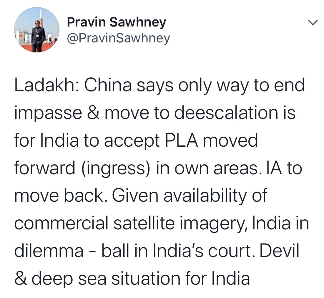
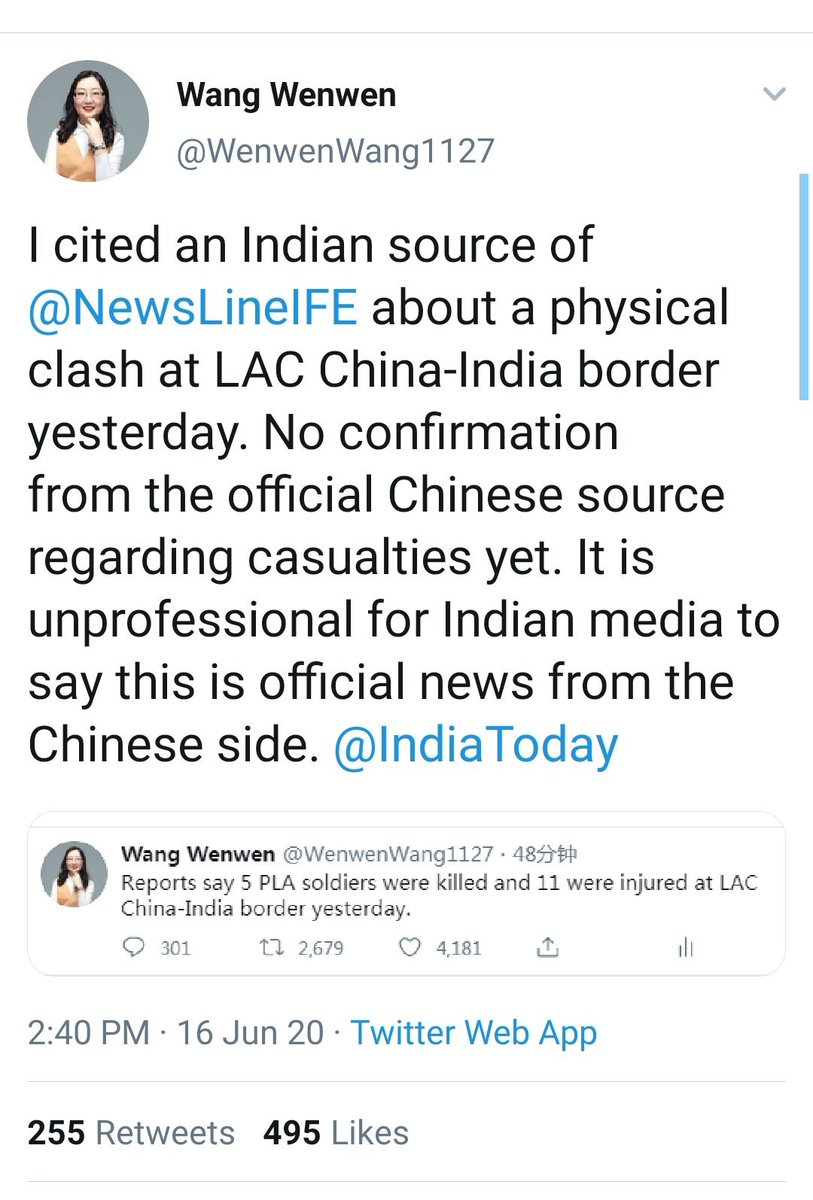
Please look at these 3-data points from three different outlets, all talking about the same incident. Now ask yourself, which is most likely scenario, who's being alarmist or peddling agenda.
@elmihiro @hukum2082 @Aryanwarlord @YusufDFI @ramana_brf @CestMoiz @desertfox61I Image
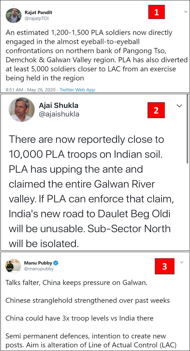
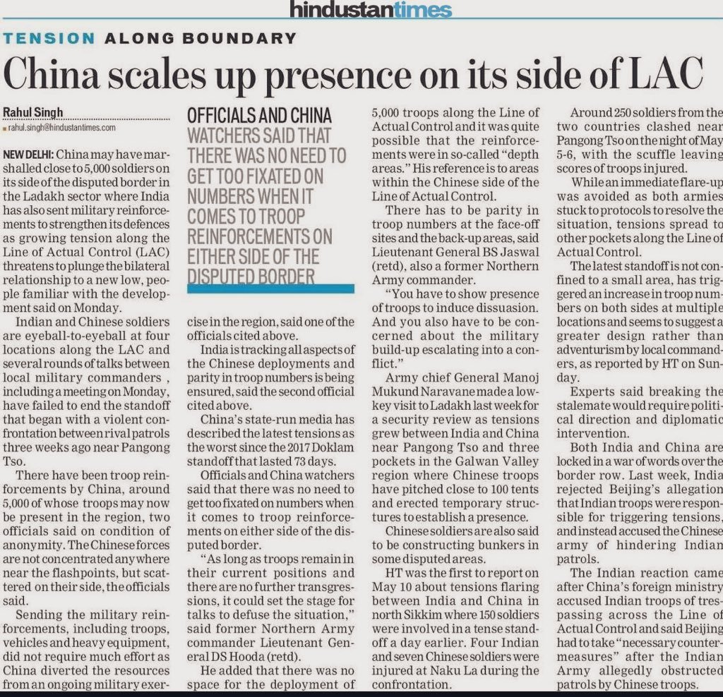
China has marshaled 5,000 troops most of which are on their side
- Finally, some sane commentary.
- Otherwise, some geniuses would have you believe that 10,000 Chinese troops are sitting inside INDIAN territory!
PS: Indian Army has >5 times this number always based in Ladakh. Image
A decent article by @jomalhotra on the ongoing India-China stand-off in Eastern Ladakh.
BUT
- Please understand, Karakorum Pass on India-China border has NOTHING to do with Karakorum Highway between Pakistan and China.
- See the attached map.
theprint.in/opinion/global… Image
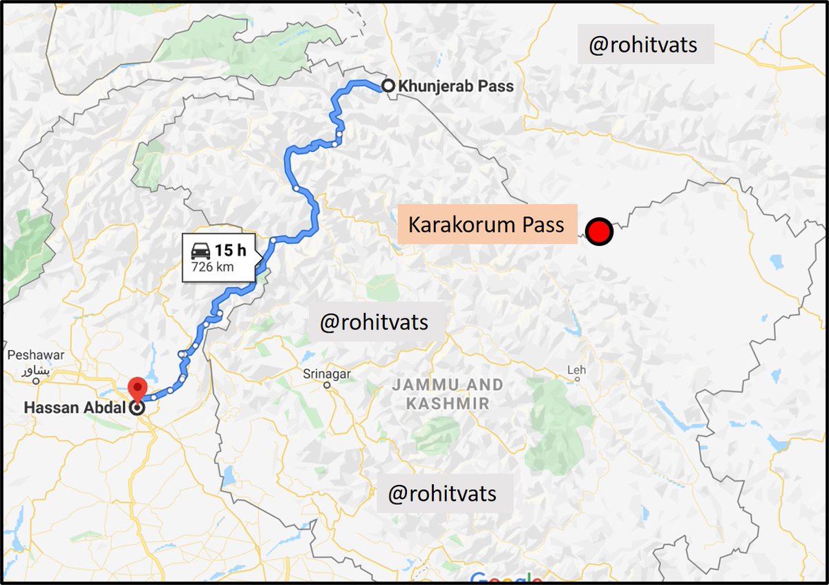
Karakorum Highway (blue line on the map in previous tweet) is named after the mountain range along with the Kunjerab Pass is located. Karakorum Pass (KK Pass) is also located along the same Karakorum Range but is >250 km east of Kunjerab pass, as the crow flies.
After wild assumptions, some clarity:

- No transgressions in the Galwan Valley
- ~3 km into Indian territory in the larger Hot Spring Area (Patrol Point 14, 15 and Gogra Post) and Fingers Area of Pangong Lake.
- 600-800 Chinese soldiers near each point

theprint.in/defence/india-…
And here's the way immediate way forward. What exactly were the Hans expecting?
As the good general sahab says, don't go by the empty sensational claims of some 'journalist' - Do read key points which he mentions:
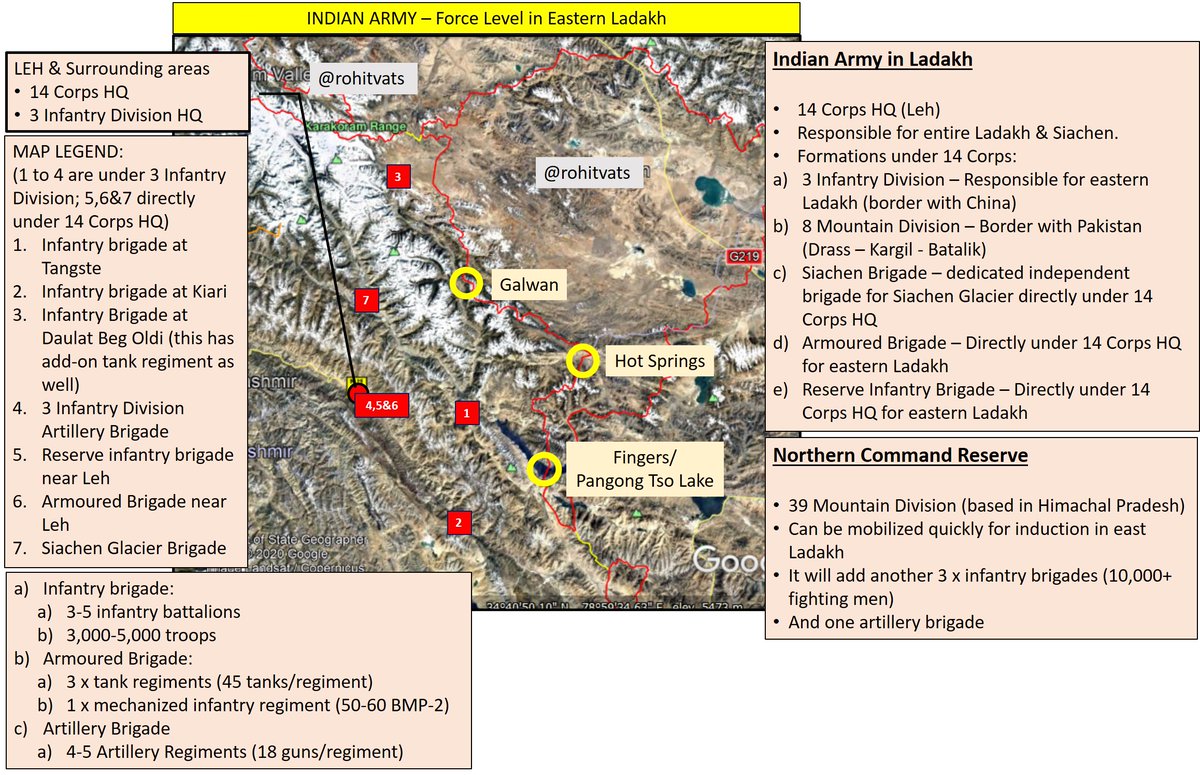
When we have such information being thrown about, its about time to discuss what Indian Army has in the Ladakh theater. Check the next tweet. Image
-Summary of Indian Army in Eastern Ladakh.
- 150+ tanks, 100+ BMP-2, 20,000+ troops, Artillery guns
- For brigades mentioned on the map, their attendant infantry battalions will be deployed up-front.
- All flash points covered.
- Additional reserves available at short-notice Image
"India firm, won’t step back from areas where Chinese troops have intruded"

- India makes its position clear.
- Openly names the Chinese.
- Basically, telling the Chinese that you've miscalculated big time.

Read more at:
timesofindia.indiatimes.com/articleshow/76…
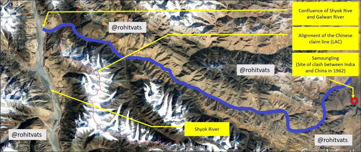
Some relevant maps which I had made earlier, when this stand-off had just been reported:
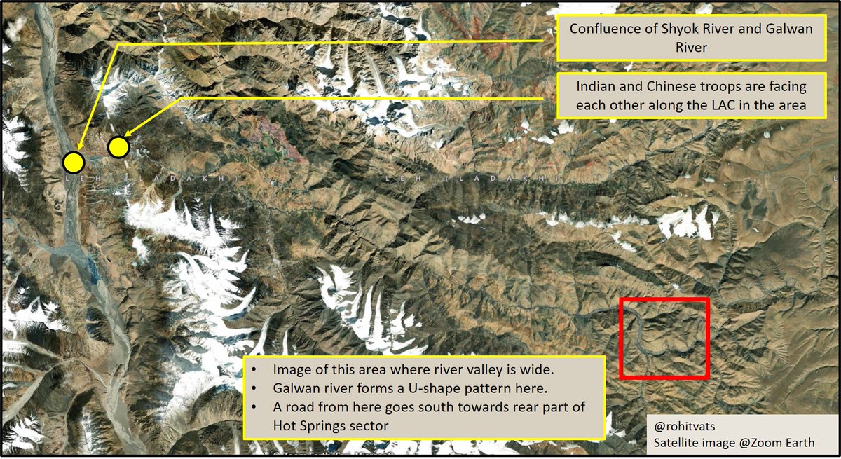
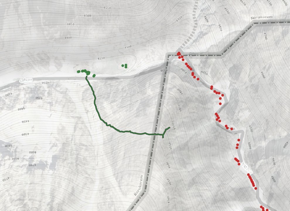
- Map 1: Important landmarks and area of current face-off (Galwan River)
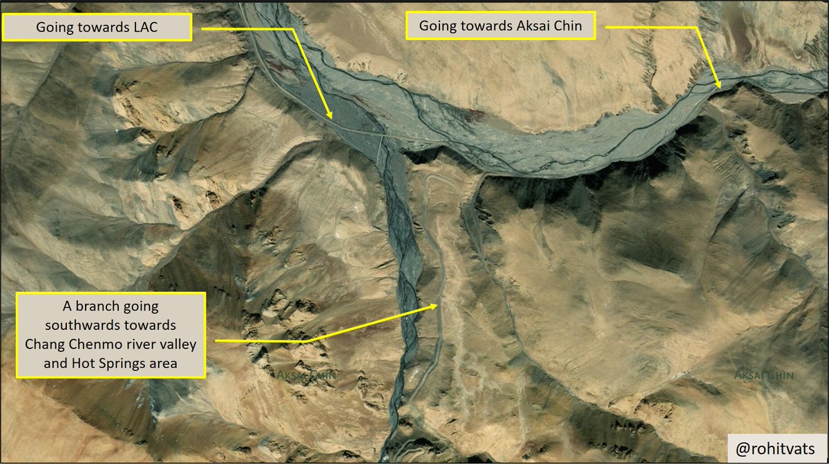
- Map 2: Galwan River (blue line) along with alignment of Line of Actual Control (as per Google Earth) in the region. ImageImage
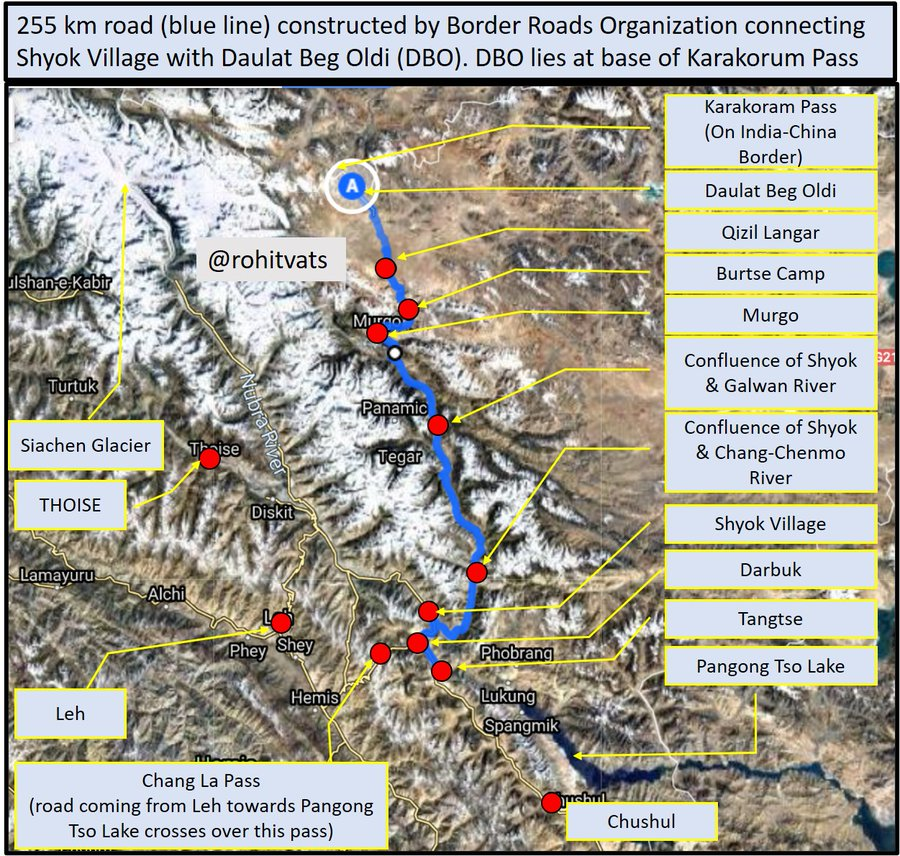
- Alignment of Darbuk - Daulat Beg Oldi (DBO) road which is causing pain to the Chinese.
- This 255 km road greatly improves our connectivity with DBO and allows movement of men and material. Image
An example of Chinese Army (People's Liberation Army-PLA) outpost in the area behind LAC.
Some third party confirmation of the ground situation along the recent flash-points. But since this does not confirm to 'invasion' theory peddled by some, it is likely to be considered as biased.
Whats the big deal about PLA deploying artillery guns or tanks or APCs now behind LAC? We've had these assets in Ladakh all this while. It only shows that PLA did not initially come prepared and is only now counter-mobilizing after Indian Army moved it assets forward.
NM initially tried to extend olive branch to Pakistanis. And reversed course only after repeated terrorist attacks by it. I think we're going to witness same here with China. This is a water-shed event. Expect a more hard-line stand against China.
#LadakhBorder #LadakhTension
Recent video of Indian Army (+ITBP?) soldiers giving some tough love to the Chinese has busted the myth and narrative of meek Indian soldiers & response to aggresive tactics of the Chinese.
We not only have to deal with the Chinese and their belligerent press but our own self proclaimed strategic experts as well.
(pic courtesy: @elmihiro ) Image
[Galwan River Valley]
- Series of videos courtesy @scorp18th which shows Indian-Chinese patrol engaging each other.
- This appears like the Galwan river valley; Chinese are coming from east, we're moving from west to east.
- Please focus on the terrain.
[Galwan River Valley]
(1) Look how steep the mountains are on each side, these are near vertical cliffs.
(2) There valley is very narrow; with water flowing in the middle, there is hardly any space on either side for troop movement.
(3) Notice the terrain. Loose large stones & gravel.
(4) Please ask yourself this - how could have 000's of Chinese troops come down this route, as some journalist want you to believe?
(5) And mind you, this part of Galwan River (see map in next tweet)
(6) is actually the widest.
(7) MAP -
- Galwan River valley is very narrow on the Chinese side. And it is like this for entire 40 km length through which Chinese have to come to reach this point.
- Can 000s of troops come down, and be sustained through this route? Image
An important observation - this is plausible because while moving up the Galwan river valley, Chinese troops would've had to cross the narrow stream to go from one bank to another searching for a suitable route. Again - 000s of troops through this route?
It seems with each passing day, Shook-Law is becoming more desperate. When no one bought his bogus story of 10,000 PLA soldiers having intruded inside India, he's back with mini-Kargil conspiracy theory. I will present counter-points to sensational claims raised by him.
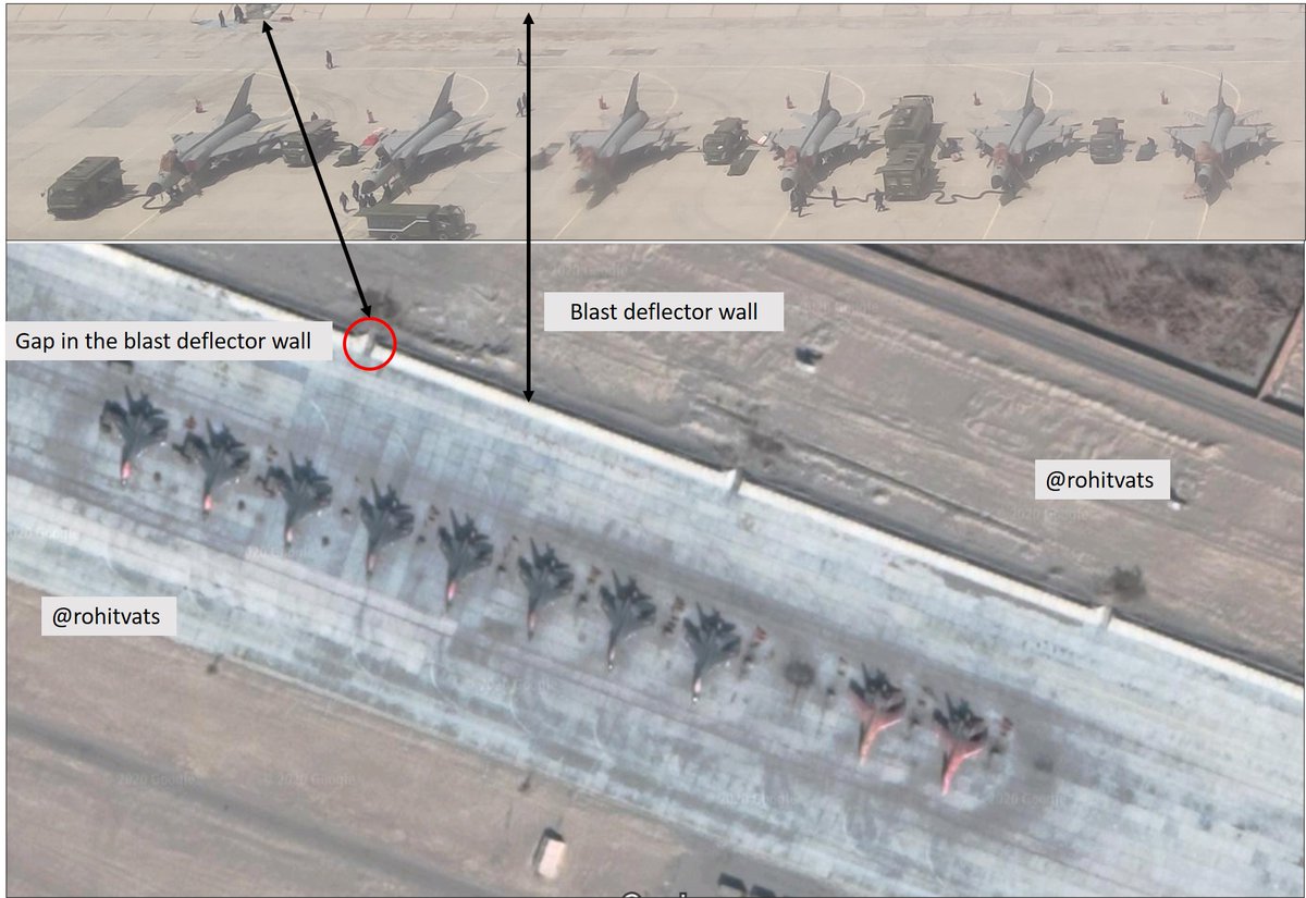
- Images show PLA Air Force concentration in some air base under Western Theater Command.
- Looking at the second pic with 6 J-8 and comparing it with satellite images, my opinion is that this is Hotan Air Base, ~380 km NE from Leh.
Image
- Indian Army has moved in troops worth two divisions into eastern Ladakh sector.
- I have said this before, we have more than enough resources to outmatch the Chinese.
- And if Chumar 2014 incident is any template, we aim to dominate in 2:1/3:1 ratio.
theprint.in/defence/northe…
Came across this funny scenario courtesy @VinodDX9 . Lets look at the absurdities here -
(1) Turned off vehicle lights to prevent detection by hostile drones - OK. This has to be the most funniest bit. Lights were switched-off but engines were running! Those vehicles would + Image
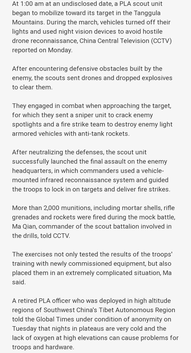
+
light-up like a Christmas tree on Infra-Red camera of an UAV like in the image below.
- So, surprise is lost!
- 'Enemy' will be firing at it even before it can reach anywhere near them.
(2) Using drones to drop explosives to tackle enemy defensive obstacles - Provided this + Image
+
genius PLA scouts unit is not obliterated before hand and some do reach perimeter of 'enemy' defensive position, how many drones can you launch and exactly what kind of defensive obstacles can they neutralize?
- Never mind that you've already given away surprise and 'enemy' +
+ is waiting for you.
- (3) Sniper/enemy search-light? - An enemy who potentially has UAV to search the area, will use search-light to illuminate its defenses? It won't have IR sensors or battlefield surveillance radars?
- this whole exercise is like a bad Hollywood movie!
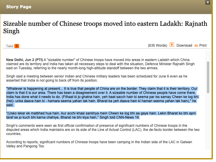
What RM said (from: @DevirupaM )

- '...seema par iss samay Cheen ke log bhi hai'..
[There are Chinese soldiers AT the border. Not WITHIN Indian borders or claim line]
-'..aur acchi khasi sankhya mein Cheen ke log bhi aa gaye hain'.
[There are considerable no of Chinese troops] Image
Everything you wanted to know about the Pangong Tso/Fingers Area. @nitingokhale in conversation with @sdinny14 (Colonel S Dinny - he commanded an infantry battalion in this very area). This conversation will clear all your doubts. Do watch and share.
[1962 War History and Current Situation]
- Historical context to alignment of Chinese claim line in Pangong Tso region. And why Indian LAC claim in Fingers Area is different.
- Key is Sirijap Complex: Chinese advanced till Sirijap and captured Indian positions there in 1962
+ ImageImage
+
- Therefore, it is logical to assume that LAC should run along Finger 8 because Chinese forces stood to its east in 1962.
- By advancing LAC till F4, Chinese want to give more depth to their position in Sirijap complex.
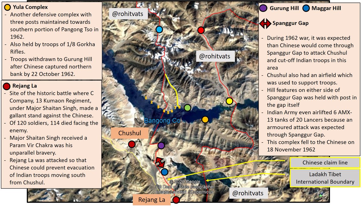
- Alignment of Chinese claim line from Rejang La to
+
+
Ane La is in such a fashion that Chinese control all the mountain passes and mountain ridges to ensure India cannot (or, it is very difficult to) attack from west to east.
- (Fingers have been numbered as per map shared by @sdinny14 during his conversation with @nitingokhale.
Historical images -
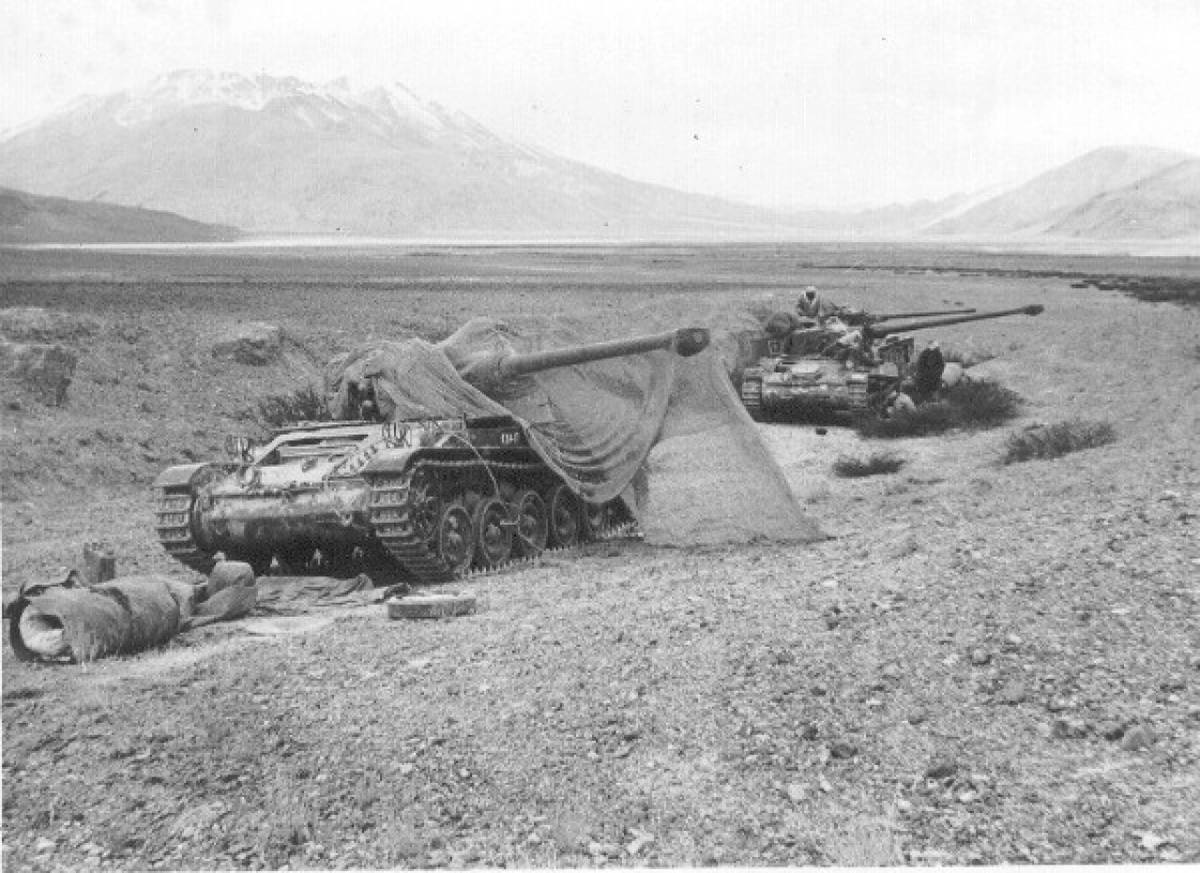
1) AMX-13 tanks, 20 Lancers, defense of Spanngur Gap.
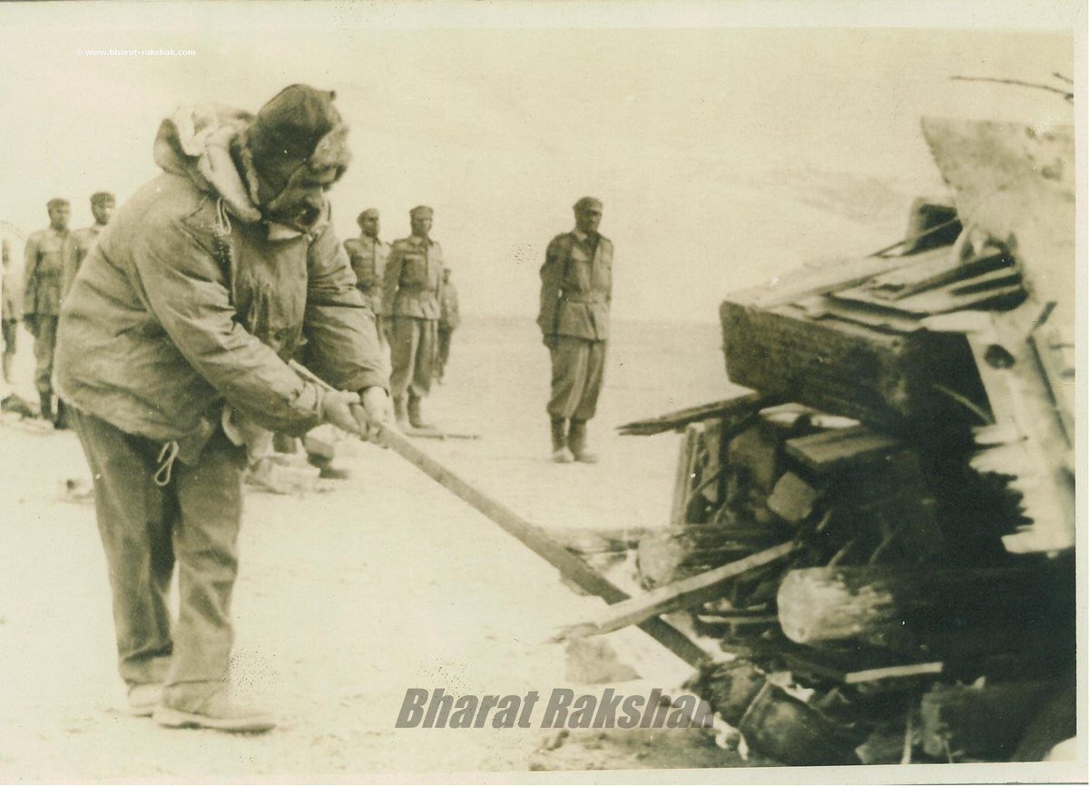
2) Brig TN Raina, MVC, Commander 114 Infantry Brigade lighting the mass funeral pyre
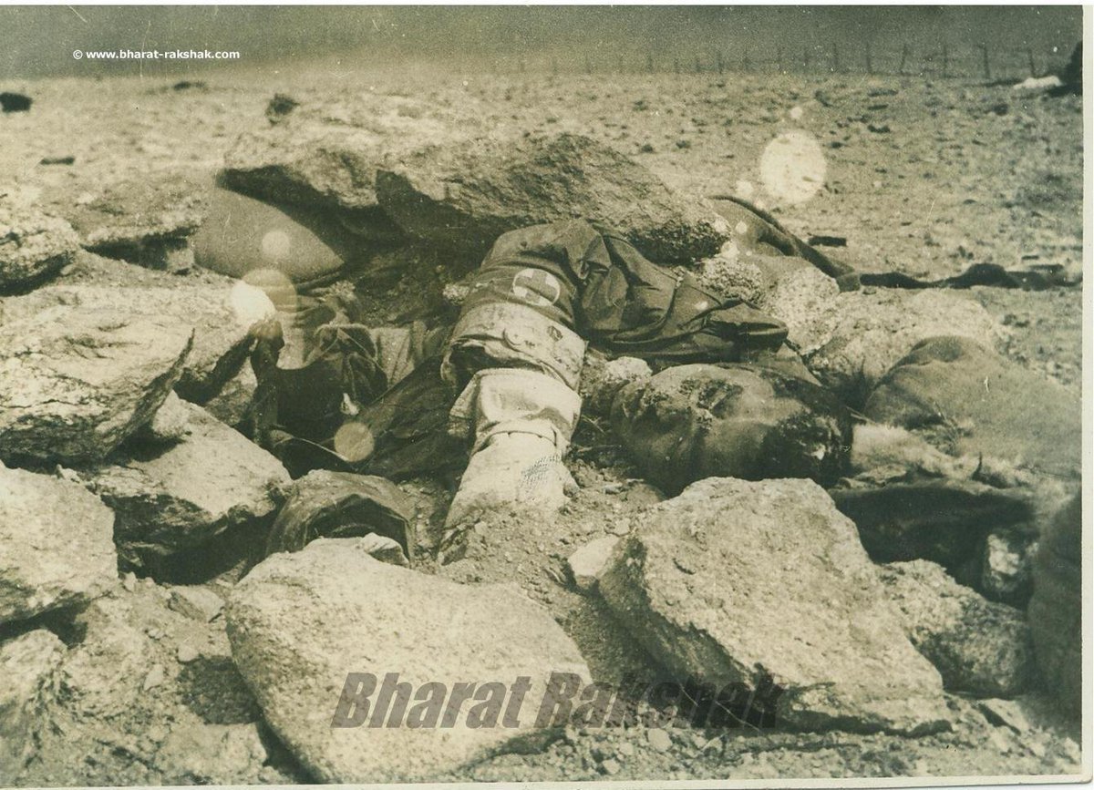
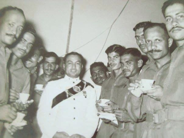
3) Maj Dhan Singh Thapa, PVC
4) Body of Nursing Assistant Dharam Pal Singh Dhaiya who died nursing wounded at Rezang La ImageImageImageImage
1) Two Jawans who fought side by side and died side by side at Rezang La
2) Funeral pyre of the jawans from battle of Rezang La
3) Maj Shaitan Singh, PVC (posthumous)
4) Rezang La battle memorial ImageImageImageImage
Update on the recent developments and status along Pangong Tso and Galwan flash-points. Please read the whole thread.
Interview of General VP Malik @Vedmalik1 on the India China stand-off in Eastern Ladakh. Do read.

Detailed discussion on the Galwan River Valley flash-point by @nitingokhale . Please do watch -
"If the Chinese are able to cut us off at Daulat Beg Oldie, they can put pressure through axis Murgo-Saser La-Sansoma".
-That's an idiotic statement!
-Check the map for alignment being talked about.
-I explain in follow-on tweets why this is nonsense
+
hindustantimes.com/india-news/ahe… Image
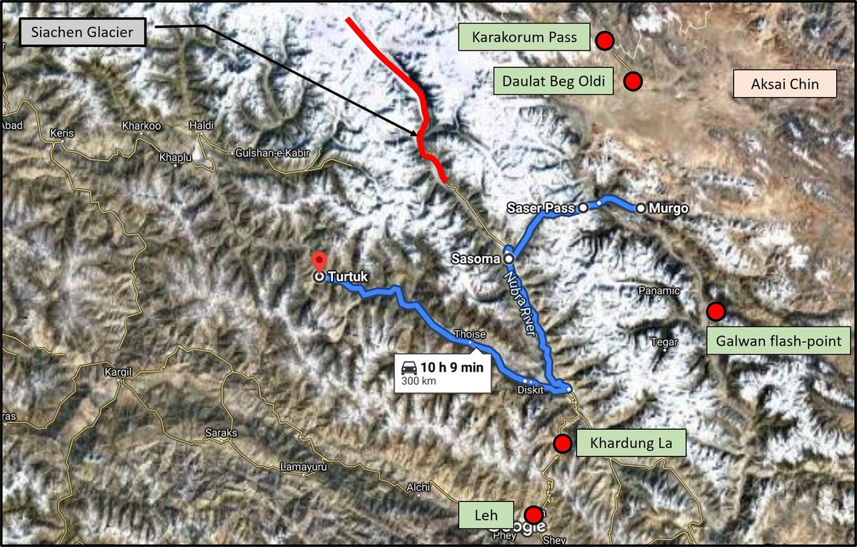
+
- For China to connect with Pakistan through this axis would mean going west from Murgo, crossing Shyok River, crossing the 17,752 feet high Saser La pass, and then going down towards Sasoma (which is ~50 Km from Siachen Base Camp)
- Then it has to reach Diskit near confluence+
+
of Nubra and Shyok River.
- From there, it goes west to THOISE and then along the Shyok River, reaches Turtuk (last point in India along LOC in this sector).
- If anything like this were to happen, it would mean we've lost Siachen Glacier and the entire Nubra and Shyok Valley
+
+
including THOISE and all villages along the river as it flows into Pakistan.
- If it ever comes to this situation, it would mean India has been defeated at such a scale that 1962 will appear benign!
- Oh! and BTW, Border Road Organization (BRO) is actually working on creating
+
+
- a road going from Sasoma towards Saser La Pass and thence, going down the other side of the mountain, reaching Shyok River, crossing from west to east bank and then, reaching Murgo.
-From Murgo, route goes to DBO and Karakorum Pass.
- As of 2016-17, BRO had constructed
+
+
a 52 km road from Sasoma to Saser La road.
- Road from the pass towards Murgo is WIP.
- When this road is ready, India will have an alternate route to new Shyok-DBO Road.
- Always good to have alternates in a shooting match!
- Here is some bit of history for you -
+
+
-- Summer route for caravans traveling from Leh to Yarkand in Xinjiang was Leh->Khardung La Pass ->Sasoma->Saser La->Murgo->DBO-> Karakorum Pass.
-- Winter Route: Leh -> Chang La pass - > Shyok Village->move on/along frozen Shyok River-Murgo->DBO->Karakorum Pass.
[Bursting Chinese Propaganda]
- Typical Chinese propaganda of super efficient Chinese soldiers and PLA!
- Tragedy is, many buy into such propaganda as well.
- Time to burst this bubble:
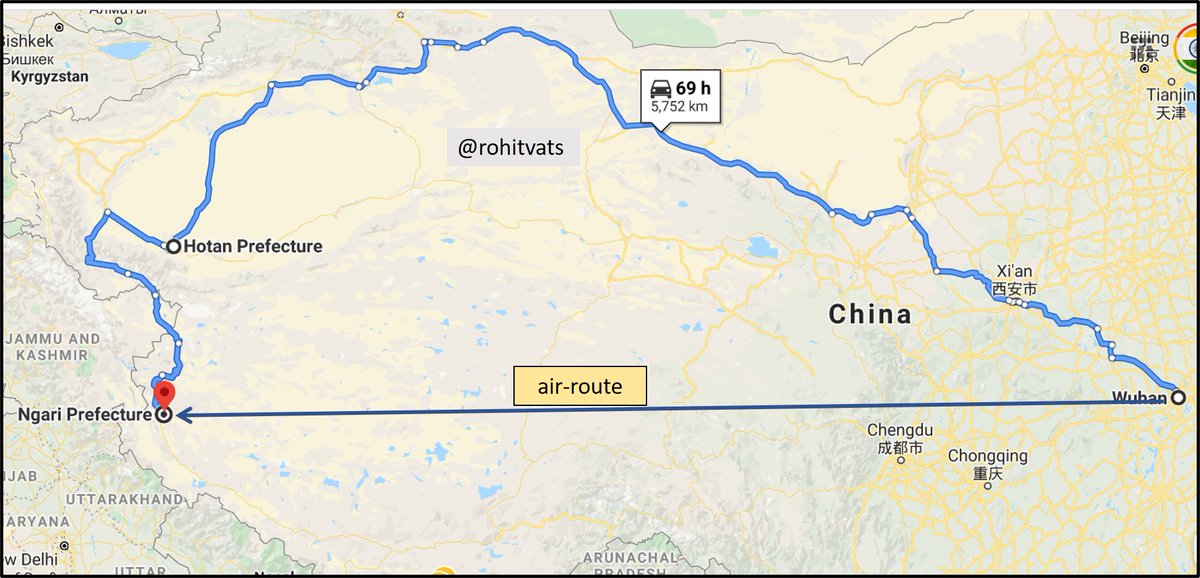
(1) Chinese 15 Airborne Corps is based in northern part of their+
+
Hubei province whose capital is Wuhan!
(2) From Hubei, troops and mechanized assets have to move to an area opposite Aksai China.
(3) Air distance - ~3,200 km (Ngari Airport) / Road & distance - ~5,800 km (assuming road & rail distance is same)
- Please see the map below. Image
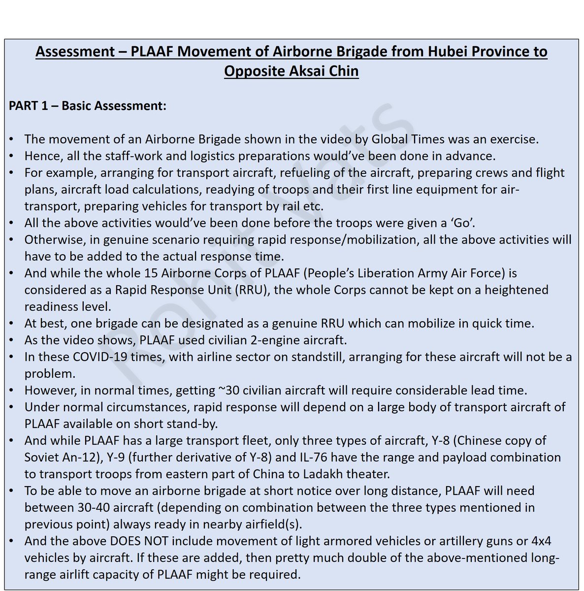
PART 1 - Basic Assessment.
(1) Chinese are passing off a normal military exercise, planned in advance, involving one of their airborne brigade(s), as some sort of rapid response to current stand-off.
- See Part-1 of detailed assessment below: Image
Part 2 - Assumptions taken for analysis.
- Basic assumptions taken to analyse the troop movement as mentioned in Global Times.
- But does China have airport capacity near Ladakh to handle these troops? Please check follow-on tweet(s).
+ Image
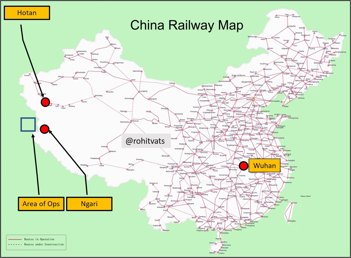
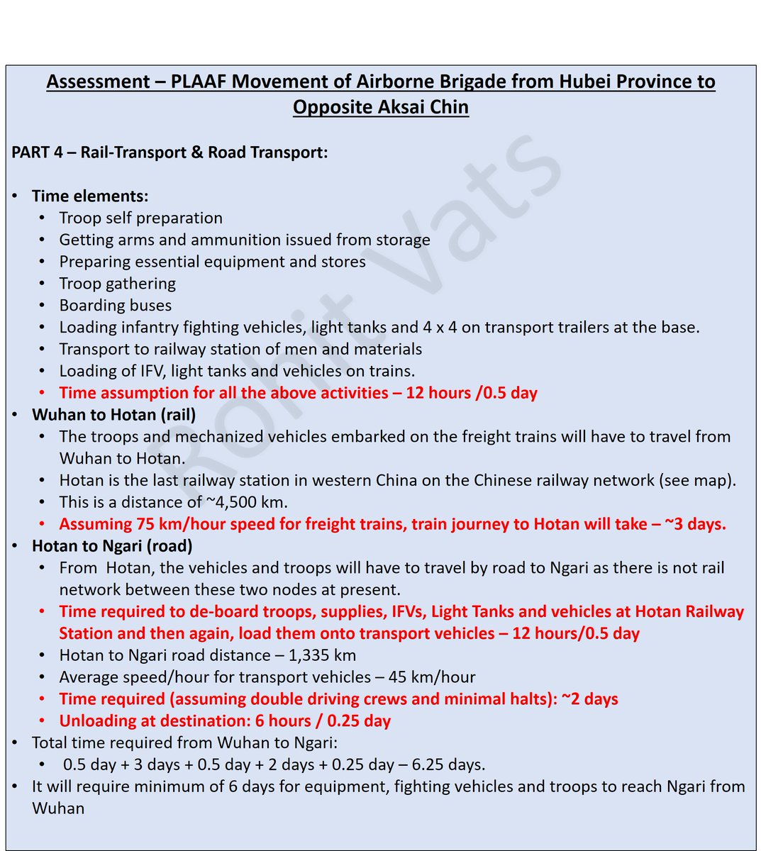
Part 3+4: Travel time required by air, rail and road.
- By air: 11-12 hrs to reach Ngari airport (70% troops)
- Rail (Wuhan to Hotan) - 4 days [30% troops plus IFV, light tanks & vehicles]
- Road (Hotan to Ngari): 2.5 days. [ Hotan is last railway node] [ Total: 6.5 days] ImageImageImage
Part 5 - Ngari Airport - Bottleneck!
- It has ONE runway of 10,000+ feet length.
- Entrance to parking area is in middle of the runway length.
- On landing, a transport a/c will have to travel till opposite end, turn around, travel back half distance and then, enter parking area. Image
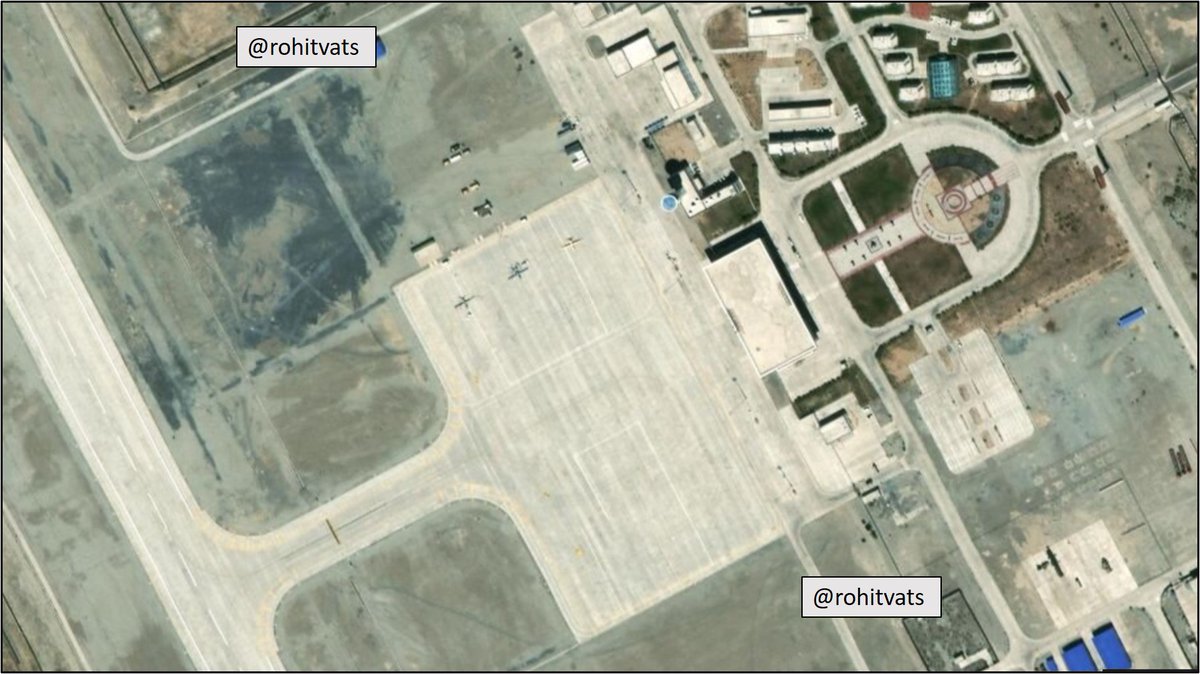
Parking Space:
- Satellite image (Sep 2019) below shows 3 x UAV parked on northern side of the apron.
- This side can at best accommodate 4 x A-320 size a/c.
- Similarly, assume 4 a/c on opposite side.
- Prima facie, the airport can at a time hold at max 8 A-320 sized passenger
+ Image
+
aircraft (of the type in which Chinese troops are seen traveling in the Global Times video).
- But as our calculation shows, PLAAF will need about 20 a/c minimum to transport 70% of airborne brigade troops by air.
- Coupled with additional time required for an a/c to enter +
+
parking space/apron (because of single runway as explained earlier) and limited parking space within apron itself, the balance 12 a/c will have to spend considerable time in the air till first wave of 8 a/c are able to off-load their troops+cargo, turn-around, go to start of
+
+
runway and then take-off.
- This will have to be a sequential process as there is only one runway with added handicap of apron entrance being in the middle.
- All this will add time to transport the airborne brigade.
- To the 11-12 hours required from 'GO' to reach airspace
+
+
above this airport, you can easily add couple of more hours.
- Other options is for the airborne troops to land at Hotan airport. It has the required infra to host 20 a/c transporting the airborne brigade.
- BUT - if troops land at this airport, they will need ~ 2 days
+
+
to reach operational area opposite Aksai Chin.
- Long story short, there is NO way in which the Chinese/PLAAF can transport a full airborne brigade, with its compliments of infantry fighting vehicles, light tanks and other assets in a 'matter of hour' opposite Aksai Chin.
END
Just to add one critical point to the above analysis-
(1) Elevation above sea level (Wuhan area) - ~100 feet
(2) Avg Ladakh elevation - 14,000 feet.
- Time required for acclimatization to effectively work and operate and fight at this altitude - 3 WEEKS!
Very interesting observation - Chinese soldiers traveling by chair car on a 4+ days of train journey 😆....this whole propaganda is going from bad to worse.
Shots fired... Government making its intentions known to the general public. Not to mention the Chinese will take notice. I guess the same message, given in a more softer manner by Rajnath Singh has not been registered.
- Finally, someone mentions the road being attempted from Sasoma to Saser La pass and thence, across Shyok to Murgo and then to Daulat Beg Oldi and Karakorum Pass
- In subsequent tweets, lets take a look at these roads and why they are important.
hindustantimes.com/india-news/ind…
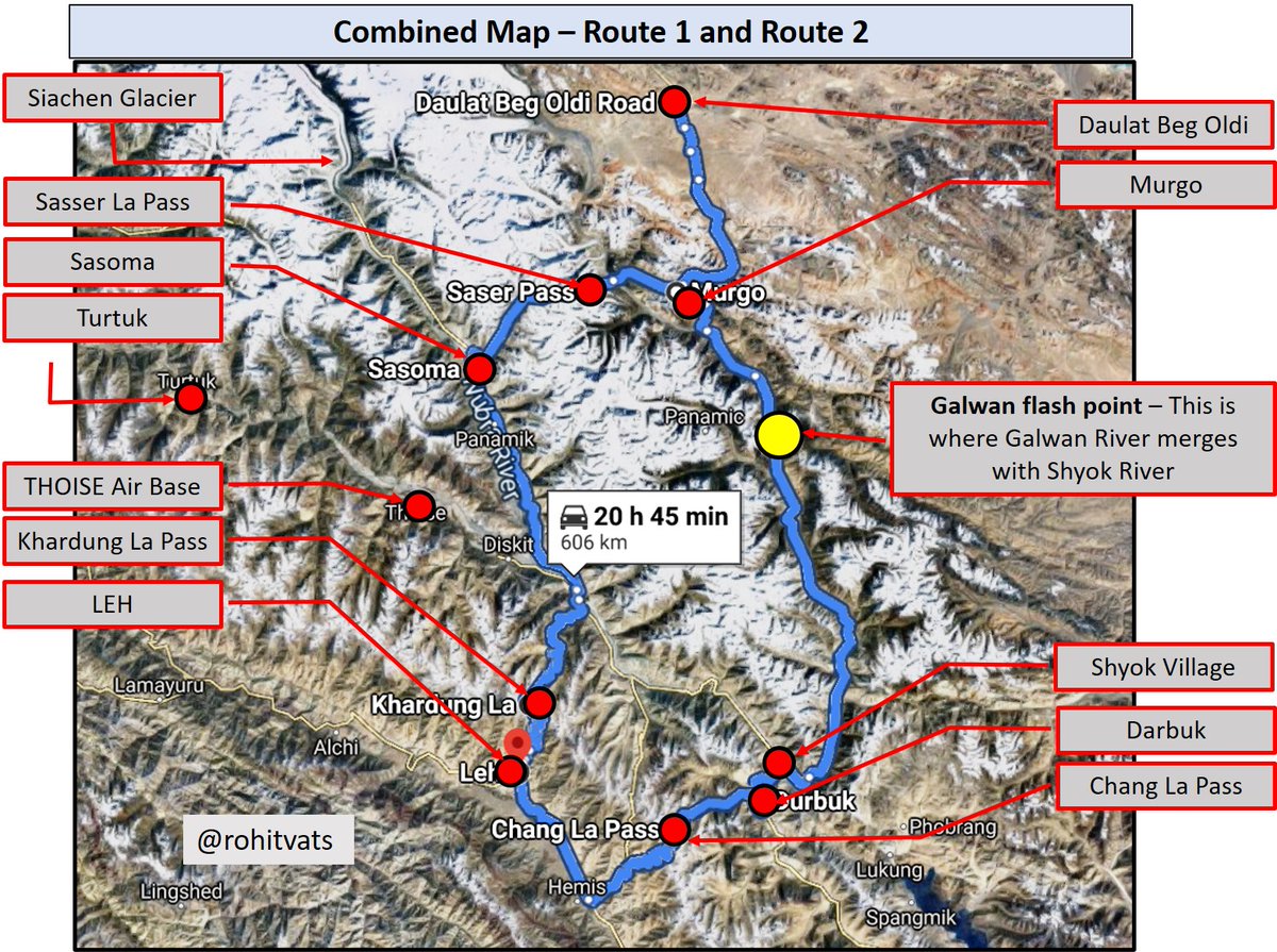
Route 1
- New road from Darbuk to DBO
- From Leh, you cross Chang La pass (17,590 feet), reach Darbuk and then to Shyok Village.
- From here, road is mainly along left/west bank of Shyok River
- Before Murgo, road goes from left to right bank, enters a gorge and reaches Murgo. Image
Route 2
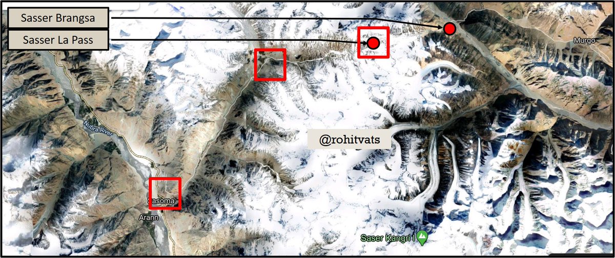
- Leh, Khardung La pass, go up along the Nubra River, reach Sasoma and from here, ascend towards Sasser La Pass.
- From Sasser La, go down towards Saser Brangsa (on left bank of Shyok River), cross Shyok river, each Chongtash (not marked on the map), the Murgo. Image
Combined Map - Showing the relative alignment of both the roads.
- Route 1 used to be followed by caravans going towards Yarkand in winters when Shyok river was frozen.
- Route 2 was used in summer because it was very dangerous to criss-cross Shyok River in summers when river + Image
+
was full of fast flowing water. Men and animals drowned while trying to cross Shyok river in summer.
- River of death - This is the reason Shyok is called as Shyok!
- But Sasser La pass was no less dangerous and took a toll on men and animals
+
[Present Status of Route 2]
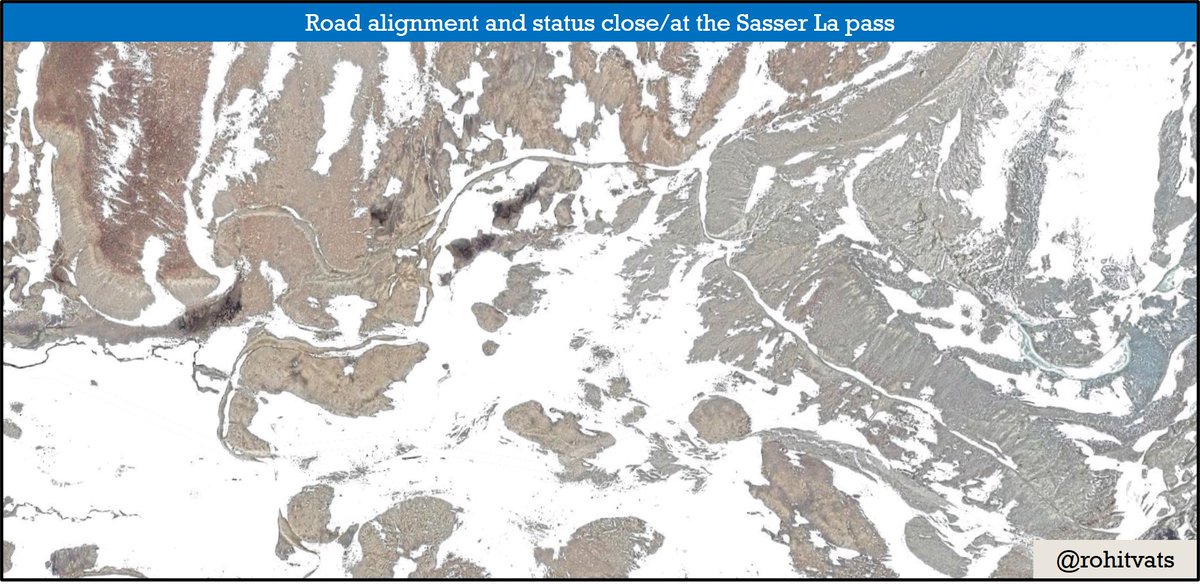
- As per news reports, as of 2018, a road has been constructed from Sasoma till Sasser La pass which is under further development.
- The next challenge will be extend the road from Sasser La pass to Saser Brangsa on left bank of Shyok River and then+
+
connect it to Murgo via Chongtash. And then onto DBO.
- 2016 Google Earth satellite images show the status of the road. ImageImageImageImage
View from the pass towards east; Shyok River can be seen at the base while the gorge beyond that leads to Chongtash and Murgo, thence to DBO. Image
One good side-effect of the on-going India-China stand-off will be that all SOPs for mobilization of troops and materials will be tested. Issues identified and rectified. Its a good dry run.
Games, which the Chinese play -
thehindu.com/news/national/…
I was on @IndiaToday to give a background and geographical details of the Galwan River sector. I collaborated with them to put together the maps in the program. Please have a look (8 minutes onward)-
A detailed article about the geography, history and present scenario with respect to Galwan Sector on @IndiaToday. PLease have a look and share your feedback:
indiatoday.in/india/story/in…
Even as India contemplates the next course of action after the tragic loss of lives at Galwan Valley, accept some to use it to further peddle their agenda. My request to you is please don't fall for that nonsense. Trust your army and trust your government.
#GalwanValley
+
As for what happens next, honestly don't know. But what is for sure is that GOI has lost maneuvering space here. Blood has been spilled and people will demand blood for blood. On a larger geopolitical scale, how we react now, will have long term consequences +
#GalwanValley
+
The world will be keenly watching our response. Chinese are the aggressors here and if they're allowed to go w/o VISIBLE retribution from Indian side, in my opinion, it will dent Indian reputation. In 1962, Chinese launched a full scale war to 'show India its place' and if +
+
this goes unanswered, I'm afraid we'll have a repeat of the same situation. At no cost to the Chinese. One of the reasons for Chinese attacking Vietnam was to showcase to the world that USSR cannot come to the aid of its allies (Vietnam+ USSR had a treaty)
#GalwanValley
+
If India cannot safeguard is interests, how will it become net safety provider to other countries? Also, the strongman image of Narendra Modi will forever become dented. Let there be no doubts about it. China has relied on Indian reluctance to escalate to get away +
#Galwan
+
with such transgressions. About time we used their playbook against them. Lets see if the Chinese are willing to escalate? Chinese will have to literally bring their whole bloody army to take on India. Are they ready for it? We've such entered into an uncharted territory +
+
here. The Narendra Modi government has just been served its biggest security challenge. How they respond, might well decide the trajectory of India on the global stage.
#Galwan
One indication of how this goes will be how the Chinese react and portray this incidence. They've for sure suffered casualties. Let's see if they officially accept these casualties. Chinese will either use their casualties to build-up rhetoric or say - 'both sides have +
+ suffered casualties, and both sides should sit down and talk'. If its the latter, expect more calls for talks. In case of Doklam, Chinese were allowed a face saving exit. In this case, only way NM government can be seen as having done something is if there is visible +
+
genuine concession from the Chinese. And I don't know if the Chinese will be willing to do that.
This is the statement from Indian side -
source: @ShivAroor Image
Words from the other side; this gentleman is the Editor-in-Chief of Global Times and the lady is a Chief Reporter there.
Pic-1 source: @ShivAroor Pic-2 Source: @defenceglobe ImageImage
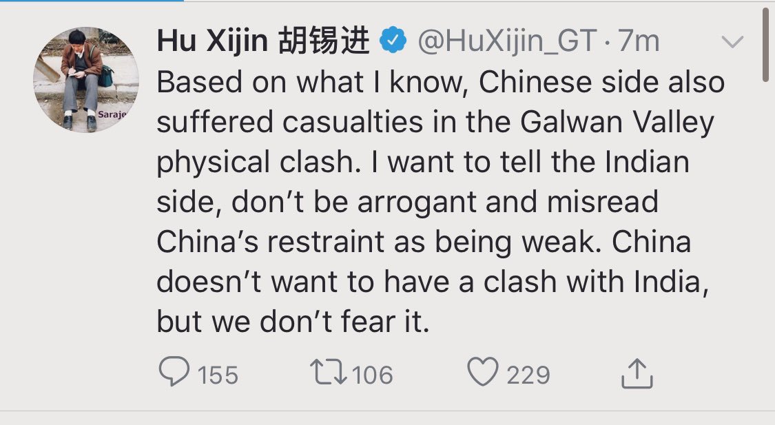
As the news of more casualties come-in, people's stand with harden. And political space will shrink. This incident along the ice cold water of Galwan river might be our very own Franz Ferdinand moment!
As expected, the Chinese have painted India as aggressor. This news was published at 1612 hours, Beijing time. So, that makes its roughly 1342 hours, IST.
globaltimes.cn/content/119177…
OK. So the Chinese have decided to play hard-ball here. Now all eyes will be on how the GOI reacts.
The million dollar question at this stage is this - how did the CO of the unit become part of this fracas?
This is a serious development. But need to wait for official word from the Army or MOD on this.
[What next?]
- Facade of peaceful LAC stands shattered today.
- If count of fatal casualties rising to 20, the whole paradigm of LAC management stands shattered.
- We cannot keep on loosing soldiers or them suffering grievous injuries in such brawls. What is the point of a
+
+
'peaceful' LAC and 'no shots being fired' if the soldiers continue to die or suffer debilitating injuries?
- What next?
- First, be ready for a short, sharp skirmish at the LAC.
- Act. Don't react.
- Shift the onus of escalation on the Chinese; whole Chinese strategy of such +
+
aggressive behavior rests on India not escalating. And that's what we've done since mid-80s.
- Go and sit across LAC on the Chinese side. As it is, the land is ours and occupied by China.
- For example, alter the LAC at locations where it is close to DS-DBO Road.
+
+
- Push LAC eastward in other sectors. There are vast open spaces in Aksai Chin. Draw a new Line-of-ACTUAL-Control.
- Use your advantage in numbers; Chinese simply don't have enough troops to counter India at all places.
- From Arunachal to Ladakh, China has managed to hold
+
+
against India with 1/10 the forces as compared to Indian commitment.
- Why?
- Because as an expansionist power, it knows it will fire the first round. And India in its desire to accommodate them, will keep on reacting and adhering to various border management agreements.
+
+
- In the meanwhile, the Chinese violate accepted boundaries and even LAC at will.
- They attack our troops and kill/injure them.
- This is how bullies behave.
- Only way to handle a bully is to hit back. And hit hard.
- Let the Chinese react to Indian aggression.
+
+
- What will they do?
- Bring more troops along the border? Well, good. Why? Because all this while, our troops were sitting on the border, Chinese troops were sitting comfortably in large cities 500 to 000s of km away.
- Make China commit those troops.
+
+
- You know how it screws them?
- Chinese have massively downsized its army. It hopes to use this army as per requirement. So, troops sitting in Chinese cities outside of Tibet will be moved against India or used in other theaters as well.
- Well, if they commit them to +
+ Indian border, they won't be available for other theaters.
- Second, it involves cost. Big money to maintain a large body of troops in a theater like Tibet.
- We as it is are sitting there.
- At least the full spectrum of Chinese threat will reveal itself.
+
+
- We won't be lulled into modern version of Hindi-Chini Bhai Bhai.
- Now, coming back to border - Will China be ready to go to war? Knowing that it will need to move most of its army against India to have any hope of successful outcome.
- If we've an economy to care for, so +
+ do they?
- Remember, India wins by not loosing and China looses by not winning. That is the curse for being a supposedly bigger power.
- And any loss of face will be a deathly blow to the Chinese reputation.
+
+
- But there is going to another fall-out of Monday night's clash - there will be very high level of suspicion between troops on both sides. Indians for sure.
- Any future stand-off can quickly degenerate into actual fire-fights.
- We've to be ready for this and ensure that +
+
Indian soldiers don't react. If the situation demands, let Indian soldiers be the first one to fire.
- Tell the Chinese that if they come within 2 km of our LAC, we reserve the right to fire. Simple.
- So, about time we change the rules of engagement.
+
+
About time the Dragon experiences what happens, when an Elephant looses its cool.
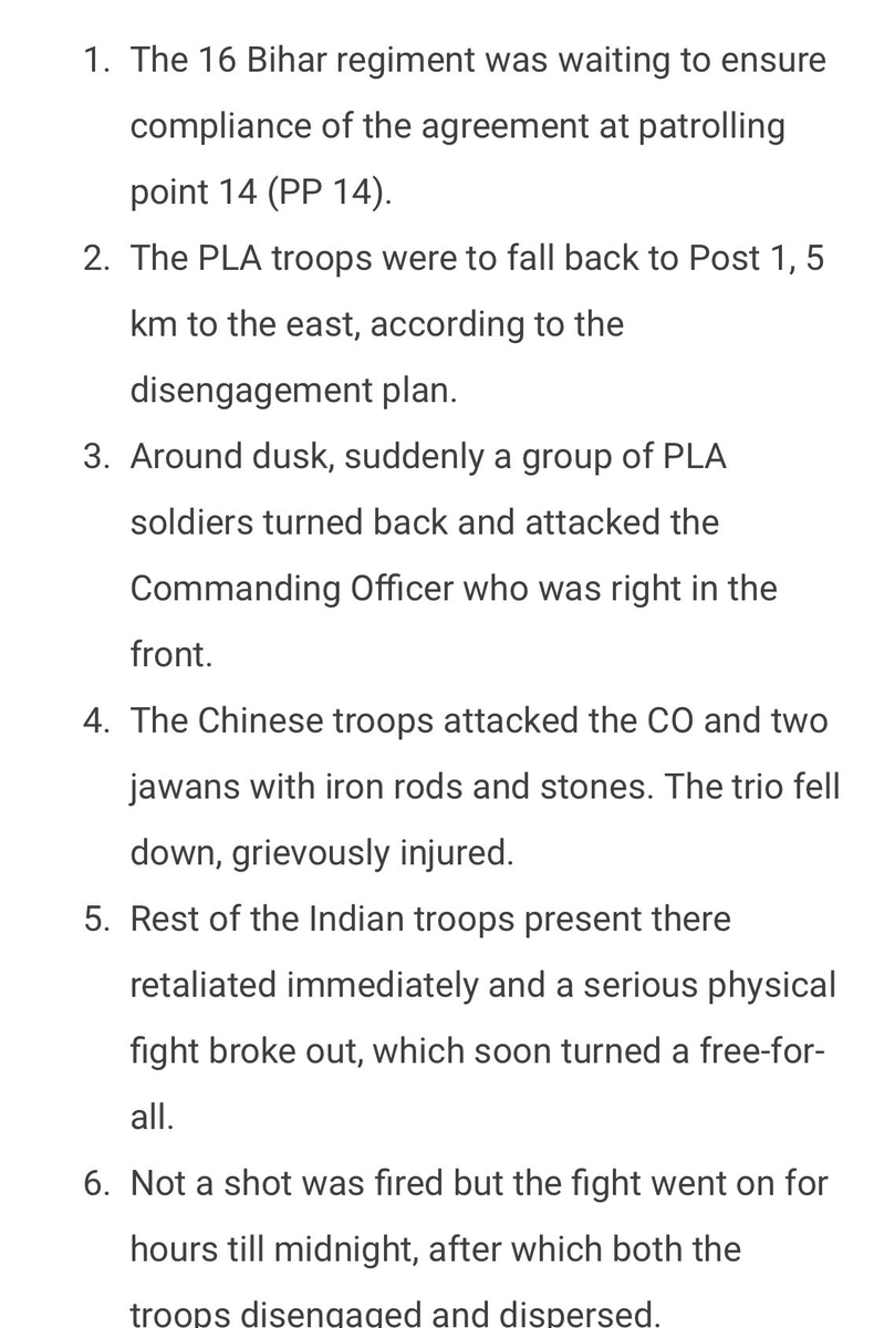
Official Indian Army statement on Galwan stand-off:
Watch out! The possibility of higher Chinese casualties as compared to India is not going to go well with some quarters. For them, it gives GOI some face saving; otherwise, they were all set to paint the town red calling government this and that.
Sequence of events at Galwan by @nitingokhale Image
Remember this -
- Pulwama became a catalyst for Balakot because of large number of casualties from across India.
- Similar thing will happen with 20 shaheeds of 16 Bihar. The whole nation will see their last rites.
- Emotions will run high; GOI will not have maneuvering space.
During Chinese intrusion into Depsang Plains in 2013, someone wrote these measured pieces. No sensational talk of 'Indian needs to throw out the Chinese' or 'another Kargil'. BTW, Indian Army had to destroy some infra in Chumar sector as quid pro quo.
ajaishukla.blogspot.com/2013/04/the-ro…
Another one -
Read both the pieces with context to present stand-off and guess what has changed?
ajaishukla.blogspot.com/2013/04/chinas…
Another source with potential chain of events -
Chinese Foreign Ministry is repeatedly sending out the same message. It seems they know shit has hit the fan.
I guess this statement puts to rest rumors about Indian soldiers in custody of the PLA -
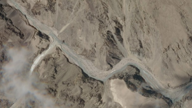
I've maintained this all along : In case of a shooting match, Chinese build-up in Galwan Valley will be butchered. Look at the satellite image below -
Do these troops or tents or vehicles have any place to hide?
Image @IndiaToday Image
Life and times of the man after whom Galwan river is named. Do read.
economictimes.indiatimes.com/news/politics-…
OK. Now the yellow matter has actually gone into the stratosphere. This is quite unprecedented.
I told you, Modi's speech was unprecedented. He's made his intentions clear. Abhi picture baaki hai -
Chinese Foreign Ministry on the above mentioned phone discussion. ImageImage
Prime Minister's speech - ImageImage
[What if - ]
- What if the Chinese suddenly break-out from their positions on their side of LAC in Galwan Valley and make a dash for DS_DBO Road at confluence of Galwan and Shyok River?
And here @Iyervval analyses who's where with respect to LAC in the Galwan Sector -
A sober account of what happened at Galwan river -
hindustantimes.com/cities/galwan-…
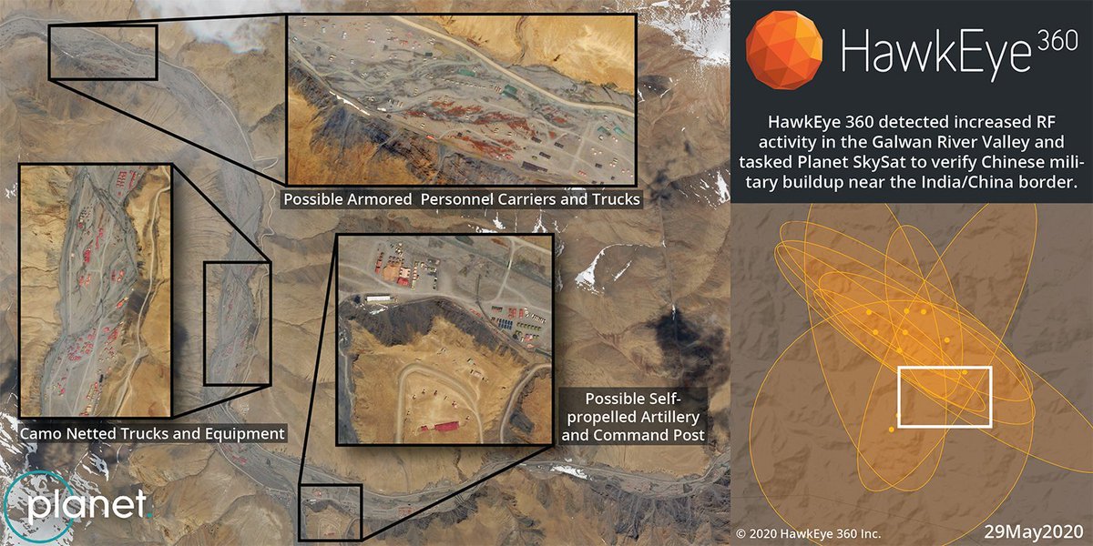
(1) 29 May 2020 sat image of upper reaches of Galwan river valley by @hawkeye360 showing Chinese build-up.
(2) Exact location of this build-up
(3) Close-up of the area showing Chinese road alignment here. ImageImageImage
Relevant to present times -

द्वन्द कहाँ तक पाला जाए, युद्ध कहाँ तक टाला जाए | तू वंशज है महाराणा का, चल फेंक जहाँ तक भाला जाए ||
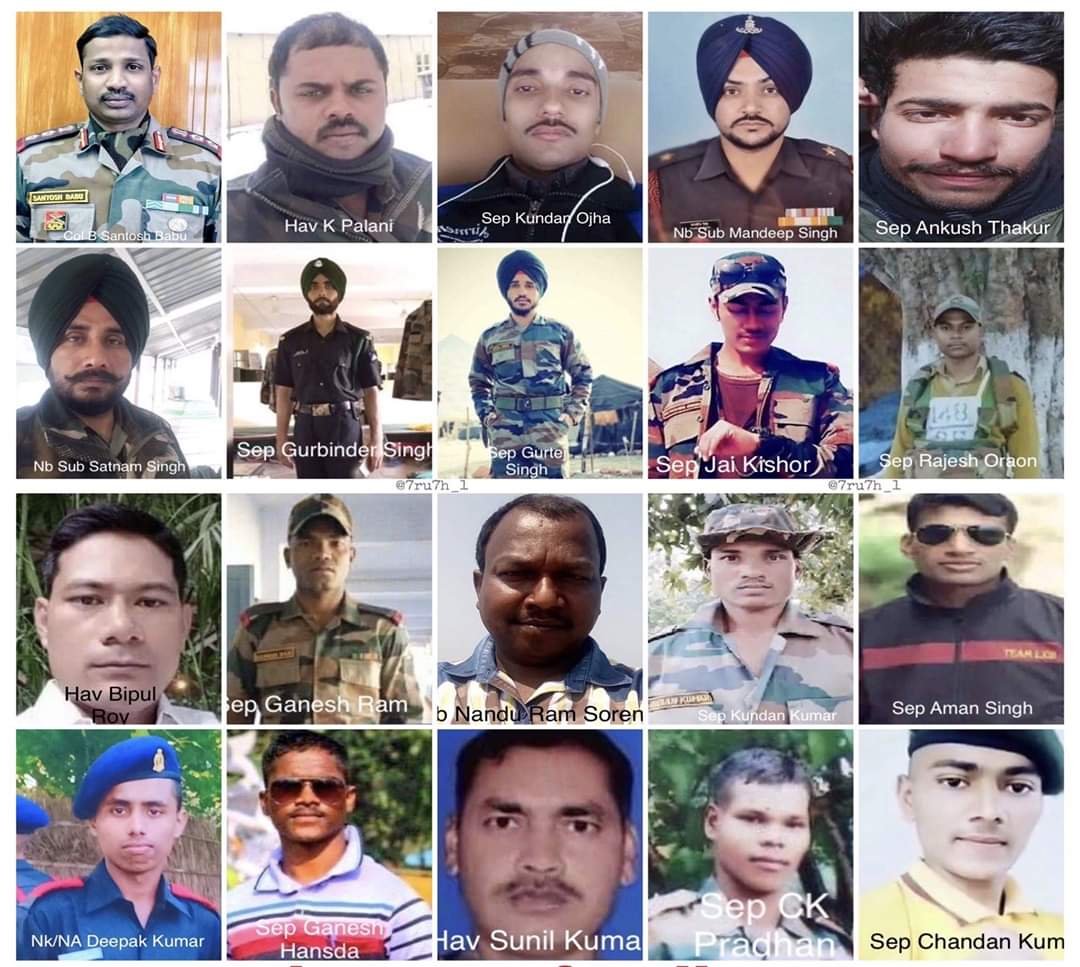
Soldiers who attained Veergati during #galwanvalleyclash. Even includes a Nursing Assistant (bottom left) from Army Medical Corps. It is up to @narendramodi gov to ensure their sacrifice does not go in vain. Dragon needs to be punched in the face. Image
Names and native place of our fallen soldiers - they represent 11 of India's 28 states.
Details of our bravehearts from @rahulsinghx @htTweets
11 of them were under 30 with youngest one being only 21. One was to retire next year.
OM Shanti! Image
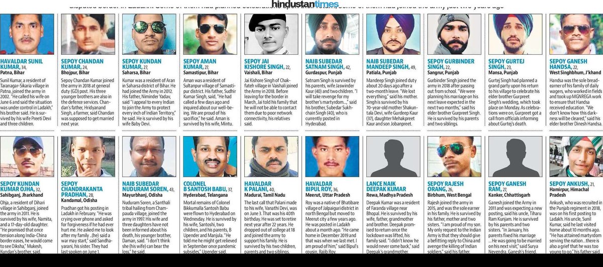
Koti Koti Pranaam...In life and in death, you served the motherland.
Well, no less a person than India's Foreign Minister is here to rebut false claims being spread by usual suspects.
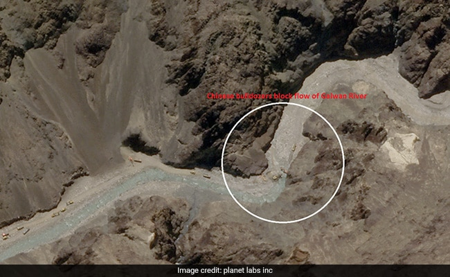
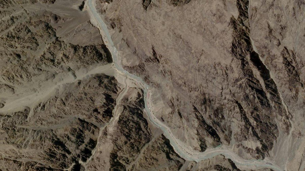
Earlier @Iyervval and now @VishnuNDTV have put forth an argument that the Chinese have stopped or disturbed the flow of Galwan River because water flow is not visible downstream from some point before LAC on Chinese side. There are some unanswered questions here -
(@ndtv image) Image
+
(1) Stopping water flow, w/o providing it with alternate channel, will mean that water will back-up along the channel. And create a small lake which will grown every minute.
(2) In the satellite image shared, there is no proof of this happening. Water flow is normal and +
+
+
there is no evidence of it backing-up and creating a lake. See image below from @ReutersIndia
(3) Further, comparison of historical and this satellite image shows that at multiple places, Chinese have expanded the river bank through land-fill.
+ Image
+
(4) This they needed to do to park their troops, tents and vehicles in the river valley.
(5) These would've been inundated had water flow been substantially restricted or stopped all-together. Again, this has not happened.
(6) So, what is the possible explanation?
+
(7) Chinese are expanding the river bank and channeling the water into a narrow channel.
(8) Chinese earth moving equipment is visible at the last point from where water is supposed to have vanished.
(9) My assertion is that all this activity is muddying the water and changing +
+
its color, which matches closely with the color of sand bank.
(10) I've used images from @Iyervval to explain these. All images belong to him.
(11) Image 1 - download & zoom this image. You can make out the earth moving eqp and muddy river water flowing in the marked channel
+ Image
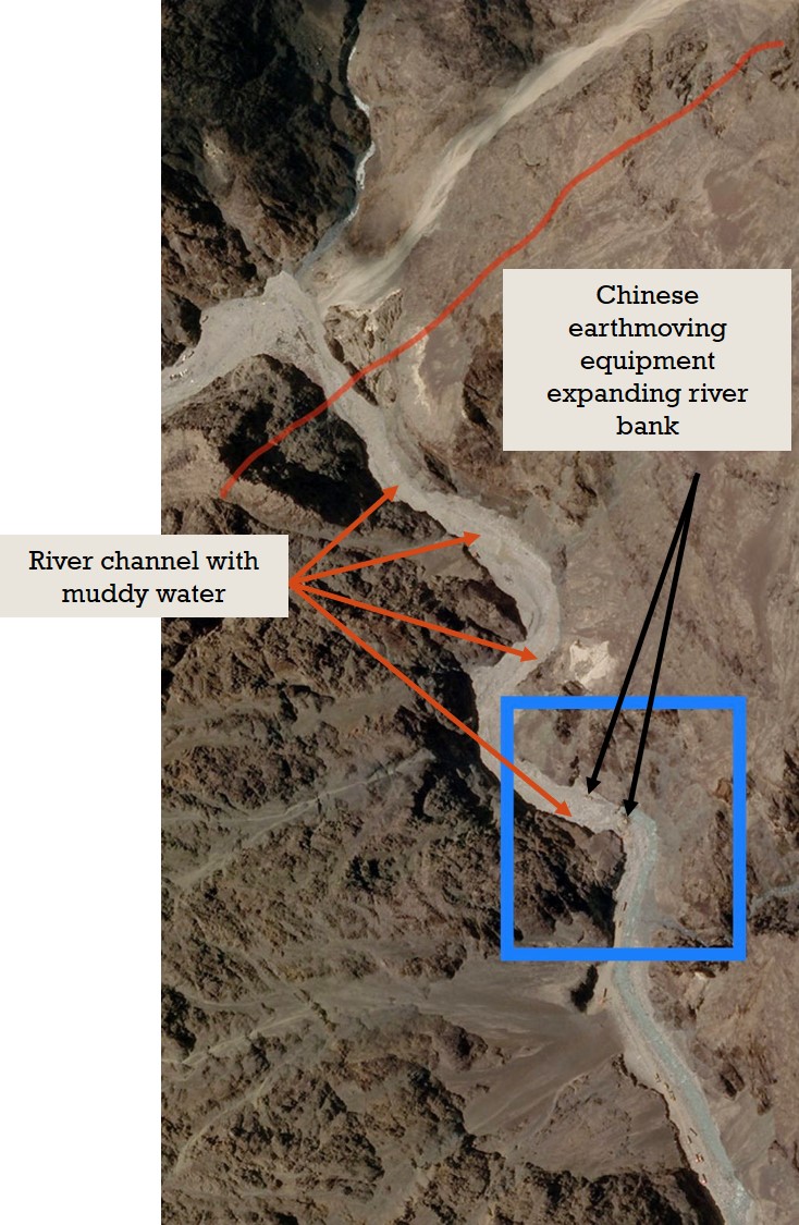
+
(12) Image 2 -
- Disregard the three arrows.
- Again, download and zoom the image.
- You'll see muddy water flowing along the marked channel (brown color).
- Indian bridges are also visible.
(13) Muddied water in my opinion is the explanation here.
--FINISH-- Image
Detailed analysis by @IISS_org with high-grade satellite images (some shared in the article, some not), to tell you about overall troop deployment by the Chinese. And whether they've crossed LAC in sectors other than Fingers. (courtesy @Cold_Peace_ ).
iiss.org/blogs/analysis…
Some more details of what transpired in the evening of June 15.
hindustantimes.com/india-news/pla…
Reading various news reports and individual accounts, one this which is sure is that men from 16 Bihar fought valiantly, and that too against great odds. They gave back much more than they got. The clash wasn't one sided affair, even if the Chinese had planned it in advance.
+
+
But if you read accounts by some journalists, you'll get a picture as if Indians got slaughtered. As if only we were at the mercy of the Chinese. They make Chinese look at 9 feet supermen. And frankly, the language used in these articles is quite cheap. It is one thing to +
+
objective and factual and quite another to sensationalize an event and that too, with some really gutter level language.
- Army has moved two additional divisions into Ladakh; it already has one division.
- It is likely that three sub-sectors - (1) DBO/SSN (2) Chang-Chenmo/Chushul (3) Demchok are now responsibility of a division each for both defensive and offensive tasks.
tribuneindia.com/news/nation/su…
- Clarification issued by (PMO) on his statement.
- Now, each and every person, who called him a sell-out, including many veterans (one Lt Gen even wanted to impeach him!), will you please stand-up and apologize for your absolutely pathetic comments?
#GalwanValleyFaceOff Image
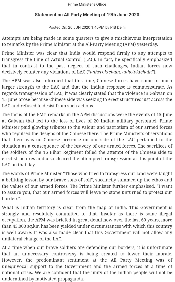
Reading comments of many a veterans yesterday, who were quick to jump to conclusion and cry sell-out and what not, I finally came to understand this adage -

'War is too important to be left to the generals'
Some excellent set of satellite images showing substantial Indian build-up in the Galwan river valley on our side of LAC from @detresfa_
Overall a balanced assessment by Lt General Panag @rwac48. He's one of the best when he restricts himself to military and strategic matter. BTW, I can see that he's no longer pushing the 'Chinese control heights around Galwan river' theory.
theprint.in/opinion/china-…
What do we have here?
(All) Images from @Nrg8000 show that the Indian Army may have actually occupied the heights/ridge-line on one side of Galwan river flash-point. Read article linked in previous tweet to understand its military significance. ImageImageImageImage
And funny thing is, some would have us believe that the Chinese have occupied heights on the Indian side with one or two battalions worth of troops!
Takeaway - Don't take everything at face value. Use the basic smell test. If doesn't make sense, it might well be BS.
I had by mistake putout tweets in other thread. Putting them here for record and continuity of the thread.
+
When analyzing reports about the Chinese having intruded 'X' km inside Indian territory, we ideally need these data-points:
1) Indian territory from which point?
2) Indian claim line?
3) What is the difference in km between the Indian and the Chinese claim line?
+

For example, in Pangong Tso, it is 8 km between F4 and F8.
3) How much of this claim does still hold? As in, how much west have the Chinese already come between 2000-2014?
4) How much of are on our side of LAC do they occupy and in how much do they patrol?
+
- For example in Pangong Tso, Chinese built road in 1999 but have occupied the area now.
- In DBO sector, news reports talk about two things -
(a) area on our side of LAC under physical Chinese control + roads built further west.
(b) Roads built into our side LAC.
Well, well, well.....@elmihiro @Firezstarter1 Image
Former Army Chief, under whom India led a successful Kargil campaign, on some aspects of speech by Sonia Gandhi -
Interview of the Indian Ambassador to China where he lays down the rules for engagement with China and need for it to honor the border agreeements:
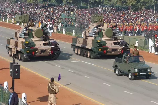
As India fortifies eastern Ladakh with defensive and offensive formations, one thing it misses is a medium range SAM system in 90-100 km range, though 100-150 km would be ideal. Couple of MR-SAM regiments would've provided over-lapping AD umbrella for own troops.
From low-to-high, we would've by now deployed Shoulder Launched SAM, self-propelled gun+missile AD system like
ZSU-23-4 'Shikla' (upgraded) and/or Tungushka, SPYDER (from IAF) and Akash (Army and IAF). Rest, first point of AD will remain fighter a/c of IAF. ImageImageImageImage
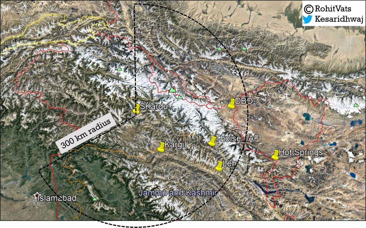
[Pakistan Air Force - Qadri Air Base, Skardu ]
- Reports say China has placed 40 J-10 fighters at Skardu.
- However, Skardu doesn't have space to host so many fighters.
- Nevertheless, 300 km radius from Skardu puts most of Ladakh under the range of fighters based there.
+ ImageImage
+
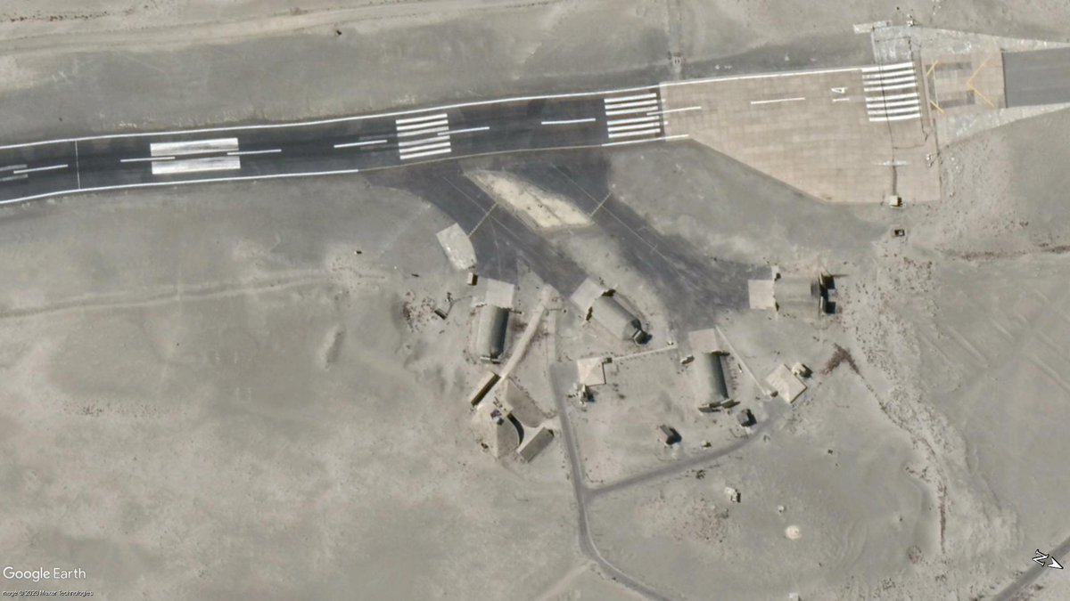
- Skardu has 2 runways; one 3.64 km/11,000+ feet long and other is 2.66km/8,700+ feet long.
- It has 8 Hardened Aircraft Shelters (HAS) in two cluster of 4 each on either end of main runway.
- 2nd parallel runway of same length as main runway is seen under-construction. Image
+
- Given location of HAS, they also act as ORP (Operational Readiness Platform)
- Since HAS is next to runway, planes can take-off quickly
- Fighters on ORP are fueled+armed & expected to be in-air within 2-min of alert; pilots are sitting ready in a bunker nearby.
+ ImageImage
+
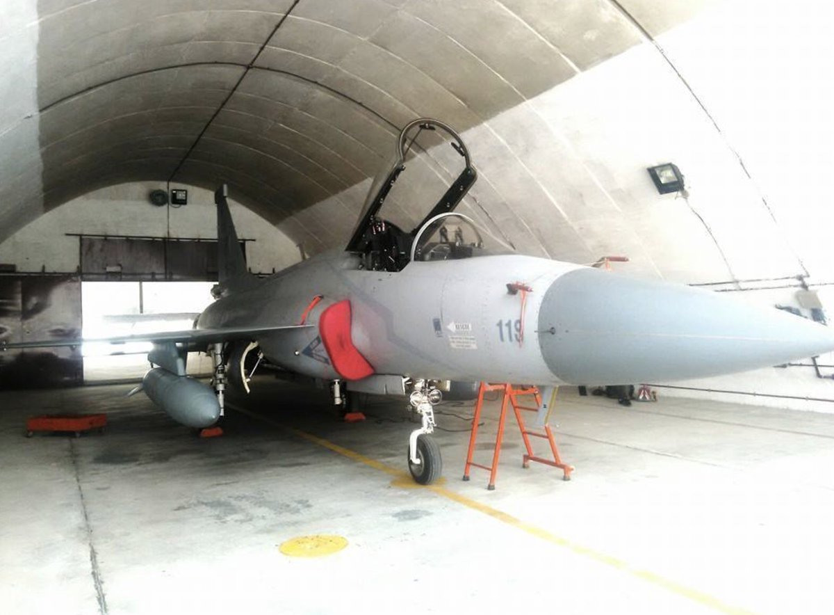
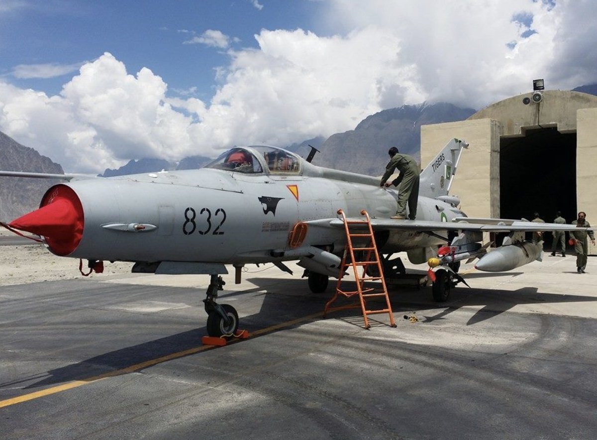
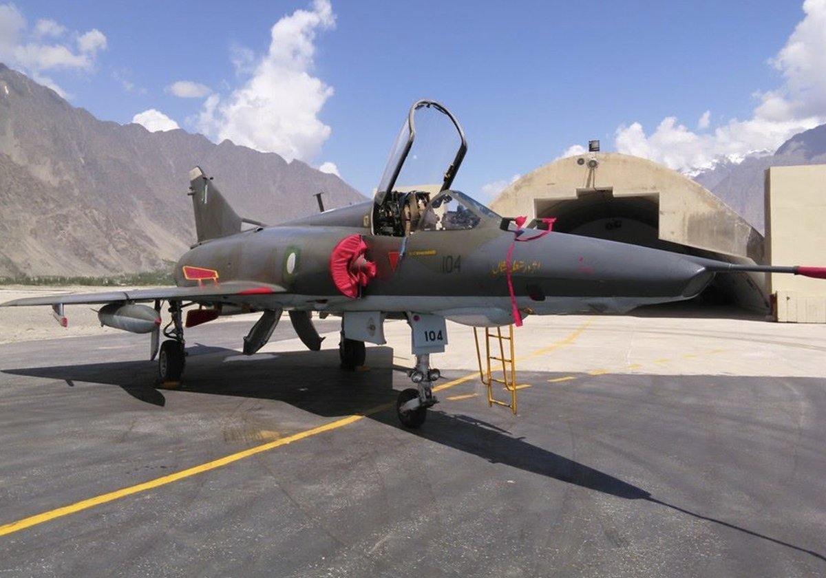
- Images below (source: defense.pk) of PAF fighters in Skardu (dates unknown):
1&2) JF-17 (No 16 'Black Panther Squadron)
3) Mirage-5 ROSE III (No 27 'Zarrar' Squadron) ??
4) F-7PG (No 17 'Tiger' Squadron) ImageImageImageImage
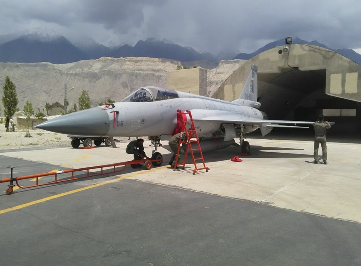
Finally, a short video of JF-17 taking-off from PAF Base Qadri, Skardu. The fighter has to go to one end of the runway and required almost the entire 3.6 km length of the runway to take-off. This is how high altitude impacts aircraft performance.
--END---
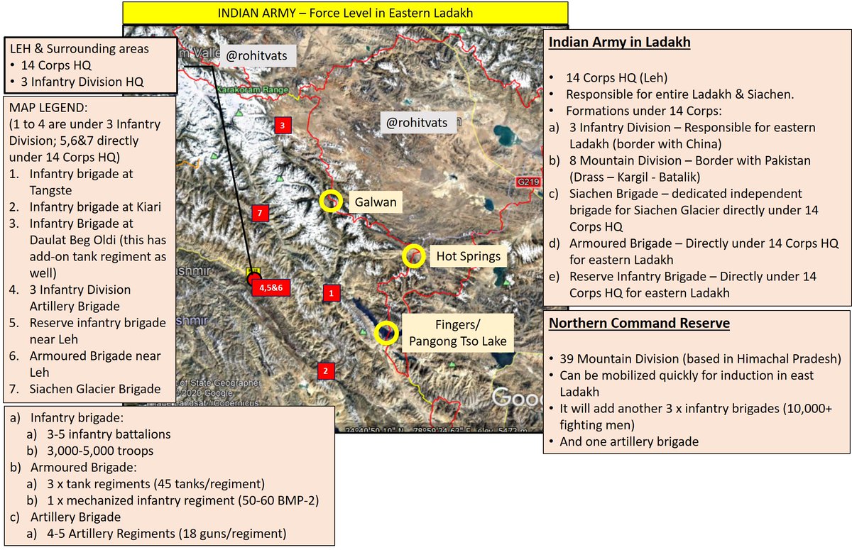
[Indian Army - Force Levels in Eastern Ladakh]
- News reports speak about India having three divisions facing the Chinese.
- A division each based in HP & Western UP have been moved to Ladakh
- In a month, we've gone from Map 1 to most likely Map 2 (deployment is my assumption) ImageImage
+
- I've assumed that a division each for DBO Sector, Central Sector (Hot Springs, Pangong Tso, Chushul, Spanggur Gap) and Southern Sector (Demchok funnel and Chumur).
- Ideally, two divisions would be upfront while one division is held as overall sector reserve +
+
- but given the geographical and infrastructure constraints, I don't think we can rush troops to reinforce sectors quickly.
- Plus, it is quite possible that roads/passes would've been blocked due to enemy activity (missile or strike)
- Also, lateral/sideways movement of own+
+
troops is not possible/difficult due to unique geography of the area.
- So, I've assumed that divisions would be deployed upfront; they'll further commit their brigade(s) as per requirement and keep balance in reserve.
----END---
+
As usual, forgot something 😋
- From a one infantry division+ other elements for eastern Ladakh to 3 x infantry divisions.
- From 1 x armored brigade, I won't be surprised if we now have 2 or even 3 armored brigades
- Not to mention attack helicopters and air defense assets.
A detailed article from @pranabsamanta on historical aspects of Galwan Valley.
Monsoon is NOT a good period for Indo-Pak war. Rivers and nullahs are full, ground is sloshed and muddy. Not good for Armor and general movement. Not that Pakistan can't create trouble on western front but options become restricted.
#ChinaIndiaFaceoff
A look at possible military objectives of PLA in Eastern Ladakh by Lt General Panag @rwac48
theprint.in/opinion/indias…
Looking up the Tibetan side from Ladakh, one realizes that in case of a major break-out by Indian forces, Chinese won't have anything in depth to stop them. Its just vast open land. Which brings me to another point - Chinese must attack to ensure we don't go on offensive.
Welcome to new ground realities. But I hope we don't use Tibetan card as a binary [0-1] thing.
Add to above the Chief Minister of Arunachal Pradesh. Someone tell the Chinese, you asked for it.
I've started getting this feeling that people managing Global Times are secret R&AW agents. And they deliberately put out such idiotic content to get trolled, ridiculed, made-fun-of and basically make China/Chinese appear as idiots.
"We're not going to allow for any misadventure from across the Line of Control as well as within the valley" - Imp interview with Srinagar based 15 Corps Commander by @VishnuNDTV
ndtv.com/india-news/no-…
Army digs in for a long winter in Ladakh. Indian Army has unparalleled exp in managing large body of troops in high altitude area. Need to expand the scale further. And while the Chinese have better road, their lines of communication are also very long.
indiatoday.in/india-today-in…
Chinese agreeing to a 2-km withdrawal can very well be because of rising water-level in the Galwan river, making their forward deployments problematic. Their actions need to be verified with quick response from our side in case of hanky-panky.
thehindu.com/news/national/…
Hello @MumbaiMirror @ians_india - 14 Corps, Leh, was NOT raised in 1962 after Indo-China war. I know you've copied this data from Wikipedia but the geniuses there have confused raising year of 8 Mountain Division (1963) with 14 Corps (1999).
mumbaimirror.indiatimes.com/news/india/300…
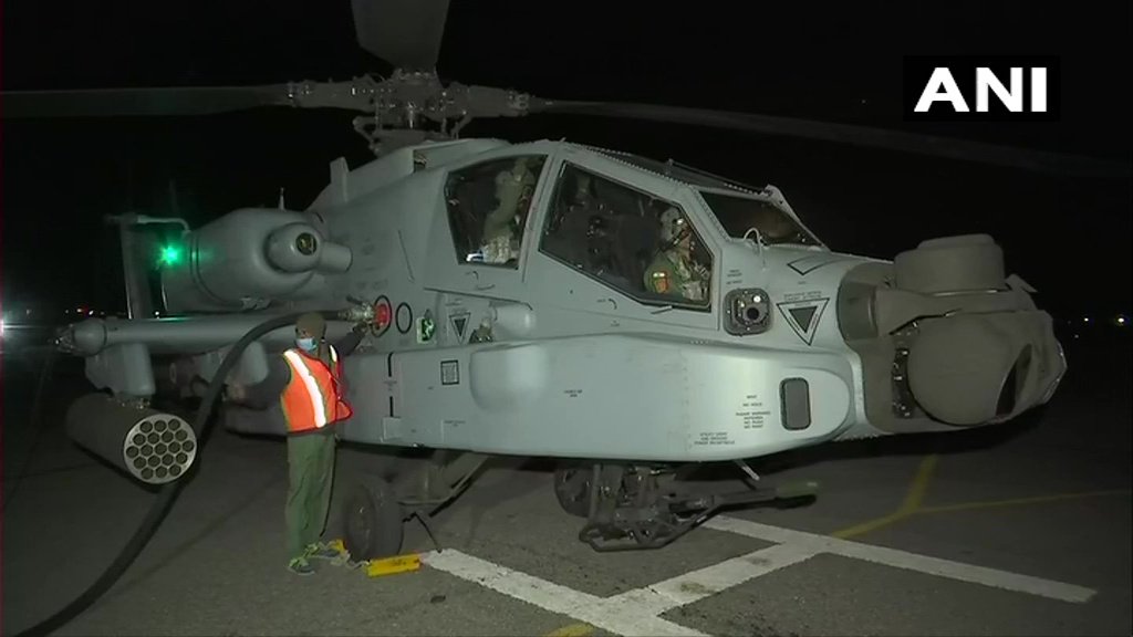
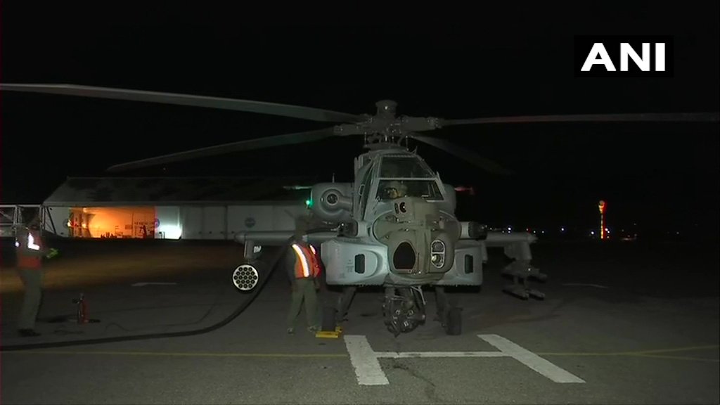
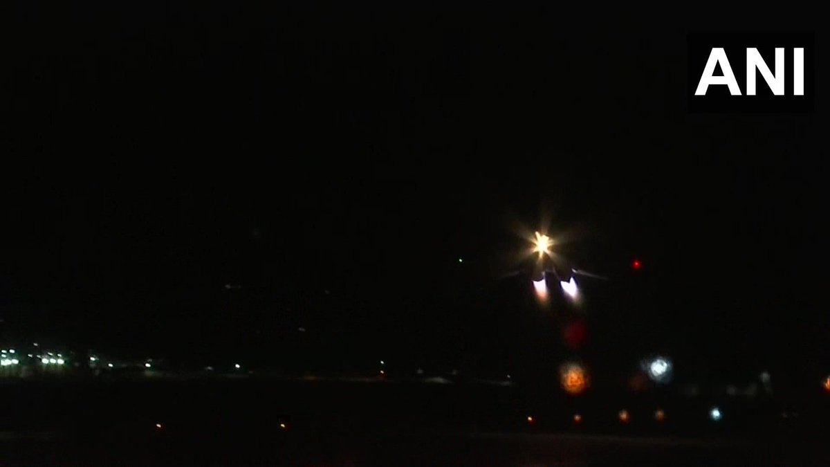
.@ANI with fantastic pictures and videos of IAF conducting night-ops in Ladakh theater. Kudos to excellent skills of IAF pilots, especially those flying Chinook and Apaches in the mountainous terrain at night. ImageImageImage
Link to videos -
Chinook ready for a sorties:
AH-64 Apache about to start night flying:
And while we're at it, IAF has also done test flights with helicopter and AN-32 aircraft at Chinyalisaur airport in central Uttarakhand region. This civilian airstrip will serve as Advanced Landing Ground (AGL) for the IAF and allow induction of men and material. Image
Video from @ANI showing AN-32 landing at the this airport -
Another video showing Mi-17 taking off -
This excellent video from WildFilmsIndia gives a great view of the Chinyalisaur Airport in Uttarkashi -
I had missed this one.
Need to find out which part of Sun Tzu philosophy on strategy talks about making enemies out of everyone around you at one go. Especially when you can't deal with even one of them decisively.
Excellent!
Since Chinese seem to be adept at tearing apart settled issues, well, two can tango!
A primer on Patrol Points along the LAC in Eastern Ladakh -
A technical point-of-view on pink tents in Galwan river valley:
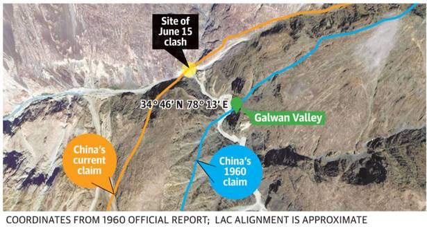
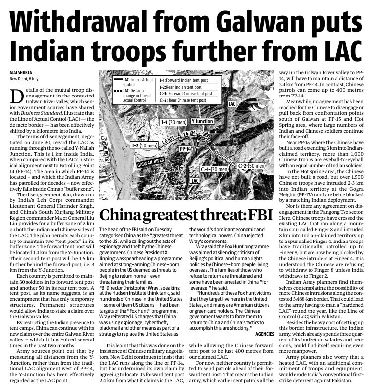
- In 1960, Chinese gave Lat-Long of their claim in Galwan River
- Info is discussed some days back (including by me)
- And when all his conspiracy theories are busted, Shukla ji shifts LAC/PP14 by ~500 meter to 1960 point
- Hence proved, India is losing land
- Mudi must rejine! ImageImage
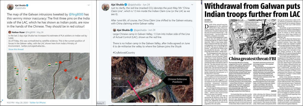
Chronology:
1. May 24: Shukla ji has no issue with location of LAC, only tents [1st image]
2. June 24: Y-Nullah junction is 1.5km inside Indian claimed line [2nd image]
3. July 8: It is 1 km inside Indian claim line.
- BTW, 2nd & 3rd puts LAC to east of Chinese 1960 claim line! Image
[PLA Ground Forces - Preliminary Assessment]
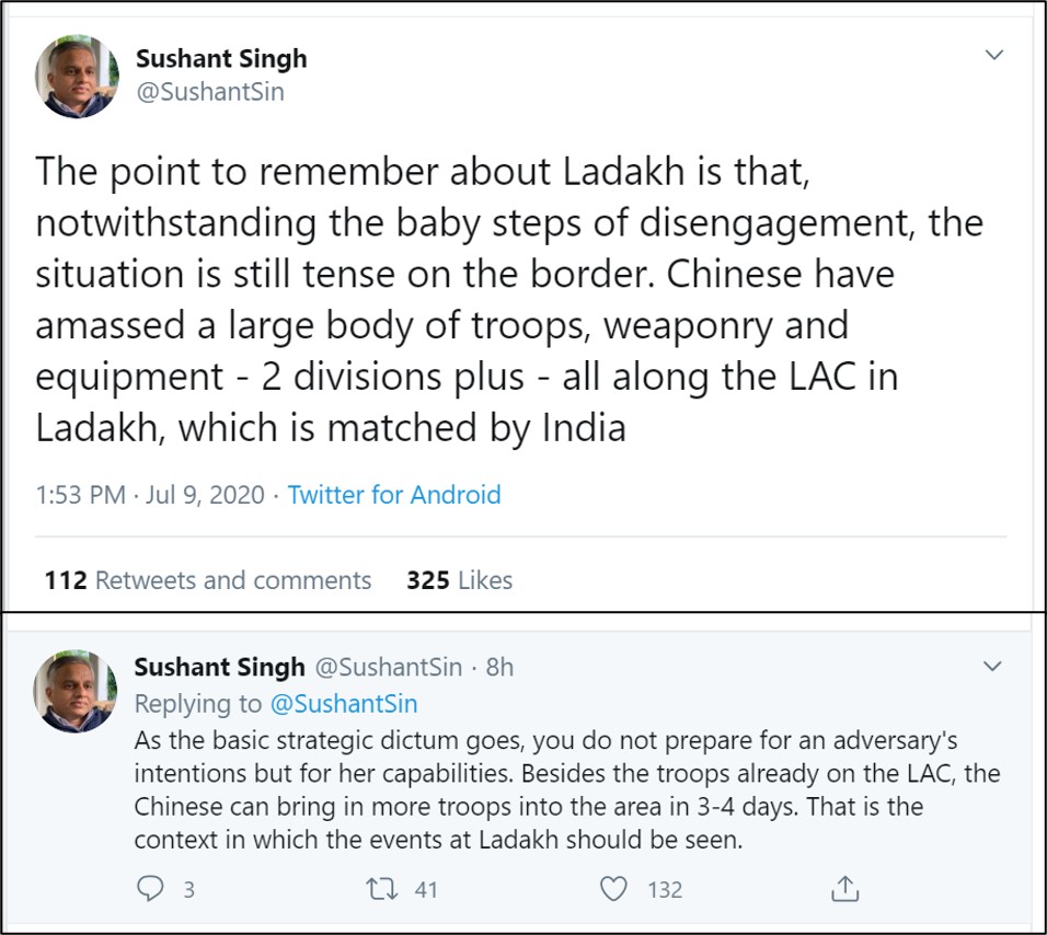
- While observation by @SushantSin is correct, I never find anyone do realistic analysis of where these Chinese troops are going to come from? And how long will it actually take them?
- We just assume Chinese will make things happen.
+ Image
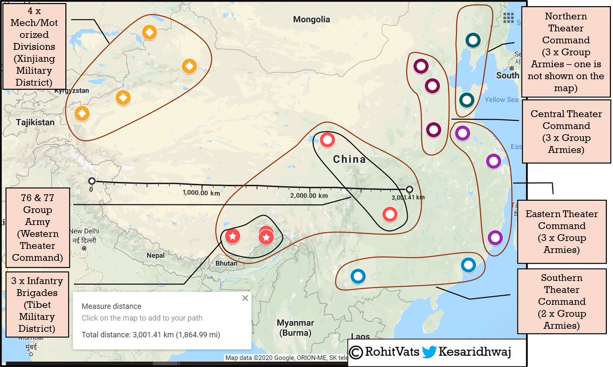
- Map: Divisions, Brigades & Group Armies (GA) under Western Theater Command and GA of other Theater Commands.
- 2 x Divisions from Xinjiang Military District are positioned against India in Ladakh.
- We've 3 or 4 Divisions against them (not shown on map)
+ Image
+
- If PLA has to move more troops against Ladakh, it will need to pull all divisions from Xinjiang Military District (XMD).
- Still, it will lack 3:1 ratio required for attack!
- Can China send more troops from Tibet Military District (TMD) or 76 & 77 Group Armies?
+
- If it does, then it will be left with very less troops opposite Arunachal Pradesh (AP).
- From Sikkim to eastern most AP, Indian Army has 3 x Corps who between them have 9 x Mountain Divisions.
- Chinese GA is broadly equivalent to an Indian Army Corps.
+ Image
- To ensure superior ratios and not disbalance eastern sector (where it as it is has inadequate strength), it will have to pull troops from other Theater Commands.
- From 11 Group Armies under other Theater Commands, China will need to commit 5-6 more Group Armies against India + Image
+ from Eastern Ladakh to Arunachal Pradesh.
- Basically, China will have to commit at least 65%-70% of their complete army against India to build favorable ratio and have any chance of success.
- But can it do this in 3-4 days?
- Look at the diance from Eastern Ladakh
+ Image
- Troops against Eastern Ladakh, Himachal-Tiber and Uttarakhand-Tibet border have to come from 3,000+ km away.
- And moving such a large body of troops in lakhs, has its own challenges.
- Even using a combination of rail (till Lhasa) and then road (Lhasa-Eastern Ladakh) will + Image
+ a week's time.
- Chinese will have to build provisions (fuel, food, medical aid, ammunition) for so many troops.
- Just for reference, a German Infantry Division in WW2 required 1,100 tons of supplies (ammo, fuel, ration etc) for one day of fighting in eastern front. Image
- And when the Chinese are moving these troops in very long columns across the barren plains of Tibet, they're susceptible to interdiction.
- Basically, China will have to mobilize at national level and spend considerable amount of energy if it wants to fight an all out war +
+ against India.
- And it does not have it easy.
- They might have excellent infra but they also need to move a very large body of troops, their equipment and all support paraphernalia from a long distance away.
- Their best bet is a short-sharp skirmish were they can create +
+ both surprise and favorable attacker-to-defender ratio.
- This way, they can claim victory and prove their point that they are the dominant power in Asia.
- Otherwise, while our lines-of-communication might not be A-Grade, they're shorter.
- And most of our troops are 24x7 +
+ committed to the Tibetan border from Eastern Ladakh to Arunachal Pradesh. They don't have to come from outside.
- And wherever required, like his present case, we've enough troops to further reinforce these sectors.
- As the infra improves, our ability to move reinforcements +
+ more rapidly, will also increase greatly.
- It is my considered opinion, that the Chinese Army is yet not ready, and in shape, to take on India in a full showdown.
- We're still 7-8 years away from that point.
---[END: PLA Ground Forces - Preliminary Assessment]---
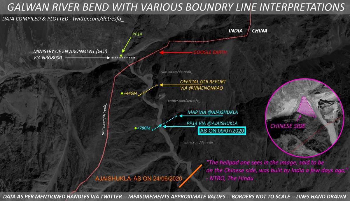
- In this map from @detresfa_ 'Official GOI Report' refers to discussions in 1960 between India & China on alignment of claim lines.
- On our inquiry, Chinese gave coordinates of where their claim line passed through in this area. This is the point it passes through. Image
A very hard-hitting interview of @Gen_VKSingh by @shivkunalverma where the former COAS calls out the propaganda peddled by Ajai Shukla and Field Marshal Eric Von Shawnstien.
[ Indian decision makers & 9 feet China-man Syndrome]
- There's a thin line in being a realist & being a defeatist.
- Former Indian FS, Shyam Saran, makes an ample display of latter sentiment here.
theprint.in/opinion/indias…
- Has such a mindset, based on some seriously faulty reasoning, been the driving force behind our FP earlier?
And worryingly, Shyam Saran is not the first one to display such a thought process.
- We recently saw similar sentiments being shared by another ex-FS, Nirupama Menon +
- People who've believed in, and internalized, such thoughts, will naturally oppose any aggressive stance by current government; for them it is quite a shock.
- Ergo, we're being bombarded with these sermons to be pragmatic.
- While the Chinese capabilities are raised to
+
+
mythical levels, doubt is raised over Indian capabilities.
- Chinese are made to look these 9-Feet tall supermen, who will win simply by showing-up.
- At start of this standoff in May, I'd made this prediction:
- But I never knew ex-FS's to be part of problem.
- I did two analyses earlier questioning this narrative of the Chinese ability to quickly move troops against India.
(1) Can China move its Paratroopers in a matter of hours against India in eastern Ladakh?
+
(2) Can China actually move troops against India in 3-4 days? I analysed geographical spread of the Chinese troops, distance from Ladakh, and possible time required to move them against India.
- While we need to ensure that we don't lose sight of the ground realities and are pragmatic in our approach and dealing with the Chinese, at the same time, let's not swing to the opposite end of the spectrum and be in awe of them.
BTW, have people noticed that suddenly both Shyam Saran, and Shivshankar Menon, have suddenly become active? And offering almost the same advice?
Recent article by which explores the potential Chinese deployment against Eastern Ladakh.
indianexpress.com/article/india/…
An interesting and detailed analysis on the kind of force level required by India in Eastern Ladakh to ensure we deter the Chinese while maintaining offensive capability on western front as well:
The current reinforcement levels which we've pushed into Eastern Ladakh actually end-up justifying the analysis done by Ravi Rikhye - @Editor_Orbat
While I agree with @Editor_Orbat on many points raised by him, we cannot raise two armies - one dedicated solely for China and other for Pakistan.
- We need a strategy of holding off one, while taking on the other.
-Create swing troops which can be shifted from one theater +
+ to other depending on the crisis.
- For that, we need very good infrastructure (road+rails), and investment in airlift capability.
- Also, need higher mechanization in plains, with more firepower to punish Pakistan if it tries to intervene in Northern Areas when India and +
+ China might be engaged in a stand-off and conflict.
- And most important aspect in my opinion is to have a large and very robust IAF.
- That's a true swing capability.
- Best way to deter or punish Pakistan is our ability to overwhelm their air force, even in case of two +
+ front war in 48-72 hours.
- Pakistan cannot afford to continue any war if it loses 75-80 of its fighter a/c in 48 hours.
- And without air-cover, whole of Pakistan and army are sitting ducks.
- Finally, our political aim in case of Sino-India war should be absolutely clear.
While the Chinese in 1960 gave coordinates of a point at which their claim passed in Galwan Valley, it is incorrect to draw the blue colored line. This is misrepresenting the situation @ananthkrishnan - It means the whole LAC has shifted. A 400+ meter
+
thehindu.com/news/national/… Image
+
shift in the exact point in the valley suddenly becomes loss of multiple square kilometers of territory. Unlike Pangong Tso lake, where we know the difference in perception of LAC thanks to @sdinny14 @nitingokhale, no such two separate LAC lines exist here.
From our former Army Chief. A prescient take on Sino-Indian relationships in 2005 where he rightly calls out the future trajectory. Some of wrongs mentioned by him were corrected by current GOI. Need to do more.
Map of the road he's talking about. It passes through the Saser La pass (which is heavy snowbound in winters). It will give us alternate option if and when new DBO gets interdicted.
ImageImage
Who else but @MandeepBajwa brings you the details of the Chinese deployment against India in Eastern Ladakh. The Chinese formations he talks about, come from the Xinjiang Military District shown in top-left corner of the map below.
indianexpress.com/article/india/… Image
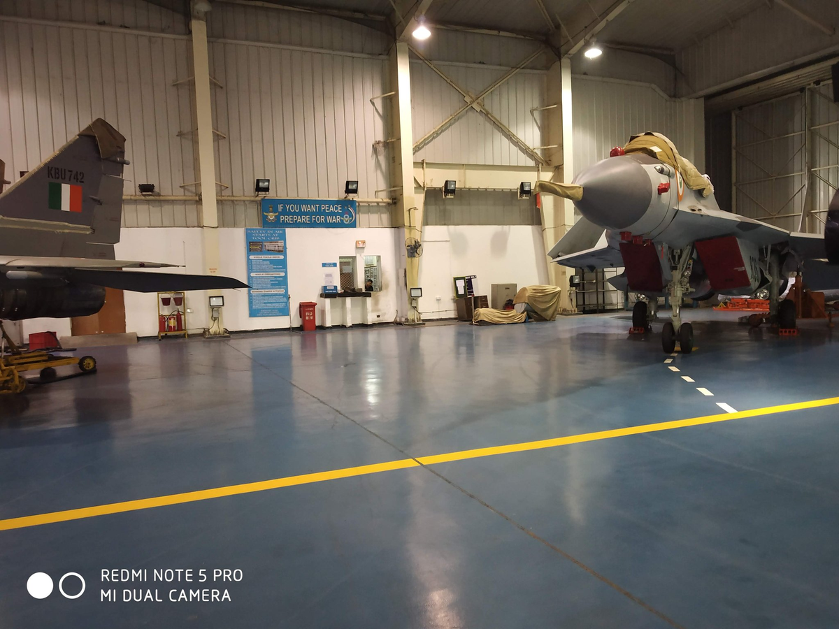
With Navy's Mig-29K headed for north India, these 2-year old pics of Mig-29K in Adampur, home to IAF's two Mig-29 squadrons, show that IAF & IN have trained & practised together. They would be familiar with each others SOPs and will be able to gel together.
pics: @neeraj_rajput ImageImage
Beautiful....how we missed the opportunity to induct at least 24 of these amazing machines. They've already paid for their cost many times over. Especially the induction of armor/tanks into Ladakh in a short time wouldn't have been possible.
A timely article on challenges faced in deploying and operating mechanized assets - tanks and infantry fighting vehicles - in the high altitude and icy cold eastern Ladakh theater.
SINCE WHEN WAS GALWAN CHINESE?
- From Claude Arpi, one of the foremost experts on Tibet, and Sino-Indian boundary issue.
- If you want to understand the nitty-gritties of McMahon Line, read this fabulous book by him:
usiofindia.org/publication/cs… Image
“General flying is not allowed and ground commanders have been asked to assess and constantly keep a vigil on the ground. The agreement allows use of UAVs but not in an indiscriminate manner"

-What is discriminate and indiscriminate manner in UAV usage?

thehindu.com/news/national/…
Lt Gen Katoch @KatochPrakash on urgent requirement for India to have a National Security Strategy and Strategic Defense Review (SDR) so that we can tailor our response and troops as per an overall objective.
PS: He mentions nuclear tipped Brahmos😲
news18.com/news/opinion/c…
Lt Gen Panag @RWAC opines that India may need to go on offensive to ensure return to status quo.
- He suggests a force level comprising of 3-4 divisions and 3-4 armored brigades for India to obtain its objectives.
@ramana_brf @Editor_Orbat

theprint.in/opinion/india-…
Read the above article with his @RWAC earlier article where he elaborates on possible Chinese aims in eastern Ladakh @Editor_Orbat
@rotormagic @ramana_brf ramana, we did wargame these very possibilities.
theprint.in/opinion/indias…
[China 'Surprise' on LAC]
- Multiple people have said we were surprised by the Chinese on LAC.
- I for one, don't buy this surprise theory.
- I've an alternate explanation - there (was) a delay in decision making as to how to react to the Chinese moves.
- Unlike Pakistan, where+
+ LOC is defined, nature of engagement is known, it is a 0-1/binary thing.
- You cross LOC OR threaten Indian troops/infra OR fire at us, we will shoot.
- Not in case of China and LAC.
- What does a local commander, say CO of an infantry battalion, do if Chinese come with +
+ tents and start pitching them on our side of LAC, right in front of his eyes?
- Does he fire at them? He can't. Best he can do is send a large body of troops and you'll see fisticuffs and a brawl.
- So, he sees the Chinese doing something out of ordinary, and he informs his +
+ higher ups.
- He takes precaution to ensure Chinese can't come across area in our control.
- But when it comes to Chinese actions in area between Indian and the Chinese LAC, orders come from very top.
- And by very top I mean the PMO and Foreign Ministry; MOD and Services will+
+ act on advice of PMO and Foreign Office and the China Study Group.
- In such instances, escalation is controlled from the top.
- Even in present stand-off, Chinese incursion has been Fingers Area of Pangong Tso lake where there is a difference in perception of LAC.
- But when +
+ it came to Galwan river, not only were the Chinese quickly confronted during their initial incursion but made to go back.
- The fight happened over Chinese presence a few hundred meters of our side.
- Chinese were expecting a similar ambiguity or delay in response in Galwan +
+ as in case of Pangong Tso or Depsang Plains.
- And when the violent counter-attack happened from our side, that's when they were stunned.
- But same thing did not happen in Pangong Tso or Depsang Plains.
- Because as I said, our mechanism to deal with the Chinese in this +
+ grey zone of 'differing LAC perception' gives them space to exploit our vulnerabilities.
- Same thing has happened this time as well.
- By not confronting the Chinese at the time of encroachment, due to laid out mechanism, we gave them space.
- And now, we've to retrieve the +
+ situation from this point onwards.
- Going ahead, it will be important to put down SOP in place to ensure that decision cycle when it comes to dealing with such encroachment(s), is not delayed.
- And that we do not lose the initiative.
Some counter-points with respect to hoopla being created around Indian need to now support a large body of troops in winters in Eastern Ladakh. And how the same doubts are never raised about China.
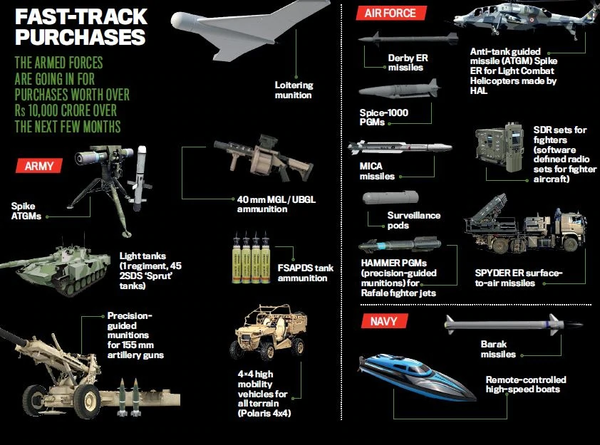
The boondoggle that is Indian defense procurement. Most of the outstanding ammo problem is because of gross inefficiency of Ordnance Factory Board (OFB). But I must say, I'm quite surprised with choice of 2S25-Sprut-SD as choice for Light Tank candidate.
indiatoday.in/magazine/speci…
All these requirements had been projected by respective Service for a long time. They're been processed now because enemy has literally lit a fire under our arse. The cynic in me wants such period wake-up calls because our politicians and babus move only in such a scenario Image
Let's look at the requirements:
(1) Army:
- Loitering ammo: No Domestic Alternate (NDA)
- Spike ATGM: This was bound to happen; import was shelved for domestic program but domestic product is still quite some time away.
- Graphic below also speaks of Spike-ER ATGM for LCH + Image
+
- again, this should've happened much earlier. Army has got almost its entire lot of 60 Rudra attack helicopters and LCH will enter into service soon.
- Both are w/o ATGM as HELINA/Dhruvastra is expected to take some time to reach maturity.
+ Image
- 4 x 4 High Mobility Vehicle: I'm sure some Indian company/Indian subsidiary can provide this solution.
- 40mm UBGL: Well, this is a shame because while OFB lists both UBGL and MGL, it does not show ammunition for either of it under its catalogue.
+
- Precision Guided 155mm shell: This would be US Excalibur. Again, NDA.
- FSAPDS Ammo: This import is only because of massive screw-up by OFB in producing this vital ammunition. I wrote a whole thread on it () Image
- Light Tank: For mother of God, why the Russian 2S25 Sprut-SD light tank? Even the Russians aren't buying them. Unless, the IA thinks both airdrop and amphibious capabilities are a must, for both, western and eastern theaters, it makes no sense. To me at least.
- Also, I hope + Image
+ we don't end-up with a situation where only 45 tanks come under emergency purchase and we then forget about it all-together. Till next bushfire!
- I would honestly expect the Army to work with DRDO on this and evolve a domestic platform.
+
+
(2) Indian Air Force:
- All standard purchases.
- Spike_ER has claimed range of 8km while ERII has 16km range with 2 way RF-Data Link (This means Dhruvastra is still some time away)
- Software Defined Radios (for entire fleet) - Projected requirement is almost a decade old + Image
(3) Navy:
- Again standard purchases.
Indian Army may move additional troops to LAC.
(Read the report - Indian journalists have the ability to present even the mundane in most negative sense. Heights!]
economictimes.indiatimes.com/news/defence/i…
Let general Panag @rwac48 on need to fortify certain sectors of eastern Ladakh to nullify the geographical disadvantages in these sectors.
theprint.in/opinion/if-ind…
Stand-by for some interesting analysis. Coming in next hour.
[Pangong-Tso/Fingers Area]
- Google Earth has updated satellite image of a narrow area around Finger 4-8 and Khurnak Fort
- Update is as of 15 June 2020
- Remember, this analysis is of situation as of 15 June, it's been 45 days since, and we don't know what is present situation
+
+
- Map1: Satellite image of area between BM-1 to BM-8 and black oblong shape has been updated.
- Map2: PLA positions visible in updated image. New posts along F4 ridgeline, new clusters, ammo storage, artillery site, tracks are visible. ImageImage
- Map3: PLA positions on F4 ridgeline and in the valley immediately to east of it.
- As I will show later, reason I believe the posts on ridgeline are Chinese is because of the way they are oriented.
- Here we can see major clusters in valley to support the troops on ridgeline + Image
+
- Track from the valley going up towards higher reaches (full extent not visible)
- Even PLA positions on ridge are visible only till a point; beyond that satellite image is not updated.
- Map4: View from F4 ridgeline; it dominates Indian positions to west.
+ Image
+ Map5 & Map6 - Close-up of 02 PLA posts on ridgeline which shows tents, inter-connecting tracks, tracks leading back-down into the valley, store/ammo dump & defensive walls.
- Again, it is orientation of posts which makes me believe these are Chinese (happy to be corrected)
+ ImageImage
+
- Map 7,8 & 9: Chinese clusters to immediate east of F4 ridgeline.
- The famous 'pink tests' are actually camouflage nets which appear pink to satellite image. These hide the underlying object.
- In these images, you can broadly make out what lies underneath.
+ ImageImageImage
+
- Map 10 & 11: Chinese cluster and prepared gun position in Sirijap area.
- Map 10 shows various vehicles below camouflage nets with earthwork around them
- Map 11 shows 14 prepared gun positions. ImageImage
+ Map 12,13,14 & 15: Clusters close to Khurnak Fort including a field hospital & one large 500 x 600 development which looks like ammunition dump.
- Map 14 shows extensive camouflage; not possible to make out underlying asset. This is much more elaborate than seen in other areas. ImageImageImageImage
No surprises here at all. Given the kind of infrastructure they've created here and manpower deployed, Chinese haven't come to go back. With every passing day, inevitable beckons.
indiatoday.in/india/story/ch…
Good article which gives a peep into the Chinese armed forces of People's Liberation Army. Do read.
m.hindustantimes.com/analysis/the-p…
Informative article. Indian Army has fortified the DBO Sector and Depsang Plains which fall under it. A quick analysis basis data in the report -
(1) Instead of a brigade earlier (~3,000+ troops), we now have a whole division responsible for this area
timesofindia.indiatimes.com/india/india-st…
(2) Tanks:
- Report says we'd earlier committed a whole Armored Brigade to this sector.
- Which is 3 x Tank Regiments.
- In my opinion, this was done with reinforcements brought from outside Ladakh.
- But it seems we've increased this further with additional +
+
tank regiments from rest of the country.
- If we go by the news report, it is likely that we're using reserves from one of the Strike Corps.
- A report by @MandeepBajwa had spoken about Chinese having moved a Mechanized Division opposite DBO Sector.
- With additional tank +
+ regiments, which I'm sure are backed-up with additional mechanized infantry regiments, we seemed to have gone toe-to-toe with the Chinese.
- Here, it is important to add that while Indian Army tank regiments has 45 tanks, Chinese tank regiment has 33 tanks.
+
+
- Just for reference, 6 Indian tank regiments (270 tanks) is equivalent to 8+ Chinese tank regiments.
- India seems to have created a strong reception party for the Chinese, should they decide to invite themselves into India held territory.
Opinion by Brig RJS Dhillon @ParaRjs on how to go about challenging the Chinese encroachment with eg of DBO sector. Brought to you by @Libertarian196 . Very good read. Though, in my opinion, this sector now has heavy tank presence from both sides.
indiasentinels.com/opinion/indias…
Indian and Chinese troops clash in southern bank of Pangong Tso lake.
pib.gov.in/PressReleasePa…
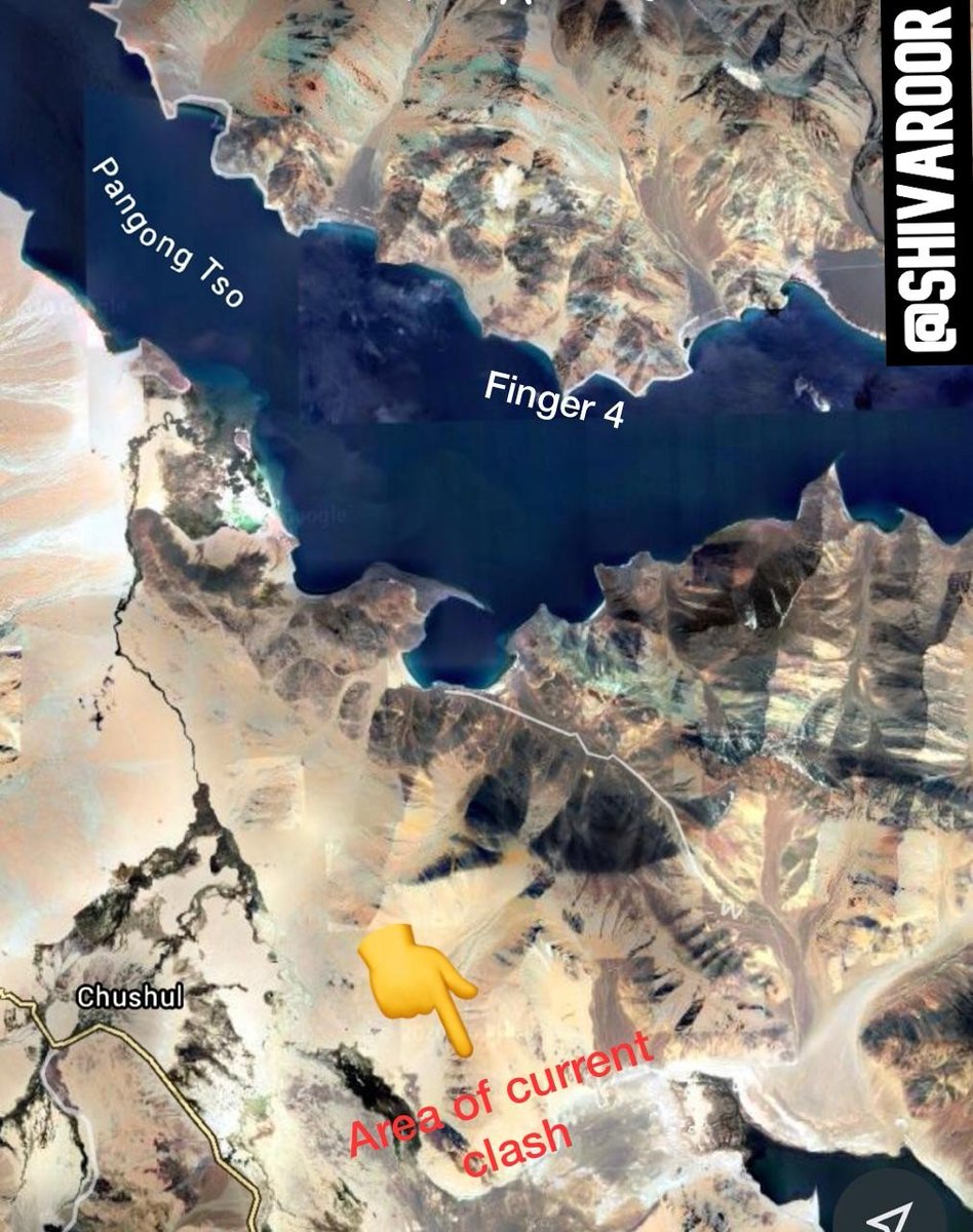
@ShivAroor says the hand-to-hand fighting took place near Chushul. This means the latest clash has happened in a completely different sector from previous flash-point. Awaiting more clarity.
A quick primer on the Chushul sector along with a bit of history. During the 1962 war, Chushul was the scene of a fierce encounter between IA and the Chinese and relative to other sectors, IA gave a much better account of itself. The epic Battle of Rezang La also happened here. ImageImage
Possible location of clash as per @ShivAroor Image
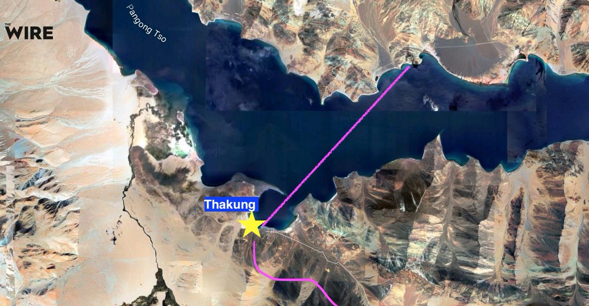
.@thewire_in gives a slightly different location of clash. This would be 6-7 km north-west. Image
So, as usual, Chinese were back to their sneaky tactics but this time, IA detected the movement, and thwarted their attempts. Clarity on the events from @nitingokhale.
Full statement of the Chinese Western Theater Command's spokesperson.
Seems PLA had their 'Vikas' moment yesterday! Image
😍😍😍
From Neeraj Priyadarshi @IndianExpress Image
- An update from @VishnuNDTV.
- In my opinion, now that the shoe is on the other foot, it will be interesting to see how China responds.
- Chance of a localized sharp-firefight are high at this stage.
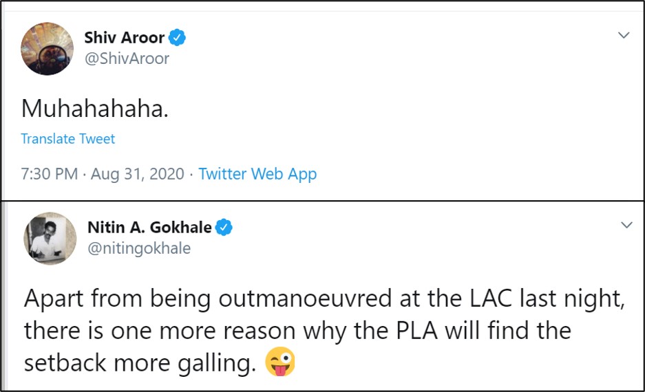
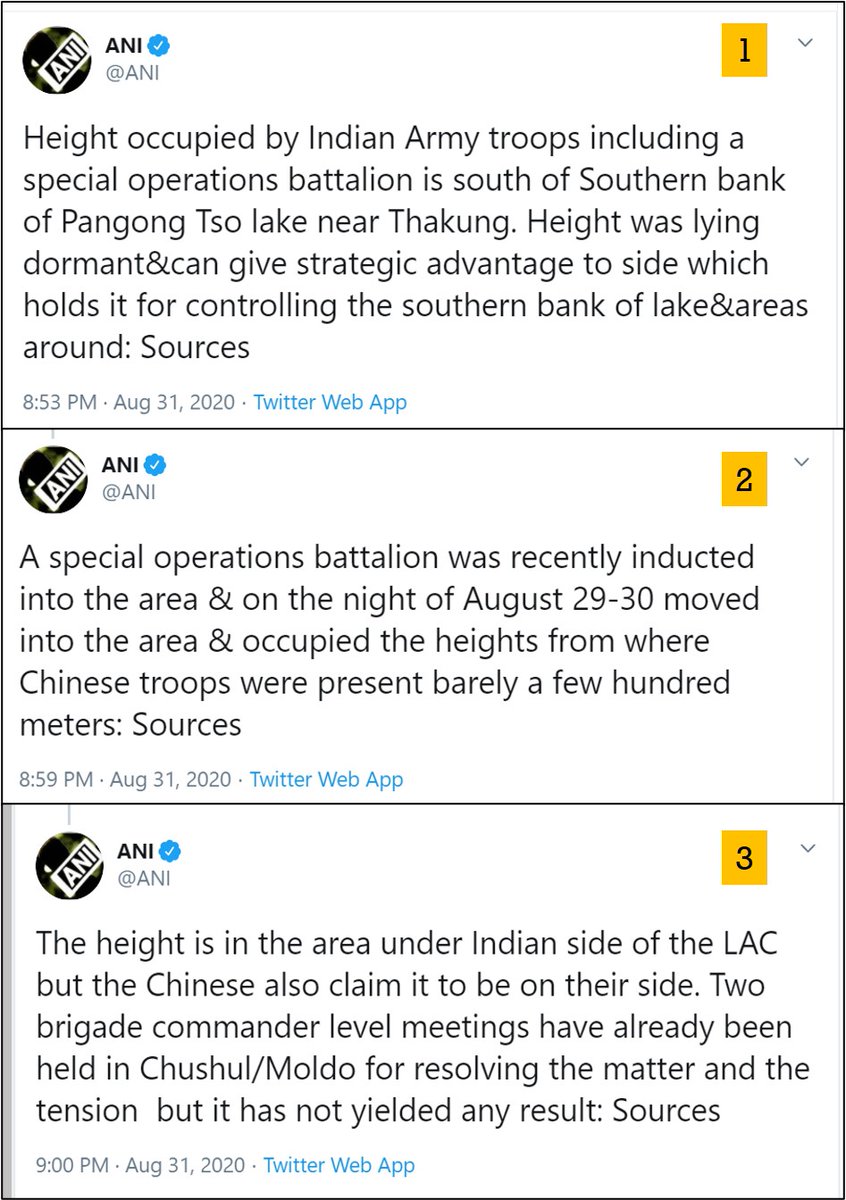
ANI updates. Takeaway -
1. Given Chinese action on southern banks of Pangong Tso, IA has taken control of some dominating heights in the area
2. And going by the grapevine, it seems we've used Tibetan staffed Special Frontier Force (SFF) troops
3. Chinese would be pissed no end! Image
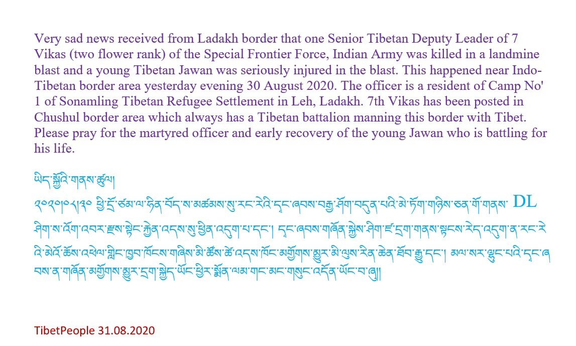
Well, it seems SFF (7 Vikas) suffered some casualties in the operation. Below details from @TibetPeople Image
A song written by a Tibetan soldier. And also sung by a Tibetan soldier (not the whole song and I don't know if song writer and singer are same):

Hum hai Vikasi, tibbat wasi
Desh ki shyan bharayenghye

Jab jab humki milega moka
Jaan pe khel dekhayenghye

Well, it seems India is dominating substantial area ACROSS the Chinese the LAC.
- All these years, Hans have been treating Tibetans harshly
- Now, imagine what would be going through the mind of Chinese soldiers in Chushul sector, who know that there are some heavily armed & very dangerous Tibetans looking for an opportunity to hunt them!
And important aspect of Foreign Policy highlighted by @elmihiro which we should exercise.
It seems there were two actions:
- August 29/30 : PLA tried to fortify some heights in southern Pangong Tso lake to which IA reacted.
- August 30/31: Counter-Indian action by SFF troops to occupy some critical heights in adjoining area causing serious casualties to the Chinese
Here is an article by Ajai Shukla where he says PLA has occupied two heights which were on Indian side. But the map which he's used itself shows them on other side of LAC on the ridge-line. So, what's the reality?
ajaishukla.blogspot.com/2020/08/pla-ag…
And here's a report by @sneheshphilip @AmritaNayak3 which claims no Indian heights have been lost and on the contrary, Indian Army is dominating 'four locations and certain passes including Rezang La'
theprint.in/defence/in-rac…
Missing some Tweet in this thread? You can try to force a refresh.

Keep Current with VatsRohit

Profile picture

Stay in touch and get notified when new unrolls are available from this author!

Read all threads

This Thread may be Removed Anytime!

Twitter may remove this content at anytime, convert it as a PDF, save and print for later use!

Try unrolling a thread yourself!

how to unroll video

1) Follow Thread Reader App on Twitter so you can easily mention us!

2) Go to a Twitter thread (series of Tweets by the same owner) and mention us with a keyword "unroll" @threadreaderapp unroll

You can practice here first or read more on our help page!

Follow Us on Twitter!

Did Thread Reader help you today?

Support us! We are indie developers!


This site is made by just two indie developers on a laptop doing marketing, support and development! Read more about the story.

Become a Premium Member ($3.00/month or $30.00/year) and get exclusive features!

Become Premium

Too expensive? Make a small donation by buying us coffee ($5) or help with server cost ($10)

Donate via Paypal Become our Patreon

Thank you for your support!