New research led by @ggpersad & featuring @PabloWater. Using downscaled climate model simulations, we show that there is unexpectedly high inter-model agreement re: increasing extremity of California hydroclimate due to #ClimateChange. (1/n) link.springer.com/article/10.100… #CAwater
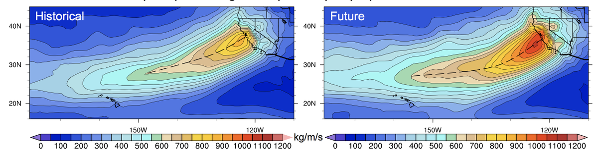
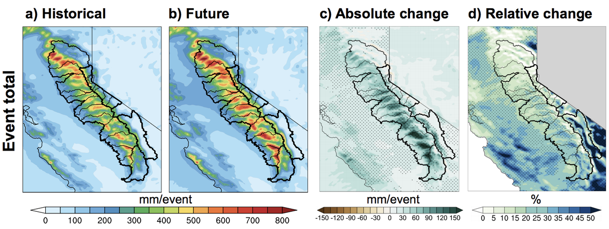
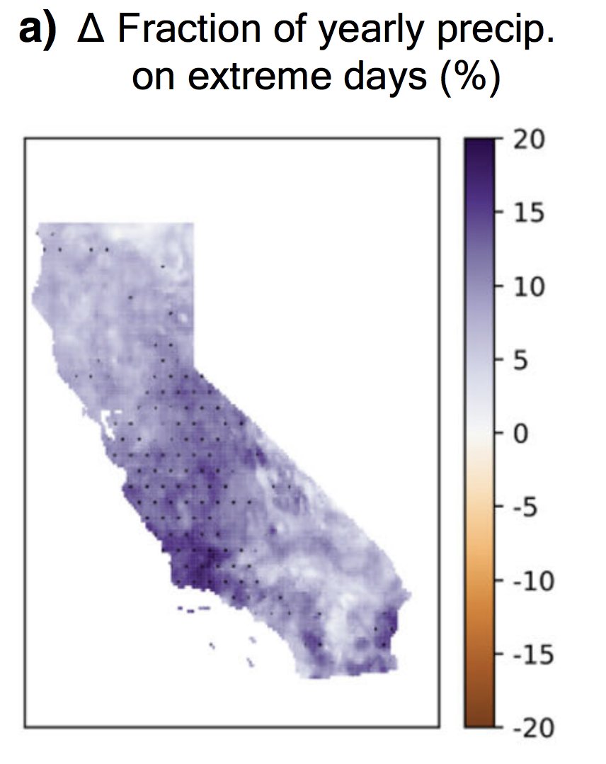
In general, climate models agree than an increasing fraction of California's overall precipitation will become concentrated into the most intense events--and that the most extreme precip events will themselves be substantially more intense. (2/n) link.springer.com/article/10.100… #CAwater
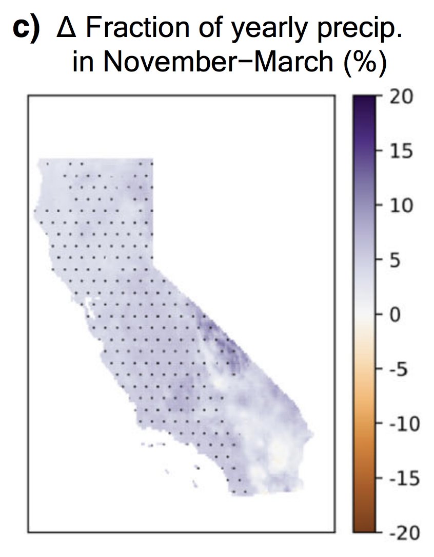
There is also agreement that CA's already pronounced precipitation seasonality will become even sharper--with more rain concentrated into winter months at expense of the autumn & spring. Consider the wildfire season implications... (3/n) link.springer.com/article/10.100… #CAwater #CAfire
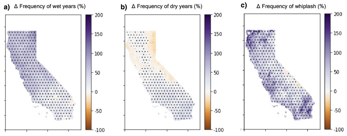
We also sought to replicate findings from our "increasing precip whiplash" work in 2018 (nature.com/articles/s4155…). We find a strikingly similar projection of increasing precip whiplash--driven mainly by increasing wet years but also a smaller increase in dry years. (4/n) #CAwater
Perhaps unsurprisingly, but still importantly, we find very large decreases in California's snowpack. In high warming scenario, lower/mid elevation snow regions see near complete loss of snowpack during the last few decades of this century. (5/n) link.springer.com/article/10.100… #CAwater
We also explicitly consider implications for water resources. More intense & strongly seasonal precip, plus huge snowpack declines, yield increased winter outflow but large decreases in storage rest of year--precisely when we need it. (6/n) link.springer.com/article/10.100… #CAwater
To me, one of the most striking findings here is that different models exhibit relatively high agreement regarding projected changes in extremes & seasonality--even though they don't all agree on changes in overall mean precipitation!! (7/n) link.springer.com/article/10.100… #CAwater
Ultimately, all of this suggests that we can actually make higher confidence statements regarding California's hydroclimate future than has previously been assumed--& that these changes are going to seriously test our existing water systems. (8/8) link.springer.com/article/10.100… #CAwater

• • •

Missing some Tweet in this thread? You can try to force a refresh
 

Keep Current with Daniel Swain

Daniel Swain Profile picture

Stay in touch and get notified when new unrolls are available from this author!

Read all threads

This Thread may be Removed Anytime!

PDF

Twitter may remove this content at anytime! Save it as PDF for later use!

Try unrolling a thread yourself!

how to unroll video
  1. Follow @ThreadReaderApp to mention us!

  2. From a Twitter thread mention us with a keyword "unroll"
@threadreaderapp unroll

Practice here first or read more on our help page!

More from @Weather_West

21 Sep
Fire weather update: relatively mild (near avg) temps will continue for a few more days across California. Calmer winds will result in poor air quality, as visible this AM. A weak cold front with a few light North Coast showers possible mid-week. But then... #CAwx #CAfire (1/n)
There is unfortunately multi-model ensemble agreement that a very strong ridge will build near CA and the West Coast by end of Sept., bringing yet another major heatwave by early October to CA, OR, and adjacent states. #CAwx #ORwx #CAfire (2/n)
Early indications is that this early Oct event will have potential to bring record heat to CA and possibly other areas. This will coincide with weak offshore flow, so should spread all the way to coast and bring extreme wildfire burning conditions once again. #CAwx #CAfire (3/n)
Read 4 tweets
7 Sep
You could write an entire meteorology textbook just based on the phenomena visible from this afternoon's wild satellite imagery looking down at the American West. (Thread) #CAwx #WAwx #ORwx #COwx #UTwx #MTwx #IDwx
Most prominent is incredibly strong early-season cold front plunging southward from Canada and currently stretching along a roughly east-west axis from Eastern Washington to North Dakota. Clouds are rapidly developing behind the front as cold air replaces a very hot airmass.
Next, there are numerous large wildfire smoke plumes visible in nearly every state not covered by clouds--including Washington, Oregon, California, Utah, Idaho, and Colorado. The total smoke volume is massive, and extends across most of the continental U.S.
Read 7 tweets
21 Aug
Okay, time for a NorCal fire weather update. First, good news: fire activity decreased overnight due to development of shallow marine layer along immediate coast, and cooler temps inland. Next 24 hours, fire activity will be strongly diurnal (i.e.,like normal).#CAwx #CAfire (1/n) Image
The bad news: this is as good as things are going to get for a while. This wknd, ridge builds back in once again from east, suppressing marine layer and bringing hot/dry conditions inland (though will *not* be as hot as last record heatwave over past week). #CAwx #CAfire (2/n) Image
Then, slightly disconcerting news. Remnant moisture & instability from former Hurricane #Genevieve will approach CA from south on Sunday. Uncertainty remains, but right now it appears there is a real risk of *another* dry lightning event in NorCal Sun/Mon. #CAwx #CAfire (3/n) Image
Read 5 tweets
21 Aug
Just did some rough math. It appears that we're closing in on 600,000 acres burned by lightning-sparked wildfires in Northern California *in just 7 days.* Nearly all such fires are still spreading rapidly. I'm truly at a loss for words. #CAwx #CAfires #CaliforniaWildfires
And there haven't even been any offshore winds driving these fires! Just absolutely stunning.
There is so much fire activity, include several *new* large fires today, that I think very few people have had the bandwidth to process the magnitude of what is going on in NorCal right now. It's no wonder that CalFire and local firefighting agencies are so overwhelmed.
Read 4 tweets
16 Aug
Absolutely incredible footage of #LoyaltonFire #pyrovortex ("Fire Tornado") earlier today. Pretty sure this validates @NWSReno's Tornado Warning--which is, I believe, the first ever issued by @NWS specifically for a wildfire-generated pyroconvective event. #CAwx #CAfire #NVwx
To be clear: this is *not* first documented instance of a large-scale fire vortex. Devastating #CarrFire in 2018 near Redding, CA produced one of the strongest such events in recent memory, outside of a couple of previous events during Australian firestorms. (1/3) #CAwx #CAfire
Such events are not a new phenomenon--they have probably occurred during particularly intense wildfires under the right atmospheric conditions since...well, time immemorial. But I suspect these recent events have been more noticeable for two key reasons: (2/3) #CAfire
Read 4 tweets
15 Jul
New work led by Xingying Huang on extreme #AtmosphericRiver storms in California in a warming climate is out today in @ScienceAdvances (open access)! A thread discussing our findings and their implications follows. #CAwx #CAwater #CAclimate (1/n) advances.sciencemag.org/content/6/29/e…
Top-level findings: we find that the most intense atmospheric river storms in California will be become considerably more intense as the climate warms, bringing substantially more precipitation overall as well as higher precipitation intensities. (2/n)
advances.sciencemag.org/content/6/29/e…
We find that largest *absolute* increases in extreme AR precip occur where you might expect: along windward slopes of Sierra Nevada & Coastal Mountains. But...the largest *relative* increases occur in historically rain-shadowed areas--Central Valley & Sierra lee side. (3/n)
Read 13 tweets

Did Thread Reader help you today?

Support us! We are indie developers!


This site is made by just two indie developers on a laptop doing marketing, support and development! Read more about the story.

Become a Premium Member ($3/month or $30/year) and get exclusive features!

Become Premium

Too expensive? Make a small donation by buying us coffee ($5) or help with server cost ($10)

Donate via Paypal Become our Patreon

Thank you for your support!

Follow Us on Twitter!